


Strange Flight Profile Seattle to Singapore

Thread Starter
Strange Flight Profile Seattle to Singapore
A couple of days ago, I flew Seattle to Singapore on Singapore (A350 non-stop). During the flight, I periodically would check the flight path with the onboard flight in-flight entertainment system.
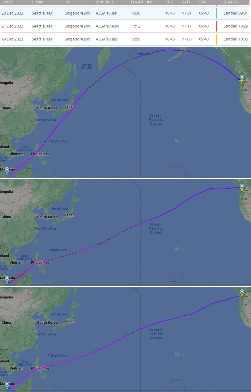
I noticed a couple odd aspects of the flight. First off, our flight path appeared to be quite a bit south of the great circle routing - in fact we passed not far from the Midway Island group. It was also shown quite a bit longer than I get for a great circle routing - over 14,000 km vs. just under 13,000 km that is shown for the great circle route. We arrived nearly on time (slightly delayed landing due to air traffic congestion around Singapore, but for that it would have been within a few minutes of the published schedule), so I have to assume this wasn't an unanticipated re-routing. Could the route have been due to the wind patterns (I never saw more than 100 km/hr. headwind, which is somewhat better than I'm used to seeing heading westbound from the US to Asia)? Or is there a reason I'm not seeing for normally routing us that much further south than the great circle?
Second, I though cruise altitude assignments were always at even 1,000 ft. increments - but I saw the cruise altitude gradually increase - from 38,000 ft to 38,500 to 39,000 to 39,500 to 40,000 ft. I've never seen that before. I remember from my college days that the most fuel efficient cruise was a "climbing cruise" (basically hold constant power and allow the aircraft to climb as it burned off fuel) - is this an attempt to get some of that efficiency gain?
Not really important, but it peaked my engineering curiosity...
TIA

Just imagining your route in my head, haven't plotted it on a globe, but: deliberately not overflying Russia perhaps ? (or even China, maybe).
I don't know about the altitudes, but have sadly not flown for several years. As you say, might be a trial of continuously variable cruise altitude over a relatively quiet route ?
Happy Christmas ! - I am just off to ring the local Cathedral bells.
I don't know about the altitudes, but have sadly not flown for several years. As you say, might be a trial of continuously variable cruise altitude over a relatively quiet route ?
Happy Christmas ! - I am just off to ring the local Cathedral bells.

A couple of days ago, I flew Seattle to Singapore on Singapore (A350 non-stop). During the flight, I periodically would check the flight path with the onboard flight in-flight entertainment system.
I noticed a couple odd aspects of the flight. First off, our flight path appeared to be quite a bit south of the great circle routing - in fact we passed not far from the Midway Island group. It was also shown quite a bit longer than I get for a great circle routing - over 14,000 km vs. just under 13,000 km that is shown for the great circle route. We arrived nearly on time (slightly delayed landing due to air traffic congestion around Singapore, but for that it would have been within a few minutes of the published schedule), so I have to assume this wasn't an unanticipated re-routing. Could the route have been due to the wind patterns (I never saw more than 100 km/hr. headwind, which is somewhat better than I'm used to seeing heading westbound from the US to Asia)? Or is there a reason I'm not seeing for normally routing us that much further south than the great circle?
Second, I though cruise altitude assignments were always at even 1,000 ft. increments - but I saw the cruise altitude gradually increase - from 38,000 ft to 38,500 to 39,000 to 39,500 to 40,000 ft. I've never seen that before. I remember from my college days that the most fuel efficient cruise was a "climbing cruise" (basically hold constant power and allow the aircraft to climb as it burned off fuel) - is this an attempt to get some of that efficiency gain?
Not really important, but it peaked my engineering curiosity...
TIA
Your route would have been optimized to avoid headwinds as much as possible and of course to not enter Russian airspace
As for the flight levels you were at, its most likely the crew requested and received permission to fly a �block altitude� for example from FL 390 to FL 430, this would allow them to climb as they burned off fuel and stay as close as possible to Optimum or Recommend altitude
I think this is what we're talking about, flight on the 19th doing the extreme gradual stepclimb to 400. Only on the 21st, 430 was final level.
Within a few days, route wise both great circle and 'alternative' routing was flown. So not sure ETOPS came into play, wind optimization more plausible.
Over to the more qualified
Within a few days, route wise both great circle and 'alternative' routing was flown. So not sure ETOPS came into play, wind optimization more plausible.
Over to the more qualified
My best guess is to avoid areas of moderate or even severe turbulence over the Pacific related to bends in the Jetstream.
https://www.netweather.tv/charts-and-data/global-jetstream#2023/12/25/0600Z/jetstream/surface/level/overlay=jetstream/orthographic=-178.19,48.59,724
https://www.netweather.tv/charts-and-data/global-jetstream#2023/12/25/0600Z/jetstream/surface/level/overlay=jetstream/orthographic=-178.19,48.59,724
Thread Starter
I think DIBO is on the right track - my flight was on the 19th, and the route I observed was consistent with what's shown on the bottom map. I doubt ETOPS played a factor - A350 has at least 180 minutes and besides going further south would make most potential alternates more distant, not less.
I just expected to see a route similar to the top map in DIBO's post, not the bottom that we apparently actually flew.
I was a little disappointed that we didn't fly closer to Alaska - some of the most spectacular stuff I've ever seen on a commercial flight was flying over southern Alaska on a beautiful clear day with all the snow covered mountains and ice flow spotted ocean. Then again it was pretty overcast so I wouldn't have been able to see much regardless.
Having flown LAX to SIN many times the southern route is by far the most economical because you will invariably experience tailwinds for the vast majority of the time. Usually headwinds only kick in around the Philippines. I seem to remember that when Singapore Airlines first flew this route they followed the great circle route until a captain crunched the figures and proved the south was much better. I believe he was awarded about SGD10,000 for his idea.
