


What exactly is an altitude restriction (Jepp)?

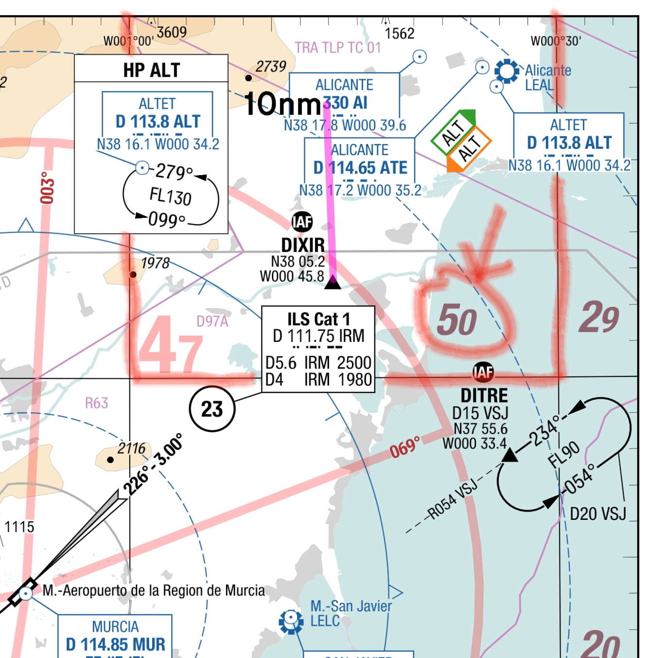
Assuming you overflew DITRE at the start of the arc, then because that is the (an!) IAF and you have an approach clearance, you are cleared to continue descent via the procedure - not below 090 until crossing the MUR 051 bearing (open triangle on the Jepp), then not below 075 until crossing DIXIR. But in the initial question, they were cleared DCT DIXIR, so there is no arc involved.

Originally Posted by CW247
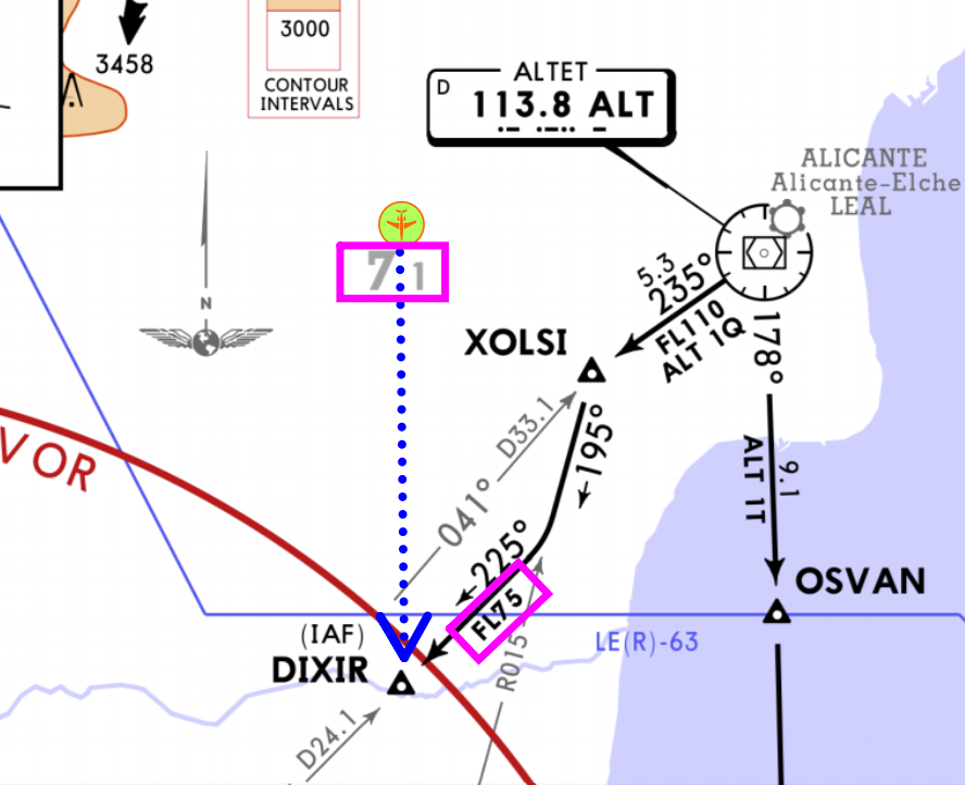
I could be having a brain fart but according to what logic is FL75 an altitude restriction at DIXIR?
Originally Posted by Parishilton
then not below 075 until crossing DIXIR
Join Date: Apr 2011
Location: Doha
Age: 13
Posts: 461
Likes: 0
Received 0 Likes
on
0 Posts
then not below 075 until crossing DIXIR

Ignoring the STAR plate 30-2, If coming from a different direction direct to DITRE then the arc, where are you getting this 075 figure from ? Where on the 31-1 ILS Rwy 23 plate does it mention 075 ? How do you know after radial 051 what you can do. Where is any of this written on plate 31-1
What you descend to prior to DIXIR on a direct routing from a random position is another thing entirely. As the Transition Level is very close to or below the MSA in places, Flight Levels are not a good thing to base terrain clearance on, so I presume at least some of the restrictions are due to the proximity of Alicante’s approach and departure lanes, and that was the concern of the controller, not an imminent CFIT?
Originally Posted by Fullwings
so I presume at least some of the restrictions are due to the proximity of Alicante’s approach and departure lanes, and that was the concern of the controller, not an imminent CFIT?
Ignoring the STAR plate 30-2, If coming from a different direction direct to DITRE then the arc, where are you getting this 075 figure from ? Where on the 31-1 ILS Rwy 23 plate does it mention 075 ? How do you know after radial 051 what you can do. Where is any of this written on plate 31-1
assuming no ATC surveillance
Join Date: Mar 2006
Location: USA
Posts: 2,527
Likes: 0
Received 0 Likes
on
0 Posts
I don't see FL75 as an altitude restriction being cleared direct to. FL75 is a minimum for a procedural transition. If non-radar I would expect off route descent clearances based on distance from the fix/beacon. Even the Italians used to ask for distance before issuing descent clearances, felt reassuring.
Join Date: Jun 2007
Location: Wanderlust
Posts: 3,407
Likes: 0
Received 0 Likes
on
0 Posts
The chart shows safety altitude north of DIXIR as 7100. The clearance given descent according to procedure. No matter from where you come to DIXIR procedure doesn't permit descent below 7500 before DIXIR. The ATC waived of lateral procedure asked to maintain the vertical. I don't see any problem. If in doubt ATC should have been asked about descent below 75 before DIXIR.
https://www.google.com/url?sa=t&sour...dnWxTl57JT2idb
https://www.google.com/url?sa=t&sour...dnWxTl57JT2idb
Vilas, that FAA doc is irrelevant. It's about missing stepdown fixes on the ILS when it's hot. Nothing to do with dodgy "do this but comply with that" type-instructions these guys got. What does "comply with the procedure" mean? The ILS, The STAR? The controller shouldn't have used those terms, the ILS AIP chart should have 7500 at DIXIR and Jeppesen, well, they can try to keep up please.
"Surveillance" or lack-thereof, doesn't have anything to do with it, IMO. ATC cannot clear you to an altitude that does not provide the legal terrain clearance unless their clearance is qualified in some way. It doesn't matter if ATC can "see you" or not. They are still obligated to provide you with terrain clearance.
Last edited by parishiltons; 15th Oct 2022 at 08:08.
Originally Posted by Paris
These are two different things.
Join Date: Jan 2006
Location: Between a rock and a hard place
Posts: 1,267
Likes: 0
Received 0 Likes
on
0 Posts
The chart shows safety altitude north of DIXIR as 7100. The clearance given descent according to procedure. No matter from where you come to DIXIR procedure doesn't permit descent below 7500 before DIXIR
Having FL restrictions rather than altitudes implies, at least to me, that this got to do with airspace and not terrain, even though terrain is quite high to the north. I am sure even southern Spain experiences significact low pressure areas over the course of a year.
There is no way the given charts and ATC clearance (as given) can be used to obtain a universal understanding among pilots. Crap charts and crap ATC instruction.
What would I do if I was placed in the same position as the OPs PF, 10nm north of DIXIR, flying direct and cleared for the ILS but for the purposes of the discussion still in IMC? OK, we’re outside the 4,700' 25nm MSA so can’t use that. What’s the MGA between our position and DIXIR? 5,000’ on my chart. Is there a restriction at DIXIR? Yes, 4,100’ on the approach plate (we are not flying a STAR). Right: set 5,000’ initially, then 4,100’ crossing DIXIR. Capture the LOC then the GS, carry on as normal. Depending on whether I was in the mood for a CDFA or not and our energy state, we would cross DIXIR somewhere between 5,000’ and 8,000’.
If ATC wanted us to stop descent at some level/altitude they would have instructed us to do so. As they haven’t, it's up to us to remain safe w.r.t. terrain, which the above plan does. We have been cleared for the ILS, so we can take it all the way down to DH and further if we have the required references and landing clearance.
Only half a speed-brake
The OP has been served a leaky ATC clearance. Yet that is exactly when a competent aviator earns his bread.
FullWings The carefulness of the analysis is nice. But moreover, unlike other naratives above, the whole philosophy of your post is (as expected) aboslutely right by looking for a valid descent limit to use and no-one should accept any different. Slightly more up, debate got a bit derailed towards 'prove me I cannot descent this low'. which was most concerning.
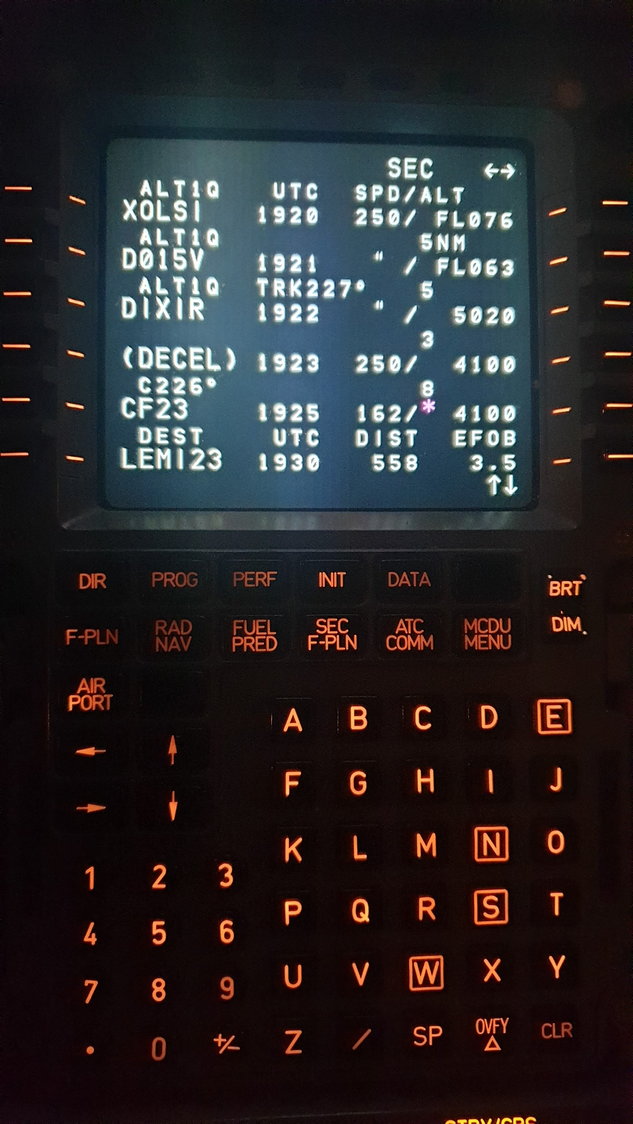
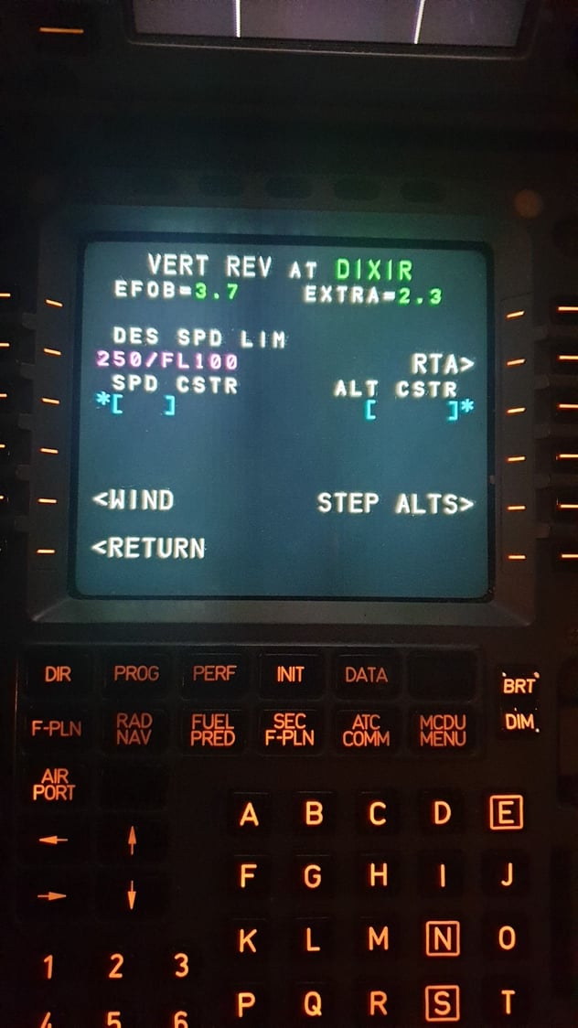
Having said that to ensure you we are both squarely on a same team, my result is still different. Took a liberty to visualize the layout you talked about:
My choice is FL75 and seek clarification. If on the flight-deck in any role I would had to insist to the whole breadth of modern CRM.
To avoid any doubts, even it MORA was 4500 my strong and accordingly worded preference would be FL75 or explicit clearance for any lower.
FullWings The carefulness of the analysis is nice. But moreover, unlike other naratives above, the whole philosophy of your post is (as expected) aboslutely right by looking for a valid descent limit to use and no-one should accept any different. Slightly more up, debate got a bit derailed towards 'prove me I cannot descent this low'. which was most concerning.
Having said that to ensure you we are both squarely on a same team, my result is still different. Took a liberty to visualize the layout you talked about:
My choice is FL75 and seek clarification. If on the flight-deck in any role I would had to insist to the whole breadth of modern CRM.
To avoid any doubts, even it MORA was 4500 my strong and accordingly worded preference would be FL75 or explicit clearance for any lower.
Thanks FD.
It just goes to show that the nav data provider makes quite a difference when you have to practically apply stuff. What is 7100 on your chart is 5000 on mine as the Minimum Grid Altitudes appear to cover smaller sections in this example. Both are safe and in this particular case stopping at 7100 (6500 AAL) until 23+ miles out shouldn�t cause any great problems.
If unsure, ask, as you say, but sometimes clarification will not be available and you need a plan that doesn�t rely on an external agency.
Thread Starter
Join Date: Apr 2013
Location: Neither here or there
Posts: 317
Likes: 0
Received 0 Likes
on
0 Posts
Join Date: Dec 2021
Location: London
Posts: 55
Likes: 0
Received 0 Likes
on
0 Posts
As others has said, why the rush to descend? It showed poor energy management by the crew.
IAW the chart you show, an aircraft flying the 25d arc (which you were not) would maintain FL 090 until established LLZ. Still plenty of distance to descend to the 12.3d/4100’ platform. So no harm at all in sticking to the procedural route level of FL 075 that you had expected? Use the old x3 distance/height checks they aid energy management; it’s a useful tool and costs nothing.
What was the pre-briefed and re-briefed ‘plan’? Following the new clearance you must have had an exchange with your PF as to his plan? All clear was it?
If in doubt, ASK ATC to clarify their instruction. Just because you are not receiving a ‘radar’ service does not mean they are not watching you on radar, nor does it absolve you of responsibility- if anything, you should be even more careful. Apply AIRMANSHIP, or is that a dirty word these days?
And why these restrictions of FL 090 and FL 075? No idea, but perhaps outbound aircraft could be routing below those levels?
It just shows how the modern era of button pressing and the norm of a controlled radar environment fails to equip the inexperienced operator when the non-normal occurs.
Last edited by common toad; 16th Oct 2022 at 08:23.