


Latitude limitations for the use of IRS


Joined: Feb 2000
Posts: 4,704
Likes: 589
From: 500 miles from Chaikhosi, Yogistan
And I believe they can update position referencing known underwater topography.
Which is probably one of the many reasons why why the Chinese were doing this. https://www.abc.net.au/news/2019-04-...r-png/11028192
Which is probably one of the many reasons why why the Chinese were doing this. https://www.abc.net.au/news/2019-04-...r-png/11028192
Joined: Feb 2019
Posts: 431
Likes: 0
From: shiny side up
Submarine navigation uses/used Very Low Frequency radio waves which can penetrate under water.
When GPS was initiated 2 years later, the Omega Towers and system were abandoned.
radio waves nor GPS penetrate water. The systems use sound navigation (SONAR) for navigation. Certain systems place pingers, which provide location underwater, but this is very, very new.
Its all up to the inertial system..

Joined: Jul 2010
Aviation Qualifications: ATPL
Posts: 1,775
Likes: 277
From: Asia
https://fas.org/nuke/guide/usa/c3i/vlf.htm
VLF can penetrate seawater to around 20m, getting close to the surface and raising an antenna improves things considerably. Inertial navigation drifts over time and needs periodic updates to maintain accuracy.
VLF can penetrate seawater to around 20m, getting close to the surface and raising an antenna improves things considerably. Inertial navigation drifts over time and needs periodic updates to maintain accuracy.
Joined: Feb 2019
Posts: 431
Likes: 0
From: shiny side up
But look at when the Omega system went live, 1971....but did not have worldwide coverage. (Woodside in AUS was not opened until 1982.)
It took a long time to get a position from the Omega system and 20m depth is basically on the surface for a sub.
Yes, there are hyper accurate maps that are used in navigation, it just requires the sub to ping with SONAR, giving away its position. There are pingers set up that broadcast all the time, and those are effective (unless the sub shadows a ping and gives itself away!)
On a side note, we were using the Woodside Omega tower for a project, before the idiot killed himself jumping off of it, and it was demolished...too bad.
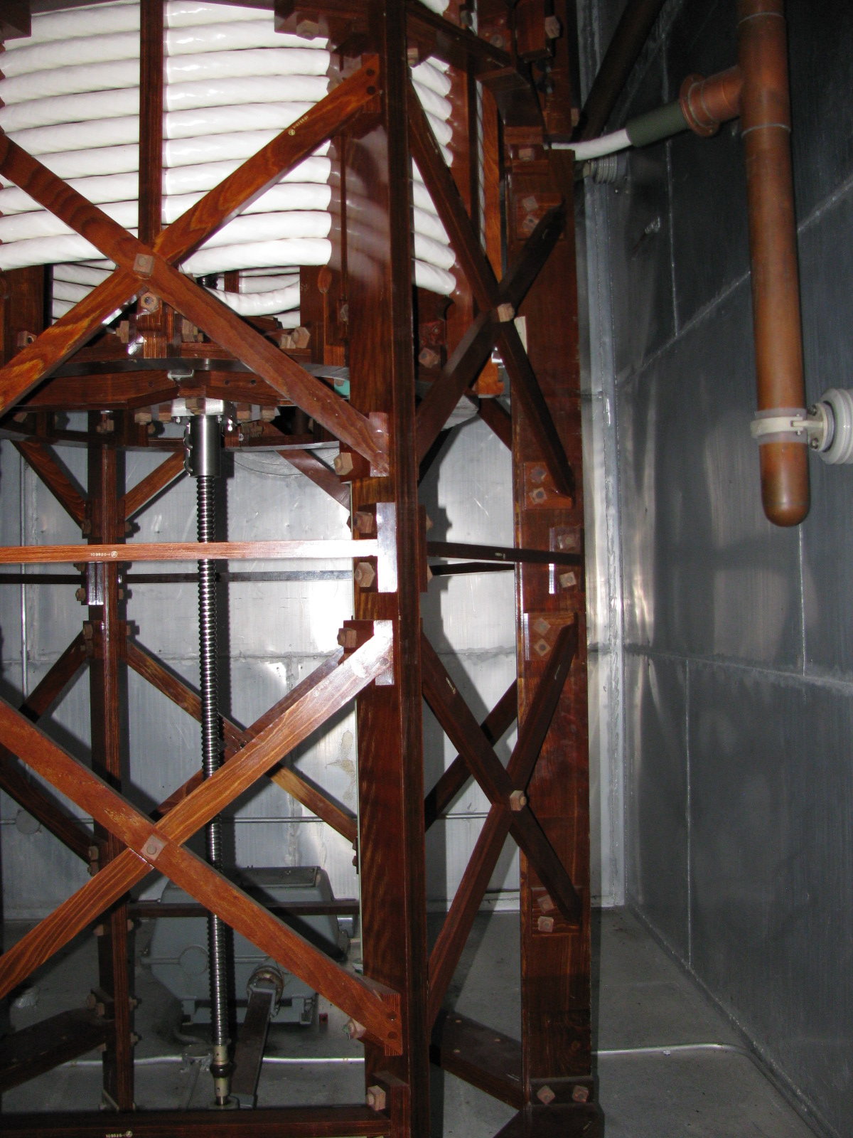
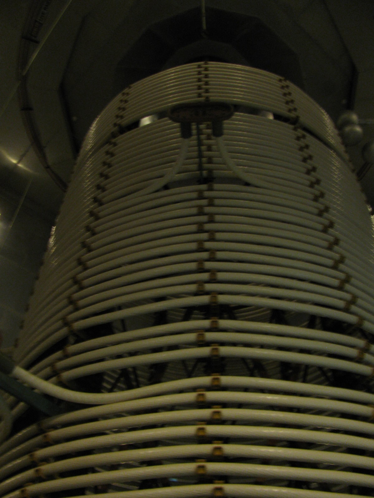
For a bit of history, inside an Omega bunker:
Signal generator 100mm copper coils, all wood frames and bolts were MSR plywood..quite the engineering. (there were 10 of these, 10m tall in the building)

It took a long time to get a position from the Omega system and 20m depth is basically on the surface for a sub.
And I believe they can update position referencing known underwater topography.
On a side note, we were using the Woodside Omega tower for a project, before the idiot killed himself jumping off of it, and it was demolished...too bad.
For a bit of history, inside an Omega bunker:
Signal generator 100mm copper coils, all wood frames and bolts were MSR plywood..quite the engineering. (there were 10 of these, 10m tall in the building)
Last edited by Smythe; 9th May 2019 at 17:20.
Joined: Apr 2008
Posts: 116
Likes: 0
From: back of beyond
Yes, there are hyper accurate maps that are used in navigation, it just requires the sub to ping with SONAR, giving away its position.
The gear required to measure the acceleration due to gravity to a fraction of a percent in a surface vessel subject to wave motion has to be seen to be believed.

Joined: Oct 2017
Posts: 4
Likes: 0
From: UK
Perhaps hoss183 really doesn't understand that the value or Cosine Latitude diminishes towards the true poles.
In fact I don't think he understands as much as he would like us to think.
Our inertial platform would work at the poles, but alignment north of about 78-80N took eons.
In fact I don't think he understands as much as he would like us to think.
Our inertial platform would work at the poles, but alignment north of about 78-80N took eons.
Joined: Mar 2014
Posts: 67
Likes: 0
From: SW USA
A few more tidbits on the submarine voyages --
A 4 page article in Popular Science in 1959, "How the Nautilus Hit the Bull's-Eye at the Pole":
North American Aviation retirees' newsletter (9 MB file). Article starting on pg. 4 with a technician's log of his trip under the pole aboard the USS Skate, taking place at the same time as the Nautilus voyage.
AIAA paper on N6A, free page 1, all others pay cash:
Joined: Sep 2010
Aviation Qualifications: ATPL
Posts: 884
Likes: 233
From: by the seaside
DC10 polar flights 1980s
I had the "honour" of doing our first flight over the pole.
it would have been in the extended range version as fuel was tight and we often planned Fairbanks with technical onroute diversion to our destination of Anchorage.
Dispatch was excited and the over the top route was only a couple of minutes longer than minimum time.
The INS took 12 minutes to initialize including loading the route from a betamax size cassette.
I do not remember any lattitude restriction wrt initialization.
Above 65? we had to go to polar navigation which split the two fms displays, the computers worked on individually calculated position rather than median and we were not allowed to take out the nav mode on the autopilot.
All went well until we crossed the pole with my display showing a normal indication to the next waypoint (328?nm) whilst the captains showed a track which deviated approximately 30 degrees.
I tried "direct to" on both key pads but was still left with a large track split. Fortunately we had been watching a large moon in the night sky so we had some sort of heading reference.
I checked the triple lat long displays which all were fairly similar and decided with the skipper and engineers blessing that I would ignore SOP, take out nav and manually intercept the meridian. When we reached the next waypoint everything went back to normal.
I wrote it up very clearly but a month later I got a huge bollxxking for ignoring SOP which would be entered on my file.
This was not entirely unexpected as far to many mangement pilots in all of my three legacy carriers didnt have the where with all of line pilots, the exception being technical and base trainer pilots.
A month later I was rostered to assist on a sim check which was being carried out by the chief technical pilot whom I didnt know but I thought that it was a serious problem that should be properly investigated.
It was and I recieved a note that Douglas had discovered a programming error which had been rectified.
Last edited by blind pew; 10th May 2019 at 08:06.
Joined: Feb 2000
Posts: 4,704
Likes: 589
From: 500 miles from Chaikhosi, Yogistan
Great story BP - thanks for posting.
It reminds me of one from one of my colleagues back in the late 70s or early 80s. He was flying a biz jet to the N Pole with a load of some half a dozen nav engineers and their latest nav equipment in the back to test. Approaching the pole, they were counting the number of (latitude) minutes from 89�N. In rough unison each engineer called out 56, 57, 58, as the latitudes clocked over, then 59 , 00 then 59 again, except one voice that piped up 61...
It reminds me of one from one of my colleagues back in the late 70s or early 80s. He was flying a biz jet to the N Pole with a load of some half a dozen nav engineers and their latest nav equipment in the back to test. Approaching the pole, they were counting the number of (latitude) minutes from 89�N. In rough unison each engineer called out 56, 57, 58, as the latitudes clocked over, then 59 , 00 then 59 again, except one voice that piped up 61...

Joined: May 2000
Posts: 3,203
Likes: 2
From: Seattle
Which Boeing? The 744 FCOM says:
IRS HIGH LATITUDE ALIGNMENT
A high latitude alignment must be accomplished when the latitude of the origin airport is greater than 70�12.0� and less than 78�15.0�.
IRS Mode selectors ............................................................ ...... OFF, then ALIGN
Note: The IRS Mode selectors must remain in ALIGN for a minimum of 17 minutes.
CDU ............................................................ ................................................... Set
Enter present position on SET IRS POSITION line of position initialization page.
IRS mode selectors ............................................................ ...........................NAV
Joined: Jun 2009
Posts: 1,344
Likes: 80
From: Bedford, UK
Well as I understood it an INU in gyrocompass mode is using its rate sensing gyros to detect earth rotation. If the X axis is fore aft, z upwards, then it rotates about the z axis until no earth rate is detected on the y axis, so the earth rotation vector is in the x z plane. At the pole the rotation vector is straight up z no matter how you rotate to swing the X axis around. So the component of the earth rate that matters is in the x y plane. This reduces as cosine latitude.
