


Geopotential or geometric feet?

Thread Starter

Joined: Mar 2016
Posts: 5
Likes: 0
From: @Home
For a project I need to calculate the orthometric altitudes of flying aircraft.
Flight altitudes above the Transition Altitude and Transition Level as reported by ADS-B (in Plane Plotter logs) are barometric altitudes.
But... are these pressure heights expressed in geopotential or geometric feet?
And in what units are they expressed below the Transition Altitude and Transition Level, or are these already reported as orthometric below TA/TRL?
Is there some ICAO or other reference document where this is clearly stated (e.g. it's not in ICAO Doc 7488/3) ?


Joined: Aug 2013
Posts: 30
Likes: 0
From: PA
Depending on the FMS manufacturer, there are several methodologies used. One uses a grid over the WGS84 ellipsoid, with a lookup feature, ie if this is your lat/long, this is the altitude above the ellipsoid. Others actually calculate referencing the ellipsoid.
It does not use geopotential.
It does not use geopotential.

Joined: Aug 2013
Aviation Qualifications: Military (Retired)
Posts: 1,345
Likes: 562
From: Washington.
If the ADS-B is reporting barometric altitudes above the transition level, the altitudes are feet above the 29.92 inches Hg (1013 hP) pressure surface.
Is not a geometric altitude the height above a particular ellipsoid, as in WGS84, which is regardless of pressure.
Is not a geometric altitude the height above a particular ellipsoid, as in WGS84, which is regardless of pressure.
Thread Starter
Joined: Mar 2016
Posts: 5
Likes: 0
From: @Home
Geopotential or geometric feet?
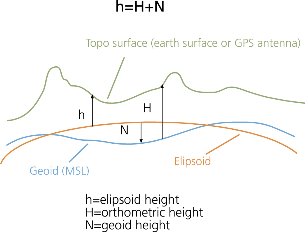
I know what ellipsoidal heights and the geoid mean - that's what is used when calculating the orthometric altitude.
The question remains : what units are barometric altitudes (flight levels) reported in ADS-B logs, geopotential or geometric??
This answer claims it's geopotential :
What is the Difference between geopotential altitude and geometric altitude
What I need is an official reference about this issue to make sure.
Joined: Aug 2013
Posts: 30
Likes: 0
From: PA
2.2 Geometric Altitude
GPS geometric altitude is a measure of the vertical distance between an aircraft and the MSL. This is the height information calculated by the on-board GPS receiver based on a constellation of at least 4 GPS satellites, and is broadcasted to ground stations via ADS-B. However, GPS uses WGS84 ellipsoid as an approximation to the MSL, which could have errors between -100m and 70m with respect to the geoid, depending on location on the globe. The geoid is the best definition of the MSL, which is used as the reference for pressure altitude.
http://www.icao.int/APAC/Meetings/20...20Altitude.pdf
This goes back to my first post, where some ac have a lookup table, and others calc to the geoid, due to the differences in MSL vs Geiod. Some FAA and ICAO equations still use the Earth as a simple fixed diameter!
It is a good question, and there is much confusion, as the standard, and how the ac uses the informastion have been evolving...as has the understanding of the variations in MSL.
Last edited by underfire; 8th March 2016 at 01:06.
Thread Starter
Joined: Mar 2016
Posts: 5
Likes: 0
From: @Home
Thanks for the reference!
It basically confirms what I already knew : ADS-B CAN transmit both barometric and geometric altitude, but only barometric is important (standard) for ATC.
If it is geometric (ellipsoidal NOT orthometric!) altitude that is in the Plane Plotter log - unlikely, but I have to confirm this - then everything is clear to me.
If it is barometric altitude - most likely - then I'm still stuck : barometric altitude can be expressed in geopotential feet AND geometric feet, as indicated in the implemented standard ICAO Doc 7488/3.

Joined: Mar 2008
Posts: 423
Likes: 1
From: Malvern, UK
Well as ADS-B reports barometric altitude then this is based on the Standard Atmosphere. The Standard Atmosphere is defined in geopotential feet. So that is presumably your answer. Though as barometric is intended to give a relative separation between aircraft in what is only ever an approximation to Standard Atmosphere, and which bears little relation to height above the surface I am not sure where this becomes important.
As a matter of interest...
ADS-B can in principle report Barometric or Geometric altitude in the main position report. However barometric is used pretty much universally for obvious operational reasons.
However: When reporting barometric in the position report, suitably equipped aircraft will report "difference from barometric" in the velocity report. This is a 7 bit field plus sign-bit and is limited to 3125 ft difference between barometric and geometric.
So you actually get both for your money.
Why height information in the velocity report? Well there was a bit of space going spare, while the position report is crammed full!
Last edited by Dont Hang Up; 9th March 2016 at 08:41.
Thread Starter
Joined: Mar 2016
Posts: 5
Likes: 0
From: @Home
Barometric geopotential altitudes
To put it all together and conclude from what I've read on forums and found in references:
ADS-B definitely reports barometric altitudes that are most likely expressed in geopotential feet.
To convert these into orthometric:
1) Convert geopotential to geometric for all reported altitudes including the fixed TA and variable TRL.
2) Apply QNH only to altitudes above TA and TRL using the barometric and inverse (hypsometric) equations derived from ICAO Doc 7488/3 expressed in geometric heights.
Joined: Mar 2008
Posts: 423
Likes: 1
From: Malvern, UK
No, the ADS-B barometric is always referenced to 1013mb regardless of height. So you would need to apply QNH for all ADS-B reports.
This is always going to be approximate. Even assuming you have access to all the QNH data it is not super accurate - it may be a worst case period forecast for a region. Then the deviation of the real atmospheric conditions from the Standard Atmosphere will also add error.
Where it is available use "difference from barometric" in the ADS-B velocity reports as this will give you a true measure of GPS geometric height to the best accuracy the aircraft can provide - which again is not super accurate but perhaps better than the multiple approximations that the barometric conversion will give you.
The barometric "foot" is a somewhat flexible animal. It is useful for safe separation because of its universal applicability - and to do that it only needs to work as a relative measurement over quite short distances. It is not great as a surveying tool though.
Thread Starter
Joined: Mar 2016
Posts: 5
Likes: 0
From: @Home
Barometrics
This could explain why sometimes I notice reported altitudes hundreds of feet below ground when the aircraft has not landed yet.
Meaning that I don't have to mess with TA and TRL neither?
Applying QNH to all the reported barometric altitudes would simplify things quite a bit.
This is always going to be approximate. Even assuming you have access to all the QNH data it is not super accurate - it may be a worst case period forecast for a region. Then the deviation of the real atmospheric conditions from the Standard Atmosphere will also add error.
I know it'll be approximate, and I even doubt it will make any difference in what I intend to do - calculate bistatic Doppler signals from flight data and compare them with real signals in radio spectrograms.
Simulations showed that the altitude parameter is by far least affecting the shape of the signals.
Doppler signals of aircraft mess up spectrograms intended for the study and counting of radio meteors.
If I can accurately calculate them using real flight data, I could also erase them.
So far scientists use sophisticated signal processing algorithms that give too many false positives or negatives to be useful, all due to an airspace cluttered with aircraft.
Where it is available use "difference from barometric" in the ADS-B velocity reports as this will give you a true measure of GPS geometric height to the best accuracy the aircraft can provide - which again is not super accurate but perhaps better than the multiple approximations that the barometric conversion will give you.
So, rephrasing the rules I intend to apply:
ADS-B reports barometric altitudes that are expressed in geopotential height.
To convert these into orthometric:
1) Convert geopotential to geometric for all reported altitudes.
2) Apply QNH to all reported altitudes using the barometric and inverse (hypsometric) equations derived from ICAO Doc 7488/3 expressed in geometric (orthometric) heights.
Is this correct?
Joined: Aug 2013
Posts: 30
Likes: 0
From: PA
So you're saying ADS-B sends GPS altitude not barometric altitude. Well I've just learned something.
Barometric altitude is used for air traffic separation and must be corrected for pressure/temperature. Geometric altitude is what the GPS system provides, and is what RNAV avionics use, and many ATM systems that use the broadcasts...

The system on the aircraft has to be able to calc the differences between the ellipsoid, the geoid, and the measurement. This why there are calculations in the fms. The GPS system in the ac references the WGS84 ellipsoid. Procedure designs use this as the basis for the altitudes for the coded procedures.
Note Australia has a very unusual geoid-ellipsoid seperation, so this must be taken into account in the designs that rely on GPS navigation (like WAAS/GBAS)
-35m to +75m correction...

As shown on this representation, a GPS that uses an approx value for lat/long, depending on the internal grid size, could be off quite a bit...
then there are the studies...
Findings showed obvious variation between the altitudes during different phases of flight. The barometric altitude displayed higher readings than geometric height while the aircraft is cruising. The discrepancies between the two altitudes were bigger during the climbing phase. It is also found that the absolute difference between geometric height and barometric altitude ranges from 25 feet – 1325 feet with an average of 569 feet.
Just to note, GLONASS, of course, uses a different ellipsoid....
Joined: Mar 2008
Posts: 423
Likes: 1
From: Malvern, UK
I know it'll be approximate, and I even doubt it will make any difference in what I intend to do - calculate bistatic Doppler signals from flight data and compare them with real signals in radio spectrograms.
At very low and very high elevation angles between ground sensor and target the effect of height errors becomes negligible. The worst sensitivity to height errors will be for an elevation angle of around 35 degrees.
However the actual error will depend upon the distances involved. Clearly a 1000ft height error on a target at FL300 will have far less effect than a 1000ft height error on a target at 3000ft.
Joined: Jun 2006
Posts: 265
Likes: 0
From: Brisbane
I'm no expert in this area, but I take it you trying to ascertain the geometric height of an aircraft with the information available (which unfortunately does not include GPS altitude).
So you are starting with a barometric ADS-B readout, and applying local QNH to give a geopotential height (ignoring transition level, as you have stated - it's irrelevant), which you then convert to geometric.
That sounds fine, but you could probably get more accurate than this.
Firstly, QNH will be accurate when an aircraft is near the ground, but sea-level pressure variations may be of little use for an aircraft at a higher level. You may be better off looking for upper air charts. High level highs and lows do not necessarily correspond to low level highs and lows.
The next step then needs to be temperature correction. In cold weather the aircraft will be lower than it is broadcasting, and vice versa. Once again, sea level temperatures will be of no use (it may be ISA+20 on the ground but ISA-10 at high level), and in fact the QNH includes a temperature correction for ambient, but only valid for the height of the source of the QNH. This page may help. Again, air charts are available for temperature. At heights above 36000 feet, ISA assumes a zero temperature lapse rate (stratosphere). I actually don't know if aircraft altimeters are calibrated to correct for this, but I doubt it. Assuming that they don't, aircraft above 36000 feet is ISA conditions (-57C) are probably slightly higher than they think they are, so your temperature corrections probably need to disregard the tropopause also. Perhaps someone can help with this.
Anyway, the point is that actual temp/pressure corrections for the altitude of the aircraft will give you the most accurate geopotential height that I can think of.
