


MAPt/DA - LOWG

Thread Starter
Joined: Apr 2010
Posts: 1,319
Likes: 100
From: IRS NAV ONLY
MAPt/DA - LOWG
Hi!
I seem to have a bit of a problem with understanding where must the missed approach be initiated in the following example.
The VOR/DME approach for runway 35C in Graz (LOWG) requires you (on Jeppesen chart 13-2, conforming to EU OPS reuqirement to fly the non-precision approaches as CDFA) to fly level to GRZ NDB at 2300' and then descend via the 3.15� path towards the runway. Missed approach point is GRZ VOR and the decision altitude is 1500'. The problem is, table provided by the Jeppesen states that at 0 DME (effectively over the VOR and at MAPt) aircraft's altitude should be 1600', which is 100ft above the DA.
From ICAO Doc 8168:
So basically, as it seems, you are required to initiate the missed approach overhead the VOR at 1600ft, when you are still 100ft above DA. Seems pointless to me that DA is then published at 1500ft, when there is no way to actually reach it, unless you descend below the CDFA profile. The situation becomes even more strange, when you check the chart in the Austrian AIP, which shows that you should be at 1500ft over the VOR (MAPt).
Any clarification on this subject would be highly appreciated.
I seem to have a bit of a problem with understanding where must the missed approach be initiated in the following example.
The VOR/DME approach for runway 35C in Graz (LOWG) requires you (on Jeppesen chart 13-2, conforming to EU OPS reuqirement to fly the non-precision approaches as CDFA) to fly level to GRZ NDB at 2300' and then descend via the 3.15� path towards the runway. Missed approach point is GRZ VOR and the decision altitude is 1500'. The problem is, table provided by the Jeppesen states that at 0 DME (effectively over the VOR and at MAPt) aircraft's altitude should be 1600', which is 100ft above the DA.
From ICAO Doc 8168:
6.1.6 If upon reaching the MAPt the required visual reference is not established, the procedure requires that a
missed approach be initiated at once in order to maintain protection from obstacles.
missed approach be initiated at once in order to maintain protection from obstacles.
Any clarification on this subject would be highly appreciated.

Per Ardua ad Astraeus
Joined: Mar 2000
Posts: 18,575
Likes: 4
From: UK
"unless you descend below the CDFA profile." My preferred explanation,
however
" The situation becomes even more strange, when you check the chart in the Austrian AIP, which shows that you should be at 1500ft over the VOR (MAPt)." Is the Austrian AIP based on CFDA or 'dive and drive'?
Aterpster/OBN?
however
" The situation becomes even more strange, when you check the chart in the Austrian AIP, which shows that you should be at 1500ft over the VOR (MAPt)." Is the Austrian AIP based on CFDA or 'dive and drive'?
Aterpster/OBN?


Joined: Mar 2005
Posts: 1,338
Likes: 1
From: Uh... Where was I?
Interesting
It is either a typo or maybe the 3.15� is laid from the LOM at 2300 to the threshold plus 50 ft, so that overhead the VOR the altitude should be 1600, which is 100 ft higher than MDA.
This would mean that in marginal weather it would "pay" to fly this approach dive and drive, as this would enhance the chances of becoming visual in 100 ft (600 m less of visibility that you need).
I think it is a typo
Joined: Mar 2001
Posts: 4,562
Likes: 33
From: I wouldn't know.
It doesn't chart the slope out of 2300ft at the NDB, just a hard minimum altitude limit of 2300ft at the NDB, it starts the approach out of 4000ft in the racetrack or baseturn with the turn at 3300ft and a continous descent out of 3300ft.
Guest
Joined: Apr 2009
Posts: 3,336
Likes: 0
From: On the Beach
5420N:
The descent angle is computed to the runway threshold at a TCH of 53 feet.
Having said that, I don't understand this European system at all, especially where the missed approach point is prior to, and above, the pseudo DA point. The missed approach climbing assumptions in criteria presume a climb at not less than 1,500 and not later than the VOR.
For reference, here is the current Jepp chart. I imagine it is the same as the LIDO chart:
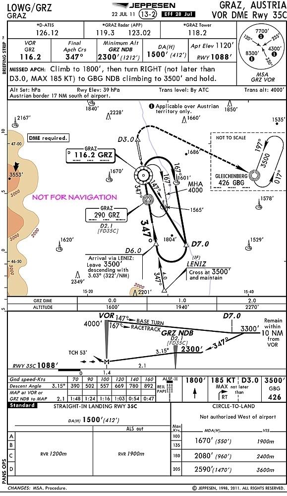
Passing the NDB (LOM) is says 2300. Mapt is 2.1nm further. That is nearly 400ft/nm to achieve 1500ft. That's more than a 3.15 degree slope isn't it?
Having said that, I don't understand this European system at all, especially where the missed approach point is prior to, and above, the pseudo DA point. The missed approach climbing assumptions in criteria presume a climb at not less than 1,500 and not later than the VOR.
For reference, here is the current Jepp chart. I imagine it is the same as the LIDO chart:

Joined: Mar 2007
Posts: 12
Likes: 0
From: Close
The descent angle is computed to the runway threshold at a TCH of 53 feet.
What I'm saying is that the procedure CDFA is 3.6 degrees as per NAVTECH and will get you to 1500 feet over the VOR (MAPt).
It doesn't chart the slope out of 2300ft at the NDB, just a hard minimum altitude limit of 2300ft at the NDB

Joined: Mar 2002
Aviation Qualifications: ATPL
Posts: 9,192
Likes: 961
From: Seat 1A
It looks to me like the designers have decided that 3.15� is the steepest angle/profile they are willing to publish. This will only get the aircraft to 1600ft by the MAPt. The angle required to get to 1500ft by the MAPt is 3.58�, or 380ft/nm, as mentioned. As JAR has pointed out, the profile table is only a recommendation.
This is quite tricky because, the distance between the LOM and the VOR is so short: if you were level at LOM at 2300ft, you'd never comfortably get to 1500ft by the VOR. We have to be "descending passing" LOM at 2300ft on the way down.
To get the advantage of the extra 100ft, the solutions, as I see it, are:
- When passing the LOM (assuming you are already established in, or your FMS database provides, a 3�-ish profile prior to LOM), set VS 1000ft/min. This will get you pretty close to the MDA by the VOR (in effect, a dive with no drive);
- Determine and then fly a constant 3.6� approach from say 3000ft, to achieve 1500ft at the VOR, ie DMEx380ft/nm + 1500ft.
I don't understand that. One can't fly a CDA at 3.15� from LOM and achieve 1500ft at the VOR. The slope required from LOM is 3.58�. If one flew 3.03� from LENIZ, you'd go under 2300ft passing the LOM.
This is quite tricky because, the distance between the LOM and the VOR is so short: if you were level at LOM at 2300ft, you'd never comfortably get to 1500ft by the VOR. We have to be "descending passing" LOM at 2300ft on the way down.
To get the advantage of the extra 100ft, the solutions, as I see it, are:
- When passing the LOM (assuming you are already established in, or your FMS database provides, a 3�-ish profile prior to LOM), set VS 1000ft/min. This will get you pretty close to the MDA by the VOR (in effect, a dive with no drive);
- Determine and then fly a constant 3.6� approach from say 3000ft, to achieve 1500ft at the VOR, ie DMEx380ft/nm + 1500ft.
Originally Posted by Denti
my LIDO chart shows a CDFA approach out of 3300 (3500 if starting the approach out of LENIZ) with 3.15� passing the MAPt at 1500.
Last edited by Capn Bloggs; 31st July 2011 at 15:08. Reason: amended slope angle from LENIZ
Guest
Joined: Apr 2009
Posts: 3,336
Likes: 0
From: On the Beach
Capn Bloggs,
The Jepp charts say 3.03 degrees from LENIZ.
It's an NPA that has been attempted to be converted into a silk purse, so to speak.
I don't understand that. One can't fly a CDA at 3.15� from LOM and achieve 1500ft at the VOR. The slope required from LOM is 3.58�. If one flew 3.15� from LENIZ, you'd go under 2300ft passing the LOM.
It's an NPA that has been attempted to be converted into a silk purse, so to speak.
Joined: Mar 2001
Posts: 4,562
Likes: 33
From: I wouldn't know.
On the LIDO it does not start with a level segment in 2300, it starts with a descend out of 3300ft at 5.1 DME for the racetrack or base turn procedure and out of 5.7 DME at 3500ft for a straight in approach out of LENIZ.
Guest
Joined: Apr 2009
Posts: 3,336
Likes: 0
From: On the Beach
Denti,
Can you/would you post the LIDO chart?
On the LIDO it does not start with a level segment in 2300, it starts with a descend out of 3300ft at 5.1 DME for the racetrack or base turn procedure and out of 5.7 DME at 3500ft for a straight in approach out of LENIZ.
Joined: Mar 2002
Aviation Qualifications: ATPL
Posts: 9,192
Likes: 961
From: Seat 1A
I stand minorly corrected. Crunching the numbers, 3.03� from LENIZ to 53ft over the threshold takes you past GRZ NDB at 2267ft and GRZ VOR at 1592ft.
So the designers seem to have forsaken a steeper angle to achieve the MDA by the MAPt. Perhaps it is because, while you were at the MDA at the MAPt, you'd actually be 92ft low on the 3� slope, at only 412ft AAL. That would probably put you too high to be stable.
If confronted with low cloud and good vis underneath, I'd be VSing it down when past GRZ NDB in the hope of breaking visual at the MDA before the MAPt, just below the charted slope.
If low vis is the issue, I'd just run down the 3.03� and accept that I was never going to get to the MDA by the MAPt.
Fixed. 
So the designers seem to have forsaken a steeper angle to achieve the MDA by the MAPt. Perhaps it is because, while you were at the MDA at the MAPt, you'd actually be 92ft low on the 3� slope, at only 412ft AAL. That would probably put you too high to be stable.
If confronted with low cloud and good vis underneath, I'd be VSing it down when past GRZ NDB in the hope of breaking visual at the MDA before the MAPt, just below the charted slope.
If low vis is the issue, I'd just run down the 3.03� and accept that I was never going to get to the MDA by the MAPt.
Originally Posted by Terps
The Jepp charts say 3.03 degrees from LENIZ.
Joined: Mar 2011
Posts: 1,407
Likes: 0
From: engineer at large
With regards to the Jepp chart that terpster provided....
Notice that the MAP is a variable according to your CAT. (MAP at VOR OR...) as an example the CAT C 140kts MAP is 0.54nm from the NDB
the straight in has one cross and maintain 3500 from LENIZ, then somehow dive in at 3.03� from DME6...
I note at the bottom of the chart that recent changes have been made to the procedure. From what I can tell, the chart is not correct as virtually none of these numbers add up.... a quick look at the obstacles charted shows you CANNOT safely use this GPA (looks like a very bad chart! )
)
this is an older chart which appears to correctly show the 5.3% GPA that we all calc'd out..

Mapt is 2.1nm further.
Crunching the numbers, 3.03� from LENIZ to 53ft over the threshold takes you past GRZ NDB at 2267ft and GRZ VOR at 1592ft.
I note at the bottom of the chart that recent changes have been made to the procedure. From what I can tell, the chart is not correct as virtually none of these numbers add up.... a quick look at the obstacles charted shows you CANNOT safely use this GPA (looks like a very bad chart!
)this is an older chart which appears to correctly show the 5.3% GPA that we all calc'd out..
Last edited by FlightPathOBN; 1st August 2011 at 21:25.
Joined: Dec 2006
Aviation Qualifications: CPL
Posts: 433
Likes: 0
From: Hamburg
Notice that the MAP is a variable according to your CAT. (MAP at VOR OR...) as an example the CAT C 140kts MAP is 0.54nm from the NDB
Joined: Mar 2011
Posts: 1,407
Likes: 0
From: engineer at large
No, the MAP is not 0.54 NM from the NDB
thanks!
anyone going to ask Jepp how 322'/nm is 3.03� ?
Did anyone notice if the ILS chart changed as well?
Last edited by FlightPathOBN; 1st August 2011 at 18:35.