


length of the nautical nile

Thread Starter
Joined: Jul 2008
Posts: 43
Likes: 0
From: New Delhi
length of the polar nautical mile
Sorry to sound like a noob but i have a little predicament about the length of the nautical mile. Every place i read it says the length of the is more at the poles ...why?
Everyone knows that radius of earth is less at poles so the pole is closer to the center of the earth ....now my argument is that i take a torch and i switch it on at 1 m away it will have a smaller circumference of light then at 3 meters away... the angle(beam width,if u may) this light subtends remains the same at both places but closer distance is less and far away distance is more...so why is the length of the nautical mile more at poles..
i am assuming this has something to do with geocentric and geodetic latitude but cant figure it out any help highly appreciated...
Last edited by Shabez; 25th March 2011 at 01:27.

Joined: Aug 2003
Posts: 3,833
Likes: 2
From: Sale, Australia
No such thing as a nooby question Shabez.
The nautical mile was historically defined as a minute of arc along a meridian of the Earth, making a meridian exactly 180�60 = 10,800 historical nautical miles. It can therefore be used for approximate measures on a meridian as change of latitude on a nautical chart. The originally intended definition of the metre as 10−7 of a half-meridian arc makes the mean historical nautical mile exactly (2�107)/10,800 = 1,851.851851� historical metres. Based on the current IUGG meridian of 20,003,931.4585 (standard) metres the mean historical nautical mile is 1,852.216 m.
The historical definition differs from the length-based standard in that a minute of arc, and hence a nautical mile, is not a constant length at the surface of the Earth but gradually lengthens with increasing distance from the equator, as a corollary of the Earth's oblateness, hence the need for "mean" in the last sentence of the previous paragraph. This length equals about 1,861 metres at the poles and 1,843 metres at the Equator.
Other nations had different definitions of the nautical mile. This variety in combination with the complexity of angular measure described above along with the intrinsic uncertainty of geodetically derived units mitigated against the extant definitions in favor of a simple unit of pure length. International agreement was achieved in 1929 when the International Extraordinary Hydrographic Conference held in Monaco adopted a definition of one international nautical mile as being equal to 1,852 metres exactly, in excellent agreement (for an integer) with both the above-mentioned values of 1,851.851 historical metres and 1,852.216 standard metres.
Use of angle-based length was first suggested by E. Gunter (of Gunter's chain fame), reference: W. Waters, The Art of Navigation in England in Elizabethan and Stuart Times, ( London, 1958). During the 18th century, the relation of a mile of 6000 (geometric) feet, or a minute of arc on the earth surface had been advanced as a universal measure for land and sea. The metric Kilometre was selected to represent a centisimal minute of arc, on the same basis, with the circle divided into 400 degrees of 100 minutes.
The international nautical mile was defined by the First International Extraordinary Hydrographic Conference, Monaco (1929) as exactly 1852 metres. This is the only definition in widespread current use, and is the one accepted by the International Hydrographic Organization and by the International Bureau of Weights and Measures (BIPM). Before 1929, different countries had different definitions, and the Soviet Union, the United Kingdom and the United States did not immediately accept the international value.
Both the Imperial and U.S. definitions of the nautical mile were based on the Clarke (1866) Spheroid: specifically, they were different approximations to the length of one minute of arc along a great circle of a hypothetical sphere having the same surface area as the Clarke Spheroid. The United States nautical mile was defined as 1853.248 metres (6080.20 U.S. feet, based on the definition of the foot in the Mendenhall Order of 1893): it was abandoned in favour of the international nautical mile in 1954. The Imperial (UK) nautical mile, also known as the Admiralty mile, was defined in terms of the knot such that one nautical mile was exactly 6080 feet (1853.184 m): it was abandoned in 1970 and, for legal purposes, old references to the obsolete unit are now converted to 1853 metres exactly.
Courtesy of Wiki.
Joined: Jan 2011
Posts: 217
Likes: 0
From: on the cusp
Radius vs radius of curvature
I think the problem is in using the term radius.
I'll try to do this verbally rather than mathematically, so please excuse any clumsy use of words.
The term radius of the earth is used to refer to the distance to the centre (or more correctly the focus) of the ellipse.
In order to carry out the calculation of the length or arc, you need to know the radius of curvature. This is the radius of an equivalent circle that would give the same curvature at that point. As the earth is flatter at the poles, so the radius of curvature is greater and therefore the length of arc required to subtend a given angle.
To try and visualise this imagine squashing a ball. Underneath your hand the surface is nearly flat, which implies a large radius of curvature (a flat plate having an infinite radius of curvature). At the edges the curvature is greatest, giving a small radius of curvature. Push enough and the shape almost becomes a running track with a tight circle at either end and a flat upper and lower surface.
Imagine looking at a cross section through a line of longitude and trying to draw a circle that touches the earth at the poles, this would have to be larger than the earth as the earth would start to curve away more towards the equator. Similarly any circle that touches the equator, would be smaller than the earth as it would curve faster inside the earth as the earth started to flatten. This leads to the effect you have quoted.
In reality it is not that simple, as the Earth is not simply a squashed sphere, but I hope that helps you visualise the answer to your question.
Edit: Just to be clear the international nautical mile is defined as exactly 1,852m. What I think is under discussion is now called a sea-mile, which varies with latitude. The value 1,852m is the closest integer to the mean value of a sea-mile.
Last edited by dClbydalpha; 25th March 2011 at 09:33. Reason: Clarification
Guest
Joined: Apr 2009
Posts: 3,336
Likes: 0
From: On the Beach
This is what is used in TERPS. I presume PANS-OPS is the same:
Distances. Develop all distances in nautical miles (NM) (6076.11548 feet or 1852 meters per NM) and hundredths thereof, except where feet are required. Use the following formulas for feet and meter conversions:
feet = meters/0.3048 meters = feet x 0.3048
Distances. Develop all distances in nautical miles (NM) (6076.11548 feet or 1852 meters per NM) and hundredths thereof, except where feet are required. Use the following formulas for feet and meter conversions:
feet = meters/0.3048 meters = feet x 0.3048

Joined: Jul 1999
Posts: 3,040
Likes: 0
From: 58-33N. 00-18W. Peterborough UK
We should have stuck with Cubits. Much more sensible.
'The book told me that the Cubit was once a specific linear measure of 18.24 inches, not the average length of an Egyptian forearm as we are taught. From where had she got this two decimal point information? Was there anything particularly significant about 18.24? A pocket calculator soon told me. One Radian, 57.3 degrees divided by one Cubit = 3.141, Pi. Now that is very significant; a connection between an ancient measure and geometrical reality. Remember that Pi is supposed to have been 'discovered' by the Greeks, after hundreds of years of research.
But how far did this connection go? One relationship clearly existed but was there any other connection, such as linear measures.
For navigational purposes the Earth is divided into 360 degrees with each degree divided into 60 minutes, and each minute divided into sixty seconds.
One minute of arc, from the centre of the earth, is 6,080 of today's feet, or 72,960 inches. 72,960 divided by 18.24 = 4,000. So a minute of arc is the clumsy number of 6,080 feet, or exactly 4,000 Cubits'.
Boom boom.
Guest
Joined: Apr 2009
Posts: 3,336
Likes: 0
From: On the Beach
forget:
Nonetheless, that horse lost the race.
There are still self-professed experts who proclaim 6,080 feet is one nautical mile. But, the horse have long since departed the barn, the barn subsequently burned down, and the land on which the barn stood has been sold at a bankruptcy action.
The precise definition of the n.m. is critically important when working in small RNP values.
One minute of arc, from the centre of the earth, is 6,080 of today's feet, or 72,960 inches. 72,960 divided by 18.24 = 4,000. So a minute of arc is the clumsy number of 6,080 feet, or exactly 4,000 Cubits'.
Nonetheless, that horse lost the race.
There are still self-professed experts who proclaim 6,080 feet is one nautical mile. But, the horse have long since departed the barn, the barn subsequently burned down, and the land on which the barn stood has been sold at a bankruptcy action.
The precise definition of the n.m. is critically important when working in small RNP values.
Thread Starter
Joined: Jul 2008
Posts: 43
Likes: 0
From: New Delhi
dclbydalpha
thanks a lot mate ...helped me understand it a lot better ....lets see
here is what i got from your answer....the surface is flatter at the poles this means to make an angle of 1 degree at the center of the oblate spheroid we need to have a higher distance (presuming we are drawing perfect perpendiculars to the flat surface of the earth so that they intersect at the center of the earth)
this is because of the flatness of the earth so if we were to draw perpendiculars at an early point then they would intersect at a distance greater than the distance of the center of the oblate spheroid.
Joined: Jan 2011
Posts: 217
Likes: 0
From: on the cusp
No probs
That's it  once visualised it becomes easier to understand.
Of course like everything else, it is never that simple as for navigation, what we have described is impractical as the intersection point "wanders" around and you end up with a co-ordinate system that is not usuable. So the system actually uses something called the prime vertical radius. But perhaps that's for another day!
once visualised it becomes easier to understand.Of course like everything else, it is never that simple as for navigation, what we have described is impractical as the intersection point "wanders" around and you end up with a co-ordinate system that is not usuable. So the system actually uses something called the prime vertical radius. But perhaps that's for another day!
Joined: May 2009
Posts: 174
Likes: 2
From: Bradfield CO11 2XD
I'm just a retired simple sailor who held a PPL,from my Principles of Navigation schooling I seem to recollect that a nautical mile was assumed to be 6080 feet to account for the irregularities in the shape of the Earth.For practical purposes 6000',2000yards was used for simplicity,this equated to 10 cables or 0.1 of a N.M.This term was also used for the length of an anchor cable/chain although I can't remember an anchor chain longer than 9 shackles,which equates to 15 fathoms per shackle which doesn't fit the mould.
Colin
Colin
Guest
Joined: Apr 2009
Posts: 3,336
Likes: 0
From: On the Beach
King6024:
6,080 was good enough before the pros constructed the WGS84 model for use by GPS/GNSS.
I'm just a retired simple sailor who held a PPL,from my Principles of Navigation schooling I seem to recollect that a nautical mile was assumed to be 6080 feet to account for the irregularities in the shape of the Earth.For practical purposes 6000',2000yards was used for simplicity,this equated to 10 cables or 0.1 of a N.M.This term was also used for the length of an anchor cable/chain although I can't remember an anchor chain longer than 9 shackles,which equates to 15 fathoms per shackle which doesn't fit the mould.
Guest
Joined: Apr 2009
Posts: 3,336
Likes: 0
From: On the Beach
forget:
That would be a question for the heavy lifters who designed the model. Suffice it to say, it is a more accurate model of the planet than we had previously.
So what is the % difference between reality and the WGS84 model?
Psychophysiological entity

Joined: Jun 2001
Aviation Qualifications: ATPL
Posts: 3,383
Likes: 169
From: Walton on the Naze Essex.
I can't remember an anchor chain longer than 9 shackles,which equates to 15 fathoms per shackle

.
.
.
.
.
.
.
This reminds me of my days at Cass. One could gain extra cred by carrying on with the Flight Navigator's License. A lot more work.
I realized I'd got my Aristo Aviat 617 just inches from me. (purchased in 1963 in a wild moment of extravagance) I then went to get a watchmaker's eyeglass to make my eyes work like they did in 1963
 Taking a great deal of care, I find the 6080 falls slightly short of the mark. So, maybe, they were hedging their bets with the final figure. .
.
.
.
.
.
.
.
.
.
.
.
Last edited by Loose rivets; 25th March 2011 at 17:15.

Joined: Mar 2011
Posts: 1,407
Likes: 0
From: engineer at large
So what is the % difference between reality and the WGS84 model?
Also: As of the latest revision, the WGS 84 datum surface is defined as an oblate spheroid (ellipsoid), with major (transverse) radius a = 6,378,137 m at the equator and flattening f = 1/298.257223563.[6] The polar semi-minor (conjugate) radius b can be derived by b = a (1 - f) ≈ 6356752.3142 m.[7] (This is a flattening of 21.384 685 755 km, or ≈ 0.335% in relative terms).
Presently WGS 84 uses the 1996 Earth Gravitational Model (EGM96) geoid, revised in 2004.
The gravitational model will be thrown off on areas that are in large, very high, so the 'model' will bulge inward (higher) in mountainous areas. The ocean surface tends to flatten out, so the model appear to bulge outward...
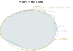
"The geoid approximates mean sea level. The shape of the ellipsoid was calculated based on the hypothetical equipotential gravitational surface. A significant difference exists between this mathematical model and the real object. However, even the most mathematically sophisticated geoid can only approximate the real shape of the earth."
1-Mean Sea Level, GPS, and the Geoid
Last edited by FlightPathOBN; 27th March 2011 at 03:10. Reason: add image
Joined: Jun 2007
Posts: 247
Likes: 0
From: Aberdeen
even more flattened then, and what on earth - no, l won`t go there - would happen if it landed on an integer ?
dark stars are difficult enough thankyou !
please don`t think for a moment that l have a clue what l`m talking about
dark stars are difficult enough thankyou !
please don`t think for a moment that l have a clue what l`m talking about