So what is the % difference between reality and the WGS84 model?
The difference varies. The WGS model still approximates the earth surface curvature..
Also: As of the latest revision, the WGS 84 datum surface is defined as an oblate spheroid (ellipsoid), with major (transverse) radius a = 6,378,137 m at the equator and flattening f = 1/298.257223563.[6] The polar semi-minor (conjugate) radius b can be derived by b = a (1 - f) ≈ 6356752.3142 m.[7] (This is a flattening of 21.384 685 755 km, or ≈ 0.335% in relative terms).
Presently WGS 84 uses the 1996 Earth Gravitational Model (EGM96) geoid, revised in 2004.
The gravitational model will be thrown off on areas that are in large, very high, so the 'model' will bulge inward (higher) in mountainous areas. The ocean surface tends to flatten out, so the model appear to bulge outward...
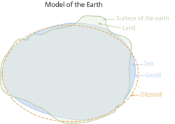
"The geoid approximates mean sea level. The shape of the ellipsoid was calculated based on the hypothetical equipotential gravitational surface. A significant difference exists between this mathematical model and the real object. However, even the most mathematically sophisticated geoid can only approximate the real shape of the earth."
1-Mean Sea Level, GPS, and the Geoid