


AF 447 Search to resume

Per Ardua ad Astraeus
Joined: Mar 2000
Posts: 18,575
Likes: 4
From: UK
Nach Fussball, Dennis - I cannot for the life of me see why those 'extrapolations' are of any value. They take NO account of the 02:10 ACARS reported position, and show an 'Acars position' at 02:15 which I thought there was not?

Thread Starter
Joined: Jan 2008
Posts: 1,275
Likes: 21
From: London
It would seem the 2:15 extrapolation is just that, an extrapolation, which with the current info on the possible location of (one of the) recorders it would seem prudent to completely disregard....
Fab analysis by fab committed people (football or not), I am most impressed!!
Thank you all!
Fab analysis by fab committed people (football or not), I am most impressed!!
Thank you all!
Joined: Jun 2009
Posts: 691
Likes: 0
From: Paris
Hi BOAC,
You are right about that. Tim Vasquez's weather analysis was pretty interesting at some point because it was made few days after the crash but his data on flight plans were not updated with later infos from BEA. As far as your question is concerned, F-GZCP positional report was sent automatically every 10 mn, and the last one was stamped at 02.10. If you want to see the details of the flight plan, look here at the BEA/m�t�o France animated map:
Flight Paths of Flight AF 447 and of the flights that crossed the zone around the same time
This animation is really interesting as:
a) 4 flights (including 3 from Air France) are diverting around the thunderstorm; particularly AF 459, on the same track but behind AF 447.
b) AF 447 is going head on into the storm zone, same for ELY 010 but on the westerly track which seems much less dangerous.
As for AF 447 positions recorded from 0100 to 0210:
0210: 02�58'47"N 30�35'23"W
0200: 01�48'00"N 31�08'59"W
0150: 00�38'23"N 31�45'36"W
0140: 00�29'23"S 32�22'11"W
0130: 01�38'59"S 32�58'47"W
0120: 02�49'11"S 33�36'35"W
0110: 04�01'11"S 34�14'24"W
0100: 05�12'35"S 34�52'11"W
As for theoretical position at 0215, it can be infered from the last flight segment 0200-0210 at an average speed of 473 knots in direction of TASIL: 39.5 nautical miles further.
Positon given by mm43 for Seabed Worker's search area is (was yesterday):
2�42'37"N 31�12'36"W
This point is 41 nautical miles from 0210 position (last report) but on the other way, in direction of Brazilian coast.
S~
Olivier
Originally Posted by BOAC
I cannot for the life of me see why those 'extrapolations' are of any value. They take NO account of the 02:10 ACARS reported position, and show an 'Acars position' at 02:15 which I thought there was not?
Flight Paths of Flight AF 447 and of the flights that crossed the zone around the same time
This animation is really interesting as:
a) 4 flights (including 3 from Air France) are diverting around the thunderstorm; particularly AF 459, on the same track but behind AF 447.
b) AF 447 is going head on into the storm zone, same for ELY 010 but on the westerly track which seems much less dangerous.
As for AF 447 positions recorded from 0100 to 0210:
0210: 02�58'47"N 30�35'23"W
0200: 01�48'00"N 31�08'59"W
0150: 00�38'23"N 31�45'36"W
0140: 00�29'23"S 32�22'11"W
0130: 01�38'59"S 32�58'47"W
0120: 02�49'11"S 33�36'35"W
0110: 04�01'11"S 34�14'24"W
0100: 05�12'35"S 34�52'11"W
As for theoretical position at 0215, it can be infered from the last flight segment 0200-0210 at an average speed of 473 knots in direction of TASIL: 39.5 nautical miles further.
Positon given by mm43 for Seabed Worker's search area is (was yesterday):
2�42'37"N 31�12'36"W
This point is 41 nautical miles from 0210 position (last report) but on the other way, in direction of Brazilian coast.
S~
Olivier
Last edited by takata; 8th May 2010 at 19:31.

Joined: Mar 2010
Posts: 67
Likes: 0
From: Sweden
FM vs GPS position
Denis and others.
The first accident reports states the following:
"The first position message (AOC type message) was transmitted on 31 May at
22 h 39. On 1st June at 2 h 10 min 34, the last position received was latitude
+2.98� (North) and longitude -030.59� (West). The position transmitted was the
aircraft�s FM position which, in normal conditions, is close to the GPS position."
I am unsure how exact the FM position is compared to a "real" GPS position.
Could this explain the differences in assumed final position and current search area?

Joined: Jun 2009
Posts: 1,330
Likes: 0
From: NNW of Antipodes
Update: "Seabed Worker" - positions
Thanks again to broadreach and apologies for the delay (sleep!), here are the latest available positions for the "Seabed Worker".
8 May 2010 00:30z Hdg 249.3 Spd 0.6 2�44'10''N 31�15'57''W
7 May 2010 22:44z Hdg 330.3 Spd 2.5 2�41'36''N 31�14'23''W
7 May 2010 21:08z Hdg 221.6 Spd 0.5 2�41'41''N 31�13'40''W

The vessel is moving around slowly, and it appears that the AUVs may be down, but programed to make short runs. With the position data being delayed and in limited supply, it is not that easy to determine what is going on, other than to say that I believe a small debris field is being investigated.
The "Seabed Worker" has remained within the cyan (light blue) bordered box since arriving at this location.
mm43
8 May 2010 00:30z Hdg 249.3 Spd 0.6 2�44'10''N 31�15'57''W
7 May 2010 22:44z Hdg 330.3 Spd 2.5 2�41'36''N 31�14'23''W
7 May 2010 21:08z Hdg 221.6 Spd 0.5 2�41'41''N 31�13'40''W
The vessel is moving around slowly, and it appears that the AUVs may be down, but programed to make short runs. With the position data being delayed and in limited supply, it is not that easy to determine what is going on, other than to say that I believe a small debris field is being investigated.
The "Seabed Worker" has remained within the cyan (light blue) bordered box since arriving at this location.
mm43
Joined: Jun 2009
Posts: 38
Likes: 0
From: Hamburg, Germany
Found this in the pprune.org-archive from user kijangnim on 26.JAN-2010 at 13.58h in Tech Log, A320 FM Position...
Denis
Denis
1.1.1 THE NAVIGATION FUNCTION
A glance at some Bits and pieces
1.1.1.1 The IRS:
The
IRS is the only navigation system which qualifies as a �SOLE
Mean of Navigation
� system, because it has availability, integrity,
and continuity.
Therefore the IRS will be the absolute reference for the FM, when
position and velocity has to be acquired.
1.1.1.2 IRS and GPS
If GPS has successfully passed all the tests, then the IRS position
and velocity data will be blended with the GPS position.
The result represents what we refer to as RAW data, this raw data is
acquired by the FM through the FG, in order to be used for position
computation.
If the GPS is not available, then the IRS will still provide position and
velocity raw data, however they are Inertial only data.
1.1.1.3 Kalman Filtering
Kalman filtering is a technique implemented in the FM, and applied
by the FM in order to compensate for IRS error.
As we know, IRS error grows with time.
It is interesting to note that as far as IRS versus GPS precision is
concerned, the IRS is less precise in long term but more precise in
short term.
The FM will compare the position obtained by the GPS (or computed
using Radio update), with the IRS raw position, the difference will be
translated into an error, and fed to the Kalman filter.
The Kalman filter will use the error and apply a correction based
either on the frequency or the statistical occurrence of that error.
1.1.1.4 The Earth Model
The FM uses a simplified Earth model (WGS-84), and despite the
fact that it is accurate enough, it will still generate a small difference
in position with respect to where the FM �thinks� it is, versus where
the FM really is on Earth.
1.1.1.5 Trajectory representation
We have to remember that tracks, and courses are straight lines,
which is the way a great circle is represented on a Lambert conformal
chart.
1.1.2 COMPUTATION OF POSITION
1.1.2.1 The FM position computation:
1.1.2.1.1 Using IRS RAW DATA
As per Airbus philosophy based on system segregation, each
FM is using all three IRSs raw data inputs to obtain the
Inertial Position and Velocity, along with onside inputs from
Air Data.
The FM will apply the KALMAN FILTERING Technique to each
IRS in order to obtain a Corrected IRS Position and Velocity.
The FM will then compute the mean weighted average of the
three corrected IRS position and velocity to obtain a
corrected MIX IRS position and velocity.
The Corrected MIX IRS Position is then used by the FM as the
Aircraft position, this position also refers to the �FM position�
1.1.2.1.2 Using GPS Data
If GPS has successfully passed all the tests, then the FM will
use the GPS position to elaborate the error model, and feed
the Kalman filter with it.
1.1.2.1.3 Using Radio Navigation Data
If Radio Nav has successfully passed all the tests:
The same process described above is performed using
DME/ DME or VOR/DME, and the same results will
be obtained, however with a greater EEEssstttiiimaaattteeeddd
PPPooosssiiitttiiiooonnn UUUnnnccceeerrrttaaaiiinnntttyyy.
Further more, the FM through the navigation function
provides current aircraft state information consisting of
Present Position
Altitude
Wind
True Airspeed
Ground Speed
True and Magnetic Heading
True Track Angle.
1.1.2.2 SENSORS SPECIFICS:
The sensor selection is based on a precision criteria classified as
follows:
GPS
RHO/RHO, DME/DME
VOR/DME
MIXed IRS
and so on and so on So manyway to explain thing, there is no best one no worst one, the aim is to be understood
Joined: Jun 2009
Posts: 1,330
Likes: 0
From: NNW of Antipodes
originally posted by DenisG...
Further more, the FM through the navigation function provides current aircraft state information consisting of
Present Position
Altitude
Wind
True Airspeed
Ground Speed
True and Magnetic Heading
True Track Angle.
Further more, the FM through the navigation function provides current aircraft state information consisting of
Present Position
Altitude
Wind
True Airspeed
Ground Speed
True and Magnetic Heading
True Track Angle.
mm43
Joined: Mar 2010
Posts: 67
Likes: 0
From: Sweden
DenisG
Many thanks for the rapid and rather complete info.
I will try to analyze it to my best ability. One question still remains - the IR-fault messages by ACARS could indicate that there perhaps has been one or two faulty/erroneous/rejected IRS position signals.
Since last summer I have also been assembling some info on examples of malfunctions in BITE systems - which seems to occur but rather seldom.
Last edited by Diversification; 8th May 2010 at 21:28.
Joined: Jun 2009
Posts: 1,330
Likes: 0
From: NNW of Antipodes
Update: "Seabed Worker" - positions
The latest available positions, thanks to broadreach, follow:-
8 May 2010 12:45z Hdg 074.9 Spd 10.2 2�40'37"N 31�13'44"W
8 May 2010 11:01z Hdg 154.5 Spd 00.4 2�40'55"N 31�14'27"W
8 May 2010 09:19z Hdg 181.9 Spd 00.5 2�41'37"N 31�14'29"W
Indications are that the AUVs are still in use.
mm43
8 May 2010 12:45z Hdg 074.9 Spd 10.2 2�40'37"N 31�13'44"W
8 May 2010 11:01z Hdg 154.5 Spd 00.4 2�40'55"N 31�14'27"W
8 May 2010 09:19z Hdg 181.9 Spd 00.5 2�41'37"N 31�14'29"W
Indications are that the AUVs are still in use.
mm43
Joined: Jul 2009
Posts: 1,682
Likes: 0
From: France - mostly
Cabin v/s Adisory
Originally Posted by takata;#882
You meant this one?
ADVISORY CABIN VERTICAL SPEED (2 h 14) - received: 02:14:26
Actually it does not exactly say that the aircraft was descending (or climbing). This ACAR is pointing at cabine regulation system.
ADVISORY CABIN VERTICAL SPEED (2 h 14) - received: 02:14:26
Actually it does not exactly say that the aircraft was descending (or climbing). This ACAR is pointing at cabine regulation system.
yes, I meant that one. BEA's 1st Interim report states it meaning as:
Meaning: This message indicates a cabin altitude variation greater, as an absolute value, than 1,800 ft/min for five seconds.
EDIT:: For structural reasons, the cabin pressurization system cannot allow the pressure inside the cabin to be less than the outside pressure. When that happens, the outside pressure will equalize the cabin, which then descends at the same rate as the aircraft.
HN39
Last edited by HazelNuts39; 8th May 2010 at 21:57. Reason: as indicated
Joined: Mar 2010
Posts: 67
Likes: 0
From: Sweden
DenisG and others,
It seems from the posted info that Airbus is using its three ADIR units to provide three separate IRS positions. Probably these are then compared with a "dead-reckoned" new position obtained from time and speed. These two pairs of the three positions are then apparently used with Kalman filtering to obtain a new adjusted position. I don't know how three possibly different corrected position values are handled. I assume than one or more of these were in error due to the errors in the speed measurements, which may have grown slowly over time. In my personal opinion, this may well explain why the transmitted FM-position perhaps was more and more off from the correct position near the end of the flight.
Any comments?
Joined: Jun 2009
Posts: 1,330
Likes: 0
From: NNW of Antipodes
The original scenario associated with the drawing of the following graphic was outlined in a post to the AF447 thread back in September 2009. However, things have changed and I now propose the following:-
1. Loss of control on penetrating an active mesoscale event.
2. Pitot icing was rapid rather than gradual on account latent heat in updraughts.
3. Overspeed occured.
4. Recovery failed when penetration of a second mesoscale event took place NNW of ORARO.
5. Cabin Vertical Speed was following flameout and stall.
Now that's plenty to keep you going, and here is the graphic:-

mm43
1. Loss of control on penetrating an active mesoscale event.
2. Pitot icing was rapid rather than gradual on account latent heat in updraughts.
3. Overspeed occured.
4. Recovery failed when penetration of a second mesoscale event took place NNW of ORARO.
5. Cabin Vertical Speed was following flameout and stall.
Now that's plenty to keep you going, and here is the graphic:-
mm43
Joined: Jun 2009
Posts: 1,344
Likes: 80
From: Bedford, UK
Inertial and GPS
Inertial gives position, acceleration and velocity vector continuously. GPS gives position only unless speed is derived from position (inertial derives speed from acceleration). Both have some issues with respect to height - inertial has undamped errors which may require assistance from air data, GPS has to derive height from an earth centric smoothed ellipsoid. Would expect the kalman filter to be primarily blending air data height, and GPS position, with the base IRS model in order to continuously refine the IRS errors sources and for the enhanced IRS output to be the primary source for navigation.

Joined: Mar 2003
Aviation Qualifications: ATPL
Posts: 2,558
Likes: 155
From: BC
Diversification;
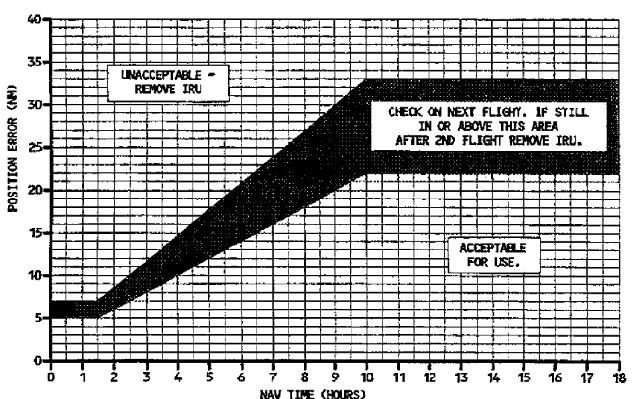
While there are always errors slowly introduced in the IRS calculations, the flight was only into its 3rd hour. Unless an IRS began failing, IRS drift and therefore the calculated bias to produce mixed position would be quite small. The most drift have ever seen in years of overseas flying on the A330/A340 was in the neighbourhood of 20nm. We can see by the chart that a nominal drift at 3 to 4hrs into the flight could possibly be around 7 to 12nm or so and that would be significant. In reality the drift is usually far less. The IRS position bias is updated by radio or GPS but the original IRS calculated positions are not so updated. I am assuming that FMS position errors would always be less than IRS errors.
PJ2
I assume than one or more of these were in error due to the errors in the speed measurements, which may have grown slowly over time. In my personal opinion, this may well explain why the transmitted FM-position perhaps was more and more off from the correct position near the end of the flight.
PJ2

Joined: Jan 2008
Posts: 2,173
Likes: 51
From: Blighty (Nth. Downs)
Hi DenisG and Diversification,
As someone who�s only following this thread superficially, I�m most impressed by the amount of information that you guys are processing − much of which is going over my head, because I haven�t done enough homework at this stage. But perhaps I can intrude briefly to suggest that you may not need to get too exercised about the complexities of the various present-positions computed by the FMC to arrive at its PPOS (present position).
To answer one point, IRS positions are themselves a form of dead-reckoning position, based on the departure position (while stationary), modified by all subsequent accelerations. While the systems were up and running, the three IRS positions are unlikely to have been much apart from either the true position, or each other, after the short flight time (3 hours?). The Mix-IRS position was therefore unlikely − in my opinion − to be more than about 2 nm in error; probably less.
Radio Position updating can only be better than that if a suitable pair of ground-based DME (distance-measuring) stations are available. This would not have been the case, as they are only receivable up to about 200nm at cruising altitudes. So, as is usual over desert and ocean, no Radio Position would have been available for consideration by the FMC.
The most accurate positioning system is, of course, (dual?) GPS. The chances are that it would have been available, and giving a far more accurate position than the Mix-IRS Position. But even if it was not, the FMC position would still have been accurate to within about 2nm. As PJ2 now indicates, the FMC PPOS should be slightly better than Mix-IRS, because it would have incorporated a correction (bias) to it during earlier periods when Radio or GPS Positions were available. So the FMC PPOS is likely to have been accurate to within 2nm while the FMC and IRSs remained powered and serviceable.
In the unlikely event that ACARS happened to transmit a PPOS just before impact, that position should have been accurate enough to send search vessels to the right area. The problem some of you seem to be pursuing is: how far did the flight continue after the last ACARS-transmitted position, and in what direction?
Chris
Joined: Jun 2009
Posts: 38
Likes: 0
From: Hamburg, Germany
Hi folks.
Hi takata.
You mentioned 473 knots between position at 02.00h and LKP (last known position). I got a slightly different result, but mine was done on paper with a pen... I guess you have more accurate data?
(1) What is the distance between position at 02.00h and LKP?
(2) What is the distance between INTOL and LKP?
(3) Do we know when they passed INTOL? BEA (JUL-09,p.41) states 01.33h.
(4) What speed was reported at INTOL?
Denis
My estimates:
(A) INTOL (01.33h)-LKP(02.10h) 550km - 37min - 481 knots
(B) INTOL (01.33h)-P(02.00h) 404km - 27min - 481 knots
(C) P(02.00h)-LKP(02.10h) 144km -10,5min - 466 knots
But this is way too unprecise too derive anything from this; one would need much more accurate data.
Denis
Last edited by DenisG; 9th May 2010 at 01:53.
Joined: Jun 2009
Posts: 38
Likes: 0
From: Hamburg, Germany
1. Loss of control on penetrating an active mesoscale event.
2. Pitot icing was rapid rather than gradual on account latent heat in updraughts.
3. Overspeed occured.
4. Recovery failed when penetration of a second mesoscale event took place NNW of ORARO.
5. Cabin Vertical Speed was following flameout and stall.
2. Pitot icing was rapid rather than gradual on account latent heat in updraughts.
3. Overspeed occured.
4. Recovery failed when penetration of a second mesoscale event took place NNW of ORARO.
5. Cabin Vertical Speed was following flameout and stall.
Sounds reasonable. Would you assume the a/c to have been at FL350 still at time of LKP?
Even if the generally estimated 4 minutes from LKP to impact might be inaccurate, at 7 minutes that would still be a decline rate of 5,000 feet per minute. While making a left bank between 35� and 50� at >607knots (!) (based on 75km from LKP to search area in 4minutes). And then impacting pitch-up, slight bank? - without maydays? Wouldn't there be specific injuries detectable on the bodies at a decline rate like that? Would the crew not have been ordered to caution position before entering MCS at ORARO, as they already passed a little one at SALCU?
Denis
Joined: Jun 2009
Posts: 691
Likes: 0
From: Paris
Hello Hazelnuts39,
Right, but what it means is that pressure varied, no more.
First, I didn't say that cabin was depressurized as I've read also the BEA reports and I'm fully aware that it is mentioned that no depressurization ever occured. What I'm saying is that everything is linked with frozen probes while many people around are just evacuating this factor for making wide assumptions about the flying conditions.
Consequently, variations of measured pressure are assumed to be the cause of cabin regulation issue. My opinion is that those variations are not the result of actual (real) pression difference. All systems that are going off, including this one, are feeded by unreliable informations comming from frozen probes.
I'm not assuming that F-GZCP's speed, altitude, pressures informations were still reliable after 02.10 when it is proved that they were not due to ice buildup. I'm not assuming that this aircraft was flying instantaneously below 14,000 ft near Mach 1, neither that she was instantaneously sinking at a rate of 8,000-9,000 ft because I firmly believe that it was simply the result of the root problem.
I'm not going to invent more issues than what is plainly documented as the primary root for many ACARS saying the same thing and which is ICE buildup. Furthermore, I'm also convinced that icing conditions were particularly severe and unusual due to the length of the convective zone crossed. It means that F-GZCP was certainly flying over huge tropical thunderstorms during about 15 minutes and that icing problems showed up after 2/3rd of the crossing.
Feel free to believe something else yourself but, please, do not contradict my points by ignoring this ICE issue. Furthermore, it is certainly possible to assume that problems with ICE did not end up there and that it could have caused dual engine flameouts when F-GZCP's ACARS transmission stopped.
In fact, my explanation is the simpliest possible: one factor, ICE, is identified and I certainly believe that it can bring this aircraft down all by itself, by accumulative effect. Each of those ICE related issues, taken one by one, were not such a big deal to be resolved by the crew but their accumulation in a short time, like a cascade, could have caused a final situation totally umbearable by the crew in this particular environment.
S~
Olivier
Originally Posted by HazelNuts39
takata;
yes, I meant that one. BEA's 1st Interim report states it meaning as:
As reported in its 2nd interim report, BEA has established that depressurization did not occur, therefore the Advisory means that the cabin was descending. That means that the airplane was descending, and that it was descending at a greater rate than the cabin pressuration system could cope with. Since cabin altitude in cruise is typically around 8000 - 9000 ft, I imagine that the Advisory probably means that the airplane was descending through an altitude in that range.
EDIT:: For structural reasons, the cabin pressurization system cannot allow the pressure inside the cabin to be less than the outside pressure. When that happens, the outside pressure will equalize the cabin, which then descends at the same rate as the aircraft.
yes, I meant that one. BEA's 1st Interim report states it meaning as:
Quote:
Meaning: This message indicates a cabin altitude variation greater, as an absolute value, than 1,800 ft/min for five seconds.
Meaning: This message indicates a cabin altitude variation greater, as an absolute value, than 1,800 ft/min for five seconds.
EDIT:: For structural reasons, the cabin pressurization system cannot allow the pressure inside the cabin to be less than the outside pressure. When that happens, the outside pressure will equalize the cabin, which then descends at the same rate as the aircraft.
First, I didn't say that cabin was depressurized as I've read also the BEA reports and I'm fully aware that it is mentioned that no depressurization ever occured. What I'm saying is that everything is linked with frozen probes while many people around are just evacuating this factor for making wide assumptions about the flying conditions.
Consequently, variations of measured pressure are assumed to be the cause of cabin regulation issue. My opinion is that those variations are not the result of actual (real) pression difference. All systems that are going off, including this one, are feeded by unreliable informations comming from frozen probes.
I'm not assuming that F-GZCP's speed, altitude, pressures informations were still reliable after 02.10 when it is proved that they were not due to ice buildup. I'm not assuming that this aircraft was flying instantaneously below 14,000 ft near Mach 1, neither that she was instantaneously sinking at a rate of 8,000-9,000 ft because I firmly believe that it was simply the result of the root problem.
I'm not going to invent more issues than what is plainly documented as the primary root for many ACARS saying the same thing and which is ICE buildup. Furthermore, I'm also convinced that icing conditions were particularly severe and unusual due to the length of the convective zone crossed. It means that F-GZCP was certainly flying over huge tropical thunderstorms during about 15 minutes and that icing problems showed up after 2/3rd of the crossing.
Feel free to believe something else yourself but, please, do not contradict my points by ignoring this ICE issue. Furthermore, it is certainly possible to assume that problems with ICE did not end up there and that it could have caused dual engine flameouts when F-GZCP's ACARS transmission stopped.
In fact, my explanation is the simpliest possible: one factor, ICE, is identified and I certainly believe that it can bring this aircraft down all by itself, by accumulative effect. Each of those ICE related issues, taken one by one, were not such a big deal to be resolved by the crew but their accumulation in a short time, like a cascade, could have caused a final situation totally umbearable by the crew in this particular environment.
S~
Olivier
Last edited by takata; 9th May 2010 at 06:59.