


MH370 Found in the Indian Ocean?

Moderator
Thread Starter
MH370 Found in the Indian Ocean?
https://7news.com.au/sunrise/on-the-...ough-c-4765991
Second opinion (for what it is worth?)
https://www.airlineratings.com/news/...nary-tracking/
Second opinion (for what it is worth?)
https://www.airlineratings.com/news/...nary-tracking/

Nunc est bibendum
Having seen how he tracked a couple of my own flights I can see some value.
In both cases he was given a departure point (outside of Australia, outside of both radar and ADSB), an initial heading, but not an arrival port. In both cases he was able to accurately to show not just where we landed (two very different ports) but also our arrival time with an accuracy of a couple of minutes. His enroute ETAs were all within a couple of minutes of ours also.
It’s better than throwing darts in a map and seems to be much better than a ouija board.
Mr Godfrey may have pulled off an Inspector Clouseau.
His bumbling flightpath from Penang involving a holding pattern, multiple turns, speed and altitude changes, actually ends near the constant magnetic heading ghost flight from Banda Aceh via NILAM-SANOB (191M/FL360/250KIAS with left systems inoperative).
It passes every satellite arc on time and ends near the 7th arc around 34S93.5E
Pity Malaysia is not interested.
Having seen how he tracked a couple of my own flights I can see some value.
In both cases he was given a departure point (outside of Australia, outside of both radar and ADSB), an initial heading, but not an arrival port. In both cases he was able to accurately to show not just where we landed (two very different ports) but also our arrival time with an accuracy of a couple of minutes. His enroute ETAs were all within a couple of minutes of ours also.
It�s better than throwing darts in a map and seems to be much better than a ouija board.
There is limited ADS-B data for that flight that shows that of the seven position indicators that there's good data for none of his fixes came within 30 km of the target aircraft's position with the error growing to nearly 70 km toward the end of the first two hours. The smallest error recorded exceeded his sampling rate of 2 minutes; that's not good.
He was basically making educated guesses of the aircraft's location based on the departure time, known airways, known aircraft performance (eg actual fuel load, climb and cruise speeds) and weather courtesy of Nullschool.
If you look at the track that he has plotted for MH370 he has the aircraft doing a coast hugging tour of north-western Sumatra before entering a 22 minute one lap racetrack south of Indonesia all flown at cruise speed. Does that sound even vaguely likely given what we already know?
Nunc est bibendum
So how did he manage to work out where we landed and at what time? On both those flights? (I’ll have to take your word for it on the call sign, too long ago now to remember).
That was the point of the flights. There was limited ADSB data available and in parts of them we did NOT follow published air routes.
Given that one of them over flew Sydney, how did he know we didn’t land there?
Any thoughts on the blind test of the RNZAF P3 flight? Details of that aren’t on ADSB or flight tracking websites either and yet the tracking is pretty bloody close to what they flew.
I get being sceptical but this appears to have some legs.
There is limited ADS-B data for that flight that shows that of the seven position indicators that there's good data for none of his fixes came within 30 km of the target aircraft's position with the error growing to nearly 70 km toward the end of the first two hours. The smallest error recorded exceeded his sampling rate of 2 minutes; that's not good.
Given that one of them over flew Sydney, how did he know we didn’t land there?
Any thoughts on the blind test of the RNZAF P3 flight? Details of that aren’t on ADSB or flight tracking websites either and yet the tracking is pretty bloody close to what they flew.
I get being sceptical but this appears to have some legs.
They may have done some WSPR trials, but how do they reconcile the major discrepancy between the proposed Sumatra hugging coastline flightpath, and the more reliable Malaysian primary radar data tracking towards NILAM?
I applaud the attempt, but the accuracy of WSPR is very poor.
What is needed is another position fix.
eg any of the withheld Indonesian primary radar recordings at Lhokseumawe, Sabang, or Sibolga.
Or a phone log on at Banda Aceh.
Or a Banda Aceh CCTV with audio recording.
I applaud the attempt, but the accuracy of WSPR is very poor.
What is needed is another position fix.
eg any of the withheld Indonesian primary radar recordings at Lhokseumawe, Sabang, or Sibolga.
Or a phone log on at Banda Aceh.
Or a Banda Aceh CCTV with audio recording.
So how did he manage to work out where we landed and at what time? On both those flights? (I�ll have to take your word for it on the call sign, too long ago now to remember).
That was the point of the flights. There was limited ADSB data available and in parts of them we did NOT follow published air routes.
Given that one of them over flew Sydney, how did he know we didn�t land there?
Any thoughts on the blind test of the RNZAF P3 flight? Details of that aren�t on ADSB or flight tracking websites either and yet the tracking is pretty bloody close to what they flew.
I get being sceptical but this appears to have some legs.
Regards overflying Sydney, he knew that, 'Fuel at takeoff was 48.0 MT of which 4.5 MT was added by the Captain.' That's a lot for the 6.2 hours to Sydney, isn't it? More like what you would need for the nearly 8 hours to Adelaide.
Regards the RNZAF P3 flight, that wasn't a blind test. He had the track data and then mapped it to his WSPRnet links. I'll comment on the sheer number of links that the author proposes shortly but what is notable in the case of the P3 flight is the base rate of anomalous links - nearing 90 percent of the links are anomalous (either frequency shift or SNR shift). According to the author, that indicates that they are being perturbed by something, likely aircraft.
The issue here is that, even if that contention is correct (and it likely is not), the perturbations can't all be down to the target P3. It's a simple statistical matter - put sufficient lines on a map and plot a track in 2 minute increments on the map and at some point the track plot will land on a line. If 90 percent of the lines are anomalous, there's a 9 in 10 chance that you get to say, that anomaly was caused by the target aircraft.
For fear of going on a bit, the history of this "breakthrough technology" is instructive. Using WSPR, that is a weak signal radio connection between two stations, to detect the presence of an aircraft and applying that to MH370 was first proposed Rob Westphal late last year. His work focussed on the short path (that is the most direct great circle propagation path) between the two stations. People were sceptical if WSPR data could be used that way but the notion of relying on the short path was uncontroversial.
The problem that then arose for the current author's work was that there are very few short path links that traverse the Southern Indian Ocean. Undeterred, the author invoked the long path for his work.
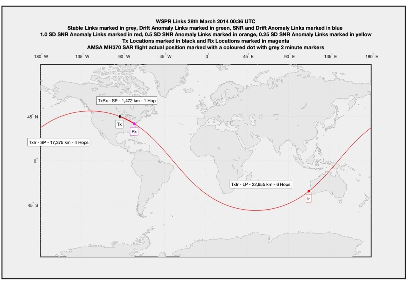
As illustrated above the long path is what's left of the entire great circle when the short path is subtracted. Invoking the long paths provides myriad paths that criss-cross the SIO, the problems being that (a) most of them do not exist (long path connections over the distances invoked by the author are rare) and (b) as there is only one limited data set per each WSPR "spot" (Tx-Rx connection) any perturbation of the long path would be unreadable under the short path.
The sheer nonsense of the author's approach is that he claims both sensitivity and specificity. He variously claims that not only an aircraft on the other side of the world can be detected perturbing the long path transmission but that it can also detect "the wake vortex and a series of small Doppler shifts due to water vapour variations". You might well ask yourself how many "water vapour variations" might impinge on a radio signal that is purportedly travelling 40,000 km around the world!
If that's not bad enough, the author then claims that with that extraordinary sensitivity the technology can discern a specific target on the other side of the world. The fact that many of the Tx Rx stations are near airports doesn't seem to be a concern - potential contamination of the data by other than the target is never mentioned. No one with any understanding of physics, radio and/or radar that I have spoken to thinks that what the author proposes is even remotely possible.
But what the use of long paths does for the author is that it baths areas of interest in path lines that he can use. For the QF6036 example there were at times a long path line on average every 5 km. It's then a simple statistical matter - chance of intersecting a path line X chance of path line being anomalous. The author is essentially invoking order out of sheer randomness.
Join Date: Sep 2001
Location: Australia
Posts: 21
Likes: 0
Received 0 Likes
on
0 Posts
Don't they have the point at which the aircraft turned South? If I was going to do a similar thing I would just enter 90' South and let the aircraft track longitude until it exhausted its gas. I'm sure they looked in that area.
Who insured the captain? Did they pay? Did they dispute anything?
Mr Godfrey believes the plane rests at the base of Broken Ridge, which is an oceanic plateau in an area filled with ravines and an underwater volcano.
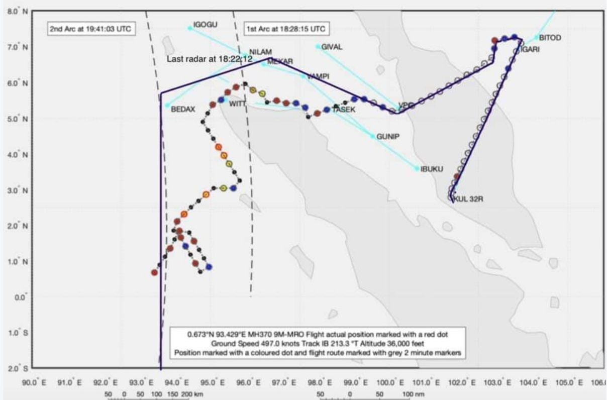
At the last Malaysian primary radar position (1822:12), the aircraft was 10 NM NW of MEKAR tracking NW towards NILAM. My estimate has the aircraft flying from Penang at M0.84/FL360
At 1825:27, approximately 2 NM west of NILAM, the SATCOM logs on. However, the Flight ID was missing (FMC software reset following failure of Left FMC?)
Interestingly, IF the aircraft was flying to Banda Aceh via NILAM and SANOB with an unresponsive crew, then:
At 1825:27, approximately 2 NM west of NILAM, the SATCOM logs on. However, the Flight ID was missing (FMC software reset following failure of Left FMC?)
Interestingly, IF the aircraft was flying to Banda Aceh via NILAM and SANOB with an unresponsive crew, then:
- At the TOPD point for Banda Aceh, the aircraft would slow to the ECON descent speed (250knots for CI 0) while maintaining FL360.
- As the aircraft turns left at NILAM to SANOB, the SATCOM log on coincides with the exact time when the SATCOM switches from the left High Gain Antenna (left inoperative?) to the right High Gain Antenna. The Indian Ocean satellite is now on the right side of the fuselage (track to satellite is approx 261T)
- The aircraft would overfly Banda Aceh maintaining FL360/250KIAS, where it reverts to mag heading. It continues south and passes all satellite arcs on time, IF one auto throttle was inoperative at TOPD (Left A/T inoperative?). Ends near 34S93.5E with flaps retracted. Not fully searched.
So they are saying that it has been found, exactly where is it and the evidence?
I have lost my car keys before, however I only found them when I sighted them with my own eyeballs. I did speculate and procrastinate and all the rest of it before finding the keys, this speculation in my opinion is exactly the same with regards to the report.
Where is the hardcore evidence to suggest where the remains of the aircraft is exactly located?

Join Date: Sep 2015
Location: United Kingdom
Age: 55
Posts: 6
Likes: 0
Received 0 Likes
on
0 Posts
None of us can answer that, but guessing with excellent accuracy is a trick that supposed magicians and psychics have pulled off for many years. In modern times a combination of research on social media and educated guesses along with "tells" from the subject can pull off a remarkable result.
"Oh ye of little faith" this IS where MH370 is!
One only has to listen to one of Australia's most believable experts on Aviation matters to know that it's correct. After all if GT reckons it's there then surely it must be!!!
One only has to listen to one of Australia's most believable experts on Aviation matters to know that it's correct. After all if GT reckons it's there then surely it must be!!!
Join Date: Mar 2015
Location: YYZ
Posts: 7
Likes: 0
Received 0 Likes
on
0 Posts
Pronounced "sigh"
The legislative authority of the Proliferation Security Initiative or PSI, which Obama signed convicted embezzler and former Malaysian PM Najib Razak to, a few weeks after the crash of MH370, specifically allows for the dissemination of disinformation as determined to be strategically necessary for the protection of civil aviation in regards to WMD's and their "transportation systems".
WMD=Guided missile=Hijacked Airliner.
WMD=Guided missile=Hijacked Airliner.

Surely there’s a 50% chance that it is in the Indian Ocean.