


Turkish A330 incident, Kathmandu

Join Date: Jul 2007
Location: Hadlow
Age: 60
Posts: 597
Likes: 0
Received 0 Likes
on
0 Posts
Looking at the photos in the link posted by Airport 30, it's going to have to be fixed at Kathmandu, isn't if? I'd say that would mean it would take a lot longer than would otherwise be the case.

Pegase Driver
Join Date: May 1997
Location: Europe
Age: 74
Posts: 3,686
Likes: 0
Received 0 Likes
on
0 Posts
Capn Bloggs
2D-3D , yes agreed ! What I find very confusing is the multitude of abbreviations basically reffering to the same thing (i.e. 3D, APV, LPV, GBAS, GLS, RNP Precison APP, pseudo ILS, etc..) If everyone would use the term " with vertical guidance " and clearly separating basic GPS navigation from the Nav with augmented systems ( WAAS and EGNOS) instead of using " RNP " for both , things would be a little clearer for everyone I guess.
Back to KTM : the RNAV APP there is a basic GPS one , not with vertical guidance and it is a 2D and non-Precision APP .
Re Training : I was not targeting the crews here, but also the controllers.
Certification is easy, training all staff is more compicated. Throwing a couples of photocopies from a training manual into the lockers can hardly be called training, yet it is sometimes what is done in some places, and not only in the thirld world.
Reading the BEA report I was refering to in post #80, http://www.bea.aero/docspa/2012/f-pe...e120403.en.pdf lack of undertanding the procedure due lack of proper training is highlighted here with multiples incidents by same airline at same airport.
Often both controllers and crews do not see the difference between "offering" an RNAV APP and "instructing" to do one. There lies the source of many problems if you ask me.

Back to KTM : the RNAV APP there is a basic GPS one , not with vertical guidance and it is a 2D
Our CAA rules for conduct of an RNP-AR approach: "After the aircraft has passed the FAP or VIP on an approach, deviation from the defined vertical path must not exceed the limiting value for vertical deviation stated in the operator’s RNP AR operating procedures." = 3D approach.
Note that the minima is a DA; no point in trying to fly to a DA, especially with a vis limit of 900m, if you're flying some sort of pilot-created profile.
Join Date: Nov 1998
Location: netherlands
Posts: 297
Likes: 0
Received 0 Likes
on
0 Posts
ATC Watcher,
Back to KTM : the RNAV APP there is a basic GPS one , not with vertical guidance and it is a 2D and non-Precision APP .
Back to KTM : the RNAV APP there is a basic GPS one , not with vertical guidance and it is a 2D and non-Precision APP .
See: http://www.caanepal.org.np/publicati...12%20Final.pdf
Pegase Driver
Join Date: May 1997
Location: Europe
Age: 74
Posts: 3,686
Likes: 0
Received 0 Likes
on
0 Posts
Capn Bloggs, Sleeper
You are both right, I stand corrected.
from the AIP sup point 2.6 :
What confused me was the fact that the guys at the meeting kept reffering to the 3D in conjunction with the "ground augmented" LVPs APPs.
While it would seem Baro VNAV is indeed part of a 3D APP.
The rest of the AIP sup is interesting too, thanks Sleeper.
from the AIP sup point 2.6 :
The vertical guidance is based on Baro VNAV with GNSS and requires RNAV equipment which uses barometric altimeter input.
While it would seem Baro VNAV is indeed part of a 3D APP.
The rest of the AIP sup is interesting too, thanks Sleeper.
Join Date: Jan 2009
Location: Somewhere over the rainbow
Posts: 73
Received 0 Likes
on
0 Posts
Well, they have already removed "Turkish" from the paint scheme. Is that significant?
Guest
Join Date: Apr 2009
Location: On the Beach
Posts: 3,336
Likes: 0
Received 0 Likes
on
0 Posts
ATC Watcher:
In the U.S. it won't be in your database unless all certification and qualifications have been met.
I would add to the experts take on RNP AR. AB's airplanes that can do RNP AR 0.30 approaches are ready and able to do RNP 0.10. If a pilot flying into VNTK is worried about being offset up to 0.30, he/she can force the FMS to use 0.10. Thus, the 5% probability maximum offset would be 608 feet. An FMS calculated exceedence in excess of RNP 0.10 would alert 'Unable RNP."
And, of course, the RNP AR pilot is always seeing a value for ANP.
What is more interesting is he obligation to follow certain rules to actually perform an RNAV-AR APP :you need certified aircraft, certified and trained crews , a certified airport and trained air traffic controllers . It is not because it is in the aircraft data base that you can use it . And there lies our first problem.
I would add to the experts take on RNP AR. AB's airplanes that can do RNP AR 0.30 approaches are ready and able to do RNP 0.10. If a pilot flying into VNTK is worried about being offset up to 0.30, he/she can force the FMS to use 0.10. Thus, the 5% probability maximum offset would be 608 feet. An FMS calculated exceedence in excess of RNP 0.10 would alert 'Unable RNP."
And, of course, the RNP AR pilot is always seeing a value for ANP.
Join Date: May 2010
Location: europe
Age: 67
Posts: 645
Likes: 0
Received 0 Likes
on
0 Posts
Judging by this thread those who dreamt up, designed, drew the charts, named the procedures, certified them, trained for their use and worked in ATC to control aircraft equipped to use this new technology have actually increased the margin for error because so few of those who use it haven't for a clue of what it is all about!
If ever there was a topic that needed a clear and unambiguous explanation and training material, this for sure must be one. Jesus, I don't even understand the naming conventions associated with RNP, but I'm still permitted to fly the approaches!
If ever there was a topic that needed a clear and unambiguous explanation and training material, this for sure must be one. Jesus, I don't even understand the naming conventions associated with RNP, but I'm still permitted to fly the approaches!
Join Date: Feb 2013
Location: Quantum vacuum
Posts: 15
Likes: 0
Received 0 Likes
on
0 Posts
Honeywell presentation on an RNAV Approach with LPV Minimums
Guest
Join Date: Apr 2009
Location: On the Beach
Posts: 3,336
Likes: 0
Received 0 Likes
on
0 Posts
deefer dog:
I can only speak for the U.S. The training, avionics familiarity, simulator time, and line qualifications makes any pilot quite conversant in all aspects of RNP AR. And, the RNP AR IAPs are a separate database the Jeppesen, etc, will not provide for the aircraft until the requirements are met. The FAA is very insistent that all the squares be filled it correctly.
If ever there was a topic that needed a clear and unambiguous explanation and training material, this for sure must be one. Jesus, I don't even understand the naming conventions associated with RNP, but I'm still permitted to fly the approaches!
Join Date: Mar 2014
Location: Brussels
Posts: 131
Likes: 0
Received 0 Likes
on
0 Posts
Capt blogs
The new descriptions are 2D and 3D approaches;
2D being lateral guidance only (VORs, NDBs, RNP APCH eg RNAV (GNSS) )
3D, being lateral and vertical guidance eg ILS, MLS, GLS, RNP APCH LNAV/VNAV, LPV and RNP-AR.
The new descriptions are 2D and 3D approaches;
2D being lateral guidance only (VORs, NDBs, RNP APCH eg RNAV (GNSS) )
3D, being lateral and vertical guidance eg ILS, MLS, GLS, RNP APCH LNAV/VNAV, LPV and RNP-AR.
The KTM approach is a GNSS with baro vertical guidance (but called here RNAV RNP). As ATC Watcher said, the confusing terminology does not help here - with many different acronyms for the same type of approach, that do not exactly explain the differences between them (RNP-AR, RNAV RNP, GPS RNAV, GNS, GNSS, GLS).
And sorry, but this GNS debate is relevant to this thread. I know several companies whose pilots were all doing GNSS approaches last year, even though the company had no certification, the Part A had no information, and the pilots had no training. Not saying that is what happened here, but there is definitely a regulatory lacuna here.
It could also be a factor if the training that was given did not point out that GNSS is only a non-precision approach. It would appear that many posters even on this thread, thought that GNSS was a precision approach. So the first time the GNSS approach displaces you 0.25 nm left or right of the centerline might come as a bit of a shock. This is why I questioned the 350' decision at KTM, because this seems a bit low for a possible 0.25 nm displacement.
Oh and as an aside WAAS is a GBAS, it is just that the signals are relayed via standard comms satellites, because it is a wide angle system (a large area system) and not a local system. So what I said is correct - the WAAS system itself is a ground based system and NOT a satellite based augmentation system. (How can a geostationary satellite augment a low-earth orbit satellite?
 ) See the quote below.
 Quote:
The Wide Area Augmentation System (WAAS) uses a system of ground stations to provide corrections to the Global Positioning System navigation signal. A network of precisely surveyed ground-based WAAS wide-area reference stations is strategically positioned across the country including Alaska, Hawaii, Puerto Rico, Canada, and Mexico to collect GPS satellite data...
GNSS Frequently Asked Questions - WAAS
GNSS Frequently Asked Questions - GBAS
The links posted previously in this thread are confusing in their terminology - as is most of the terminology used in these systems. The distinction should be between WAAS and LAAS, and not between WAAS and GBLS. Both WAAS and LAAS are GBLS systems (ie: ground based augmentation systems) - it is just the former is a wide area system via satellite and the latter is a local area system via VHF. But it is true that WAAS and LAAS are not compatible, because they receive the ground-based corrections via different antennae.
Oh, and Capt Blogs. Do you now understand that the orbits of the GPS satellites are fixed? The last time you responded by saying: "You can't be serious...". Do you understand how the system works now? You have gone quiet all of a sudden.
And when I said that GNSS is non-precision (because of its low 0.3nm lateral precision, even though it has vertical guidance), you ridiculed that assertion. But now you respond with: "For goodness sake! WAAS gives better accuracy ... That is all!" Hmm, I think you will find that is what I have been saying from day one, but you did not understand the limitations of the system you are using.
GNSS is a non-precision 3-D landing system.
GNSS plus WAAS-LAAS is a precision 3-D landing system.
And GNSS plus a WAAS-LAAS is a GLS (err, usually). But the terminology is very imprecise here. Since the WAAS and the LAAS have different receivers, they should clearly notate the different approaches to reflect this - something like GLS-W and GLS-L. Or even better, just have GNSS, GNSS-W and GNSS-L.
I hope that is clear - sort of.
Last edited by silvertate; 19th Mar 2015 at 01:23. Reason: typo, and bolding
Join Date: Mar 2014
Location: Brussels
Posts: 131
Likes: 0
Received 0 Likes
on
0 Posts
Sleeper
It is a fullblown 3d , as you call it, rnp ar approach with a 2.8 degree glidepath.
See: http://www.caanepal.org.np/publicati...12%20Final.pdf
It is a fullblown 3d , as you call it, rnp ar approach with a 2.8 degree glidepath.
See: http://www.caanepal.org.np/publicati...12%20Final.pdf
Originally Posted by Silvertate
And GNSS plus a WAAS-LAAS is a GLS (err, usually).
Originally Posted by Sleeper
It is a fullblown 3d , as you call it, rnp ar approach with a 2.8 degree glidepath.
Originally Posted by Silvertate
Interesting, because the approach plate displayed earlier in this thread does not say that (no mention of -AR on the plate). It is May '14, so not sure if it has been updated or not. More problems with naming conventions?
GNSS is a non-precision 3-D landing system.
GNSS plus WAAS-LAAS is a precision 3-D landing system.
GNSS plus WAAS-LAAS is a precision 3-D landing system.
Satellite positions/orbits/rotations are irrelevant; RAIM predictions take that into account, including planned outages. I assume you have been doing RAIM predictions before launching for Turkey and the RNAV (GNSS) you do at Dalaman?
I will agree with ATC Watcher and Deefer Dog that to the untrained eye, the naming convention for RNP approaches is confusing. An RNAV (GNSS) is actually now an RNP APCH LNAV and an RNAV (RNP) is actually an RNP AR APCH. I don't know what the solution is, though. Here, most GNSS' are RNAV-Z and RNP-ARs are RNAV- (insert other letters eg M, U, P).
The only reason I've been quiet is because you haven't been posting furphies recently...
Join Date: May 2010
Location: europe
Age: 67
Posts: 645
Likes: 0
Received 0 Likes
on
0 Posts
Only another 7 years of confusion remaining!
International Civil Aviation Organization
Performance Based Navigation Sub-Group (PBN SG)
First Meeting
(Cairo, Egypt, 1 - 3 April 2014)
The meeting may wish to note that the amendment regarding the conversion of area navigation (RNAV) approach procedure depiction to required navigation performance (RNP) in the PANS-OPS, Volume II is required to align charts with the PBN navigation specifications thereby reducing confusion on operation approvals and flight planning requirements. A one-step eight-year transition period, starting 13 November 2014, is being proposed......
Performance Based Navigation Sub-Group (PBN SG)
First Meeting
(Cairo, Egypt, 1 - 3 April 2014)
Guest
Join Date: Apr 2009
Location: On the Beach
Posts: 3,336
Likes: 0
Received 0 Likes
on
0 Posts
Silvertate:
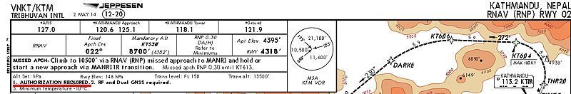
Interesting, because the approach plate displayed earlier in this thread does not say that (no mention of -AR on the plate). It is May '14, so not sure if it has been updated or not. More problems with naming conventions?
WAAS consists of multiple ground reference stations positioned across the U.S. that monitor GPS satellite data. Two master stations, located on either coast, collect data from the reference stations and create a GPS correction message. This correction accounts for GPS satellite orbit and clock drift plus signal delays caused by the atmosphere and ionosphere. The corrected differential message is then broadcast through 1 of 2 geostationary satellites, or satellites with a fixed position over the equator. The information is compatible with the basic GPS signal structure, which means any WAAS-enabled GPS receiver can read the signal.
WAAS is a satellite based augmentation system
EGNOS is a satellite based augmentation system (ICAO definition)
SBAS is a wide coverage augmentation system in which the user receives augmentation information from a satellite based transmitter (ICAO definition)
WAAS is a satellite based augmentation system
EGNOS is a satellite based augmentation system (ICAO definition)
SBAS is a wide coverage augmentation system in which the user receives augmentation information from a satellite based transmitter (ICAO definition)
