


BE1900 IMC CFIT in Alaska

Join Date: Feb 2006
Location: USA
Posts: 487
Likes: 0
Received 0 Likes
on
0 Posts
No, the inner TAA area is 4 n.m. in the straight-in TAA area (the north side). - so if I have this right, on these 'new' RNAV charts, the min hold alt will always be the lowest of the TAA values? NB I have never flown one of these procedures, so, if I am approaching ZEDAG on the 103 for an RNAV19, I assume I maintain 6300 until 4nm when I can start descent to 1900 and begin the turn onto final? If I want to join the hold from that inbound, what then - the same but this time to 4300'? Is that the way it works?
First one has to remain mindful that only aircraft on the South side of ZEDAG will fly the Hold In-Lieu of Procedure Turn (HILPT).

Aircraft arriving on the NoPt side do not utilize the pattern -- the TAA has already provided consideration to descent gradient as well as course alignment.
6300' minimum within 30 nm, then 4300 from 4nm to the IF (ZEDAG).
The minimum holding altitude at ZEDAG is 4300, indicated by the underscore.

The 4300' value is only a chance coincidence with the inner NoPT TAA sector on the North side.
The obstacle clearance assessment template for the HILPT is vastly different from the the TAA obstacle evaluation criteria.

Per Ardua ad Astraeus
Join Date: Mar 2000
Location: UK
Posts: 18,579
Likes: 0
Received 0 Likes
on
0 Posts
Thanks for the link you sent, Zeffy.
"Aircraft arriving on the NoPt side do not utilize the pattern" does not really answer my question "If I want to join the hold from that inbound, what then?" - I am thinking 'outside' the RNAV procedure as for this aircraft. Should I then abandon the RNAV chart and fly the LOC/DME hold at INDRA? IE Is the ZEDAG hold PURELY for the RNAV procedure and not for 'general' holding?
I see, out of interest from your link, that the ACTUAL MSA inbound ALMOST to ZEDAG from the south-east is only 1800' becoming 4100' at ZEDAG.
Why simple, basic MSAs are not published on the RNAV chart escapes me!
Aterpster - where did Jepp get 2725' for the dominant obstacle from?

Join Date: Apr 2008
Location: nowhere
Posts: 1
Likes: 0
Received 0 Likes
on
0 Posts
You don't want an MSA. If you had one, which goes out to 25 miles, it would be at the higher altitude which is unnecessary. With the magic of GPS showing distance from a waypoint you can descend once past the higher terrain that may be for example, 15 miles from the airport. Plus, in the U.S. the MSA is an emergency only altitude, so the approach would be much more restrictive in terms of letting down within 30 miles.
Last edited by JammedStab; 22nd Mar 2013 at 09:22.
Per Ardua ad Astraeus
Join Date: Mar 2000
Location: UK
Posts: 18,579
Likes: 0
Received 0 Likes
on
0 Posts
"If you had one, which goes out to 25 miles, it would be at the higher altitude which is unnecessary." - not so - see the post you have replied to - 1800/4100?
Guest
Thread Starter
Join Date: Apr 2009
Location: On the Beach
Posts: 3,336
Likes: 0
Received 0 Likes
on
0 Posts
MSAs are not operational altitudes in the U.S. Terminal Arrival Areas (TAAs) appear on a fairly small percentage of FAA RNAV instrument approach procedures. TAAs are operational altitudes and are considered the equivalent of feeder routes. RNAV IAPs with TAAs do not have MSAs published.
ZEDAG is the course reversal hold for this IAP (RNAV RWY) 19 and it is also the missed approach holding pattern for the RNAV Rwy 01 IAP.
There is no way that ATC can get anyone onto this procedure at less than 5,000 because of the Anchorage Center's MIA. A pilot entering the procedure must be at not less than 5,400 if entering the south TAA or not less than 6,300 if entering the north TAA.
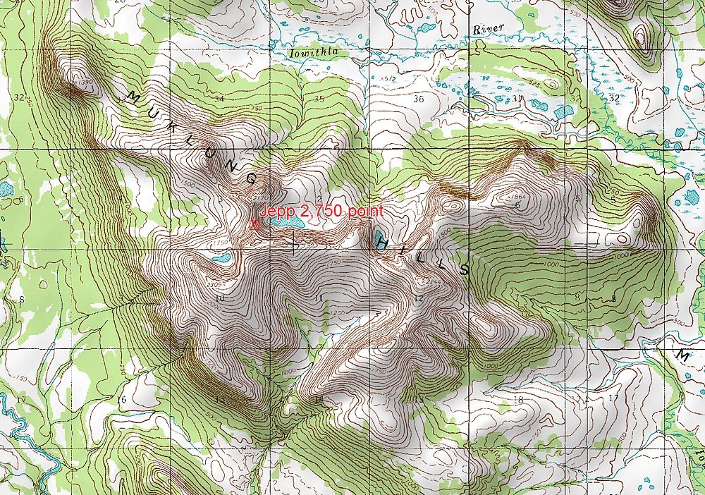
As to the spot obstacle Jeppesen shows on the RNAV 19 chart, they do that in-house using their own topographical data. The source I have is the U.S. 1:50,000 topo map for that area. I'll post the significant portion of that topo chart.
ZEDAG is the course reversal hold for this IAP (RNAV RWY) 19 and it is also the missed approach holding pattern for the RNAV Rwy 01 IAP.
There is no way that ATC can get anyone onto this procedure at less than 5,000 because of the Anchorage Center's MIA. A pilot entering the procedure must be at not less than 5,400 if entering the south TAA or not less than 6,300 if entering the north TAA.
As to the spot obstacle Jeppesen shows on the RNAV 19 chart, they do that in-house using their own topographical data. The source I have is the U.S. 1:50,000 topo map for that area. I'll post the significant portion of that topo chart.
Guest
Thread Starter
Join Date: Apr 2009
Location: On the Beach
Posts: 3,336
Likes: 0
Received 0 Likes
on
0 Posts
This is the Jepp "2750" terrain point. As you can see it is not 2,750...not quite. The FAA chart shows 2,550 at approximately the same location. These cartographic features are not from procedure source; rather they are added by the various chart makers for reference only.
Nonetheless, this is the general area where the BE1900 crash. 2,000 won't get you through that area, and their true altitude was surely lower than 2,000 because of cold station altimeter error.
Nonetheless, this is the general area where the BE1900 crash. 2,000 won't get you through that area, and their true altitude was surely lower than 2,000 because of cold station altimeter error.
Join Date: Dec 2010
Location: S 51 N
Age: 84
Posts: 196
Likes: 0
Received 0 Likes
on
0 Posts
MSA - TAA - MSA - MEA - MOCA
I got to the impression that because of differences for the used similar sounding abbreviations - e.g. MSA - on the two sides of the pond, a bit of a confusions has started and there is talking about two different items. Here in good old Europe it�s all ICAO !!
To solve that, read this:
SKYbrary - Minimum Sector Altitude
aterpster, the difference in shown heights of the mountains could also come from a different charting base. Normally it all should be WGS 84, but could it be possible that some people still use other geo ref systems or simply stick to old procedures ?
Last edited by Annex14; 22nd Mar 2013 at 13:47.
Guest
Thread Starter
Join Date: Apr 2009
Location: On the Beach
Posts: 3,336
Likes: 0
Received 0 Likes
on
0 Posts
Annex14:
You make a good point. Most U.S. Geological Survey charts are referenced to NAD 27. So, if anyone is using a paper topo they would not be using WGS 84. The GIS program I use has corrected the bitmap USGS topos to WGS 84. No doubt that the FAA procedures design department uses obstacle data predicated on WGS 84.
But, the chart makers, for terrain point reference data? Beats me.
Having said that when Jepp adds color terrain contours they appear to be WGS 84 compliant.
And, of course, the FAA sectional visual charts are WGS 84 compliant, as are similar charts in developed nations.
aterpster, the difference in shown heights of the mountains could also come from a different charting base. Normally it all should be WGS 84, but could it be possible that some people still use other geo ref systems or simply stick to old procedures ?
But, the chart makers, for terrain point reference data? Beats me.
Having said that when Jepp adds color terrain contours they appear to be WGS 84 compliant.
And, of course, the FAA sectional visual charts are WGS 84 compliant, as are similar charts in developed nations.
Per Ardua ad Astraeus
Join Date: Mar 2000
Location: UK
Posts: 18,579
Likes: 0
Received 0 Likes
on
0 Posts
Interesting, when important elevations are not agreed. All other things being equal, if Mr X impacts 50' below the top of a 2750' spot height charted at 2550', is the chart provider liable?
Guest
Thread Starter
Join Date: Apr 2009
Location: On the Beach
Posts: 3,336
Likes: 0
Received 0 Likes
on
0 Posts
BOAC:
They would probably be sued, but with a couple of good expert witnesses for the defense, the defense would (or should) prevail. The segment and TAA altitudes are all correct and "shout" on paper to not descend below 4300 in that area. And, it is higher than 4300 if not in the holding pattern, but in that sector or area.
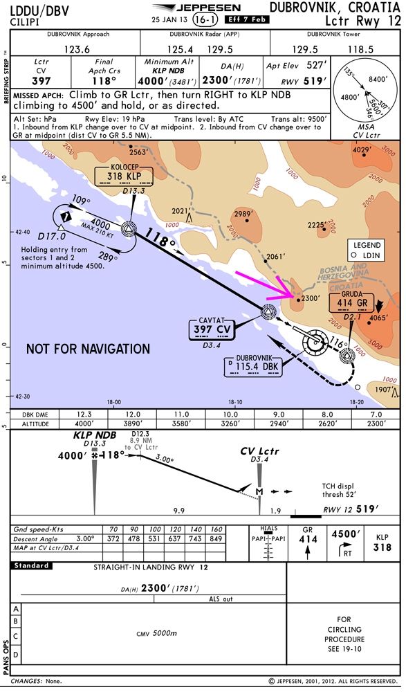
Jeppesen lost at Durovnik because of a shadow box issue with one of the NDBs. But, that had an operational nuance.
Interesting, when important elevations are not agreed. All other things being equal, if Mr X impacts 50' below the top of a 2750' spot height charted at 2550', is the chart provider liable?
Jeppesen lost at Durovnik because of a shadow box issue with one of the NDBs. But, that had an operational nuance.
Join Date: Jan 2008
Location: Torquay UK
Age: 95
Posts: 163
Likes: 0
Received 0 Likes
on
0 Posts
dubrovnik
Please pm, explain "shadow box " , and which / when,.. was that a Britannia in early 60s?
I landed there the next day and visited the site. I seem to remember an unusual approach , (ILS working, but notammed as out of service) , taking 4 approach markers instead of 3, which could have lead to incorrectly crossing them each at the height specified for the next.
They CFIT about the inner marker , querying on the RT about 'ground fog' when they lost sight of the runway , it was a gin clear night and they were below the trees
Guest
Thread Starter
Join Date: Apr 2009
Location: On the Beach
Posts: 3,336
Likes: 0
Received 0 Likes
on
0 Posts
wily:
1996 CFIT of US Air Force 737 carrying Clinton's Secretary of Commerce Brown. Because of the war the ILS was missing in action. So, the approach was a dual NDB approach. Jeppeson designates the primary nav aid with a shadow box. That was messed up in this case, or at least so alleged in the lawsuit that followed.
It's been a long time. I am sure you can Google it.
Please pm, explain "shadow box " , and which / when,.. was that a Britannia in early 60s?
I landed there the next day and visited the site. I seem to remember an unusual approach , (ILS working, but notammed as out of service) , taking 4 approach markers instead of 3, which could have lead to incorrectly crossing them each at the height specified for the next.
They CFIT about the inner marker , querying on the RT about 'ground fog' when they lost sight of the runway , it was a gin clear night and they were below the trees
I landed there the next day and visited the site. I seem to remember an unusual approach , (ILS working, but notammed as out of service) , taking 4 approach markers instead of 3, which could have lead to incorrectly crossing them each at the height specified for the next.
They CFIT about the inner marker , querying on the RT about 'ground fog' when they lost sight of the runway , it was a gin clear night and they were below the trees
It's been a long time. I am sure you can Google it.
Actually, I think they stuck terrain beyond the airport. The 737 flown only had 1 ADF onboard when dual ADF was required.
Back to AK.....
Back to AK.....
All other things being equal, if Mr X impacts 50' below the top of a 2750' spot height charted at 2550', is the chart provider liable?
As in this case, where the high point was 2,250, and the minimum safe altitude was 2,050 feet higher (4,300').
Per Ardua ad Astraeus
Join Date: Mar 2000
Location: UK
Posts: 18,579
Likes: 0
Received 0 Likes
on
0 Posts
As in this case, where the high point was 2,250, and the minimum safe altitude was 2,050 feet higher (4,300').
Try 2550' (or 2750') to taste, and 6300'? (or 4100', or....). Nice and easy, isn't it?
It would appear that the TAA figures bear no resemblance to 'min safe' altitudes, since according to the FAA LOC/DME R19 it is 'safe' at 4100' over that peak.
Guest
Thread Starter
Join Date: Apr 2009
Location: On the Beach
Posts: 3,336
Likes: 0
Received 0 Likes
on
0 Posts
BOAC:
TAA "apples" and holding pattern "oranges." The outer TAA area of 6,300 covers vastly larger topography than does the holding pattern. In any case, the TAA inner area is 4,300, the same altitude as the holding pattern, because the same terrain controls for both the inner area and the holding pattern.
Although the 6,300 area goes out 30 miles for the pilot, the obstacle assessment area extends out an additional 4 miles. That is a lot of real estate.
- I think you are looking at different charts to the rest of us. Try ours - FAA or Jepp, which ever you believe.
Try 2550' (or 2750') to taste, and 6300'? (or 4100', or....). Nice and easy, isn't it?
It would appear that the TAA figures bear no resemblance to 'min safe' altitudes, since according to the FAA LOC/DME R19 it is 'safe' at 4100' over that peak.
Try 2550' (or 2750') to taste, and 6300'? (or 4100', or....). Nice and easy, isn't it?
It would appear that the TAA figures bear no resemblance to 'min safe' altitudes, since according to the FAA LOC/DME R19 it is 'safe' at 4100' over that peak.
Although the 6,300 area goes out 30 miles for the pilot, the obstacle assessment area extends out an additional 4 miles. That is a lot of real estate.
OK, my bad - the FAA cushion is more like 1,500 feet.
That doesn't change the important part of my point - if the pilot stays at the charted safe altitude of 4300 feet (or even 4100 feet), the disparity between 2550 feet or 2725 feet as the highest terrain point is really irrelevant.
if you're so low that a geographical elevation error of 50, or even 250 feet, makes the difference between safe passage and a crash - you're far too low in any event. At least in IMC - we'll acknowledge that there are visual approaches that cut things that fine.
Per Ardua ad Astraeus
Join Date: Mar 2000
Location: UK
Posts: 18,579
Likes: 0
Received 0 Likes
on
0 Posts
if you're so low that a geographical elevation error of 50, or even 250 feet, makes the difference between safe passage and a crash - you're far too low in any event. At least in IMC - we'll acknowledge that there are visual approaches that cut things that fine.
Edit to add: Incidentally
OK, my bad - the FAA cushion is more like 1,500 feet.
Last edited by BOAC; 23rd Mar 2013 at 18:00.