


Kauai tour helicopter missing 27th Dec 2019

Thread Starter

Joined: Mar 2005
Posts: 651
Likes: 127
From: West
Kauai tour helicopter missing 27th Dec 2019
https://www.hawaiinewsnow.com/2019/1...eople-onboard/
By HNN Staff | December 26, 2019 at 9:51 PM HST - Updated December 27 at 2:53 PM HONOLULU, Hawaii (HawaiiNewsNow) - The wreckage of a helicopter that went missing Thursday while on a tour of Kauai’s Na Pali Coast has been found in a remote area of the island, officials confirmed.
There were seven people, including two children, onboard the chopper when it went down.
Authorities fear there were no survivors in the crash, multiple sources told to Hawaii News Now.
Kauai Mayor Derek Kawakami said the county is working to contact the families of those involved and assess the crash area.
“We want to offer our thoughts and prayers to everyone involved,” Kawakami said.
First responders found the chopper wreckage about 9:30 am. Friday in a remote area of Kokee, about 13 miles north of Hanapepe.
When asked whether there were any survivors, Kauai Fire Department Battalion Chief Sol Kanoho said at a news conference Friday that he has “no actionable information on the status of the passengers.”
He said in addition to the pilot, there were two groups of passengers onboard the chopper ― a party of two and a party of four.NTSB is investigating
The FAA said the helicopter that went down was a Eurocopter AS350 B2. The agency said it will work with the NTSB as it investigates the cause of the crash.
Kanoho said the helicopter went down on a “prescribed route” for air tours, indicating that the pilot didn’t deviate on the way back to Lihue.
The aircraft was due to return from the Na Pali Coast tour at 5:21 p.m. Thursday.
When the helicopter didn’t get back by 6 p.m., the Coast Guard was alerted and a search was launched.
According to a preliminary report, authorities last made contact with the helicopter around 4:40 p.m., when the pilot reported that the tour was leaving the Waimea Canyon area.‘Our thoughts are with the families’
The aircraft belongs to Safari Helicopters, a tour helicopter company based in Lihue. Company officials declined to comment Friday.
In a statement Friday afternoon, Gov. David Ige said the state has offered its support as “rescue and recovery efforts continue.”
He added, “Our thoughts are with the families of those onboard as search and rescue crews work at the site of the helicopter crash on Kauai.”
The aircraft was equipped with an electronic locator, but it didn’t go off. After the chopper went missing, the Coast Guard launched a search by air and sea.
The Navy, Civil Air Patrol, Department of Land and Natural Resources, the Kauai National Guard, and commercial helicopters subsequently joined the search.
Petty Officer 1st Class Robert Cox, of Coast Guard Joint Rescue Command Center Honolulu, said weather conditions in the search area were “challenging" with low visibility and blustery winds.Third helicopter crash in 2019
The incident is the third helicopter crash in Hawaii so far this year.
In April, a helicopter went down on a busy Kailua street, killing all three people onboard.
That same month, a state-contracted helicopter crashed in Sacred Falls Valley on Oahu’s North Shore. Four people in the craft escaped injury.
Other recent incidents include:
Copyright 2019 Hawaii News Now. All rights reserved.
There were seven people, including two children, onboard the chopper when it went down.
Authorities fear there were no survivors in the crash, multiple sources told to Hawaii News Now.
Kauai Mayor Derek Kawakami said the county is working to contact the families of those involved and assess the crash area.
“We want to offer our thoughts and prayers to everyone involved,” Kawakami said.
First responders found the chopper wreckage about 9:30 am. Friday in a remote area of Kokee, about 13 miles north of Hanapepe.
When asked whether there were any survivors, Kauai Fire Department Battalion Chief Sol Kanoho said at a news conference Friday that he has “no actionable information on the status of the passengers.”
He said in addition to the pilot, there were two groups of passengers onboard the chopper ― a party of two and a party of four.NTSB is investigating
The FAA said the helicopter that went down was a Eurocopter AS350 B2. The agency said it will work with the NTSB as it investigates the cause of the crash.
Kanoho said the helicopter went down on a “prescribed route” for air tours, indicating that the pilot didn’t deviate on the way back to Lihue.
The aircraft was due to return from the Na Pali Coast tour at 5:21 p.m. Thursday.
When the helicopter didn’t get back by 6 p.m., the Coast Guard was alerted and a search was launched.
According to a preliminary report, authorities last made contact with the helicopter around 4:40 p.m., when the pilot reported that the tour was leaving the Waimea Canyon area.‘Our thoughts are with the families’
The aircraft belongs to Safari Helicopters, a tour helicopter company based in Lihue. Company officials declined to comment Friday.
In a statement Friday afternoon, Gov. David Ige said the state has offered its support as “rescue and recovery efforts continue.”
He added, “Our thoughts are with the families of those onboard as search and rescue crews work at the site of the helicopter crash on Kauai.”
The aircraft was equipped with an electronic locator, but it didn’t go off. After the chopper went missing, the Coast Guard launched a search by air and sea.
The Navy, Civil Air Patrol, Department of Land and Natural Resources, the Kauai National Guard, and commercial helicopters subsequently joined the search.
Petty Officer 1st Class Robert Cox, of Coast Guard Joint Rescue Command Center Honolulu, said weather conditions in the search area were “challenging" with low visibility and blustery winds.Third helicopter crash in 2019
The incident is the third helicopter crash in Hawaii so far this year.
In April, a helicopter went down on a busy Kailua street, killing all three people onboard.
That same month, a state-contracted helicopter crashed in Sacred Falls Valley on Oahu’s North Shore. Four people in the craft escaped injury.
Other recent incidents include:
- A chopper that crash landed on a Kaneohe Bay sandbar in October 2018, injuring the pilot and two passengers.
- The January 2016 crash of a tour helicopter on Kauai’s Na Pali Coast. In that incident, five passengers suffered injuries.
- A February 2016 crash of a helicopter into Pearl Harbor that killed a teenage passenger visiting with his family from Canada.
Copyright 2019 Hawaii News Now. All rights reserved.
Last edited by Senior Pilot; 28th December 2019 at 00:36. Reason: Add quote: this helps Rotorheads know what you're posting about!


Joined: Sep 2003
Posts: 2,081
Likes: 189
From: Redding CA, or on a fire somewhere
I suspect they know within a few miles where the aircraft is located, based upon the reports centering on the Napali coast. Most have satellite trackers on board these days, I am not sure as to whether Safari does or not.
I flew tours on Kauai for 7 years. I remember one going missing about the same time of day before I left, at first light, every helicopter on the Island got airborne to search, we loaded up the helicopters with "observers", (mostly our office staff---it did not matter which company, people just got on the next helicopter with open seats), it was not till 14:00 that we located the wreckage of that one. Kauai is an inhospitable place.
The fact that there is no beacon going off does not bode well.
Joined: Jul 2005
Posts: 48
Likes: 0
From: USA
Gordy, did you have a regular flight path over the Napali? I would think if it was down over land the ELT would have pinged. Not sure what time of day this occured, but there are also boat tours for whale watching over that way. Surprised (a bit) that no vessels in the vicinity.
Joined: Sep 2003
Posts: 2,081
Likes: 189
From: Redding CA, or on a fire somewhere
Gordy, did you have a regular flight path over the Napali? I would think if it was down over land the ELT would have pinged. Not sure what time of day this occured, but there are also boat tours for whale watching over that way. Surprised (a bit) that no vessels in the vicinity.
Most boat tours have left that portion of the shoreline by that time....(around 5pm).
Joined: Sep 2003
Posts: 2,081
Likes: 189
From: Redding CA, or on a fire somewhere
Wreckage Found
Looks like they found it in Nualolo valley which is about 500 feet to the West of Honopu valley.
No survivors.
Looks like they found it in Nualolo valley which is about 500 feet to the West of Honopu valley.
No survivors.
Joined: Jul 2005
Posts: 48
Likes: 0
From: USA
"Petty Officer 1st Class Robert Cox, of Coast Guard Joint Rescue Command Center Honolulu, said Thursday night that weather conditions in the search area were “challenging" with low visibility and blustery winds."
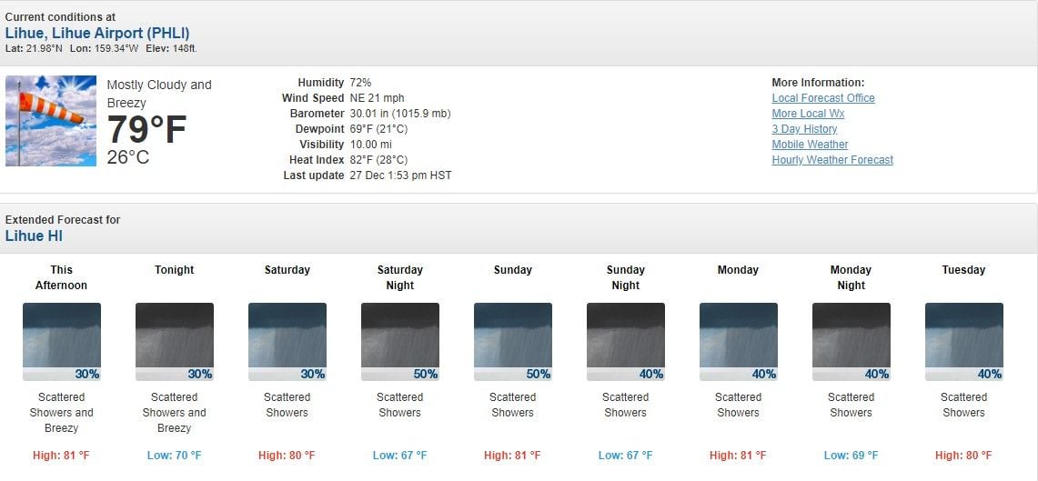
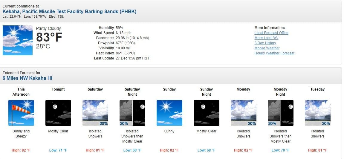
I decided to check for myself and while airport conditions might be far from what's going on at the Napali Coast, this does give an indication. Perhaps some other pilots in the area at the time will report the conditions.
https://aviationweather.gov/metar/da...=off&layout=on
Not the best conditions for a tour over the Napali....Perhaps you've been in difficult meteorological conditions up that way and can voice your experience. When I try and visualize a low ceiling with high winds, the last place I would want to be is near Nualolo Valley. Sad....When I learn of these tragedies, I always think of the "what if" scenarios that would have produced a different outcome. Still trying to understand why no ELT ping.
Aloha
Joined: Sep 2003
Posts: 2,081
Likes: 189
From: Redding CA, or on a fire somewhere
The walls of Nualolo valley are near vertical and the unless a satellite is directly overhead, I doubt it would pick up a transmitting beacon. I am guessing they kind of knew roughly where to look as there is also some radar coverage in that area, although it takes time to get it from Honolulu.
Joined: Jul 2005
Posts: 48
Likes: 0
From: USA
True re micro climates in Hawaii....The mountains basically collect all the rain on the rainy side.... That said, did you ever experience low ceiling or heavy cloud cover obscuring the tops of the range with winds? Perhaps you know, or we will learn if any other heli tours were active in that area at that time....I don't know if conditions were a factor in a go/no go decision....
Re ELT, I'm not sure what equip. they had aboard, but I'd be surprised if it didn't still have 121.5...In that terrain, I would think you would want some redundancy and not just 406...
I agree and unfortunately I don't think it was reported missing until after 6 right around sunset. So even other operators couldn't really have launched and provided much visual help. Had to wait until daybreak.
Joined: Sep 2003
Posts: 2,081
Likes: 189
From: Redding CA, or on a fire somewhere

Joined: Nov 2013
Posts: 20
Likes: 0
From: .
The walls of Nualolo valley are near vertical and the unless a satellite is directly overhead, I doubt it would pick up a transmitting beacon. I am guessing they kind of knew roughly where to look as there is also some radar coverage in that area, although it takes time to get it from Honolulu.
Joined: Sep 2003
Posts: 2,081
Likes: 189
From: Redding CA, or on a fire somewhere
Where did you read that? The radio position report is made at the Upper or Lower lookout depending upon weather conditions. (90% of the time you exit the canyon at the upper). From there it is mostly flat gentle sloping ground all the way to the coast. If it crashed here, chances are the ELT would work. I heard Nualolo valley, the top of which is Kokee State Park, (the other possible location). I have not heard an accurate position yet, but ifen it was in fact in the valley, there is nowhere flat and the aircraft would have dropped to the valley floor, where there is slim chance of a signal getting out. At the widest the valley is maybe 1,500' wide.
Joined: Nov 2013
Posts: 20
Likes: 0
From: .
Where did you read that? The radio position report is made at the Upper or Lower lookout depending upon weather conditions. (90% of the time you exit the canyon at the upper). From there it is mostly flat gentle sloping ground all the way to the coast. If it crashed here, chances are the ELT would work. I heard Nualolo valley, the top of which is Kokee State Park, (the other possible location). I have not heard an accurate position yet, but ifen it was in fact in the valley, there is nowhere flat and the aircraft would have dropped to the valley floor, where there is slim chance of a signal getting out. At the widest the valley is maybe 1,500' wide.
Joined: Aug 2009
Posts: 36
Likes: 0
From: Around
ELT's, CPI's, ADELT's, PLB's, EPIRB's etc are all meant to provide a means of locating someone in distress, particularly in remote areas / areas lacking in radio coverage. We know that despite all the possibilities to carry such devices, they often fail to work on the day, for whatever reason.
Satellite tracking, with adequate monitoring of flightpath, seems a far more reliable method of directing SAR to the necessary location. Simply because where the signal /track stops the aircraft will be located within a 3 minute radius. It can also have an emergency mode if the crew are aware of an emergency.
I think we place too much regulatory reliance on devices we know do not ensure success in rapidly locating when required.
Joined: Sep 2003
Posts: 2,081
Likes: 189
From: Redding CA, or on a fire somewhere
Those cliffs are near vertical, so back of valley or top on Kokee are almost same thing. A typical tour route, (I have flown this route thousands of times), would have you cross the front of the valley then right turn towards the back wall and do a left descending turn in the valley and come out the front. So pure guess work, he may have hit the back wall, but pure speculation at this point.
Joined: Nov 2013
Posts: 20
Likes: 0
From: .
Those cliffs are near vertical, so back of valley or top on Kokee are almost same thing. A typical tour route, (I have flown this route thousands of times), would have you cross the front of the valley then right turn towards the back wall and do a left descending turn in the valley and come out the front. So pure guess work, he may have hit the back wall, but pure speculation at this point.