


SAR S-92 Missing Ireland


Joined: Oct 2004
Posts: 469
Likes: 4
From: HLS map - http://goo.gl/maps/3ymt
A ‘Honeywell Primus 701A’ weather radar system was fitted. This system is a high resolution, fully stabilised, high power, digital radar, designed for high resolution weather detection and terrain mapping. The radar manufacturers’ manual includes the following warning:
‘THE SYSTEMS PERFORM ONLY THE FUNCTIONS OF WEATHER DETECTION OR MAPPING. IT SHOULD NOT BE USED OR RELIED UPON FOR PROXIMITY WARNING OR ANTI-COLLISION PROTECTION’.
‘THE SYSTEMS PERFORM ONLY THE FUNCTIONS OF WEATHER DETECTION OR MAPPING. IT SHOULD NOT BE USED OR RELIED UPON FOR PROXIMITY WARNING OR ANTI-COLLISION PROTECTION’.


Joined: Apr 2000
Aviation Qualifications: ATP+Mil
Posts: 10,959
Likes: 1,814
From: EGDC
The fact is that the maps being used for navigation/situation awareness did not have the lighthouse/island on it.
Joined: Mar 2009
Posts: 82
Likes: 0
From: EU
Just for the record:
The Department of Transport fully accepts the recommendations contained within the report and will continue to evaluate the findings of the report in the coming weeks.
Since receiving the draft Final Report in September 2019, the Department of Transport has undertaken a significant programme of change across key areas to take account of issues raised and recommendations addressed to the Minister of Transport.
Commenting on the publication of the AAIU R116 report Minister Ryan said:
“This was a tragic accident that claimed the lives of four individuals who were dedicated to saving the lives of others. I would like to again convey my condolences to the families and loved ones of the R116’s crew at this time. The completion of the investigation and the publication of the report is a key step in ensuring that such accidents are prevented in the future. I wish to acknowledge the investigative work that has been done by the AAIU that has culminated in this report. This is clearly reflected in the level of detail and wide-ranging nature of the report, with safety recommendations that cover all aspects of SAR aviation, both nationally and internationally.”
Minister of State Hildegarde Naughton added: “I would like to take this opportunity to again express my sincere condolences to the families and loved ones of the four members of R116’s crew, and to all who were affected by the accident. I understand that today’s publication of the AAIU’s Final Report will be a difficult time for all involved. I note the final report contains several safety recommendations addressed to the Department of Transport and I look forward to seeing all necessary work, much of which is already commenced, completed as soon as practicable. My door, and the doors of the Department, remain open to the families of the R116 Crew for any assistance that may be required going forward.”
Ministers propose to seek time in Dáil Eireann to allow for Statements on the matter.
https://www.gov.ie/ga/preasraitis/85...-air-accident/
Have CHC issued a statement?
Statement on the publication of AAIU’s Final Report into R116 air accident
Minister Eamon Ryan T.D. and Minister of State Hildegarde Naughton T.D. acknowledge and appreciate the completion of the investigation into the R116 air accident. The accident claimed the lives of R116 crew members Dara Fitzpatrick, Mark Duffy, Ciarán Smith and Paul Ormsby in March 2017 and today marks the publication of the final report into this investigation by the Air Accident Investigation Unit.The Department of Transport fully accepts the recommendations contained within the report and will continue to evaluate the findings of the report in the coming weeks.
Since receiving the draft Final Report in September 2019, the Department of Transport has undertaken a significant programme of change across key areas to take account of issues raised and recommendations addressed to the Minister of Transport.
Commenting on the publication of the AAIU R116 report Minister Ryan said:
“This was a tragic accident that claimed the lives of four individuals who were dedicated to saving the lives of others. I would like to again convey my condolences to the families and loved ones of the R116’s crew at this time. The completion of the investigation and the publication of the report is a key step in ensuring that such accidents are prevented in the future. I wish to acknowledge the investigative work that has been done by the AAIU that has culminated in this report. This is clearly reflected in the level of detail and wide-ranging nature of the report, with safety recommendations that cover all aspects of SAR aviation, both nationally and internationally.”
Minister of State Hildegarde Naughton added: “I would like to take this opportunity to again express my sincere condolences to the families and loved ones of the four members of R116’s crew, and to all who were affected by the accident. I understand that today’s publication of the AAIU’s Final Report will be a difficult time for all involved. I note the final report contains several safety recommendations addressed to the Department of Transport and I look forward to seeing all necessary work, much of which is already commenced, completed as soon as practicable. My door, and the doors of the Department, remain open to the families of the R116 Crew for any assistance that may be required going forward.”
Ministers propose to seek time in Dáil Eireann to allow for Statements on the matter.
Have CHC issued a statement?

Joined: Nov 2009
Posts: 1,556
Likes: 56
From: Inverness-shire, Ross-shire
I have had a look at the mapping aspects of this matter.
OSI land mapping, of the kind one would expect for land SAR, does NOT include Black Rock. The nearest sheet stops at the western tip of the nearest mainland. I downloaded the digital version of the OSI mapping and although a detached piece of OSI's grid appears in the ocean where one would expect Black Rock to be, no land is shown at that location. I have established that this is not a historical omission caused by the previous rulers of Ireland since the OSGB maps held by the National Library of Scotland, and probably from surveys before 1913 but revised in the 1940s, DO include Black Rock, although not in great detail and probably without a spot height, although the NLS copy is not very legible in this respect.
None of the secondary mapping providers, such as Open Street map, show useful detail for Black Rock even though some show the buildings and helipad.
Worryingly, I also found an online map by SWC maps, that displayed a respresentation of Black Rock blessed with only a 10m contour line for height information. So there is information out there in the wild representing Black Rock as being between 10m and 20m in maximum height above the sea.
Contrast this with the situation in a neighbouring territory. Alisa Craig is an island that, just like Black Rock, is less than 10NM off the coast. Even secondary mapping like Open Street Map shows the spot height for the highest point on the island. The normal OSGB mapping that one would expect to use for land SAR shows information from a full survey with 10m contours and spot heights.
Similarly, considering an uninhabited and unexploited island, more than 30NM west of inhabited land, thus one that might be considered far less significant than Black Rock, Stac an Armin (extreme fragment of St Kilda), appears on OSGB mapping (including Landranger sheet 18 and digital versions) with 10m contours and a spot height and on Open Street Map with a spot height.
I note that the OSI website is illustrated with more than one image of surveyors working on rugged coastlines with boats. One might hope that these recent photographs have been made possible by a realisation that there are consequences to dismissing even one square metres of Irish land when one's reputation and sales are based on a centimetre-accurate mapping service.
Joined: Sep 2009
Posts: 214
Likes: 14
From: UK
Maritime Mapping.
It’s relevance has been discussed above with some dismissing its importance for SAR operations. These are commonly used in UKSAR and have done since the beginning of the current contract. When conducting maritime and littoral let downs either IMC or on NVG, the front end are using aeronautical charts and the back end are following up with a combination of aeronautical and maritime digital mapping. Contacts on radar/FLIR are cross checked with the charts in order to identify buoys and low laying terrain.
LZ
Joined: Mar 2005
Aviation Qualifications: Military
Posts: 6,563
Likes: 952
From: Aus
because they had no NVG and the procedural let down was all they had. Could that have been executed better? Possibly
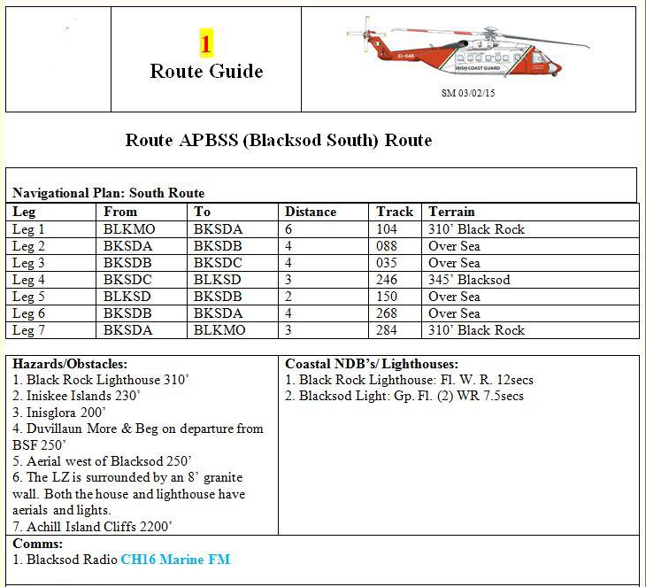
At 00.10 hrs, the Commander briefed the Co-pilot on the approach into Blacksod:
‘I think we just go straight over and when we're happy enough to step it down em down below two four we'll do the approach one all the way down, let it just fly the route, get the speed back until we’re comfortable and literally just let it fly all the way round em if we're happy with the visuals on the first run-in it'll be on my side so it’ll be my landing. We’ll go in, if not we'll just do a circuit all the way around and eh we'll make sure it’s on a two four zero heading’
‘I think we just go straight over and when we're happy enough to step it down em down below two four we'll do the approach one all the way down, let it just fly the route, get the speed back until we’re comfortable and literally just let it fly all the way round em if we're happy with the visuals on the first run-in it'll be on my side so it’ll be my landing. We’ll go in, if not we'll just do a circuit all the way around and eh we'll make sure it’s on a two four zero heading’
The let-down procedure was briefed by the Commander, with all timings and acknowledgements by the Co-pilot presented in square brackets, as follows:
‘[Commander at 00.30:01 hrs] okay let-down procedure, can I wait until we're abeam this alpha position [an apparent reference to waypoint BKSDA] here [Co-pilot acknowledged at 00.30:05 hrs: okay] [Commander at 00.30:06 hrs] and then we're going to, I'm going to select alt pre down to two thousand and four hundred feet, [Co-pilot acknowledged at 00.30:09 hrs: roger] [Commander at 00.30:10 hrs] if you're happy we're clear of everything [Co-pilot acknowledged at 00.30:11 hrs: understood] [Commander at 00.30:12 hrs] I’m going to do an approach one all the way down to two hundred feet, eighty knots, [Co-pilot acknowledged at 00.30:15 hrs: yes] [Commander at 00.30:16 hrs] eh, it might be slightly past M O [an apparent reference to waypoint BLKMO] at that moment so we'll see what, how we are height wise at that moment, so I think we'll just eh take a heading, continue on past there go back around and the aim is just to follow the route all the way round em and eh [Co-pilot acknowledged at 00.30:27 hrs: roger understood] [Commander at 00.30:29 hrs] getting the speed back as much as we're comfortable, we're aware we're going to have a pretty high ground speed on the way in. [Co-pilot acknowledged at 00.30:34 hrs: Okay]’
‘[Commander at 00.30:01 hrs] okay let-down procedure, can I wait until we're abeam this alpha position [an apparent reference to waypoint BKSDA] here [Co-pilot acknowledged at 00.30:05 hrs: okay] [Commander at 00.30:06 hrs] and then we're going to, I'm going to select alt pre down to two thousand and four hundred feet, [Co-pilot acknowledged at 00.30:09 hrs: roger] [Commander at 00.30:10 hrs] if you're happy we're clear of everything [Co-pilot acknowledged at 00.30:11 hrs: understood] [Commander at 00.30:12 hrs] I’m going to do an approach one all the way down to two hundred feet, eighty knots, [Co-pilot acknowledged at 00.30:15 hrs: yes] [Commander at 00.30:16 hrs] eh, it might be slightly past M O [an apparent reference to waypoint BLKMO] at that moment so we'll see what, how we are height wise at that moment, so I think we'll just eh take a heading, continue on past there go back around and the aim is just to follow the route all the way round em and eh [Co-pilot acknowledged at 00.30:27 hrs: roger understood] [Commander at 00.30:29 hrs] getting the speed back as much as we're comfortable, we're aware we're going to have a pretty high ground speed on the way in. [Co-pilot acknowledged at 00.30:34 hrs: Okay]’
Having just finished reading the report there is much to cogitate upon, what I've written above re brief is merely one element in the mix of organisational failures, still would have saved the day though, length of time they had been awake would explain why anyone would be off their game.
Last edited by megan; 8th November 2021 at 04:59. Reason: Self Reflection
Joined: Apr 2000
Aviation Qualifications: ATP+Mil
Posts: 10,959
Likes: 1,814
From: EGDC
length of time they had been awake would explain why anyone would be off their game
The nature of SAR is unpredictable and managing fatigue is essential - I always tried to have a nap in the afternoon if possible which helped enormously when the phone rang late in the evening or overnight, and yes, people did take the p*ss out of me for doing it but it worked for me.
Joined: Apr 2000
Aviation Qualifications: ATP+Mil
Posts: 10,959
Likes: 1,814
From: EGDC
At 00.45 hrs, the Co-pilot announced ‘okay so small targets at six miles at 11 o'clock … large out to the right there’. This was followed approximately 20 seconds later by an Auto Callout ‘Altitude, Altitude’, which the Commander said was ‘just a small little island that's B L M O itself’.
They had nearly 10 miles to run before they were even abeam Blacksod so they didn't need to be at 200'.
I know it is easy to be wise with 20/20 hindsight but that was not a great let down route into the refuel site.
Joined: Apr 2021
Posts: 40
Likes: 4
From: Underground
Are the implications of this statement more wide reaching than SAR? As someone who has never flown offshore ARAs, is the weather radar performing a purely ‘terrain mapping’ function during an ARA, i.e. confirmatory position information for the rig location, rather than proximity warning or anti-collision protection? I had always assumed, perhaps incorrectly, that it was used to ensure the path was clear on final approach track to the decision point (and thereby performing an anti-collision function), and also was also used to provide essential proximity information on which the decision point was based.
That being said the phrases “proximity warning” and “ant collision protection” are quite vague. On approach to a rig using the radar, it is used to determine floating obstacles such as standby vessels or other boats in the desired approach path and the range to those obstacles and the destination. Whiles this provides proximity information, it doesn’t provide a proximity “warning”, neither is that information considered particularly accurate below 0.5nm. Anti-collision protection falls under much the same logic I would think.
In my anecdotal experience, the GMAP terrain modes of the radar weren’t particularly more effective than fiddling with the gain and tilt of the normal Wx mode
Joined: Feb 2001
Posts: 542
Likes: 5
From: Europe
Apart a host of other issues, the Conclusions section of this report highlights that Black Rock was not in the EGPWS database, on the 1:250,000 aeronautical chart, Euronav imagery or Toughbook. As others have commented on. So mapping was not 100% reliable. But is that really surprising? Would anyone sensible assume that every one of Ireland’s no doubt hundreds of small islands is accurately recorded? Accurately enough to be confident bowling along at night in IMC conditions at 200ft for a planned 10 miles? Just nuts, as I know Crab and gulli agree.
There is a far simpler check that could and should have been done if this highly risky approach was going to be followed – just look at Google Earth. In the corporate world I operate in, whenever I’m going somewhere new I (and I’m sure many others) look at the approach and landing site on Google Earth. Together of course with charts. But photos don’t lie. A 15 second look at the APBSS approach on Google Earth would have made Black Rock glaringly obvious. And there’s even a photo to click on that shows it to be a bloody great lump of rock, about 300ft high! Even if the elevation cursor only shows it as 11m – not that you’d ever rely on that. But amongst the 37 Safety Recommendations not one says do a check on Google Earth!
Sometimes I feel that the world of aviation is so bogged down in a lifetime’s reading of documents and procedures that the obvious is missed.
Joined: Mar 2005
Aviation Qualifications: Military
Posts: 6,563
Likes: 952
From: Aus
bowling along at night in IMC conditions at 200ft for a planned 10 miles? Just nuts, as I know Crab and gulli agree
There is a far simpler check that could and should have been done if this highly risky approach was going to be followed – just look at Google Earth
Checking Google Earth - The contract requirement was to be airborne 45 minutes after call out, they were 8 minutes late in meeting that requirement, so I doubt a lack of thoroughness in preparation was a factor. They originally were not going to Black Rock in any event, it was a diversion decision made in flight, I doubt Google would have been able to be accessed from the aircraft.
Joined: May 2002
Posts: 2,697
Likes: 71
From: Wanaka, NZ
...Would anyone sensible assume that every one of Ireland’s no doubt hundreds of small islands is accurately recorded? Accurately enough to be confident bowling along at night in IMC conditions at 200ft for a planned 10 miles? Just nuts, as I know Crab and gulli agree..
Joined: Mar 2005
Aviation Qualifications: Military
Posts: 6,563
Likes: 952
From: Aus
I find it difficult to believe that nobody "stepped back" and thought for a minute there must be a better way to do what they were doing.
Guest

Joined: Jan 2006
Aviation Qualifications: Spotter
Posts: 0
Likes: 239
From: EU
The FMS could have been used to set up any number of interceptions for a downwind leg or base leg; cross-checking on the WX radar that the sector is free. The bay was otherwise almost entirely free of obstacles so why on earth did they fly out to the island anyway, as there were other POS RNAV WYPTS that could have been used to join the route? And why did nobody ask “how high is Black Rock?” And look at the chart to check. Even with the incorrect information on the chart, 200ft was always going to lead to a collision with the plan to fly over at that height..
From the moment the rear crewman called the object and suggested coming right (2nd call), they had about 12 seconds to impact. But the crew remained in a SA fog until the very last seconds.
Last edited by PPRuNeUser129638; 9th November 2021 at 07:34.

Joined: Jan 2012
Posts: 366
Likes: 10
From: Below transition level
I am still disturbed by the 'CRM dance' of the PF asking the PM for a course correction when a trusted crew member in the back has identified terrain ahead. Fair enough they are following their SOPs for operating under AP when flying what they think is a safe approach. However as soon as un-identified terrain is sighted ahead then it might be a big clue that the approach/let down is no longer safe. The winch man in the back seeing a big rock/lighthouse ahead is analogous to a terrain command from the GPWS and surely at that point the AP should be disconnected immediately and avoiding action taken?
Caveat, I am fixed wing pilot but shocked that the crew acted in this way. Multiple calls and 12 seconds from sighting terrain until hitting it. Very sad.
Caveat, I am fixed wing pilot but shocked that the crew acted in this way. Multiple calls and 12 seconds from sighting terrain until hitting it. Very sad.
Last edited by Fostex; 9th November 2021 at 09:53.
Joined: Feb 2001
Posts: 542
Likes: 5
From: Europe
Megan - a far better way to do it would have been simply to do a let down from the NE to a point say 2nm NE of Blacksod. They would have been into wind, so with a G/S of circa 40kts, and around 2nm away from any other land. They would almost certainly have seen Blacksod lighthouse flashing at 300ft and positioned in. It would also been a lot faster and burst less fuel.
And anyhow, how did R118 get into Blacksod? That clearly worked. Does anyone know if that info is buried in the 350 pages of the report? Did R116 crew establish how R118 were planning on approaching? Would have been wise.
Fostex - yes, the slowness of the response to the report of land ahead steer right was dreadful. An immediate action of uncoupling and doing a rapid climbing turn would have unquestionably saved the day. Or even not uncoupling but just doing it, not querying it. How much was tiredness or just inadequate competence from the crew I don't know, but decision making just was not good enough.
I will try and read the report in full.
Joined: May 2001
Posts: 222
Likes: 11
"Fostex - yes, the slowness of the response to the report of land ahead steer right was dreadful. An immediate action of uncoupling and doing a rapid climbing turn would have unquestionably saved the day. Or even not uncoupling but just doing it, not querying it."
I couldn't agree more. Our SOP for a late sighting of an obstruction (with risk of collision) whilst at low level on NVG was a call of "Up, up, up" from any crew member which would initiate an immediate low level abort, without question. It absolutely saved me and my crew's life on one occasion when a crew member in the jump seat saw a significant mast in our flight path which hadn't been seen by either pilot.
I couldn't agree more. Our SOP for a late sighting of an obstruction (with risk of collision) whilst at low level on NVG was a call of "Up, up, up" from any crew member which would initiate an immediate low level abort, without question. It absolutely saved me and my crew's life on one occasion when a crew member in the jump seat saw a significant mast in our flight path which hadn't been seen by either pilot.
Joined: May 2002
Posts: 2,697
Likes: 71
From: Wanaka, NZ
A better way would have been for any one of four people on board to say "this is not a good idea". I'm bewildered why nobody said so. I'm left to wonder if they had a newly minted 200 hour co-pilot on board who didn't have an ounce of operational experience, but had a bit of gumption, would have piped up and said so. I always fall back to what Marty used to say when I was a newly minted 200 hour co-pilot when contemplating a course of action to complete a task...."what would they say at the subsequent inquiry". Well, at this subsequent inquiry there was quite a bit to say.
Joined: Mar 2005
Aviation Qualifications: Military
Posts: 6,563
Likes: 952
From: Aus
A better way would have been for any one of four people on board to say "this is not a good idea". I'm bewildered why nobody said so. I'm left to wonder if they had a newly minted 200 hour co-pilot on board who didn't have an ounce of operational experience, but had a bit of gumption, would have piped up and said so
I'm pretty sure I know of the incident of which you speak, not much Marty hasn't told me, tooling about in fog, some thing done by all, but the organisation was not one to address issues other than giving the individual lowest on the totem pole a good kicking, I can give you a copy of a letter received by one (TE) who was a mere bystander to an incident that management had been told was going to occur if they didn't get their act in order. In typical management cowardice the lowest on the totem pole was given the task of penning the letter, BM. Remember taking a bunch of overseas VIPs offshore and one saying "I thought this was a VFR operation", yer, right, typical management completely out of the loop as to what goes on at the coal face because the budget is sacrosanct when it comes to spending money on infrastructure.