


INS at High Latitude

Thread Starter
Joined: Nov 2005
Posts: 28
Likes: 0
From: Sharp End
I may have missed the point during the theory side of the INS, please could anyone answer this or point me in the right direction. Above a certain latitude we have to switch the heading mode from magnetic to true. When this switching has taken place does the INS now take into account the Variation. Or- can the INS even be used above these latitudes.
Thanks
Thanks


Joined: Dec 2000
Posts: 2,132
Likes: 3
From: on the golf course (Covid permitting)
I think you are confused.
An IRS/INSs' native mode is referenced to True North to start with. When it is switched to Magnetic, it accesses a look-up table of variation by Lat/Long and applies the variation to derive a Magnetic value.
So, when you switch to True, it just uses the native heading value direct.
What has variation got to do with True mode?

Joined: Feb 2005
Aviation Qualifications: ATPL
Posts: 533
Likes: 41
From: Canada / Switzerland
I think that what Ishe might be confused about is a possible requirement to switch from HEADING mode (magnetically corrected heading) to TRACK mode (referenced to true north) when above a certain latitude.
I suspect this is a result of the magnetic variation lookup table not being available (not populated with variation data) above a certain latitude (probably about 80 degrees north), and also not being populated with magnetic variation data in the areas directly above the two magnetic poles.
I suspect this is a result of the magnetic variation lookup table not being available (not populated with variation data) above a certain latitude (probably about 80 degrees north), and also not being populated with magnetic variation data in the areas directly above the two magnetic poles.

Joined: Dec 2002
Aviation Qualifications: ATP+Mil
Posts: 3,984
Likes: 568
From: Where the Quaboag River flows, USA
The issue is the "keyhole", an area 90W to 120W and 70N to 72N in Canada where the variation table cannot update the IRS output from true to magnetic. Some sets show HDG FAIL and require a manual switching to TRUE, others do it automatically. West coast North America to Europe typically can pass thru the keyhole.
Yes, there is one in the southern hemisphere, but few, if any, routes pass thru it. And, yes, an INS/IRS can function properly at high latitudes, in true.
GF
Yes, there is one in the southern hemisphere, but few, if any, routes pass thru it. And, yes, an INS/IRS can function properly at high latitudes, in true.
GF
Joined: Jun 2004
Posts: 1,843
Likes: 0
From: Australia
ishe,
The INS/IRS may be used at any Latitude from 90 degrees North to 90 degrees South to reliably provide TRUE Headings and Tracks. It is completely independant of Magnetic Variation.
Within the areas where Magnetic Variation data is reliable and STABLE, the FMC calculates the local Magnetic Variation from it's internal database, and applies this value to the INS/IRS computed TRUE data to provide Magnetic data. It is commonly held that data is reliable from 60 degrees South to 73 degrees North, at higher Latitudes the Magnetic Variation is either Unusable, Unreliable, or subject to an excessively high annual rate of change.
Although a great deal of the higher latitudes (e.g. up to 80 degrees North)exhibit reliable Magnetic Data, the rate of change can be excessive, thus, the long term use (more than a year or two) of Magnetic Headings / Tracks from the database (currently based upon the year 2005) leads to too much difference between Computed Magnetic data and actual.
As mentioned in an earlier post, even within these reliable areas certain key-holes exist where the use of Magnetic data is not an option.
It would be a better world if we were able to abandon Magnetic data altogether, and go 'fully' TRUE, but this would then require that all aircraft be equipped with INS/IRS, a bit out of the budget of most C172 owners! Magnetic is retained (within the usable latitudes) for commonality between all aircraft.
I have recently been tasked by a FMC manufacturer for provision of an up-graded Magnetic Variation database, which compensates for the actual date and thus computed Magnetic equals actual Magnetic on any given day. Even then such up-graded aircraft would be incompatible with fixed year aircraft databases AND published En-Route Charts, and would only be compatible with those aircraft using Magnetic as a primary source (including AHRS). Even with time compensation the problem arises that the present rate of change, although fairly reliable forecast, also changes. About 5 to 10 years is the limit for such forecasts. The year 2015 is currently about the latest limit for reliable Magnetic predictions, but even then the North Magnetic Pole, after centuries of wandering randomly around Canada, is moving in a straight line at about 70 Km per year towards Russia (the new Northski Magneticski Polski).
A bit long winded, I'm sorry, but that's the gist of it.
Happy Navigating!
Regards,
Old Smokey
Joined: Feb 2005
Aviation Qualifications: ATPL
Posts: 533
Likes: 41
From: Canada / Switzerland
Old Smokey:
Thanks for a very well written post.
Just to avoid confusing folks who are trying to get an understanding of the constraints imposed when trying to apply magnetic variation (from databases) to describe the flight path vector of an aircraft that is derived from using a long range navigation (LRN) system (e.g. INS, or GPS derived track), I think we ought to provide a bit of background information about why long range navigation systems cannot translate "true track made good" (what they work in as a base reference system) to "magnetic heading" or "magnetic track made good".
Others have already pointed out in this discussion that all LRN systems use track (or heading) referenced to true north as their basis of calculation, and that local magnetic variation is then determined by the LRN system from a lookup table and applied to the true track (or heading) to enable the system to present the pilot with a magnetic track (or heading).
In polar regions, there are two constraints that prevent this from being done in certain areas. First is that when you get very far north (or south), beyond 80�, the convergence of the lines of longitude makes it mathematically quite difficult to map magnetic variation with any degree of accuracy or usefulness (plus, of course, the issues of stability, reliability, annual change from epoch year used to construct the database, etc. that you already addressed in your post above). Second is that when you are directly over the magnetic north or south pole, a similar problem arises, with magnetic variation changing so rapidly within a short distance - or not being credible at all - that again it is not possible to create a lookup table of magnetic variation that is accurate or useful.
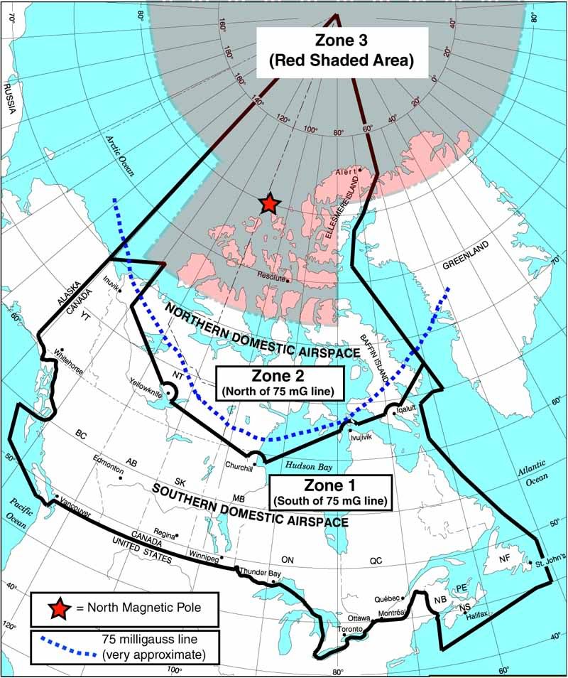
Below is an illustration that I created when writing a Pilot Guide for a long range navigation system that uses GPS derived track (this aircraft is not equipped with INS). South of the 75 milligauss line, the magnetometers in the aircraft can be used to determine magnetic heading. North of the 75 milligauss line, translation of true track to magnetic track can only be accomplished by use of GPS derived track (referenced to true north) which is then converted to magnetic by reference to the lookup tables in the LRN system, provided that the aircraft is in an area for which the LRN has a valid magnetic variation lookup table (in other words, not in a red shaded area).
But, once the aircraft moves into the red-shaded areas, true track can no longer be converted to (and expressed as) magnetic track because no magnetic variation data is available in the LRN database due to the two reasons stated above.
The term "keyhole" refers to the area that is directly above and surrounding the magnetic pole. It's called a keyhole because of the way it looks on the map (below). The circular area above 80� latitude is the area where magnetic variation is not available due to convergence of the lines of longitude, the "keyhole" area around the North Magnetic Pole is the area where magnetic variation is not available because of the darn magnetic pole itself.
I hope this information helps with the discussion - If I have missed anything or stated anything incorrectly, please go ahead and correct me.
Again, in this particular aircraft, no INS reference is available from the LRN, only GPS derived track. If INS reference was available, the pilot would have the additional choice of displaying either heading or track (rather than just GPS derived track) when operating in the very far northern areas.
Michael
Thanks for a very well written post.
Just to avoid confusing folks who are trying to get an understanding of the constraints imposed when trying to apply magnetic variation (from databases) to describe the flight path vector of an aircraft that is derived from using a long range navigation (LRN) system (e.g. INS, or GPS derived track), I think we ought to provide a bit of background information about why long range navigation systems cannot translate "true track made good" (what they work in as a base reference system) to "magnetic heading" or "magnetic track made good".
Others have already pointed out in this discussion that all LRN systems use track (or heading) referenced to true north as their basis of calculation, and that local magnetic variation is then determined by the LRN system from a lookup table and applied to the true track (or heading) to enable the system to present the pilot with a magnetic track (or heading).
In polar regions, there are two constraints that prevent this from being done in certain areas. First is that when you get very far north (or south), beyond 80�, the convergence of the lines of longitude makes it mathematically quite difficult to map magnetic variation with any degree of accuracy or usefulness (plus, of course, the issues of stability, reliability, annual change from epoch year used to construct the database, etc. that you already addressed in your post above). Second is that when you are directly over the magnetic north or south pole, a similar problem arises, with magnetic variation changing so rapidly within a short distance - or not being credible at all - that again it is not possible to create a lookup table of magnetic variation that is accurate or useful.
Below is an illustration that I created when writing a Pilot Guide for a long range navigation system that uses GPS derived track (this aircraft is not equipped with INS). South of the 75 milligauss line, the magnetometers in the aircraft can be used to determine magnetic heading. North of the 75 milligauss line, translation of true track to magnetic track can only be accomplished by use of GPS derived track (referenced to true north) which is then converted to magnetic by reference to the lookup tables in the LRN system, provided that the aircraft is in an area for which the LRN has a valid magnetic variation lookup table (in other words, not in a red shaded area).
But, once the aircraft moves into the red-shaded areas, true track can no longer be converted to (and expressed as) magnetic track because no magnetic variation data is available in the LRN database due to the two reasons stated above.
The term "keyhole" refers to the area that is directly above and surrounding the magnetic pole. It's called a keyhole because of the way it looks on the map (below). The circular area above 80� latitude is the area where magnetic variation is not available due to convergence of the lines of longitude, the "keyhole" area around the North Magnetic Pole is the area where magnetic variation is not available because of the darn magnetic pole itself.
I hope this information helps with the discussion - If I have missed anything or stated anything incorrectly, please go ahead and correct me.
Again, in this particular aircraft, no INS reference is available from the LRN, only GPS derived track. If INS reference was available, the pilot would have the additional choice of displaying either heading or track (rather than just GPS derived track) when operating in the very far northern areas.
Michael
Joined: Mar 2000
Posts: 8,571
Likes: 3
From: Arizona USA
Just to avoid confusing folks ...
IE:
VLF/Omega...in the past, no problems noted by this Commander.
GPS...likewise.
INS...the same.
So, I would ask, what is the beef?
Follow the respective airline's procedures, and it works out...OK.
KISS (keep it simple, stupid) applies.
NB:
With VLF/Omega, large errors can be noticed on desent, however...Omega is not used any more.
Case closed.
Joined: Jun 2004
Posts: 1,843
Likes: 0
From: Australia
And thanks to you V1... Ooops for a very well written post.
It seems that we speak the same language. Nice diagram by the way, I've copied it already and fits very well with my own data, and the limitations incorporated to the revised FMC programme recently finished. A good confidence check!
For those with an interest in the "WHY?" of the normal 73 degrees North limit of most FMC Magnetic Variation databases, take a look at V1... Ooops's excellent diagram where the keyhole cuts off at that latitude. The South Magnetic Pole is at a lower latitude than the North, leading to a 60 degrees latitude "cutoff" (Usually of little interest as very little traffic passes these regions as opposed to Northern regions).
411A, I agree with you regarding the KISS principal, but some folks have to manufacture the data for the end user to be able to keep it simple.
Regards,
Old Smokey
It seems that we speak the same language. Nice diagram by the way, I've copied it already
and fits very well with my own data, and the limitations incorporated to the revised FMC programme recently finished. A good confidence check!For those with an interest in the "WHY?" of the normal 73 degrees North limit of most FMC Magnetic Variation databases, take a look at V1... Ooops's excellent diagram where the keyhole cuts off at that latitude. The South Magnetic Pole is at a lower latitude than the North, leading to a 60 degrees latitude "cutoff" (Usually of little interest as very little traffic passes these regions as opposed to Northern regions).
411A, I agree with you regarding the KISS principal, but some folks have to manufacture the data for the end user to be able to keep it simple.
Regards,
Old Smokey
Joined: Feb 2005
Aviation Qualifications: ATPL
Posts: 533
Likes: 41
From: Canada / Switzerland
Hi Old Smokey:
Feel free to use the illustration (or any derivative of it) in any work you create. I drew the illustration for the Honeywell Pilot Guide for the Primus Apex avionics system installed in the new Series 400 Twin Otter. If you would like the original Adobe Illustrator file, send me a private message and I will get it to you.
The underlying cartography is the work of Nav Canada (it shows the Canadian Southern and Northern domestic airspace), I used it with their permission.
Michael
Joined: Aug 1999
Posts: 1,050
Likes: 4
From: England
I find this a very interesting thread; I love to know whats going on behind the scenes in aircraft systems, but for me Polar operation is outside my experience; all my flying was short / medium haul around Europe.
Anyway, I was reading Mr Boeings Polar Route Navigation By Model page. Wherein the following statement is made for the 747-400:
"When the computed position enters the region north of 84 deg north latitude or the region south of 84 deg south latitude, each FMC shifts down from the triple-mix inertial reference system (IRS) position to a single inertial reference unit (IRU) position. The SPLIT IRS OPERATION message is displayed on the control display unit (CDU) scratchpad message area. This reversion to the single IRS position is necessary because longitude and latitude singularity converge at the poles."
I understand roughly what this is saying, but I don't get the why. Since there is clearly some polar nav expertise present in this thread, I was wondering is anyone could expand on the rationale behind it please?
Thanks,
pb
Per Ardua ad Astraeus
Joined: Mar 2000
Posts: 18,575
Likes: 4
From: UK
I guess there would be too much arguing about position if you allowed 3 to input? An error of 1 minute of longitude drops from 1nm at the equator to 0.1 at 84 north and of course to nothing at the pole.

Joined: Oct 2010
Posts: 2
Likes: 0
From: Xi'an
Can INS provide TRUE Headings at 90 degrees North ?
�The INS/IRS may be used at any Latitude from 90 degrees North to 90 degrees South to reliably provide TRUE Headings and Tracks. It is completely independant of Magnetic Variation.�There is no "true NORTH" at 90 degrees North,how provide true heading?

