Old Smokey:
Thanks for a very well written post.
Just to avoid confusing folks who are trying to get an understanding of the constraints imposed when trying to apply magnetic variation (from databases) to describe the flight path vector of an aircraft that is derived from using a long range navigation (LRN) system (e.g. INS, or GPS derived track), I think we ought to provide a bit of background information about why long range navigation systems cannot translate "true track made good" (what they work in as a base reference system) to "magnetic heading" or "magnetic track made good".
Others have already pointed out in this discussion that all LRN systems use track (or heading) referenced to true north as their basis of calculation, and that local magnetic variation is then determined by the LRN system from a lookup table and applied to the true track (or heading) to enable the system to present the pilot with a magnetic track (or heading).
In polar regions, there are two constraints that prevent this from being done in certain areas. First is that when you get very far north (or south), beyond 80�, the convergence of the lines of longitude makes it mathematically quite difficult to map magnetic variation with any degree of accuracy or usefulness (plus, of course, the issues of stability, reliability, annual change from epoch year used to construct the database, etc. that you already addressed in your post above). Second is that when you are directly over the magnetic north or south pole, a similar problem arises, with magnetic variation changing so rapidly within a short distance - or not being credible at all - that again it is not possible to create a lookup table of magnetic variation that is accurate or useful.
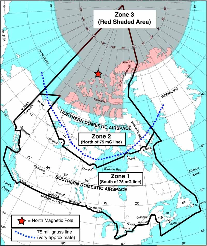
Below is an illustration that I created when writing a Pilot Guide for a long range navigation system that uses GPS derived track (this aircraft is not equipped with INS). South of the 75 milligauss line, the magnetometers in the aircraft can be used to determine magnetic heading. North of the 75 milligauss line, translation of true track to magnetic track can only be accomplished by use of GPS derived track (referenced to true north) which is then converted to magnetic by reference to the lookup tables in the LRN system, provided that the aircraft is in an area for which the LRN has a valid magnetic variation lookup table (in other words, not in a red shaded area).
But, once the aircraft moves into the red-shaded areas, true track can no longer be converted to (and expressed as) magnetic track because no magnetic variation data is available in the LRN database due to the two reasons stated above.
The term "keyhole" refers to the area that is directly above and surrounding the magnetic pole. It's called a keyhole because of the way it looks on the map (below). The circular area above 80� latitude is the area where magnetic variation is not available due to convergence of the lines of longitude, the "keyhole" area around the North Magnetic Pole is the area where magnetic variation is not available because of the darn magnetic pole itself.
I hope this information helps with the discussion - If I have missed anything or stated anything incorrectly, please go ahead and correct me.
Again, in this particular aircraft, no INS reference is available from the LRN, only GPS derived track. If INS reference was available, the pilot would have the additional choice of displaying either heading or track (rather than just GPS derived track) when operating in the very far northern areas.
Michael