


Atmospheric sounding drone

Thread Starter
Atmospheric sounding drone
Hi I'm after a small drone that will relay wind speed and direction plus altitude and OAT to the operator for use of pilots before take off specifically paraglider and balloons. My brother rigged one up with the on-board camera feed transmitting optical reading from an anemometer taped to a small gyrocoptor which was received on a mobile phone. Does anyone make a specific unit?
thanks
thanks

Thread Starter
Yes as the drone is geo stationary.
There is a paper iirc on MUST drones which uses tilt as a way of calculating airspeed because of possible interference from the rotors as the scientific community need more accurate data but we are interested more in rough airspeeds and inversion layers. The former because of being blown backwards and the latter because of the shear (turbulence) associated with inversions.
Join Date: Dec 2005
Location: LKBU
Posts: 435
Likes: 0
Received 0 Likes
on
0 Posts
Why do you want a drone when a relatively small tethered helium or hydrogen balloon will do? It can lift roughly 1 g of payload per litre of volume. Unlike a drone, it can remain aloft for a whole day.
Thread Starter
Concept
Understand that to measure the wind and temperature through the very low atmosphere, say up to 5,000 ft but at least 3,000, then a small drone makes sense which could either be slung in the boot in the landing field or in the ruck sack before climbing up. A balloon would need a source of helium, a lot of string, measuring device and tx with battery. Small cheap drones with tx already exist which only need a couple of sensors.
You use a free balloon filled with helium, the volume is calibrated to give a standard ascent rate. Then you track it with a theodolite. Some maths is required. An observer writes down the headings you call out. And no, you can't do anything about it going into cloud....
Many countries have a height restriction on drones. 500' AGL?
The anemometer would have to be clear of engine created airflow maintaining the drones altitude and geostation.
The anemometer would have to be clear of engine created airflow maintaining the drones altitude and geostation.
Thread Starter
300ft above take off would be enough!
That would be enough altitude to successfully deploy a reserve parachute in the event of an asymmetric collapse which would greatly enhance safety. A friend threw his reserve last week below 200ft successfully.
The experiment my brother tried didn't result in any appreciable deviation from actual wind speeds from rotor turbulent and more important are Delta speeds. Temperature is extremely important which indicates inversion hence possible shear as I know after hitting extreme windshear at MTOW and nearly ended up in the Shwarzwald in a MD80.
I have a XCTRACKERMAX computer outputting vario/gps/altimeter/wind calculation with Flarm and a logger, it is the size of a box of swanvestas which uses accelerometers and GPS to calculate wind speed fairly accurately but needs an orbit for initial precision. Could always strap that onto a small drone but doesn't have temperature although some kit does.
Last edited by blind pew; 26th Sep 2021 at 21:18.
Fill your boots, there's an international organisation dedicated to solving exactly this problem.
ISARRA ? International Society for Atmospheric Research using Remotely piloted Aircraft
I'm no longer very engaged with them, but have been to a couple of their conferences, and the best practitioners are absolutely superb. The best people in the UK last I looked were either at the University of Birmingham, or SAMS in Oban - but I may be out of date on that.
G
Last edited by Genghis the Engineer; 26th Sep 2021 at 23:49.

Thread Starter
Thanks Genghis, just what I need.
As background I was taught to draw up forecasts from station reports in 1970. Practical experience showed me that aviation forecasts were often inaccurate. In the 90s I got back into gliding and then mountain flying including wave systems which was another ball game and although one of our club members was a meteorologist who lectured internationally his practical knowledge was limited. The micro meteorological aspects of paragliding is something else and has come a long way from the sleigh rides of the 80s to flights of 600km and altitudes of 25,000ft.
As background I was taught to draw up forecasts from station reports in 1970. Practical experience showed me that aviation forecasts were often inaccurate. In the 90s I got back into gliding and then mountain flying including wave systems which was another ball game and although one of our club members was a meteorologist who lectured internationally his practical knowledge was limited. The micro meteorological aspects of paragliding is something else and has come a long way from the sleigh rides of the 80s to flights of 600km and altitudes of 25,000ft.
ISARRA are the main international conference organisation.
The people researching in this area in the UK that I know of are the Met Office (mainly the research station at Cardington), Dr Phil Anderson's group at the Scottish Association for Marine Science, and Prof Rob Mackenzie's group at the University of Birmingham.
None of them, clearly are going to sell you an off-the-shelf product, but they are all experts in the space using locally developed drones for work of this nature.
G
Join Date: Jul 2021
Location: Chichester
Posts: 5
Likes: 0
Received 0 Likes
on
0 Posts
The sort of operation of drone in the UK once it exceeds 400ft AGL would typically be outside the VLOS operation, and into the BVLOS territory.
At above this say from about 1000ft there would be interactions with a range of other airspace users which would need to be understood and mitigated to prevent a hazard to those users too.
At above this say from about 1000ft there would be interactions with a range of other airspace users which would need to be understood and mitigated to prevent a hazard to those users too.
Thread Starter
Thanks again Genghis.
Conflicting with other airspace uses isn’t really a practical problem as the drone is likely to be used from either the base of a mountain or if I am lucky and there is a road to take off from there. The main concern is of low level shear, say 200ft AGL, above which my reserve parachute would probably open in the event of a collapse.
The rules of the air state minimum altitude of 500ft except for a glider hill soaring and it is this chunk of airspace that is critical for us.
Thread Starter
Local winds
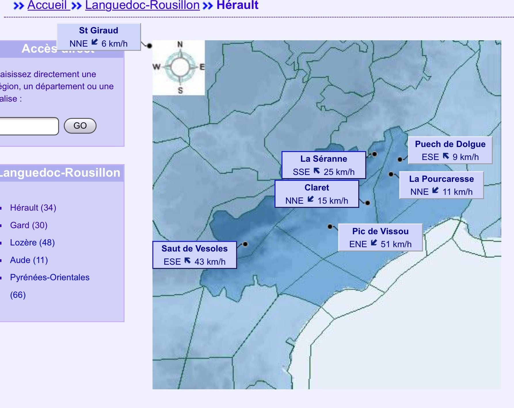
A snapshot from one of the regions I fly in in the south of france showing 20 min median winds. Gusts over a longer period along with temperature are also shown. The former can be three times the strength of the median. France has the luxury of a developed structure..Ireland has virtually none.
ps wind strength above 25kph are hospital visit, 45 kph morgue. Direction generally needs to be within 20 degrees of take off access.
Last edited by blind pew; 24th Nov 2021 at 07:49.
