


Windspeed / Direction Broadcasting

Thread Starter
Tabs please!


Joined: Jun 2004
Aviation Qualifications: PPL
Posts: 1,201
Likes: 1,098
From: Biffins Bridge
Windspeed / Direction Broadcasting
Hi all,
Does anyone know of a system that will measure wind speed and direction, average the values for a period and then broadcast it on an airband channel ? There has to be something better than overflying a small grass field at 1,800 feet, trying to spot the windsock and then deciding which way it is pointing.
Thanks in advance
Brian

Joined: Nov 2005
Aviation Qualifications: PPL
Posts: 12,458
Likes: 368
From: Wildest Surrey
All METARs broadcast on an ATIS are 10 min averages; unless prefixed by the word 'instant' all plain voice readings are 2 min averages.
Last edited by chevvron; 21st September 2020 at 06:50.


Joined: Mar 2008
Aviation Qualifications: ATPL
Posts: 345
Likes: 38
From: Lander, WY, USA
These guys make something like what you're after, they used to be called SuperAWOS, now evidently Potomac Aviation:
https://potomac-aviation.com/vlp/?gc...SAAEgIVU_D_BwE
There's some of these around the US, at smaller semi-rural fields that wouldn't normally get an "official" Weather Service/FAA AWOS or ASOS. You click three times on the CTAF frequency, and an automated voice broadcasts current conditions, like an ASOS, only not on a separate frequency. Works OK at light-use fields, but if much traffic on frequency with position reports, etc., it kind of clutters up the radio every time.
Looks like they go worldwide, but i don't have any idea about approval/certification, or such. And, may be more expensive than you' want for your private strip.

Joined: Feb 2001
Posts: 164
Likes: 2
From: UK
Does the farm strip have internet access? Home weather stations are fairly cheap and many connect to the internet where the data can be accessed by an App. Such a system would provide the additional benefit of making data available from some distance away, as long as a phone data signal was available. Or PC/tablet internet access.
Joined: Jul 2007
Posts: 812
Likes: 19
From: uk
With the widespread use of GPS these days - just fly up the runway at circuit height and this will allow you to compare the groundspeed with the airspeed and hence derive the wind speed component and decide on landing direction as appropriate!
Joined: Sep 2010
Aviation Qualifications: ATPL
Posts: 887
Likes: 235
From: by the seaside
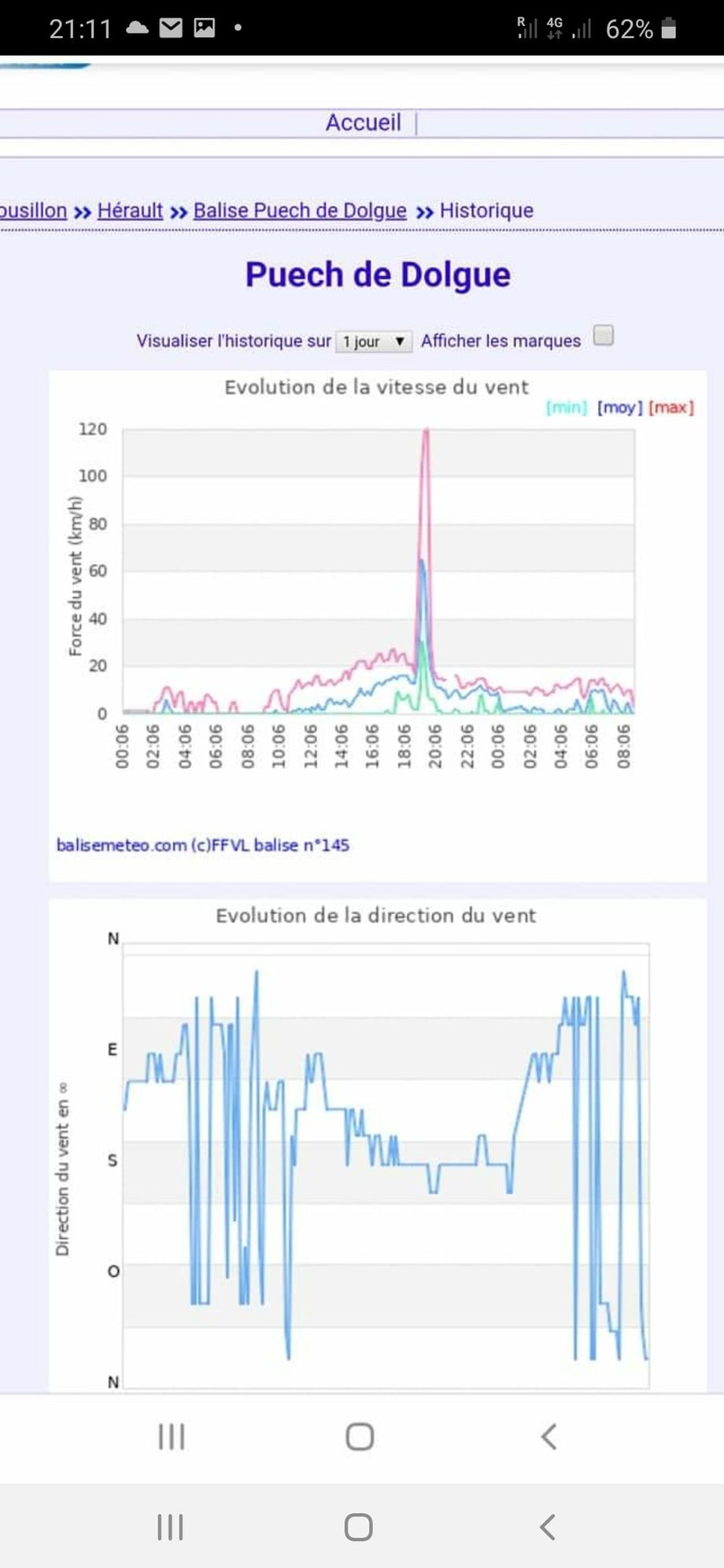
Ffvl
The french paragliding federation have a system of wind strength, direction and temperature balises which broadcast and are available on the internet. They give the median wind and the Maximum over a specific period. A late friend of mine installed a number of similar devices in South Africa. Sadly he lost his elevator on a power line.
The gps flyover observation is unreliable especially during high pressure systems with associated temperature inversions where the direction on either side of the layer can vary 180 degrees.
FFVL - Balises M�t�o
The gps flyover observation is unreliable especially during high pressure systems with associated temperature inversions where the direction on either side of the layer can vary 180 degrees.
FFVL - Balises M�t�o

Joined: Aug 2015
Posts: 599
Likes: 61
From: ex 5Y. Now G
Looks like a fun project. But I agree, with this comment:
Voice/radio would add a lot to cost, complexity and regulatory issues. Why not get it to update a webpage? Assuming that the location has mobile data coverage..
(I frequently fly into strips in which the windsock has long since been stolen or shredded by monkeys. I have often wondered about being able to drop some kind of smoke flare on the inspection pass. It would have to be designed so that it would not set fire to the grass!)
Does the farm strip have internet access? Home weather stations are fairly cheap and many connect to the internet where the data can be accessed by an App. Such a system would provide the additional benefit of making data available from some distance away, as long as a phone data signal was available. Or PC/tablet internet access.
(I frequently fly into strips in which the windsock has long since been stolen or shredded by monkeys. I have often wondered about being able to drop some kind of smoke flare on the inspection pass. It would have to be designed so that it would not set fire to the grass!)
Joined: Jul 2007
Posts: 812
Likes: 19
From: uk
blind pew: Your point is noted however there is no reason why the GPS can not be used to validate the runway choice on final.
My based strip has intersecting runways with trees nearby and the two windsocks are often 90 degrees different in certain prevailing wind directions.
My based strip has intersecting runways with trees nearby and the two windsocks are often 90 degrees different in certain prevailing wind directions.
Joined: Sep 2010
Aviation Qualifications: ATPL
Posts: 887
Likes: 235
From: by the seaside
Agreed on short final
If it�s part of your scan but flying paragliders with a normal speed of 15 knots for the last 20 years I�ve seen three different wind directions in around 1,000ft Vertical and wind reversal below 100ft whilst landing which hurt.
My last fixed wing pax flight in France was with the owner who had more than 1000 hours on type; I had the local paragliding site wind readings on my phone which he ignored. They pointed to a strengthening cross / tailwind into a small, one way strip with a mountain at the end. He messed the first final turn up due to tail wind and accepted my reluctant suggestion of flying the base leg from the opposite side which went well until he went unnoticed from strong tailwind to no wind, bounced and stuffed the stick forward before I could stop him. During the two subsequent bounces I blocked the stick and whilst I had stopped us breaking off the nosewheel and flipping on our back I hadn�t stopped him bending it and blocking the rudder. The final turn was below 150ft which is common on some of these fields including the local gliding club that I used to tow at where I did one low level go around purely because the drift on my 100ft final turn indicated a strong tail wind opposite to the windsock.
I find listening in flight to the 10 min reports from the wind stations invaluable as well as analysing the local diurnal effects and sea breeze. A couple of weeks ago N�mes taf was giving 40TCU which wasn�t far from the state of a cloud that I was watching whilst flying but playing it safe I landed. Getting home I checked historical data and found a gust which topped out at 120kph.
Joined: Dec 2001
Aviation Qualifications: ATPL
Posts: 3,766
Likes: 424
From: GA, USA
It appears some of you are severely overthinking this.
Final goal being a safe landing we need the actual wind close to our actual touch down point at the time of landing.
Final goal being a safe landing we need the actual wind close to our actual touch down point at the time of landing.
Joined: Dec 2016
Posts: 345
Likes: 75
From: Kipling's Twain
So a rho/theta anemometer on a 3m frangible pole feeding a strawberry pi which converts the data and sends it on a wfi to the nearest barn where a sensor picks it up.
I guess the tricky bit is the aeromobile telecoms point of view and the transmitting of the information. Over to the computer boffins here...
I guess the tricky bit is the aeromobile telecoms point of view and the transmitting of the information. Over to the computer boffins here...

Joined: Sep 2000
Aviation Qualifications: PPL
Posts: 365
Likes: 11
From: Dorset, UK
I take the view that there are only two choices of runway (on my strip anyway).
So feeling the wind on my face for take off and looking at heading and ground speed on approach is almost always good enough to decide which one. If it isn't then the wind is probably either straight across or too light to matter.
I have never got round to putting up a windsock, let alone something complicated and digital.
