


Predicting en-route winds

Thread Starter

Joined: Aug 2008
Posts: 39
Likes: 0
From: EGPD
Predicting en-route winds
Hello,
I am just wondering if anyone has a suggestion for an alternative method/website or data source that they use for forecasting en-route winds for the completion of a VFR navigation plog.
I currently use the Met Office F214 spot wind charts for deciding on the en-route wind for legs/whole flight as required - and it often tends to be slightly ambitions in terms of wind speed resulting in a lot of drift
I am just wondering whether there is a more accurate or improved way of getting en-route wind data for plogs?


Joined: Jan 2012
Posts: 395
Likes: 18
From: anywhere
Joined: Aug 2000
Posts: 1,214
Likes: 0
From: S Warwickshire

Joined: Oct 2004
Posts: 6,626
Likes: 12
From: UK
Welcome to the world of Meteorology, educated guesswork! The idea is that you learn to calculate or estimate the wind whist you fly and apply it as you go. No matter where you obtain the met forecast from, there is generally only one source of the basic data and in the UK that's the Met Office.
Joined: Dec 2011
Posts: 2,460
Likes: 0
The UKMO produces the F214 and F414.
All other wind data anybody is likely to see is almost certainly from the US-run GFS weather model, which is freely available via countless websites, like the one I posted.
But yes, the extent to which one uses this stuff for actual flying depends on the kind of flying one does. In modern times, you use a GPS so the wind is no longer relevant to navigation because you are getting a continuous lateral guidance along the programmed track. The wind remains relevant to fuel planning, and there are various rules people might make use of (e.g. ignore any forecast tailwind, plan with the full value of any forecast headwind, or whatever).
Thread Starter
Joined: Aug 2008
Posts: 39
Likes: 0
From: EGPD
Many thanks to everyone so far for these online resources, the more the better in my understanding of met and upper winds! Will try these out next time I fly and see if I can get better results! Peter - I have to say I've come across your own site on this forum before and have read several of your IFR trip reports - they are absolutely fascinating and certainly interesting to read to say the least 

I am just having a look now at the WeatherOnline charts for upper winds and not too sure how to work out the altitude for each chart. The charts are given at 950/900/850... and so on intervals but no height information is given - does anyone know how 950hPa relates to a height? I'm assuming it is the pressure decreases as altitude increases, but seems an odd way (for a pilot anyway) to present the data! Would one simply take, for example 900hPa from 1013hPa and *27ft for every hPa, to get say 3,051ft - or am I completely wrong?
Thanks for all the help & advice
Last edited by ABZ777; 22nd March 2012 at 23:51.
Joined: Dec 2011
Posts: 2,460
Likes: 0
It's approximate.
You might want to take 1013 as sea level, and work 27ft per millibar up from there. But that works only at low levels, and the 27ft/mb soon becomes 50ft or even more. The vertical scale on this skew-t gives you the general idea
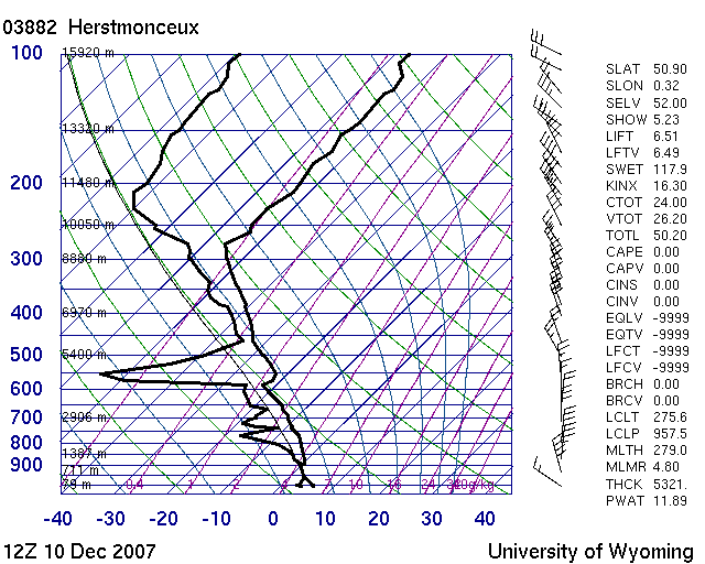
I don't know if there is an online converter for millibars to altitude, and in any case it would vary on the day according to the "thickness" property. Typically, 500mb is about 5300m (17000ft) and if you look at a typical MSLP chart you can see the thickness parameter shows in decameters e.g. here
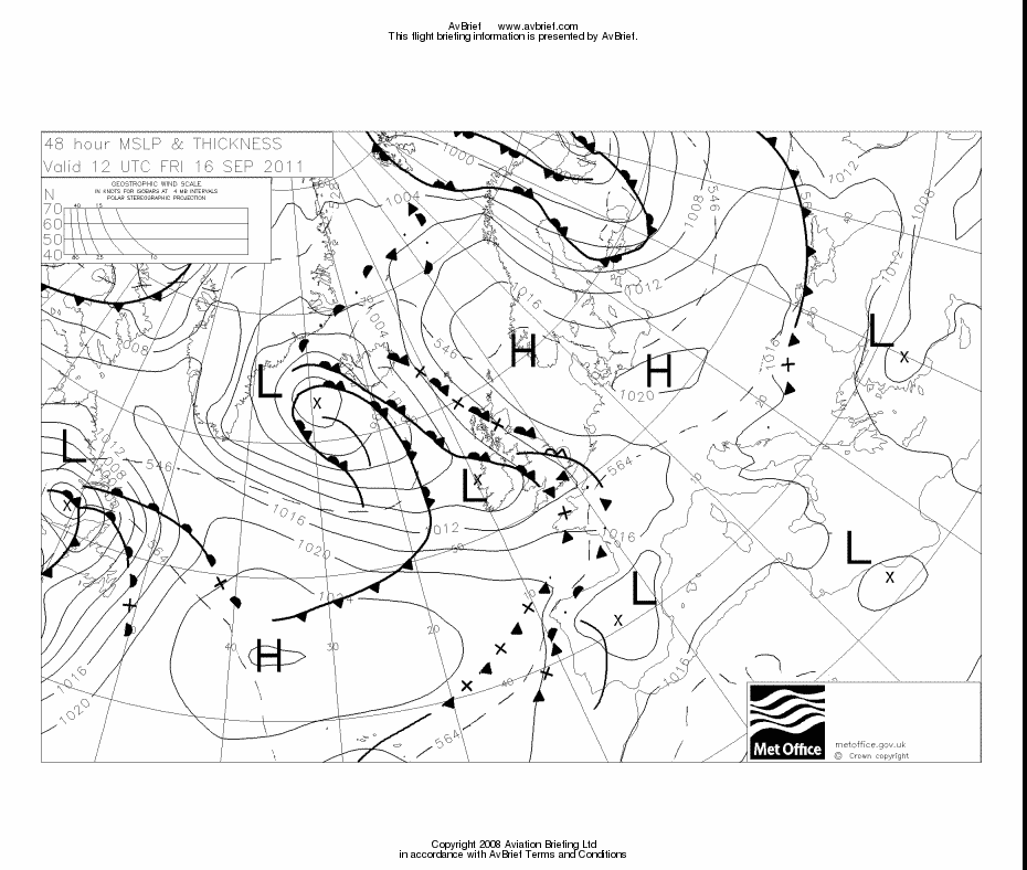
you see the "thickness" as a dashed line at 564 decameters and this is the 500mb surface. This is all affected by temperature also. But for wind estimates you don't need to be that accurate.
You might want to take 1013 as sea level, and work 27ft per millibar up from there. But that works only at low levels, and the 27ft/mb soon becomes 50ft or even more. The vertical scale on this skew-t gives you the general idea
I don't know if there is an online converter for millibars to altitude, and in any case it would vary on the day according to the "thickness" property. Typically, 500mb is about 5300m (17000ft) and if you look at a typical MSLP chart you can see the thickness parameter shows in decameters e.g. here
you see the "thickness" as a dashed line at 564 decameters and this is the 500mb surface. This is all affected by temperature also. But for wind estimates you don't need to be that accurate.
Joined: Jan 2012
Posts: 395
Likes: 18
From: anywhere
Yeah, just work on 1,500' for every 50hPa, good enough for GA altitudes.
It's a forecast of something that can only be measured by a radiosonde which has no means of measuring it's altitude other than pressure.
It's a forecast of something that can only be measured by a radiosonde which has no means of measuring it's altitude other than pressure.
Joined: Oct 2004
Posts: 6,626
Likes: 12
From: UK
I thought the sondes have a GPS, which gives you the altitude

In the UK all Sondes are operated by the Met Office so as I said before all data comes from a common source. There are satellite sensors that can track air mass movement and estimate vertical temperature and humidity using radiometry but they lack the accuracy of Sondes. Note the large GPS antenna top left of the Sonde. The Temp Pressure and Humidity sensors are on the vertical metallic strip. If you are interested in tracking Sondes they operate on 400-406 MHz and tracking software can be found here The telemetry data can be plotted using Google Earth.
Joined: Dec 2011
Posts: 2,460
Likes: 0
On a baloon, the wind is the GPS-derived ground speed. There is nothing else to do.
In a powered aircraft, calculating the wind requires
- GS (from GPS)
- track (from GPS)
- TAS (which requires IAS, altitude, and temperature)
- heading (from fluxgate magnetometer compass, etc)
A G296 cannot calculate the wind because has only the first 2. There is an E6B calculator in there into which you can enter the other 2 values manually. Most aviation GPSs have such a function. Most of the panel mounted IFR units can get the extra data supplied from an air data computer so you don't need to fill them in manually.
Joined: Jan 2002
Posts: 1,235
Likes: 0
From: Niort
That is correct you enter 2 items of data (or 4 if you are high) and get the actual wind - which is considerably more accurate than anything forecast - unless you are going to access sonde data whilst flying.....
Joined: Dec 2011
Posts: 2,460
Likes: 0
Sure, but why would you need to calculate the "exact" wind while flying?
All that matters when flying (for fuel endurance, ETA, etc) is the ground speed, and if you are expecting that to be significantly affected by the wind during your flight then the wind direction etc are also likely to be changing.
All that matters when flying (for fuel endurance, ETA, etc) is the ground speed, and if you are expecting that to be significantly affected by the wind during your flight then the wind direction etc are also likely to be changing.

Joined: Jan 2004
Posts: 5,658
Likes: 500
From: Canada
Sure, but why would you need to calculate the "exact" wind while flying?
All that matters when flying (for fuel endurance, ETA, etc) is the ground speed, and if you are expecting that to be significantly affected by the wind during your flight then the wind direction etc are also likely to be changing.
All that matters when flying (for fuel endurance, ETA, etc) is the ground speed, and if you are expecting that to be significantly affected by the wind during your flight then the wind direction etc are also likely to be changing.
For a longer cross country I always do an inflight wind calculation because if the wind is very different then what was forecast you can take all your preflight met printouts crumple them into a ball and throw them into the back of the airplane. It is now time get new weather and to start coming up with a plan B
Last edited by Big Pistons Forever; 23rd March 2012 at 18:31.
Joined: Dec 2011
Posts: 2,460
Likes: 0
One gets a pretty good idea from the MSLP charts.
What I tend to find is that in light-wind conditions (such as today's widespread high pressure) the wind can vary from say 10kt tail to 10kt head, and none of that was forecast. So one needs to build in a margin for that, e.g. 10% extra fuel even if no headwind at all was forecast.
And it can be totally different in both speed and direction between say 2000ft and say FL100.
In better defined conditions, where you have a definite head or tailwind, it can also vary by a lot, but e.g. a 40kt tailwind at FL100 is not likely to turn into a headwind, and if it does then you may need to land for fuel.
This is why, for long trips, a fuel totaliser linked to a GPS is so invaluable. You get a constantly updated ETA, and Landing FOB. It is one of the cheapest gadgets one can fit to a plane, and is one of the most useful for avoiding enroute doubt and enhancing safety. I would not fly anywhere for real without mine.
Joined: Jan 2004
Posts: 5,658
Likes: 500
From: Canada
Unforecasted head wind tail wind, or left instead of right cross wind means the front is nor where it was supposed to be. This usually happens when it moves faster or slow than forecast. Last week our forecast 30 kt tailwind was a 10 kt headwind . The " good VFR" destination weather also turned into a IMC until Inside the FAF ILS ")
. The " good VFR" destination weather also turned into a IMC until Inside the FAF ILS 