


ADF v. GPS

Thread Starter
Joined: Dec 2011
Posts: 2,460
Likes: 0
ADF v. GPS
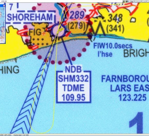
Here is a EGKA 20 NDB approach flown using the ADF, by hand, within the tolerance

Here is a EGKA 02 NDB approach flown using the GPS OBS mode (as DCT SHM), with autopilot tracking, 1nm full-scale (0.3nm FS is even better)
Compare and contrast, as they say
Here is a EGKA 02 NDB approach flown using the GPS OBS mode (as DCT SHM), with autopilot tracking, 1nm full-scale (0.3nm FS is even better)
Compare and contrast, as they say


Joined: Oct 2004
Posts: 6,626
Likes: 12
From: UK
The aim of both is to find the airfield; they both do that, one just provides a higher degree of accuracy in the process. Perhaps it would be more representative to show both plots hand flown! Presumably you used different runways to avoid coastal refraction!
Thread Starter
Joined: Dec 2011
Posts: 2,460
Likes: 0
The "different runways" is merely a case of not having matching GPS tracks saved
I will get some next time.
Sure both reach the runway but one could have reached the runway on a track of 270 (and hit the hill)
It is fortunate that the NDB error is in this case away from the terrain.
I will get some next time.
Sure both reach the runway but one could have reached the runway on a track of 270 (and hit the hill)
It is fortunate that the NDB error is in this case away from the terrain.
Joined: Jan 2006
Posts: 676
Likes: 0
From: london
You and I get the point, Peter. The problem is that there is still a generation of ex-RAF navigators/pilots/air-traficers out there, who are now embedded in the upper echelons of the CAA and EASA rule-making departments who still refer to extremely sophisticated panel mounted GPS panel mounted devices as "GPS wonder-boxes" as if they were the work of beelzebub, and no real substitute for non-precision NDB approaches flown with a stopwatch and the aid of a navigator.
Although i regularly fly the NDB procedure at my home base of Oxford, and am happy to do so as the surrounding scenary is sufficiently low not to worry me, the NDB 20 approach at Shoreham has the double gotcha of proximaty to the sea (with all the well known problems for NDB's) and high hills which scares the bejesus out of me.
Until the old guard at the CAA finally retire to tend their dahlia's, we're stuck with these ludicrous anachronisms.
Joined: Sep 2006
Posts: 3,113
Likes: 2
From: 23, Railway Cuttings, East Cheam
Until the old guard at the CAA finally retire to tend their dahlia's, we're stuck with these ludicrous anachronisms.
Thread Starter
Joined: Dec 2011
Posts: 2,460
Likes: 0
My point, not well made, is that you can fly a published NDB procedure using a GPS.
So I have nothing against NDB procedures, or VOR procedures for that matter
I don't see NDBs going away either, for many years. They are OK as locators and are a lot cheaper to keep going than VORs.
Whopity, I know what you are getting at but I am 100% sure one would hit terrain if one flew to EGKA on a track sufficiently different from the 20 inbound at the MDH I don't think that merely following the DME-based stepdowns would protect the obstacle clearance.
100% legal for private ops. Only on AOC ops you have a procedure manual which specifies how things should be done. In private ops, the regs mandate equipment to be carried, not equipment to be used.
So I have nothing against NDB procedures, or VOR procedures for that matter
I don't see NDBs going away either, for many years. They are OK as locators and are a lot cheaper to keep going than VORs.
Whopity, I know what you are getting at but I am 100% sure one would hit terrain if one flew to EGKA on a track sufficiently different from the 20 inbound at the MDH
I don't think that merely following the DME-based stepdowns would protect the obstacle clearance.
Is that actually legal?
Joined: Oct 2004
Posts: 6,626
Likes: 12
From: UK
ex-RAF navigators/pilots/air-traficers out there, who are now embedded in the upper echelons of the CAA and EASA rule-making departments
My point, not well made, is that you can fly a published NDB procedure using a GPS.
Thread Starter
Joined: Dec 2011
Posts: 2,460
Likes: 0
There are two approaches (no pun intended) to this.
One is to fly the full published procedure, but using GPS navigation. That is usually what I do, and it is what ATC expect (because they don't know, nor do they care, how you actually navigate around the procedure). I would call that "flying the NDB procedure".
The other is to fly some form of abbreviated procedure, whereby one just intercepts the inbound track like it was a localiser. That is obviously stupid if you told ATC that you are flying the procedure. I would also bet that obstacle clearance would not be assured in all possible cases worldwide. But it is tempting because the reason for the "classical" IFR business of tracking to the beacon and then tracking outbound is because in the goode olde days there was no straightforward way to self intercept an inbound track. GPS makes it trivial.
Joined: Nov 2000
Posts: 3,443
Likes: 1
From: Cambridge, England, EU
The other is to fly some form of abbreviated procedure, whereby one just intercepts the inbound track like it was a localiser.
Joined: Oct 2010
Posts: 382
Likes: 0
From: Belgium
My point, not well made, is that you can fly a published NDB procedure using a GPS.
If it is VFR panel mount or hand held, it is a great addition to situational awareness while flying the needle as a primary indication.
What struck me in your comment was your point that the NDB approach can be flown within tolerance (with the error on the wrong side) and still hit terrain. Is the Shoreham NDB approach procedure ill-conceived ?
The other is to fly some form of abbreviated procedure, whereby one just intercepts the inbound track like it was a localiser.
nope no rules
Thread Starter
Joined: Dec 2011
Posts: 2,460
Likes: 0
So wot about using GPS to position for the ILS then, in the absence of radar vectors?
With a non radar airport, the default ATC expectation will be that you will track to the beacon, perhaps go around the hold, fly outbound, and intercept the LOC. If you asked for a direct intercept, it should be OK of course, but IME they are a lot less likely to agree to it. Lydd is a classic case of this, with its silly "half-hour" DME arc. I have on occassions asked for a direct intercept when booking the ILS with a phone call but when I got there they wouldn't entertain it.
I am no expert on procedure design but there has to be a difference between a procedural NDB/VOR/etc IAP and a radar-vectorable ILS IAP. The former could potentially have its obstacle clearance designed to be assured only when you fly the full published version. The latter must be designed so that you are safe within the entire radar vectoring area, and if you do a self intercept and obey the limits of the radar vectoring area (which is published) then you should be OK. Obviously at Lydd, Manston, Bournemouth there is nothing to hit at the ILS platform for many miles around
but in principle this is dodgy e.g. you must not descend to the ILS platform until firstly inside the MSA (shown on the 25nm rad circle on the plate) and then secondly inside the radar vectoring area, but your GPS is unlikely to depict the boundary of the latter. That is why, in a non radar environment, it seems obvious that you should be flying the full published procedure even to a radar vectorable ILS, unless the ILS platform is above the SSA.
If it is VFR panel mount or hand held, it is a great addition to situational awareness while flying the needle as a primary indication.
What struck me in your comment was your point that the NDB approach can be flown within tolerance (with the error on the wrong side) and still hit terrain.
Joined: May 2001
Posts: 10,804
Likes: 1
apart from having an panel mounted approved GPS IFR installation. They would only do that if your flight plan indicates /G
I have done a few with just using the NDB on the field and the 1 in 60 rule and the ILS DME
If I was the wrong side for a straight in I would ask for self position for the ILS.
The ATCO has no clue at all about whats on the equipment list on your flight plan.
Once your taking to a controller you can ask for what you like and its up to them to say yes or no. As a none qualified VFR pilot you can request an ILS and they may give it to you. But its up to you to remain legal which is more than likely impossible if you are solo.
Joined: Oct 2010
Posts: 382
Likes: 0
From: Belgium
you don't need that either. I have done a few with just using the NDB on the field and the 1 in 60 rule and the ILS DME
You're at 3000 MSL, flying solo at 135 KTS IAS, a heading of 360, the wind likely to be strong (about 30 KTS) and from 270-ish. Its full IMC, with a 1400ft ovc ceiling.
You've just past the last en route waypoint "BLIMY". Your DME indicates 15 NM to the NDB, your ADF needle points 40� to the left.
Your little chat with ATC results in them asking you to position yourself at the 6 NM center fix.
What heading do you turn to, using your 1 in 60 rule ?
[My point being that I would question mental arithmetic being good airmanship in this situation. And if it is VMC, then you don't need to position on some center fix, you could fly directly to the airport.]
But its up to you to remain legal
@peterh :
If it is VFR panel mount or hand held, it is a great addition to situational awareness while flying the needle as a primary indication.
Last edited by proudprivate; 11th February 2012 at 20:02.
Thread Starter
Joined: Dec 2011
Posts: 2,460
Likes: 0
I'd say 2 things:
AIM is not law. The FARs are the law.
The equipment to conduct the flight is required to be carried. No law says it must be used to actually perform the navigation.
FWIW, the above is a regular topic which has been done to death on US pilot forums over more years than I have been flying.
I wouldn't say that a handheld GPS is particularly necessarily good for this kind of thing, partly because most of them don't have an OBS mode.
Joined: May 2001
Posts: 10,804
Likes: 1
Just because you are talent limited doesn't mean the rest of us are.
I have over 8000 instrument approaches how may do you have?
There is no legal requirement for G reg aircraft to have a panel mounted GPS to do what I am suggesting.
There are actually a number of ways you could do it. One of which is to fly a 7 DME arc (which is also a piece of piss). Turn in to establish with 5 deg to turn in to runway heading.
Or you could point it at the field and then with 7 miles to run take a 45deg wind adjusted heading then turn to intercept at 6 miles.
The actual point you should be asking is if I am above MSA when I am doing this. If I am it really doesn't matter what I do if so cleared. If I am under MSA I really am quite silly to attempt to do it.
If you give me the runway QDM I can give you the heading if you really want.
But to be honest we need to do this calc anyway so that we can work out our min distance to run to make sure we arn't going to get hot and high.
We are also working out our decent profile as well so we get continuos decent profile all at the same time. Some have boxes of tricks to do it, some of us don't have that so do it in our heads. The reason why I sometimes do a in the head job is because its a pain in the arse getting the centerfix into the gps. It really isn't a special ability of mine, an old boy taught me how to do it years ago. And I think he got taught how to do it when he was flying Shackletons.
Last edited by mad_jock; 11th February 2012 at 21:16.
Joined: Oct 2010
Posts: 382
Likes: 0
From: Belgium
Just because you are talent limited doesn't mean the rest of us are.
Neither the 7 DME arc, nor flying directly to 7 DME point 40� would have you complying with an ATC clearance "Direct 6NM center Fix".
I have over 8000 instrument approaches how ma[n]y do you have?
I agree of course that if you are above MSA within the MSA radius, a CFIT is excluded and a collision hazard is virtually non-existent as ATC would not agree with a direct 6 DME center fix if anyone else was likely to be in the neighbourhood of your flight path.
This whole discussion got out of hand when you said "nope, no rules". Which, after reading through the AIM and the online US CFR, might actually be true, because all this nonsense about panel mounted GPS systems only applies to US airspace (see below).
@ Peterh : I couldn't find the relevant references you were referring to on the US forums.
Interestingly enough: Part � 61.65 Instrument rating requirements tells us that we have to study the AIM as regards operations under IFR, but nowhere does it say that you have to abide by them after passing your IR check ride
However, the AIM publication itself says :
"This manual contains the fundamentals required in order to fly in the United States NAS. It also contains items of interest to pilots concerning health and medical facts, factors affecting flight safety, a pilot/controller glossary of terms used in the ATC System, and information on safety, accident, and hazard reporting"
but Part 91 doesn't mention mention either the word AIM or the word GPS

Then again there must be something in the statutes of the FAA that allows them to enforce 1-1-19, because the first paragraph of chapter 1 reads:
Various types of air navigation aids are in use
today, each serving a special purpose. These aids have
varied owners and operators, namely: the Federal
Aviation Administration (FAA), the military services, private organizations, individual states and
foreign governments. The FAA has the statutory
authority to establish, operate, maintain air navigation facilities and to prescribe standards for the
operation of any of these aids which are used for
instrument flight in federally controlled airspace.