


Infringements of the Heathrow CTR

 Were they relying on it for primary navigation?

I bet you 60% of the violating pilots had GPS
But most people on here seem to be of the view that is how it should be.
Join Date: Aug 2003
Location: Surrey
Posts: 1,217
Likes: 0
Received 0 Likes
on
0 Posts
Slim_Slang, I'll take your bet. I doubt any of the 4 others were actively using a GPS. Or if they were, that it was a nav error as compared to a planning or understanding issues (some people, believe it or not, don't seem to understand you need a clearance to fly in the TMA or CTR )
)
Roffa - The LHR point is probably about the 'large' surface area of the zone vs. US airports - A point that is done to death and not that relevant in discussing why PPLs bust clearly marked (if large) zones.
)Roffa - The LHR point is probably about the 'large' surface area of the zone vs. US airports - A point that is done to death and not that relevant in discussing why PPLs bust clearly marked (if large) zones.
Last edited by mm_flynn; 20th Jul 2007 at 19:37. Reason: lazy description fixed as pointed out
Thread Starter
Join Date: Dec 2005
Location: west london
Posts: 104
Likes: 0
Received 0 Likes
on
0 Posts
mm flynn, you're quite right about the clearance bit, but don't confuse the TMA airspace with the CTR airspace.....CTR GL to 2500 feet, TMA, 2500 to FL245.

Join Date: May 2006
Location: UK
Posts: 796
Likes: 0
Received 0 Likes
on
0 Posts
Roffa - The LHR point is probably about the 'large' surface area of the zone vs. US airports - A point that is done to death and not that relevant in discussing why PPLs bust clearly marked (if large) zones.
The eastern edge probably isn't going to change.
The northern boundary is consistent with ensuring traffic climbing out of LHR and Northolt on SIDs in to the airways system at the minimum climb gradient remains inside CAS.
Same with the southern boundary for LHR traffic, although there might be leeway bringing it north a bit.
You might be able to trim a mile or two in at the corners but that's about all.
Doesn't seem overly stupid to me.
Join Date: Feb 2003
Location: London
Posts: 39
Likes: 0
Received 0 Likes
on
0 Posts
Pilots will naturally select the shortest route..and will route close to CTR boundaries. The size of EGLL CTR means that an infringer is thankfully spotted and avoided before it becomes a collision threat. Having said that, there are investigations into reducing the CTR boundaries to the East and West of LL in a bid (amongst other things) to give more freedom to White Waltham, Fairoaks and other GA.
Spoon PPRuNerist & Mad Inistrator
I just had to mention that gross navigational errors are as old as aviation!
Anyone heard of "Wrong-way Corrigan"?
Now that's one gross navigational error 
SD
Anyone heard of "Wrong-way Corrigan"?
Douglas Corrigan became a legendary aviator, not because of his accomplishments as a pilot but rather because of a supposed navigational error. In 1938, Corrigan "mistakenly" flew from New York to Ireland--when he was supposed to be flying from New York to California--because he seemingly misread his compass. For Americans, who were caught in the midst of the Great Depression, Corrigan's antic provided a great deal of humor and uplift and he became a national folk hero. To this day, Corrigan's nickname, "'Wrong Way' Corrigan," remains a stock colloquial phrase in popular culture. People use it to describe anyone who blunders and goes the wrong way, particularly in sporting events. Nevertheless, as much fun as Corrigan's incident provides, many people do not understand all the complexities of his story, nor do they appreciate the fact that he was a sound and accomplished pilot.
SD
Join Date: Jun 2003
Location: EuroGA.org
Posts: 13,787
Likes: 0
Received 0 Likes
on
0 Posts
This pilot claimed he had "erronously programmed his GPS".
Not really possible with a moving map GPS.
Did the unit he used get looked at?
Or did the "investigators" just take his word for it, rubbed their hands in glee when they heard the 3-letter word, and wrote up the report?
Not really possible with a moving map GPS.
Did the unit he used get looked at?
Or did the "investigators" just take his word for it, rubbed their hands in glee when they heard the 3-letter word, and wrote up the report?
Avoid imitations
Join Date: Nov 2000
Location: Wandering the FIR and cyberspace often at highly unsociable times
Posts: 14,578
Received 435 Likes
on
229 Posts
I know a VC-10 navigator who completely missed the UK on the return from the USA! It was caused by programming in 70 degrees of magnetic variation instead of 7 degrees.
Join Date: Jan 2001
Location: He's on the limb to nowhere
Posts: 1,981
Likes: 0
Received 0 Likes
on
0 Posts
OK, so now you have told us why you think the edges are there.
Describe the edges and any corners of the London Surface area so it might be easily understood by somebody in a light aircraft navigating by looking out of the window at the surface. Stupid comes in many varieties.
IO540, has anybody else ever got it right? You know, maybe just the once?
mm_flynn, you need to read my bet properly
Thread Starter
Join Date: Dec 2005
Location: west london
Posts: 104
Likes: 0
Received 0 Likes
on
0 Posts
IO540, we are not "Investigators" and neither do we take delight in having to follow these things up. The pilot was simply asked to contact the supervisor. He would've been asked if he'd realised that he had penetrated controlled airspace and, dependant upon his answer, asked to explain the reason for that unauthorised penetration. More often than not, if there was no erosion of separation between aircraft, controllers are reluctant to go into paperwork - we have enough to do as it is. A simple explanation of the airspace and procedures is enough. That said, a lot depends on the pilot's attitude. If he comes out fighting, with an agressive attitude, denying everything, then radar replays and paperwork will undoubtedly follow. We are here to help, educate and provide a safe service to ALL airspace users.
A17
A17
Join Date: May 2006
Location: UK
Posts: 796
Likes: 0
Received 0 Likes
on
0 Posts
Slim wrote...
The London Zone is no different than all the other CAS in the UK, why pick on it?
p.s. before mentioning the States, they're not totally perfect either...
Describe the edges and any corners of the London Surface area so it might be easily understood by somebody in a light aircraft navigating by looking out of the window at the surface. Stupid comes in many varieties.
p.s. before mentioning the States, they're not totally perfect either...
Join Date: Dec 1999
Location: LHR/EGLL
Age: 45
Posts: 4,392
Likes: 0
Received 0 Likes
on
0 Posts
Slimslag,
With all due respect, Roffa has told us exactly why the edges are where they are; to provide separation between a/c flying on published instrument procedures (SIDs, ILS etc) and a/c outside controlled airspace.
Sorry, can you rephrase this please? I'm really not sure what you're getting at here. 
If navigating around the edges of the CTR/TMA is too difficult (which is the impression I'm picking up from your remark above), then a well orchestrated letter-writing to CAA DAP would I'm sure start the process of expanding Class A airspace to make the boundaries more easy to understand whilst flying in a light a/c navigating by looking out the window.....
OK, so now you have told us why you think the edges are there.
Describe the edges and any corners of the London Surface area so it might be easily understood by somebody in a light aircraft navigating by looking out of the window at the surface. Stupid comes in many varieties.
If navigating around the edges of the CTR/TMA is too difficult (which is the impression I'm picking up from your remark above), then a well orchestrated letter-writing to CAA DAP would I'm sure start the process of expanding Class A airspace to make the boundaries more easy to understand whilst flying in a light a/c navigating by looking out the window.....
Join Date: Aug 2003
Location: Surrey
Posts: 1,217
Likes: 0
Received 0 Likes
on
0 Posts
No not perfect - Looks like they have had some help from the UK.
On a serious note look here (put EWR in on the search) for the more traditional wedding cake structure.
In both airspace designs (LAX and EWR) the amount of CTR is small compared to London and steps up fairly sharpish. Do US jets climb better? Or is it a tighter airspace (possibly with less tolerance for EFOT)?
.On a serious note look here (put EWR in on the search) for the more traditional wedding cake structure.
In both airspace designs (LAX and EWR) the amount of CTR is small compared to London and steps up fairly sharpish. Do US jets climb better? Or is it a tighter airspace (possibly with less tolerance for EFOT)?
Join Date: May 2006
Location: UK
Posts: 796
Likes: 0
Received 0 Likes
on
0 Posts
Much of the irregular shape of UK airspace stems from pressure from various user groups to keep it to the minimum required.
It would be possible no doubt to get more circular as is often the case in the States, but I reckon overall more airspace would be used up in the process.
Cake and eat it, so to speak.
Looking at the NYC airspace, they have smaller surface areas but also shelfs with lower base levels than we'd use here. What significant use a 500ft shelf, or a 1100ft, 1200ft or 1500ft one over a built up area is in an average GA single is debatable but I suppose they can at least say it is there.
Join Date: Oct 2005
Location: England
Posts: 518
Likes: 0
Received 0 Likes
on
0 Posts
whilst I agree that gps should be taught, I very much doubt that, it will ever replace being able to nav via tradition methods, especially during a nav x
At least the student had sense enough to contact D & D
mm flynn's comment, I'm afriad you'd lose your bet, I was informed, that most infringers are cirrus pilots, so, even with all that expensive technology
At least the student had sense enough to contact D & D
mm flynn's comment, I'm afriad you'd lose your bet, I was informed, that most infringers are cirrus pilots, so, even with all that expensive technology
Join Date: Aug 2003
Location: Surrey
Posts: 1,217
Likes: 0
Received 0 Likes
on
0 Posts
Cirrus pilots must just be lucky that they never infringe near anyone else given that they are 'most of the infringers'
.While blind faith in any box of tricks (i.e. GPS) or being a one trick navigator are problems, the lack of acceptance of the vast improvement in situational awareness afforded by panel mounted moving map systems is silly. Maybe commercial pilots should be made to use DR to satisfy their PRNAV requirements any time they are in sight of the surface if navigating using electronics is such a problem
 .
.
Join Date: Jan 2001
Location: He's on the limb to nowhere
Posts: 1,981
Likes: 0
Received 0 Likes
on
0 Posts
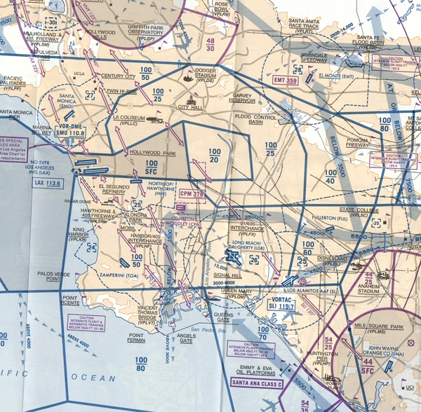
If you want to bring the States into it, take a closer look at that chart you cited of a far busier area than London. There are published VFR routes across the surface area, one of which doesn't even need a call to Tower. The area to the east is also rather small. You also get good radar service from SOCAL, always helps keep the controllers in the loop.
Gonzo, I think there is an argument that CAS might be made a little larger than neccessary in order to make the edges more easily to visualise using surface features. I could cite the PHX surface area, which is busier than LHR and isn't far off the size of LHR, but which I could describe to you by surface feature in the way requested in my request to Roffa. I really don't think that was a difficult concept.
What size surface area is neccessary is a matter for argument, and I don't think LHR controllers have a monopoly in that discussion. Remember, it's not how big it is, it's what you do with it

Anyway, it's been done before, and a very helpful LHR controller who quickly demonstrated empathy with the VFR pilot explained it very well last time.
I'm off on hols
Last edited by slim_slag; 21st Jul 2007 at 08:08.