


Any flying geologists out there?!?

Thread Starter
Join Date: Mar 2006
Location: On a roll...
Posts: 342
Likes: 0
Received 0 Likes
on
0 Posts
Any flying geologists out there?!?
Listen, I'm a professional geologist & amateur pilot & was wondering if anyone has managed to successfully combine their interests in flying & geology (or similar), either actually making money out of it or at least paying for their flying?
BFA
BFA


Join Date: Sep 2005
Location: North of South
Posts: 831
Likes: 0
Received 0 Likes
on
0 Posts
I would have thought igneous would be better than sedimentary due to its porous and aerodynamic qualities when cruising at 110kts , however I may be wrong any thoughts
Blah Blah Blah
Join Date: Jan 2006
Location: Malmesbury VRP
Age: 48
Posts: 927
Likes: 0
Received 0 Likes
on
0 Posts
Thread Starter
Join Date: Mar 2006
Location: On a roll...
Posts: 342
Likes: 0
Received 0 Likes
on
0 Posts
Gcloyer: Cheers....nice articles. Lucky gits. Didn't know about the Flying the Rim book either...will have to go order.
What's interesting though is that there is always a separate pilot & geologist!
MDP: As for optimal flying rocks, it would have to be a good pumice or vuggy chunk of coral for me....highly practical for floatplane operations of course!!
What's interesting though is that there is always a separate pilot & geologist!
MDP: As for optimal flying rocks, it would have to be a good pumice or vuggy chunk of coral for me....highly practical for floatplane operations of course!!
Blah Blah Blah
Join Date: Jan 2006
Location: Malmesbury VRP
Age: 48
Posts: 927
Likes: 0
Received 0 Likes
on
0 Posts
BFA
You have the formula. Get yourself a commercial license and you are good to go. Employers can have a pilot and geologist for the price of one employee.
You have the formula. Get yourself a commercial license and you are good to go. Employers can have a pilot and geologist for the price of one employee.
Join Date: Apr 2004
Location: UK
Posts: 74
Likes: 0
Received 0 Likes
on
0 Posts
I'm a flying geologist! Doing research on rivers and volcanic flows, have a NZ PPL, not making any money or anything by flying but when I was in NZ working on the mudflow from Mt Ruapehu I hired a 172 a couple of times and a supercub another, took it up to the crater lake and flew up and down the river. In fact a couple of pics I took got published in UNESCO "world heritage review" magazine!
Crater lake

Whangaehu Fan
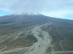
so sort of combining my interests...!
Crater lake
Whangaehu Fan
so sort of combining my interests...!

Join Date: Oct 2006
Location: Brussels - Twin Comanche PA39 - KA C90B
Age: 51
Posts: 647
Likes: 0
Received 0 Likes
on
0 Posts
This might help ?


Diamond Twin Star adds MPP family
By Brian Walters
June 21, 2007
Aircraft
Derived from the Dimond DA42 Twin Star widely used by flying schools, the DA42 MPP is developing into a family of aircraft that are capable of carrying all manner of sensors. That accounts for the rather strange shapes on the nose or beneath the fuselage that accommodate devices that tailor the MPP for specific tasks.
The example that has a rather unusual radome on the nose is intended to carry out photogrammetry missions carrying a Microsoft UltraCamX large-format digital camera.
Data from the camera can be transferred via cable into the CX data system in the rear of the aircraft�s cockpit.
Close by, another MPP is designed to carry a laser-scanning pod weighing up to 100 kilograms (220 pounds). This can handle a wide range of tasks including covering flood scenarios, providing digital surface and terrain modeling or helping power line maintenance.
Thread Starter
Join Date: Mar 2006
Location: On a roll...
Posts: 342
Likes: 0
Received 0 Likes
on
0 Posts
Flying Geologists
Hmmh, now with the uber-loitering endurance on a DA42 with fancy kit underneath you could do some very interesting things...
Tell you what got me thinking....
Chartered a C210 in the Australian Outback last year to go & shoot some footage of Lake Eyre (an analogue of a petroleum reservoir I was working on in Algeria, if you must know...) & the owner of the company who was flying us told me that if I went off & got myself an Australian CPL he would probably give me a job on the spot.
Over-qualified pilots (even prepared to go & live in the desert!) are ten-a-penny, but it was the geologist bit he was interested in...
I should probably point out I have 250HTT & only a PPL.
Join Date: May 2001
Location: 75N 16E
Age: 54
Posts: 4,729
Likes: 0
Received 0 Likes
on
0 Posts
Fugro Airborne Surveys (http://www.fugroairborne.com/) do gravity and magnetic surveys. Not quite geology, more geophysics but none the less related.
Thread Starter
Join Date: Mar 2006
Location: On a roll...
Posts: 342
Likes: 0
Received 0 Likes
on
0 Posts
Geo-fizzing with wings on...
That sort of gig would seem an obvious one, except from what I can see it's very much you're one or the other....considering the training required for either not surprising I s'pose!!
I am actually more of a geophysicist than geologist, so know about that game a little bit...gravmag is pretty mind-bending stuff!
Wonder if there's a niche market in & around the Big Boys like Fugro though?!?
Perhaps I should punt this out onto the Pros corner...??
I am actually more of a geophysicist than geologist, so know about that game a little bit...gravmag is pretty mind-bending stuff!
Wonder if there's a niche market in & around the Big Boys like Fugro though?!?
Perhaps I should punt this out onto the Pros corner...??
Thread Starter
Join Date: Mar 2006
Location: On a roll...
Posts: 342
Likes: 0
Received 0 Likes
on
0 Posts
Aerial geology....rock your world?!?
A few months, I posted asking if there were �any flying geologist outs there� (original link is below) & got back a few replies�. well, at least no-one told me to pi$$ off, which was something� in fact, there were a couple of nice ideas!
Anyway, since then, I�ve been thinking some more about the whole wasted link between flying and What�s Below.
Which is REALLY weird if you think about it�
Now, what I�m talking about is not your standard �flightseeing� nor digital surveying either�..as I think I said in the other post, more using the plane as a �tool� to explain what�s going on in front of you.
What I�d like to know is there anyone out there who would be interested in this kind of idea�.either running on an ad hoc basis among a group of people interested in the subject or more seriously??
There are several places where this might work in the UK, including one �world-class� location with half a dozen airfields in striking distance�
Please PM me if you�re interested!
Link to original post:
http://www.pprune.org/forums/showthread.php?t=284101&highlight=flying+geologists
Cheers
BFA
