


Erasing Safety?


Another one that’s presumably going to disappear from the charts.

And another.
Sunfish: On your favourite EFB, you should be able to tick an ‘ALA’ box that will add them to the map overlay, notwithstanding that the safety bureaucracy has airbrushed them out of history. Whether they are in any fit state to use is, as always, at the users’ risk.
alphacentauri, looking at the legend on my OzRunways chart, the relevant section of which looks like a scan of the WAC chart legend, there are a few different airfield symbols, including the following:
-A circle with a thin inner concentric circle, which represents "Aerodrome - licenced",
-A circle without that thinner concentric circle, representing "Aerodrome/ALA - verified Airservices has a responsible person registered for the location and associated information confirmed"
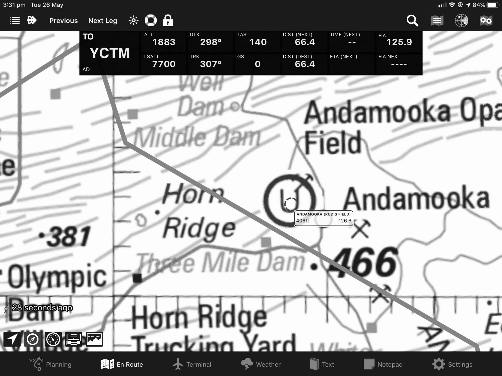
-A broken circle with 5 breaks in the outline, representing "Aerodrome/ALA - Unverified Airservices has not been advised of a responsible person for this location. Status and serviceability are unknown."
I can't see a reference to the U indicating "unverified" on any chart legends, instead the broken circle is used to indicate an unverified ALA. The same chart legends do use a U to indicate ultralight aircraft activity.
-A circle with a thin inner concentric circle, which represents "Aerodrome - licenced",
-A circle without that thinner concentric circle, representing "Aerodrome/ALA - verified Airservices has a responsible person registered for the location and associated information confirmed"
-A broken circle with 5 breaks in the outline, representing "Aerodrome/ALA - Unverified Airservices has not been advised of a responsible person for this location. Status and serviceability are unknown."
I can't see a reference to the U indicating "unverified" on any chart legends, instead the broken circle is used to indicate an unverified ALA. The same chart legends do use a U to indicate ultralight aircraft activity.
Lead Balloon that's ridiculous. You'd have a symbol on a chart that for 20 years hasn't been verified as even being an airport any more. Assuming you're a lawyer, based on your liberal use of legalistic codswallop, you'd have a field day if a pilot pranged an aeroplane and worse hurt someone if they landed in a ditch across a airstrip and flipped it while said airstrip was in ERSA but not under continual review.
You’re not paying attention, Cap’n (as usual).
The current charts published by Airservices have a symbol on them that is not described in the legend: An unbroken circle with a “U” in the middle. According to alphacenturi, that means the place is “unverified”. And the place is, apparently, going to be removed entirely from the chart.
The current charts published by Airservices have a symbol in the legend for an “Aerodrome/ALA unverified”: A broken circle.
Why are the charts not marked in accordance with the legend? Because the left hand doesn’t know what the right hand is doing.
There are unverified ALAs everywhere. That’s why there’s a symbol for them in the legend on the current charts published by Airservices. The reason they are marked as “unverified” is to make clear that their use is at the users’ risk. I don’t know who you reckon is going to have a ‘field day’ when someone has a prang using an unverified ALA, but I can rarely fathom what’s going on in your head.
I don't care about that minor anomaly. Do keep up. I was referring to your statement:
If it's not current and updated regularly by a person who is held responsible for said info, get it off the charts.
notwithstanding that the safety bureaucracy has airbrushed them out of history.
“Get it off the charts”? Spoken like a person who’s not spent much time flying around the outback in light aircraft.
Confusing aerodrome symbology on current charts a “minor anomaly”? Spoken like a person who’s not spent much time flying around the outback in light aircraft.
I’d make an educated guess that you’ve not spent much time flying around the outback in light aircraft, Cap’n. Must be distressing sharing a country with pilots that have.
Better that a pilot in the middle of nowhere never knows that there’s an unverified ALA within gliding range, because the unverified ALA might not be suitable. Best to do a forced landing somewhere else. It’s all about safety, doncha know!
Last edited by Lead Balloon; 26th May 2020 at 08:06.
Thread Starter
Does anyone not see the Kafkaesque absurdity in this action? The airfield is marked with a U for unverified. Well and good. However the absence of an ERSA entry leaves me with no contact information if I want to find out more. Furthermore, I would have thought the basic information of lat and lon, plus elevation, plus a few other details is/was/ accurate unless an earthquake has intervened. Even an entry explaining what WAS there would be useful.
Its bizzare, “there is an airstrip here, but we won’t tell you anything about it, nor how to find out more”. This is a safety hazard. In the absence of data pilots might not use them when they should. Furthermore, gossip and second hand information will replace ERSA an ERSA entry. This is a hazard.
Its bizzare, “there is an airstrip here, but we won’t tell you anything about it, nor how to find out more”. This is a safety hazard. In the absence of data pilots might not use them when they should. Furthermore, gossip and second hand information will replace ERSA an ERSA entry. This is a hazard.

*sigh*.
Sunfish: There is no ERSA information for these places for Airservices to publish because Airservices is unwilling or unable (usually practically unable) to find anyone to provide and take responsibility for the information. That is precisely why Airservices wants to delete any reference to the places from AIP. (I’d pay folding money to watch you and them in a room ‘discussing’ this stuff.)
Here’s what you should be lobbying for, Sunfish: The retention and publication of unverified ALA locations on AIP maps. At least then you’d know where there might be a usable landing area, but you would remain responsible for the consequences of use. That’s PRECISELY WHY THERE’S AN “UNVERIFIED AERODROME/ALA” symbol on the legend for these maps!
Its bizzare, �there is an airstrip here, but we won�t tell you anything about it, nor how to find out more�. This is a safety hazard. In the absence of data pilots might not use them when they should. Furthermore, gossip and second hand information will replace ERSA an ERSA entry. This is a hazard.
Sunfish makes a pprune post whining about "Erasing Safety".
So AirServices put it on the map, but put a note at the bottom saying data could be unreliable
So Checklist Charlie complains about AirServices not giving reliable data.
So they put an 'Unverified' identifier on the map so everyone will be happy.
Except they arn't cause some people have nothing else in their lives to whine about.
And here we are.
Originally Posted by Balon
I’d make an educated guess that you’ve not spent much time flying around the outback in light aircraft, Cap’n.
Have you put in a document change request to correct this shockingly dangerous situation where the WACs have a un-legended symbol, being a circle with a U in it?
Originally Posted by Sunfish
Furthermore, gossip and second hand information will replace ERSA an ERSA entry. This is a hazard.
So...
What, precisely, is the broken circle symbol for on aeronautical maps and the legends for those maps? Why did anyone go to the trouble of coming up with the symbol in the first place?
What, precisely, is the broken circle symbol for on aeronautical maps and the legends for those maps? Why did anyone go to the trouble of coming up with the symbol in the first place?
OK, so let's get this straight. You'd like to have information on XXX, unverified, unchecked, not updated for say 20 years.
Have you put in a document change request to correct this shockingly dangerous situation where the WACs have a un-legended symbol, being a circle with a U in it?
WACs are NOT produced by Airservices
You should go for a job in Airservices, Cap’n. It is, of course, the fault of the user (who pays for the privilege) to do the quality control for an ANSP who’s certified on the basis of its supposed quality control on the content of the AIP.
So there you have it: The WAC charts with the Airservices logo and legend, and which must be carried in order to comply with the law, are NOT produced by Airservices and - presumably according to Vag277 and the Cap’n - are not part of the AIP or the responsibility of Airservices. Again, this image is in B/W for size purposes but is the current official AIP WAC content.

Apparently Airservices is not responsible for the content of this document. Go figure!
You see everybody: It’s your job to know the errors in documents which Airservices pastes its logo on, charges you for and must be carried so as to comply with the law.
Apparently Airservices is not responsible for the content of this document. Go figure!
You see everybody: It’s your job to know the errors in documents which Airservices pastes its logo on, charges you for and must be carried so as to comply with the law.
Just so I can understand your position, Cap’n and Vag: Are you saying - are you really saying - that the inconsistency between the symbology and legend on WAC charts is the responsibility of the people who purchase them and not the responsibility of the people from whom they are purchased? Really?
Just so I can understand your position, Cap’n and Vag: Are you saying - are you really saying - that the inconsistency between the symbology and legend on WAC charts is the responsibility of the people who purchase them and not the responsibility of the people from whom they are purchased? Really?
On a more interesting note, I found an old Sydney VTC the other day and apart from the nostalgia of seeing Hoxton Park marked in all its glory and Camden having an NDB I noticed how many of the spot height values have changed. Most were within several feet or so but a few differed by 30-40' (plus and minus). Found that curious. Were the old heights that badly surveyed or has the earth moved over the last 20 years?