


A bit of ATC history please

Let me type this slowly as you're clearly having trouble comprehending anything that doesn't exactly match your vision.
How can lines on a chart govern radio procedures? They can't. They're just lines on a chart indicating low level sector frequency boundaries. How they're utilised is an entirely separate issue.
How can lines on a chart govern radio procedures? They can't. They're just lines on a chart indicating low level sector frequency boundaries. How they're utilised is an entirely separate issue.

Thread Starter
You are totally wrong.
The NAS educational document made it clear that the boundaries were removed so internationally proven safe procedures could be introduced.
Once the half windback took place and the boundaries were put back on it was clear that someone had a different vision.
However the person with the different vision did not exist.
It was simple a desperate move to attempt to go back to a system that lots were taught in.
But a half wound back system wont work. What other reason could there be for the total breakdown of agreement between CASA and the RAPACs ?
Why has CASA had to issue the Class G discussion paper ?
In an attempt to fix a major stuff up where the rules imply that some circuit calls should be given on ATC frequencies .
Yes. It works because virtually no one complies.
That's not a good way to regulate safety
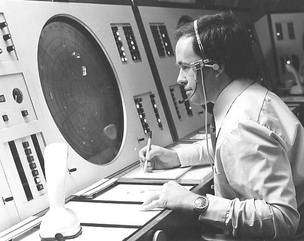
The bright display system presented raw radar returns overlaid by a video map showing airspace, routes and other important features. There was no labelling of returns, however SSR returns were displayed with a geometric symbol (e.g. rectangle, triangle) depending on the code being squawked. Target identification was done mostly by distance reports or observing a directed turn. Ident was maintained using 'shrimp boats' - pieces of perspex with the target's callsign written on them in chinagraph pencil, moistened and stuck on the screen by surface tension. The shrimp boats had to be manually moved along as the target moved. Two shrimp boats can be seen on the display in this photograph, as can a number of the 'slash' marks indicating a primary radar return.
Dick, did you look at any of the links provided? Did you read any of the posts?
Do you remember how primitive the ATC radar really was circa 1980? Are you really suggesting that wherever radar coverage existed the aircraft should have been under positive control, as that would have been the only option in those days? It was CTA or not, no "sort of". That's why we had CTA steps. Can you imagine how this system would have coped with multitudes of light aircraft going where ever they pleased? How many "shrimp boats" would be stuck on that screen, being physically kept track of and moved around by the operator? It was designed as a tool to manage aircraft on fixed routes in fixed airspace doing predictable things. You were cranky enough back then when ATC wouldn't let you go where you wanted in your chopper. Imagine if every where you wanted to go was controlled?
why couldn't BASI recommend such a change in the accident report!
Thread Starter
No. Not positive radar control. Just be in the same frequency as the person looking at the radar
Just a system like I introduced before taaats was finalised .
The aircraft was on a full position flight plan. If the pilot was communicating to a person with a radar screen there's a good chance the controller would have queried why the pilot was flying towards mountains almost right angles to the correct track. Surely not rocket science. Happened everywhere else in the 80s
And whether there are lines on a chart make absolutely no difference to procedures. You only want it as that's how they do it in the US, so you can crow.
How does having lines on a map detract from safety? How does not having them improve safety?
How does having lines on a map detract from safety? How does not having them improve safety?
The reversal by placing the frequency boundaries back on charts resulted in the present stuff up where CASA has a totally different view than the Rapacs.
You have no logical argument, Dick. Get over it.
continue the reforms so we are closely copying another proven safe system.
As an aside, how much were all the Americans paid, including travel allowances, to tell us how safe their system was?
Re #53......
Which two.....???
Freq AND location (s)...please....
Just for the' general info' as I was not in NSW Region at the time.....

Which two.....???
Freq AND location (s)...please....
Just for the' general info' as I was not in NSW Region at the time.....
Join Date: Aug 2007
Location: Melbourne
Age: 72
Posts: 774
Likes: 0
Received 0 Likes
on
0 Posts
Dick, you started this thread asking for a bit of history about FS and ATC, PREIA and CAOOAA. It has now drifted to one of your favourites, MDX and death by pressonitis. The forecast was crap and not suitable for night VMC. The aircraft wasn't approved for icing conditions. The pilot could have landed at Ballina, Coffs Harbour or Taree but chose to press on and not say anything until it was too late. What do you hope to gain that hasn't been gone over before?
Thread Starter
What I hope to gain is simple.
To point out to lots of intelligent readers of this site how change was resisted in the past and that's happening now so we can't move Foward to a safer simpler system.
No one ever commented at the time of the MDX crash that the pilot never actually spoke to a radar operator who could have quickly informed him of his incorrect navigation .
It's only different today because I pushed for the change - ie today a pilot
can communicate directly with the radar operator. That safety improvement was resisted in every way but I was able to say " just do it"
And Fuji. Yes the pilot made a number of errors. That's one of the reasons we have radar - to help pick up errors. In that case the radar was not used effectively.
I bet you would not support reversing my reforms and going back to two tier ATC and FS system.
Those reforms were resisted by many pilots at the time and as pointed out BASI didn't even make a recommendation that the available radar coverage be used to help stop a repeat of this type of accident
and as pointed out BASI didn't even make a recommendation
No. Not positive radar control. Just be in the same frequency as the person looking at the radar
Dick, youve changed the system, there's no one else to talk to but ATC, and people still fly into hills. You can't legislate against stupidity, bad luck, mechanical failure, or just plain pilot error, and you will never have a system that protects 100% against them. Nowhere else in the world has one either, no matter how much you insist on it.
Thread Starter
I have never claimed the overseas system has a safety figure of 100%.
I forced in the change so that all pilots could communicate directly to a radar controller for obvious reasons .
That was resisted by many. Some older airline pilots still believe they don't need radar and ATC to help prevent accidents.
The frequency boundaries were put back on the charts without any pilot education on how this half wound back system would work.
Fortunately there are lots of new pilots entering the system. Some of whom have flown overseas. They understand the need to follow the proven safe system as used overseas.
There are those who follow this site who now understand that frequency boundaries on charts are a throwback to the old FS days that no longer exist .
All modern GPS units show nearest ARTc outlet for those who want to get maximum coverage by ATC. The boundaries are a throwback to the 50s where HF was required in most places at low levels.
I am delighted with these discussions. The latest RAPAC paper even queries the need for frequency boundaries on charts. We are clearly getting somewhere
Join Date: Sep 2004
Location: inner suburbia
Posts: 370
Likes: 0
Received 0 Likes
on
0 Posts
How many times do people need to tell you that "... the proven safe system as used overseas" requires a mind-boggling amount of $$$ and time to completely change our ATC system.
For a start, the USA have in the region of 14000 front-line ATC staff, ASA has around 1000.
The USA has near total radar surveillance to low levels, Oz mostly has radar in the J curve.
where's that image of a broken-record
For a start, the USA have in the region of 14000 front-line ATC staff, ASA has around 1000.
The USA has near total radar surveillance to low levels, Oz mostly has radar in the J curve.
where's that image of a broken-record
The boundaries are a throwback to the 50s where HF was required in most places at low levels
Now that Area freqency is also an ATC frequency, and the rules still require calls on lhe local area frequency, I guess they reasoned people still had to know what and where it was. It is once you start throwing in ill-defined or poorly understood options that confusion occurs.
Thread Starter
Yes. That's because it has been half wound back
When the FS system was in place it was before my group introduced CTAFs based on the US system. Before AMATS local aerodromes were on the FS area or AFIZ frequency so the system worked.
That's why a few at CASA are trying to get circuit traffic on the area frequency. It's what we used to do . Can't you see that!
Thread Starter
Biggies. 50% of US instrument approaches have the IAF below radar coverage .
There are lots of hills and valleys in the USA and radar is line of site.
There are lots of hills and valleys in the USA and radar is line of site.
There are those who follow this site who now understand that frequency boundaries on charts are a throwback to the old FS days that no longer exist .
The boundaries are those of Flight Information Areas (FIA).
AIP:
Flight Information Area (FIA): An airspace of defined dimensions, excluding controlled airspace, within which flight information and SAR alerting services are provided by an ATS unit.
Flight Information: Information useful for the safe and efficient conduct of flight, including information on air traffic, meteorological conditions, aerodrome conditions and airways facilities.
This was the reasoning behind the RAPACs requesting Airservices return the boundaries to the charts many (14?) years ago.