


Remains of WW2 crew 'stored by collector'


Maybe more appropriate to a Dentists' Rumour Network, but a curious line in this report: -
What does this reference? Fillings to avoid barodontalgia perhaps - how could one tell this was pre-emtive work, rather than reactive?
And pre-emptive dental work performed by the RAF on servicemen flying at high altitude was noted in teeth.
Yes, pretty common. Also common for dentists in the UK in the 1950's to fill healthy molars that had deeper than average fissures on the top, but no sign of decay. All mine were done as a small child, causing significant damage when some molars have split later in life and have needed crowns fitting.
There’s mention of him doing other digs , without permission , on the Yorkshire Aircraft site.
I hadn’t seen the site before its’ mention here , so I’ve been reading some of it...
I assume he came upon these remains at the crash site because the original recovery missed them but , why remove them from there & having done that , why leave them on the surface & out in the open?
I hadn’t seen the site before its’ mention here , so I’ve been reading some of it...
I assume he came upon these remains at the crash site because the original recovery missed them but , why remove them from there & having done that , why leave them on the surface & out in the open?
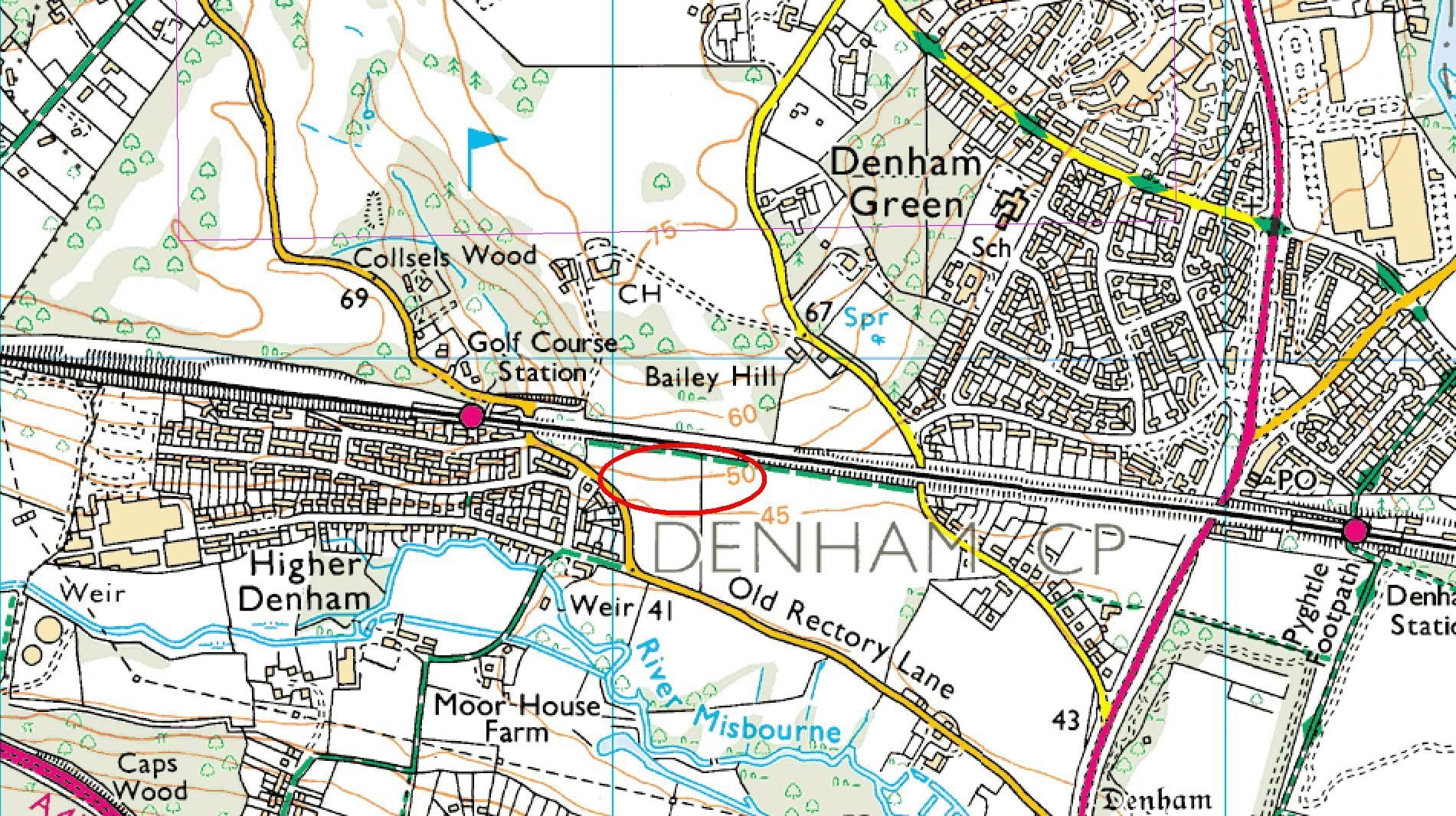
For those with an interest in old aviation crash sites, I've just tried to find the location of the place where we played as kids and found bits of wreckage. This is based on my memory from over 60 years ago, so is at best sketchy, and we moved away from Higher Denham out to Gerrards Cross in 1961, and I've never been back there since. I am absolutely certain that it was south of the railway line, and north of Old Rectory Lane, as we didn't go under the tunnel under the railway line to get there.
No idea at all if the area was ever properly excavated, but I do remember that there were bomb craters all around. We lived on Lower Road, Higher Denham, at the time, with the Martin Baker factory at the very end of that road (it's visible to the left of this OS map clip, just above the word "weir"), which may well have been a wartime target, perhaps? I have a feeling that it may have been an aircraft factory during the war, but had switched to making ejection seats when we lived there. I clearly remember the loud bangs from them testing them on a vertical crane-like structure they had down there.
Perhaps might be better if I posted in this in the history area, maybe the mods can best decide on that. The red ellipse is roughly where I think the crash site was:
Yes, pretty common. Also common for dentists in the UK in the 1950's to fill healthy molars that had deeper than average fissures on the top, but no sign of decay. All mine were done as a small child, causing significant damage when some molars have split later in life and have needed crowns fitting.
For those with an interest in old aviation crash sites, I've just tried to find the location of the place where we played as kids and found bits of wreckage. This is based on my memory from over 60 years ago, so is at best sketchy, and we moved away from Higher Denham out to Gerrards Cross in 1961, and I've never been back there since. I am absolutely certain that it was south of the railway line, and north of Old Rectory Lane, as we didn't go under the tunnel under the railway line to get there.
No idea at all if the area was ever properly excavated, but I do remember that there were bomb craters all around. We lived on Lower Road, Higher Denham, at the time, with the Martin Baker factory at the very end of that road (it's visible to the left of this OS map clip, just above the word "weir"), which may well have been a wartime target, perhaps? I have a feeling that it may have been an aircraft factory during the war, but had switched to making ejection seats when we lived there. I clearly remember the loud bangs from them testing them on a vertical crane-like structure they had down there.
Perhaps might be better if I posted in this in the history area, maybe the mods can best decide on that. The red ellipse is roughly where I think the crash site was:
No idea at all if the area was ever properly excavated, but I do remember that there were bomb craters all around. We lived on Lower Road, Higher Denham, at the time, with the Martin Baker factory at the very end of that road (it's visible to the left of this OS map clip, just above the word "weir"), which may well have been a wartime target, perhaps? I have a feeling that it may have been an aircraft factory during the war, but had switched to making ejection seats when we lived there. I clearly remember the loud bangs from them testing them on a vertical crane-like structure they had down there.
Perhaps might be better if I posted in this in the history area, maybe the mods can best decide on that. The red ellipse is roughly where I think the crash site was:
It might be worth an interested party finding out who the landowner is and getting permission for a field walk or metal detector search.
https://en.m.wikipedia.org/wiki/Aerial_archaeology
Disclaimer, I am not an archaeologist.
When I first went to a dentist in Canada in 1971, he looked in my mouth and laughed: "You've just come from England haven't you? I can tell by the terrible dentistry."
A look on Google Maps "satellite view" shows a disturbance in the crops (they are a lot more brown, with gaps than the rest of the field) almost smack in the middle of your location. It could be a natural phenomena, but equally such things are associated with buried remains of structures or, in this case, potentially a wreck.
It might be worth an interested party finding out who the landowner is and getting permission for a field walk or metal detector search.
https://en.m.wikipedia.org/wiki/Aerial_archaeology
Disclaimer, I am not an archaeologist.
It might be worth an interested party finding out who the landowner is and getting permission for a field walk or metal detector search.
https://en.m.wikipedia.org/wiki/Aerial_archaeology
Disclaimer, I am not an archaeologist.
Thanks, there was a lot of bit sof metal there at the time, mostly aluminium, plus some larger corroded lumps of steel. It was my friend, Peter, that found the ammunition belts, partly buried in a large patch of nettles. As already mentioned, there were bomb craters around the area, some with water in the bottom. Our parents had told us to not go near there, but of course, being 7 or 8 years old we just ignored them. I clearly remember riding our bikes up Old Rectory Lane and leaving them at the side of the lane, just before the tunnel under the railway, before we went exploring. At a guess this would have been around 1959 or thereabouts. Whatever had crashed there must have been quite large, as I remember there were bits of metal covering a wide area (or it seemed a wide area to us as kids).
I've always suspected that it was most probably a German bomber that crashed there, perhaps en route to the Martin Baker factory a short distance away, but that's pure supposition, as I have no idea of the calibre of the rounds we recovered from there, other than they seemed (compared to the size of our hands) to be very large. My dad had a .22 rifle and I had a .177 Diana airgun, so I would have had a rough idea of the calibre. I know the rounds were a lot longer than the width of my hand, and that we could only get around half a dozen of them into the pockets of our shorts, so somewhere around .50 at a guess. Thinking back it seems pretty shocking that we took these rounds into school (Denham County Primary School) to show them off to our mates.
