


Teaching navigation

Thread Starter
Teaching navigation
We still seem to be teaching nav as it was taught a lifetime ago; map, compass and watch. But the world has changed, controlled airspace is all over the country and the consequences of infringing are serious. As it is, the student will do her PPL nav with map and preprepared plog, gain a licence, then just fly around using skydemon. If skydemon becomes unavailable, have we adequatly trained her for that significant problem?
Would it not be better to teach all cross countries with skydemon, whilst maintaining a plog and following progress on a chart? On most training legs, the moving map could be taken away, such that loss of GPS and reversion to map reading would be a routine thing? It could then be hoped that this practice of running paper backup alongside skydemon would continue after graduation. But as it is, she may discard the map and plog in favour of total reliance on skydemon, with no training on reversion to paper.
Would it not be better to teach all cross countries with skydemon, whilst maintaining a plog and following progress on a chart? On most training legs, the moving map could be taken away, such that loss of GPS and reversion to map reading would be a routine thing? It could then be hoped that this practice of running paper backup alongside skydemon would continue after graduation. But as it is, she may discard the map and plog in favour of total reliance on skydemon, with no training on reversion to paper.

On most training legs, the moving map could be taken away, such that loss of GPS and reversion to map reading would be a routine thing?
teaching nav as it was taught a lifetime ago; map, compass and watch.
But as it is, she may discard the map and plog in favour of total reliance on skydemon, with no training on reversion to paper.
The process of navigation is the same today as it was centuries ago. The equipment we now have does it for us, meaning the operator is no longer capable of doing it without the equipment. The question is do we train the operator to do it conventionally or do we train the operator to cope with equipment failure. 50 years ago on the V-Force we called that Limited Procedures (LPs) and we practiced it all the time.
Last edited by Whopity; 2nd Mar 2024 at 23:05.
The problem is we don't train new pilots on how to correctly use the new technology, its just banned from the cockpit and then the new PPL figures it out for themselves. What is needed is an introduction to based navigation principals and then how they can be used to provide a sanity check to the electronic magic and how to gracefully recover when the screen suddenly goes blank.
It is important to realize that the traditional methods of navigation were used because in the old days there was no way to have updated positions and rate of change of positions in real time. GPS obviates this challenge and provides much increased precision and accuracy for pilot navigation. It is IMO stupid to deliberately use a less accurate method of navigation. But and this is a big but, it is also easy to to miss use it so understanding what it is telling you is a skill that can and should be taught. to new pilots.
It is important to realize that the traditional methods of navigation were used because in the old days there was no way to have updated positions and rate of change of positions in real time. GPS obviates this challenge and provides much increased precision and accuracy for pilot navigation. It is IMO stupid to deliberately use a less accurate method of navigation. But and this is a big but, it is also easy to to miss use it so understanding what it is telling you is a skill that can and should be taught. to new pilots.
I have never used, or even seen, SkyDemon but I learned to use various VFR and IFR GPS based navigation systems without needing any instruction.
A potential killer is that VFR pilots become very familiar with DIR TO navigation and may try to use it in IMC without knowing what terrain or obstructions are on that DIR TO route. It must be empaphasized that the convenience of DIR TO navigation is not a substitute for proper flight planning.
I would suggest that in most cases if it is not tested it is not taught.
The fundamental problem is that there is no standard trainer with standard equipment, the military can teach all their pilots the same but the GA World has to make do with a huge range of different equipment some installed and some handheld and of course there is no requirement to have any specific equipment at all.
To produce a syllabus to cater for so many variables is difficult if not impossible. Changing a syllabus is not a panacea either as most instructors teach what they were taught to teach and it might take a generation to make an effective change.
The UK CAA introduced a new PPL Syllabus in 2015 in CAP1298; how many have actually seen it or use it and is it any different to what has gone before?
The only common point is traditional Nav which remains in the syllabus. Teaching all the other variables that now exist means it can't realistically be done in the time normally allocated.
There are fundamental principles that apply to the use of every GPS system and associated moving maps, like
1) Check that the database is up to date
2) What data blocks do you want
3) Understand the difference between bearing, track, and direct track
4) When to use ETE vs ETA
5) How you can use ground speed to manage flight profiles
6) What map scales are appropriate for each phase of flight
7) Advantages and disadvantages of the direct to function
8) Lateral vs vertical navigation
9) Managing navigator induced cockpit distraction and strategies to ensure that a good lookout is maintained
10) Strategies to recover from a sudden navigator failure.
11) Strategies to use the navigator to most efficiently and safely fly an unplanned inflight diversion.
I would suggest that if you asked the average PPL instructor the above questions they would really struggle to provide sensible answers.
There is no difference in navigation between dead reckoning: distance/time and heading balancing drift. whether operating with a GPS or not the principles remain the same: the earths form remains the same. When you are taught dead reckoning you are taught navigation whether using GPS later or not. The only real difference is that the GPS provides instantaneous off track errors, position plus continuous ETA revisions. The GPS also offers a neat moving map. GPS screen graphics offer a much easier and more practical medium than a large and very cumbersome folded paper map; to read requires technique.
By learning traditional heading and time and map fixes to reassess errors you are operating as your GPS software works and receiving a trained fall back following a GPS failure which are not uncommon. Remember also; rubbish in = rubbish out, so you need comprehensive navigation training to properly understand this.
By learning traditional heading and time and map fixes to reassess errors you are operating as your GPS software works and receiving a trained fall back following a GPS failure which are not uncommon. Remember also; rubbish in = rubbish out, so you need comprehensive navigation training to properly understand this.
Last edited by Fl1ingfrog; 3rd Mar 2024 at 19:55.
There is no difference in navigation between dead reckoning: distance/time and heading balancing drift. whether operating with a GPS or not the principles remain the same: the earths form remains the same. When you are taught dead reckoning you are taught navigation whether using GPS later or not. The only real difference is that the GPS provides instantaneous off track errors, position plus continuous ETA revisions. The GPS also offers a neat moving map. GPS screen graphics offer a much easier and more practical medium than a large and very cumbersome folded paper map; to read requires technique.
By learning traditional heading and time and map fixes to reassess errors you are operating as your GPS software works and receiving a trained fall back following a GPS failure which are not uncommon. Remember also; rubbish in = rubbish out, so you need comprehensive navigation training to properly understand this.
By learning traditional heading and time and map fixes to reassess errors you are operating as your GPS software works and receiving a trained fall back following a GPS failure which are not uncommon. Remember also; rubbish in = rubbish out, so you need comprehensive navigation training to properly understand this.
The trouble is almost nobody teaches a wholistic approach to using GPS navigators and the associated moving maps. I once was asked to fly with a new pilot to an airport that was well known for having an excellent restaurant and he would buy me lunch. On the way back there is a bunch of fast button pushes on the Garmin 430 and the pilot announces he is ready. I ask what the track and distance to home is. He says 039 for 126 miles, so I ask what the track and distance was to get here, UMMM 331 and 79 miles..........OHH.
Everybody I know uses Foreflight. It is very easy to check the update status.
Join Date: Nov 2000
Location: White Waltham, Prestwick & Calgary
Age: 72
Posts: 4,153
Likes: 0
Received 29 Likes
on
14 Posts
A slide rule is an aid to someone who knows what they are doing - I would suggest that automation occupies the same position. Therefore the basics should be taught, and properly, if for no other reason as a mark of respect to the people who learnt the hard way that the basics are necessary. At least that's what I teach my students. But then, to me the A/H is a backup, not a primary instrument.
Personally I think that compass and paper map should be taught and mastered first, and be the habitual reference.
The danger is that new pilots naturally want to use GPS gizmos in their cockpits - because they are much easier, and involve no maths - so they jump straight to those before properly learning compass and map.
Compass direction is vital for ones's situational awareness - for dead reckoning or lining up on the correct runway, or flying a raw data ILS, or tracking an NDB.
Use of a paper map is important for identifying prohibited airspace, military areas or high ground that a GPS device might ignore if you get airborne and then input a direct-to command.
We can all think of garbage in garbage out situations that we ourselves have created or experienced with our car satnavs or aircraft FMS. A solid grounding in compass and paper map is important for situational awareness and gross error checking.
If all else suddenly fails; e.g. an electrical power failure; pilots need to be able to drop straight onto Heading, V/S and Altitude to get them home. this needs to be instinctive rather than them having to try to work out how to read and use a compass during a major power failure whilst airborne.
Left to my own devices, and not constrained by school standardisation and the test syllabus, I'd teach integrated PLOG and GPS, then do diversions "no screen". In practice I have to do it the other way around somewhat - screen only for traffic and airspace, not navigation most of the time, and bizarely students CAN use VOR on a diversion but not normal nav. Standards are slipping, very badly, and I suspect were poor in the first place - the present odd approaches to teaching aren't helping at-all.
In the last few months I've had a 45hr student move from another school, who had no personal culture of keeping data on a kneeboard. I've had another who passed his PPL within the last 3 years, doing his NQ with me, unable to find his way to our base airfield at night when I went "no screen" (I set up that situation with a very visible motorway going all the way from A to B, and he still couldn't handle it). At the same time whether it's SD, a GNS, or some other tool, far too many pilots - student or already qualified, just won't actually put the effort into learning the device they're flying with. That's no better or worse than using DR nav and not learning the tools of that properly.
I have become a big fan of SkyDemon (and yes, you can check the database is up to date), I just don't rely on it absolutely, nor will I let my students. Very happy to see a route on SD, I just want to see it on a chart and PLOG too, and if the device fails, I expect my students to be able to complete the trip, or make a safe diversion. Maybe a bit less elegantly, but still complete it.
G
I have been thinking about how to put my perspective on this into words, but Genghis has already done this for me! Thanks!
The problem is that I haven't taught this particular lesson for a few years and the industry has moved more towards the equivalent of an EFB in every Cessna within these years. Before that, I saw students who were unable to figure out which way is north using a map, who were easily confused when presented with a couple of motorways to follow and every combination of this. Fortunately, most of them were able to acquire the needed skills in due course, but I really wonder how many are still able to use them today. For day-to-day operations in good weather, no problem, but what happens on those days when you need your plan B...
The problem is that I haven't taught this particular lesson for a few years and the industry has moved more towards the equivalent of an EFB in every Cessna within these years. Before that, I saw students who were unable to figure out which way is north using a map, who were easily confused when presented with a couple of motorways to follow and every combination of this. Fortunately, most of them were able to acquire the needed skills in due course, but I really wonder how many are still able to use them today. For day-to-day operations in good weather, no problem, but what happens on those days when you need your plan B...
Regarding garbage-in garbage-out with GPS navigation systems; I don't know quite how I managed to programme this, (green line); but I was quite proud of myself !!! 
(that's why it is important to check and double check, as I was doing here - it must have been an early start !).
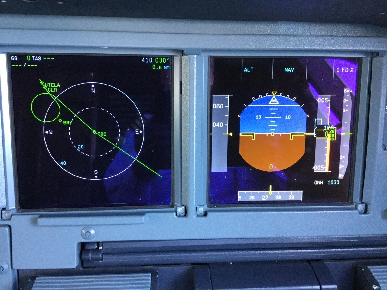
(that's why it is important to check and double check, as I was doing here - it must have been an early start !).
Most, if not all, GPS based navigation systems can be configured to display ground speed and track and these parameters are very useful even if no destination or route has been entered.
This took only a few seconds to find, https://www.skydemon.aero/plan/versionhistory.aspx