


Postwar aircraft ID

Thread Starter
Join Date: Dec 2020
Location: Orkney
Posts: 28
Likes: 0
Received 0 Likes
on
0 Posts
Postwar aircraft ID
Please could I be indulged once again with a mysterious photograph (hopefully attached and displayed here)
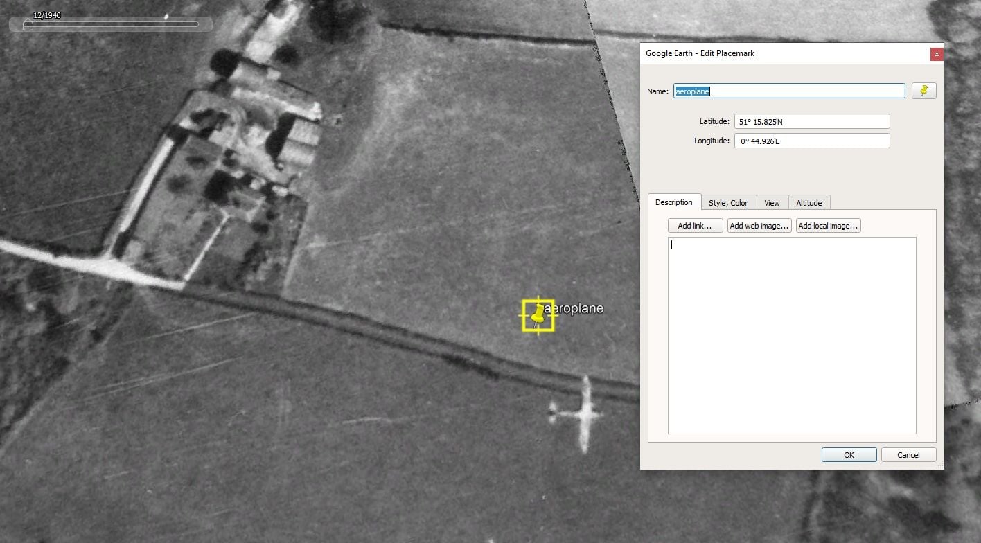
I was using GoogleEarth's historical imagery facility to do a bit of research of a favourite area in Kent, when I noticed that one of the aerial photographs had captured an aircraft (presumably in flight) below the camera. Google Earth shows the date of the images as a rather suspiciously start-of-decade 1/1/1940. I am pretty sure that the true date of this series of mosaiced photographs is after the end of hostilities.
Could the assimilated brainpower of those on the forum please assist with a most likely aircraft identification for this one in the screenshot please?
exact location of this is
51� 15.825'N
0� 44.926'E
ie, parish of Wichling, between the villages of Doddington and Lenham in Kent.
mystery aircraft appearing in aerosurvey googleearth near Doddington

I think it is a DeH 89 Rapide/Dominie.Twin engined long tapered biplane wings,which from a non-vertical picture ,can appear to be `longer`...
Pity there`s no shadow ...
You could try it in` AV HISTORY `thread
Pity there`s no shadow ...
You could try it in` AV HISTORY `thread
Thread Starter
Join Date: Dec 2020
Location: Orkney
Posts: 28
Likes: 0
Received 0 Likes
on
0 Posts
funny coincidence but I metal-detected this up 700m away from that position.
Dont think a DH Rapide ever mounted a cannon though :-> Had a look at the ID photos of a Rapide and I strongly agree. the wing plan is so narrow I guess that it has to be a biplane to achieve required lift. Not that I know ANYthing about aircraft above the level of pub chat.
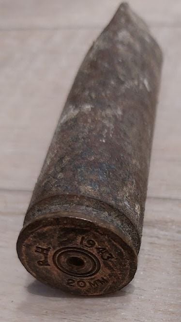
Dont think a DH Rapide ever mounted a cannon though :-> Had a look at the ID photos of a Rapide and I strongly agree. the wing plan is so narrow I guess that it has to be a biplane to achieve required lift. Not that I know ANYthing about aircraft above the level of pub chat.
Funnily enough, I was looking at the same dataset earlier today, and concluded that the imagery was either prewar or very early during the war, at least for the areas i was interested in; the WW2 airfields I was hoping to look at still appear as fields.
Agree with Sycamore, definitely a DH Dominie. Twin engined biplane with slim wings and characteristic DH tailplane. Relative size of wing roundels and silver colouring rule out any fighter/bomber.
Gnome de PPRuNe
Join Date: Jan 2002
Location: Too close to Croydon for comfort
Age: 60
Posts: 12,664
Received 321 Likes
on
178 Posts

Join Date: Oct 2016
Location: Christchurch
Posts: 74
Likes: 0
Received 0 Likes
on
0 Posts
Totally agree with those suggesting DH 89 Rapide/Dominie, and nothing like a Whirlwind in my opinion. The slight sweep-back of wings and their general slimness plus general proportions, including somewhat fuller fuselage than Whirlwind clinches it for me.
There are a lot of photos in that "1940" mosaic. Who's going to find the next airborne aircraft? 
I had previously looked at Manston in this mosaic and there are some interesting aircraft on the ground:
Wellingtons ( 51�20'51.35"N, 1�19'34.60"E ) and Mosquitos (?) ( 51�20'56.87"N, 1�19'32.33"E ) on The Loop dispersal, a Manchester ( 51�20'35.11"N, 1�19'52.11"E ) on the west end of the runway and two Spitfires (?) in revetments and nine larger SE types, conveniently arranged for a strafing run (51�20'49.51"N, 1�20'40.78"E ).
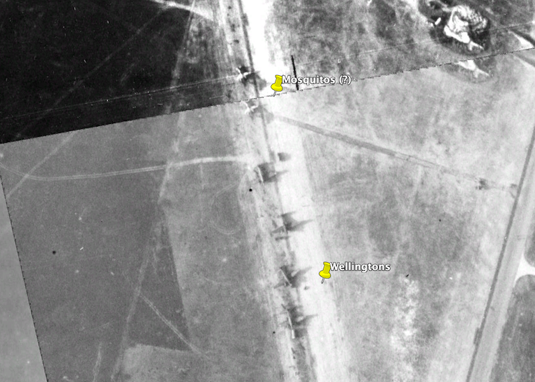
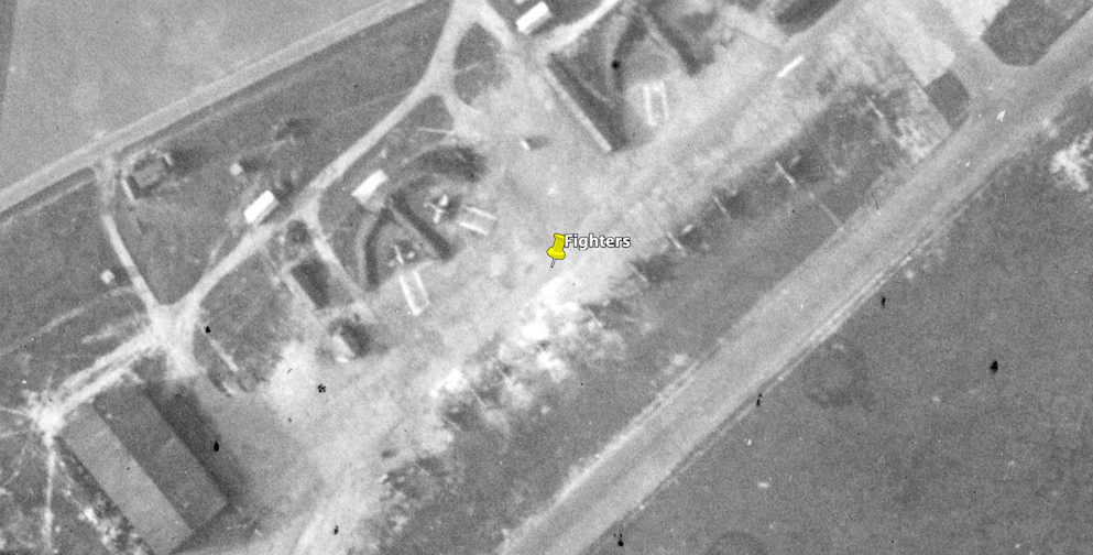
Last edited by India Four Two; 11th Jan 2023 at 03:15. Reason: Typo
Thread Starter
Join Date: Dec 2020
Location: Orkney
Posts: 28
Likes: 0
Received 0 Likes
on
0 Posts
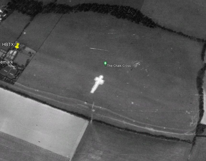
the nearby Chalk cross at Lenham village ( 51� 14.513'N 0� 43.734'E) is clearly un-covered in the dataset, and I understand that it was covered up for all of the war to stop its use as a landmark.
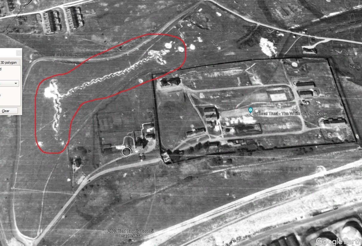
and on looking around Dover I see what appears to be trenches which were probably dug after hostilities commenced, but I guess neither of these are really conclusive.
These are some places where the oldest GE imagery is completely missing an airfield. Brize Norton is a good example, whereby just fields are shown, whereas Broadwell, just a few miles to the west, is clearly visible. Other airfields that are "missing" are Hullavington and Keevil. I wonder whether some airfields have been purposely omitted and an artificial overlay of fields inserted instead?
These are some places where the oldest GE imagery is completely missing an airfield. Brize Norton is a good example, whereby just fields are shown, whereas Broadwell, just a few miles to the west, is clearly visible. Other airfields that are "missing" are Hullavington and Keevil. I wonder whether some airfields have been purposely omitted and an artificial overlay of fields inserted instead?
I found this article with an WW2 aerial photograph of Staverton (which opened in 1931), clearly showing attempts to camouflage the airfield, but that camouflage doesn't correspond to the Google Earth imagery. However Google Earth does show some nearby buildings which I suspect were associated with the airfield. I've also just noticed that the Google Earth imagery shows a higher level of contrast over the area of the airfield itself; I suspect you're right, and that the images have been doctored.
Upper Heyford (1918) is completely missing, but without the increased contrast. Bicester (1916) looks as though the airfield is visible, possibly including actual camouflage features. I can't see any hangars, which there would have been by 1940; they may have been removed from the imagery, or just lost on the join between 2 images.
Edit: And this snippet from the Wikipedia page for Croughton (which appears very clearly in the imagery):
In September 1940 the Air Ministry decided that certain stations would be designated as emergency airfields. These stations would give assistance to any operational aircraft returning damaged or with engine problems. The Station Commander at RAF Upper Heyford received one of these orders. RAF Brackley (Croughton) would remain open with its flare paths illuminated irrespective of enemy activity in the area. This meant that RAF Brackley along with other emergency airfields attracted additional enemy night attacks. Added to this accepted high risk was the fact that RAF Brackley was a training airfield.
Thread Starter
Join Date: Dec 2020
Location: Orkney
Posts: 28
Likes: 0
Received 0 Likes
on
0 Posts
a thought occurred to me that the most statistically likely "incident" resulting in 20mm spent ammo falling over this part of Kent might have been interception of a doodlebug V1/V2 rocket.
or gun testing (?) Detling airfield probably the closest and therefore most likely base...
were there any other significant air campaigns over Kent after the Battle of Britain?
did the empty cartridges simply fall out of the aircraft?
did the empty cartridges simply fall out of the aircraft?
I've often wondered if anyone ever got hurt by these during the BoB.
a thought occurred to me that the most statistically likely "incident" resulting in 20mm spent ammo falling over this part of Kent might have been interception of a doodlebug V1/V2 rocket.
or gun testing (?) Detling airfield probably the closest and therefore most likely base...
were there any other significant air campaigns over Kent after the Battle of Britain?
did the empty cartridges simply fall out of the aircraft?
or gun testing (?) Detling airfield probably the closest and therefore most likely base...
were there any other significant air campaigns over Kent after the Battle of Britain?
did the empty cartridges simply fall out of the aircraft?
At some time, AA fire was only used inland and offshore firing at V1s (you ain't even gonna see a V2) was limited to over the sea.
By the way to avoid confusion, where I said 'phased out by 1943' I was referring to the Whirlwind not the 20mm cannon shells. These cannon were installed in the Whirlwind from day 1 whereas the Hurricanes and Spitfires originally had .303 machine guns.
Last edited by chevvron; 15th Jan 2023 at 11:44.
