


Name this Cornwall airfield please — Perranporth?

Thread Starter
Join Date: Apr 2020
Location: Wellington
Posts: 7
Likes: 0
Received 0 Likes
on
0 Posts
Name this Cornwall airfield please — Perranporth?
Hello people.
I am trying to figure out which abandoned airfield I visited in Cornwall in December 1986. My brother and I were driving around Cornwall for a day and we tried to find an airfield which I remember as being Perranporth, but looking at it now I don't think it can have been. We were heading north and visited the town of Perranporth I think right after, so it was close, and I believe south of Perranporth town. The location of Perranporth airfield fits with this memory.
What I can recall is this. Going from a map we had driven coastward from a main road looking for it and discovered it only when we realised we were essentially on the runway! It was in very poor repair, with grass growing through the rough concrete, but clearly a runway. Looking on a contemporary map it seems like this cannot have been Perranporth unless it was subsequently massively overhauled, and I can find no mention of this online.
I can see a disused field between Portreath and Porthtowan, but looking at satellite imagery it seems in way too good a state of repair compared to what I remember. If I have the direction wrong, we did reach RAF St. Mawgan and I think that was the furthest north we got before returning to Plymouth.
This is all going from a 34 year old memory so I may well have key facts wrong, but would appreciate any info from anyone who's familiar with this area from that era.

Does this help?
https://www.perranporthairfield.com/contact.html
https://www.perranporthairfield.com/contact.html
Gnome de PPRuNe
Join Date: Jan 2002
Location: Too close to Croydon for comfort
Age: 60
Posts: 12,666
Received 327 Likes
on
180 Posts
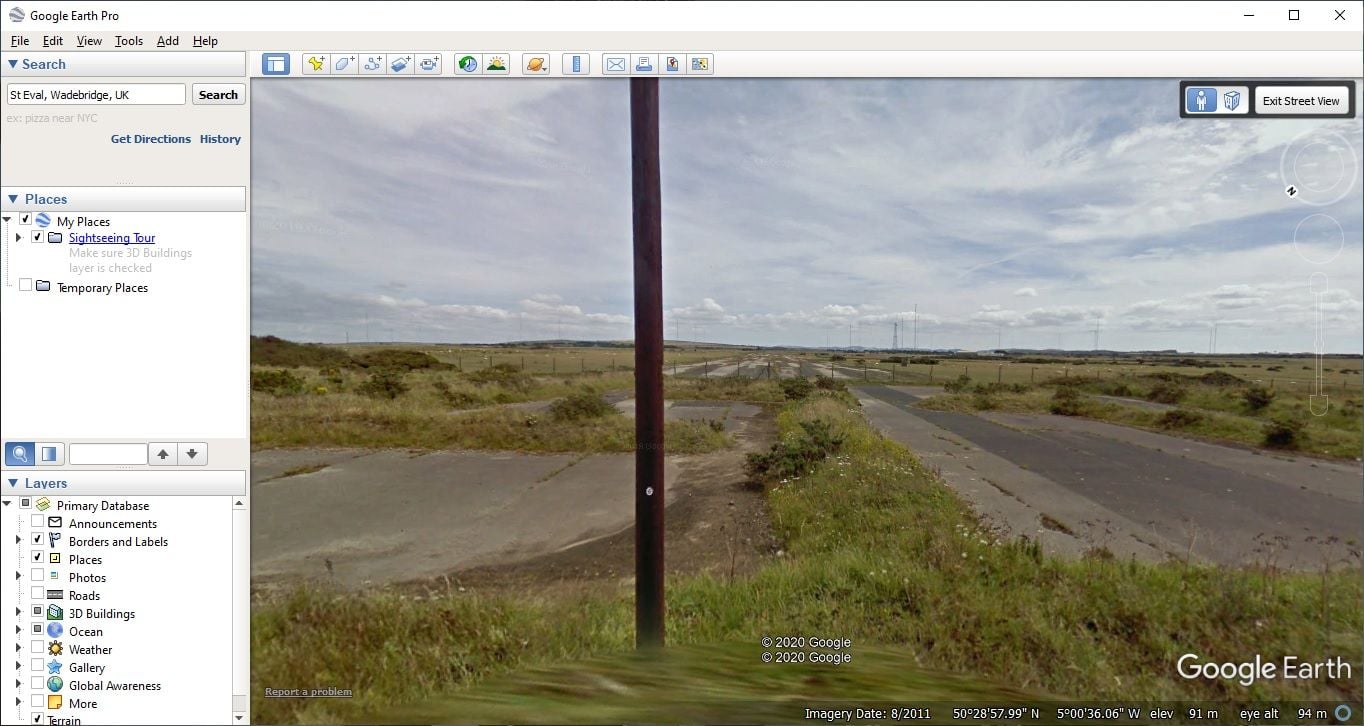
Sounds like St Eval, north east of Newquay and St Mawgan. I think there is a road along part of a runway...
Thread Starter
Join Date: Apr 2020
Location: Wellington
Posts: 7
Likes: 0
Received 0 Likes
on
0 Posts
One further clue is the road we found ourselves on was very sketchy and we intersected a runway.
St Eval is looking more likely based on location (we definitely circumnavigated St. Mawgan).
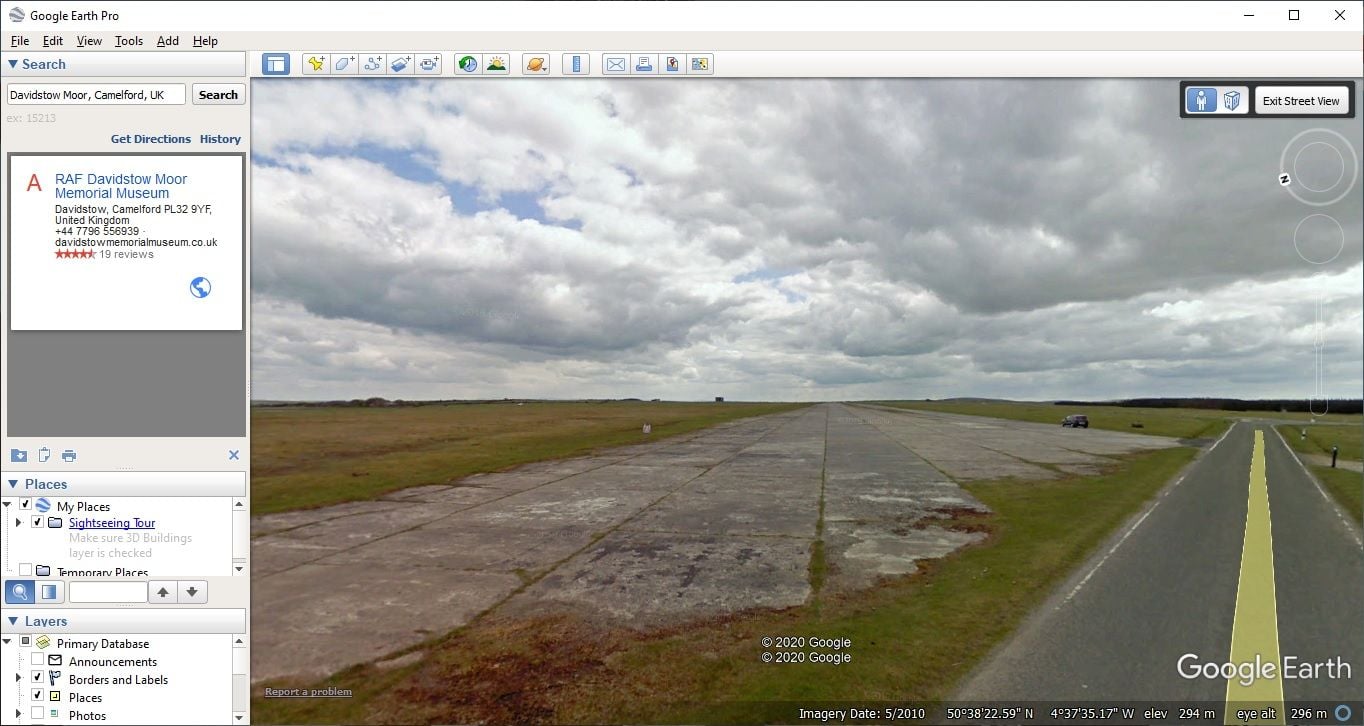
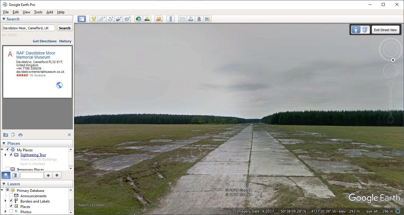
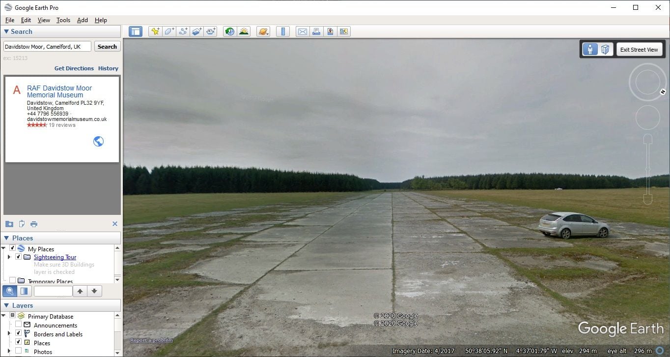
Davidstow does look more like the right "state of repair" from what I remember. It was so rough that we had to convince ourselves at first that it was indeed a runway, based on the breadth of (broken) concrete. We could only really see the extent of it once we were on it.
I'm not sure if we got that far north, though. I need to have a chat with my brother sometime to see if he remembers any more pertinent details.
St Eval is looking more likely based on location (we definitely circumnavigated St. Mawgan).
Davidstow does look more like the right "state of repair" from what I remember. It was so rough that we had to convince ourselves at first that it was indeed a runway, based on the breadth of (broken) concrete. We could only really see the extent of it once we were on it.
I'm not sure if we got that far north, though. I need to have a chat with my brother sometime to see if he remembers any more pertinent details.
Last edited by zkarj; 1st May 2020 at 04:47. Reason: Fixed bad editing

Avoid imitations
Join Date: Nov 2000
Location: Wandering the FIR and cyberspace often at highly unsociable times
Posts: 14,580
Received 436 Likes
on
230 Posts
The description makes it sound very much like Davidstow.
Join Date: May 2008
Location: Canterbury, New Zealand
Posts: 22
Likes: 0
Received 0 Likes
on
0 Posts
Name this airfield.
St. Eval at that time would have been easily recognisable due to the HF aerials mentioned by a previous poster, plus it had a large R.A.F. maried quarters patch and families facilities adjacent to the airfield. (I lived on the patch till 1980) .Some small commercial businesses may also have been operating around the perimeter by then. Good luck with your search.
Thread Starter
Join Date: Apr 2020
Location: Wellington
Posts: 7
Likes: 0
Received 0 Likes
on
0 Posts
Phileas Fogg that second picture of Davidstow looks the part. I do not recall anything prominent in the vicinity, just that we found the runway only when we were on it.
I'm still fighting my memory that it was near Perranporth, but other stuff I have researched from our trip has also proven my memory to be patchy.
Thanks everyone for weighing in. It seems the weight of evidence is indeed on Davidstow. And... I have just found a further corroboration we went that far up. I remember very clearly we saw a road sign for the wonderfully named town of Crapstone, which makes me suspect our route was A395, A30, A388, B3362, A386.
Join Date: Jul 2004
Location: Cloud 9
Posts: 2,948
Likes: 0
Received 0 Likes
on
0 Posts
Phileas Fogg that second picture of Davidstow looks the part. I do not recall anything prominent in the vicinity, just that we found the runway only when we were on it.
I'm still fighting my memory that it was near Perranporth, but other stuff I have researched from our trip has also proven my memory to be patchy.
Thanks everyone for weighing in. It seems the weight of evidence is indeed on Davidstow. And... I have just found a further corroboration we went that far up. I remember very clearly we saw a road sign for the wonderfully named town of Crapstone, which makes me suspect our route was A395, A30, A388, B3362, A386.
I'm still fighting my memory that it was near Perranporth, but other stuff I have researched from our trip has also proven my memory to be patchy.
Thanks everyone for weighing in. It seems the weight of evidence is indeed on Davidstow. And... I have just found a further corroboration we went that far up. I remember very clearly we saw a road sign for the wonderfully named town of Crapstone, which makes me suspect our route was A395, A30, A388, B3362, A386.
Sounds like Perranporth to me, as it was possible to drive on to the main runway off the very broken track that lead to Cligga Head. This was the end that housed the Gliding Club and also the location of a post war hangar. The ends of the runway were a bit tatty, but a couple of hundred yard on, the tarmac was very good and indeed was suitable for licensing in the 90's. There was no fence across the end of runway 23 as the Gliding Club at the time had to tow their machines onto the airfield via this location.
At some time a simple car tyres (wired together) structure used to be dragged across the runway end to prevent people driving onto the site, but frequently this was open if gliding was in operation. Years later a huge pair of gates were erected to secure the airfield as part of the licensing requirement.
Most people thought the Perranporth runways were bad because they only saw the very ends, but in fact 85% of the runways were fine as the airfield had a been 'serviced' in the 50's to allow commercial flying. The watch office (control tower) at the St Agnes end was reactivated in the 90's having been used as a cow shed for decades. Despite a huge battle with the local authority at the time who tried to impose restrictions of movements, a public enquiry threw this out,and the airfield is still active plus has a new hangar to protect the machines based there. TREADS if you are reading this you can post the image of the Spitfire replica (flying out of Perranporrth on test) complete with makings of a squadron based there in the war.
Last edited by POBJOY; 5th May 2020 at 10:10.
Gnome de PPRuNe
Join Date: Jan 2002
Location: Too close to Croydon for comfort
Age: 60
Posts: 12,666
Received 327 Likes
on
180 Posts
Here you go Pobjoy!
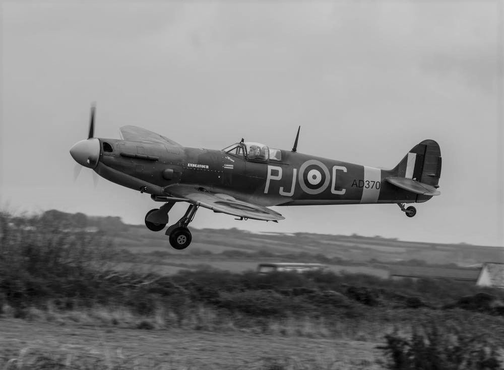
Jurca M10 replica Perranporth Spitfire flying from its original base on test. Built locally (all wood) 300 HP continental.
Flys as good as it looks, and the wheels go up and down.
Kenley next stop !!!! Well done TREADS.
Flys as good as it looks, and the wheels go up and down.
Kenley next stop !!!! Well done TREADS.
Thread Starter
Join Date: Apr 2020
Location: Wellington
Posts: 7
Likes: 0
Received 0 Likes
on
0 Posts
Sounds like Perranporth to me, as it was possible to drive on to the main runway off the very broken track that lead to Cligga Head. This was the end that housed the Gliding Club and also the location of a post war hangar. The ends of the runway were a bit tatty, but a couple of hundred yard on, the tarmac was very good and indeed was suitable for licensing in the 90's. There was no fence across the end of runway 23 as the Gliding Club at the time had to tow their machines onto the airfield via this location.
The only bit that doesn't fit is the general state of repair today (as per Apple and Google Maps) suggests it has been improved since we were there as the only bit that looks suitably in disrepair to match what I remember would be the threshold of 27.
Beginning to sound as though you may have taken the old Trebelzue gate access towards St Mawgan, which initially took you on to the old Trebelzue Airfield (which became St Mawgan when the new runway was built c1943). It was also the short cut to 'The Falcon' in St Mawgan village!
Beginning to sound as though you may have taken the old Trebelzue gate access towards St Mawgan, which initially took you on to the old Trebelzue Airfield (which became St Mawgan when the new runway was built c1943). It was also the short cut to 'The Falcon' in St Mawgan village!
YS🇺🇸☀️