


Sevenoaks pointer to Biggin

Thread Starter
Joined: Nov 2003
Posts: 42
Likes: 0
From: London
Sevenoaks pointer to Biggin
While I was doing my ATC flying scholarship during 1969 at Biggin Hill, I seem to remember in the vicinity of Sevenoaks there was a large painted arrow that indicated the direction back to the airfield.
It's a long time ago now and I can't find any trace of it on Google maps, so house building or the M25 might have erased it, but does anyone know just where it used to be?
It's a long time ago now and I can't find any trace of it on Google maps, so house building or the M25 might have erased it, but does anyone know just where it used to be?

Joined: Apr 2010
Posts: 285
Likes: 0
From: london
While I was doing my ATC flying scholarship during 1969 at Biggin Hill, I seem to remember in the vicinity of Sevenoaks there was a large painted arrow that indicated the direction back to the airfield.
It's a long time ago now and I can't find any trace of it on Google maps, so house building or the M25 might have erased it, but does anyone know just where it used to be?
It's a long time ago now and I can't find any trace of it on Google maps, so house building or the M25 might have erased it, but does anyone know just where it used to be?
Last edited by pasir; 30th August 2019 at 14:51. Reason: remembered a further relative addtion

Joined: Jul 2007
Posts: 188
Likes: 8
From: London
I have a very vague memory (wait, there's more....) of some sort of large white arrow, maybe cut into a chalk hillside, pointing towards Croydon Airport, probably in the 1920s, not that I was around then to need it.
Gnome de PPRuNe


Joined: Jan 2002
Aviation Qualifications: Spotter
Posts: 15,184
Likes: 1,200
From: Too close to Croydon for comfort
Buster, I've heard of that too.
I would have thought Biggin ought to be clearly visible from 1000' over Sevenoaks in reasonable vis.
I would have thought Biggin ought to be clearly visible from 1000' over Sevenoaks in reasonable vis.


Joined: Sep 2010
Aviation Qualifications: ATPL
Posts: 884
Likes: 233
From: by the seaside
Gasometer Bishops Waltham.
4 of us set out one evening to paint an arrow and HA on one of Hamble’s rejoining points.
A few days later with my instructor in the Baron..Pat Courtney (he who left a hurribomber wingtip on a tree stump somewhere out east)..asked why the arrow was pointing the wrong way?
Twas how I learnt that the top rotates with the change in volume in said structure.

Joined: Aug 2000
Posts: 120
Likes: 3
There is a large white arrow clearly visible on Google Earth just to the east of Skipness village (by the graveyard) at the top end of the Mull of Kintyre. I believe this is a hangover from WW11 and was something to do with a nearby weapons range. In addition, I think there is another one further south, not so easily seen.
Just found the second arrow. It’s just south of the village of Crossaig, in scrubby land east of the B842.
Just found the second arrow. It’s just south of the village of Crossaig, in scrubby land east of the B842.
Last edited by Audax; 20th September 2019 at 13:49.
Joined: Oct 2006
Posts: 70
Likes: 0
From: welwyn
There is a large white arrow clearly visible on Google Earth just to the east of Skipness village (by the graveyard) at the top end of the Mull of Kintyre. I believe this is a hangover from WW11 and was something to do with a nearby weapons range. In addition, I think there is another one further south, not so easily seen.
Just found the second arrow. It�s just south of the village of Crossaig, in scrubby land east of the B842.
Just found the second arrow. It�s just south of the village of Crossaig, in scrubby land east of the B842.
Joined: Oct 2002
Aviation Qualifications: PPL
Posts: 8,201
Likes: 347
From: London UK
In the 1920s, to aid the Croydon to Paris air service, the railway stations on the Sevenoaks to Dover line apparently had their name painted in large letters on the roof tiles of the station buildings, readily visible from the height then flown at. Presumably removed by 1939.
Joined: Dec 2007
Posts: 529
Likes: 6
From: Hertfordshire
In the 1920s, to aid the Croydon to Paris air service, the railway stations on the Sevenoaks to Dover line apparently had their name painted in large letters on the roof tiles of the station buildings, readily visible from the height then flown at. Presumably removed by 1939.

Joined: Feb 2006
Posts: 1,466
Likes: 188
From: 11 GROUP
Airfield names
Long after Croydon closed (1959) the rotating beam was kept going for a considerable time.
Also Banstead railway staion (to the west ) had its name boldly emblazoned for many years and apparently was a reporting point in the early radio days.
I have seen large white crosses marked in unusual places but some of them were 'range indicators' to ensure correct direction of aircraf for firing/dropping.
In the case of a marker for BH then Croydon would be in the same direction or very close.
Joined: Jun 1999
Posts: 45
Likes: 0
From: Isle of Wight
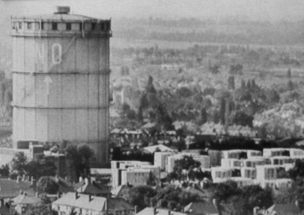
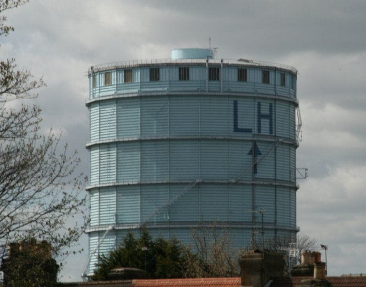
Ah! The good old "Gasholder Landing System!" I visited Northolt Tower a couple of times while working at LATCC in 1966/7. On one visit, Heathrow were using Rw 23L (long since redeveloped as a taxiway) and it was quite exciting how the final approach track crossed that of Northolt Rw 26 on short(ish!) final for both! Around that time, a PanAm 707 crew landed at Northolt by mistake! Since the two gasholders were in the same position relative to the two runways, the arrows were painted on as a backstop against crews taking the wrong visual cues. Fight Magazine had a humorous comment by Uncle Roger about how NO was YES if you were looking for Northolt, but NO if you wanted Heathrow!


Joined: Jun 2014
Aviation Qualifications: Spotter
Posts: 3,896
Likes: 86
From: Netherlands
I hope i do not drift to far off course of this thread, but I hope somebody can point me in the right direction?
Photo below is from a book of 1931 "In de schroefwind" of KLM pilot A. Viruly.
It is a photo of two gasholders in Leeuwarden (now the Bleekhof in Leeuwarden)
The arrows point roughly North while the Leeuwarden air base is approximately 4 km in NW direction.
Did they have already have a flight pattern in place?
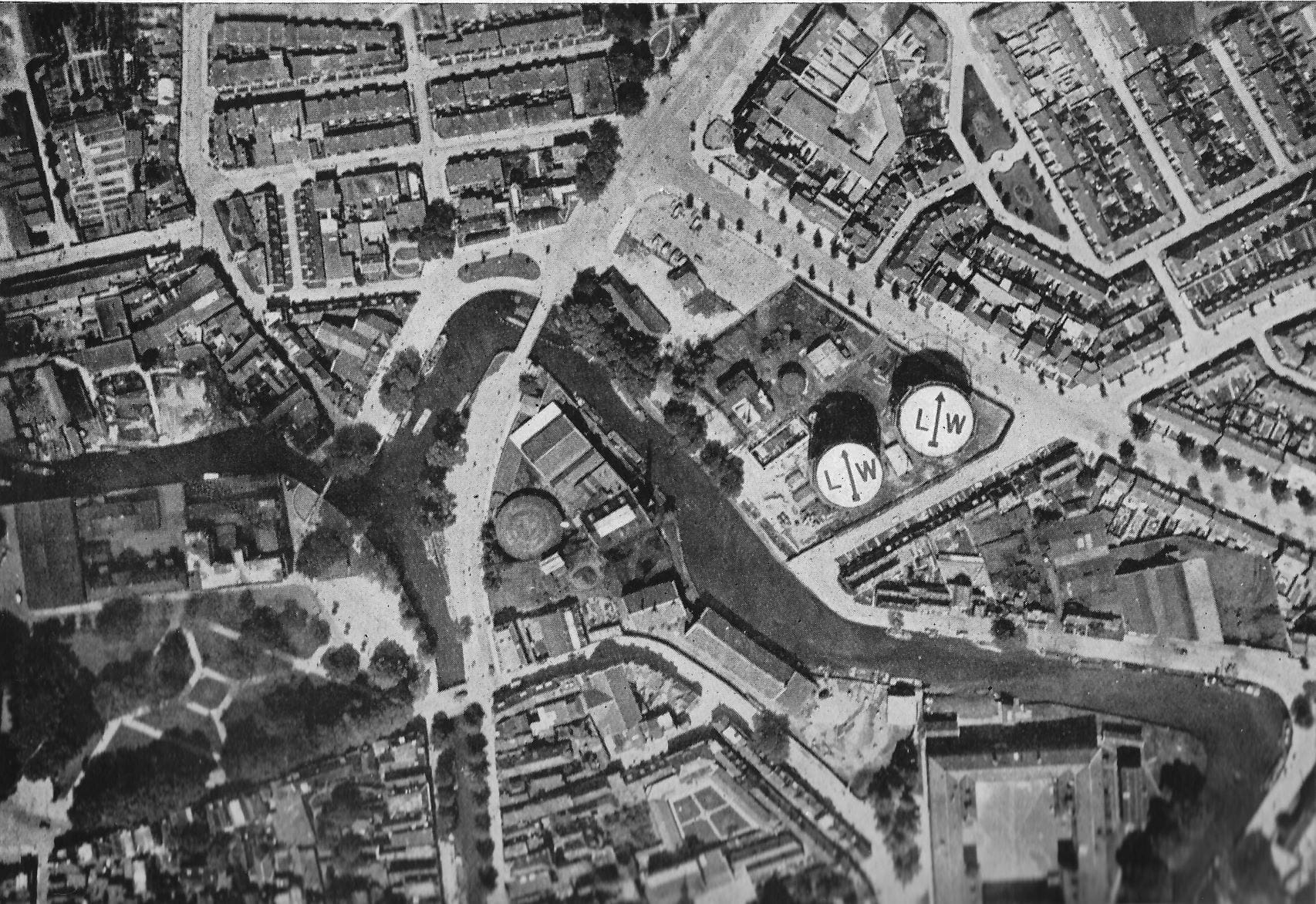
Joined: Oct 2002
Aviation Qualifications: PPL
Posts: 8,201
Likes: 347
From: London UK
I hope i do not drift to far off course of this thread, but I hope somebody can point me in the right direction?
Photo below is from a book of 1931 "In de schroefwind" of KLM pilot A. Viruly.
It is a photo of two gasholders in Leeuwarden (now the Bleekhof in Leeuwarden)
The arrows point roughly North while the Leeuwarden air base is approximately 4 km in NW direction.
Did they have already have a flight pattern in place?
The ones for London/Northolt are a design that has a static casing on the outside of the gasholder.
Joined: Jan 2008
Aviation Qualifications: SLF
Posts: 58
Likes: 1
From: Frome - where we do as Fromans do
Lighthouses as naviagtional aids
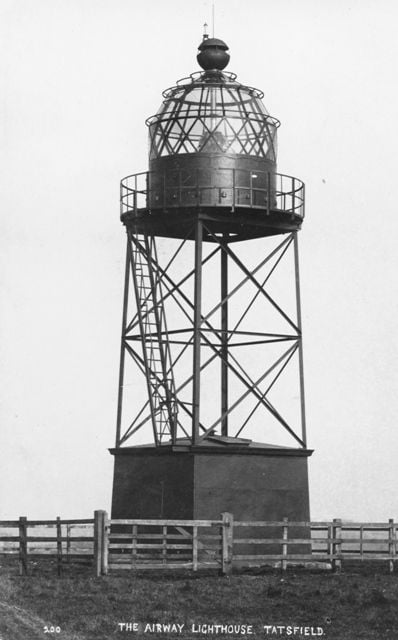
As a slight aside to the discussion but still relevant and I expect of some interest, in the 1920's, Aerial Lighthouses, such as this one in Tatsfield, were installed to guide aircraft around the country. Similar systems also existed in other countries.
There is a restored example of just such a beacon at North Weald.
A wealth of information about the ones in the South East of England is here...
Aerial Lighthouses
There is a restored example of just such a beacon at North Weald.
A wealth of information about the ones in the South East of England is here...
Aerial Lighthouses
Joined: Nov 2005
Aviation Qualifications: PPL
Posts: 12,446
Likes: 367
From: Wildest Surrey
It's strange to actually paint the arrow on top of the gas holders as they spiral round as they go up and down as the gas fills/empties. If you look closely at the mechanism you will see this.
The ones for London/Northolt are a design that has a static casing on the outside of the gasholder.
The ones for London/Northolt are a design that has a static casing on the outside of the gasholder.
The former rotate and rise up and down, the height being used to measure how much 'reserve' gas it holds whereas the latter is just a static tank, although there must be a means of showing how much gas it is holding.
It was a 'gasometer' near (I think) St Annes radar station which used to cause confusion to radar controllers at the 'old' Preston ATCC radar unit because as it filled up and rose up, it would reflect radar echos to make it seem the aircraft were in a different position from where they actually were; when it was empty or nearly so, this reflection wouldn't happen.

Joined: Mar 2002
Aviation Qualifications: CPL
Posts: 3,378
Likes: 316
From: near an aeroplane
Photo below is from a book of 1931 "In de schroefwind" of KLM pilot A. Viruly.
It is a photo of two gasholders in Leeuwarden (now the Bleekhof in Leeuwarden)
The arrows point roughly North while the Leeuwarden air base is approximately 4 km in NW direction.
Did they have already have a flight pattern in place?
It is a photo of two gasholders in Leeuwarden (now the Bleekhof in Leeuwarden)
The arrows point roughly North while the Leeuwarden air base is approximately 4 km in NW direction.
Did they have already have a flight pattern in place?
So to go back to your photo, as there was no airfield at the town in 1931, I would suspect these markings to be nothing more than a reminder of the name of the town and a rough idea of where North is.
Edit, see here: https://www.agl-fullstop.nl/index.php/vlb-leeuwarden
Another addition from a 1919 newspaper:
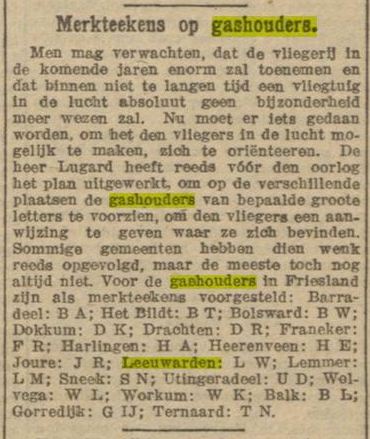
In short, even before WWI there were plans to mark gasholders with two-letter codes to enable airmen to orient themselves. This article from 1919 lists the ones as suggested for towns in Friesland.
Last edited by Jhieminga; 25th September 2019 at 08:51. Reason: Added link, and added image
Joined: Jun 2009
Posts: 6,328
Likes: 2
From: France
I recall us sitting in class at Harrow County School watching the 707 going into Northolt (more interesting than Bigham's biology lesson). We all thought it a little odd, but did not at the time realise how odd, Also went to see the Annie on the egg packing factory in S Ruislip