


 2nd Mar 2020, 14:35 - Wikipost
|
|||
|
|||
 Thanks to Self Loading Bear for suggesting that we use a wiki.
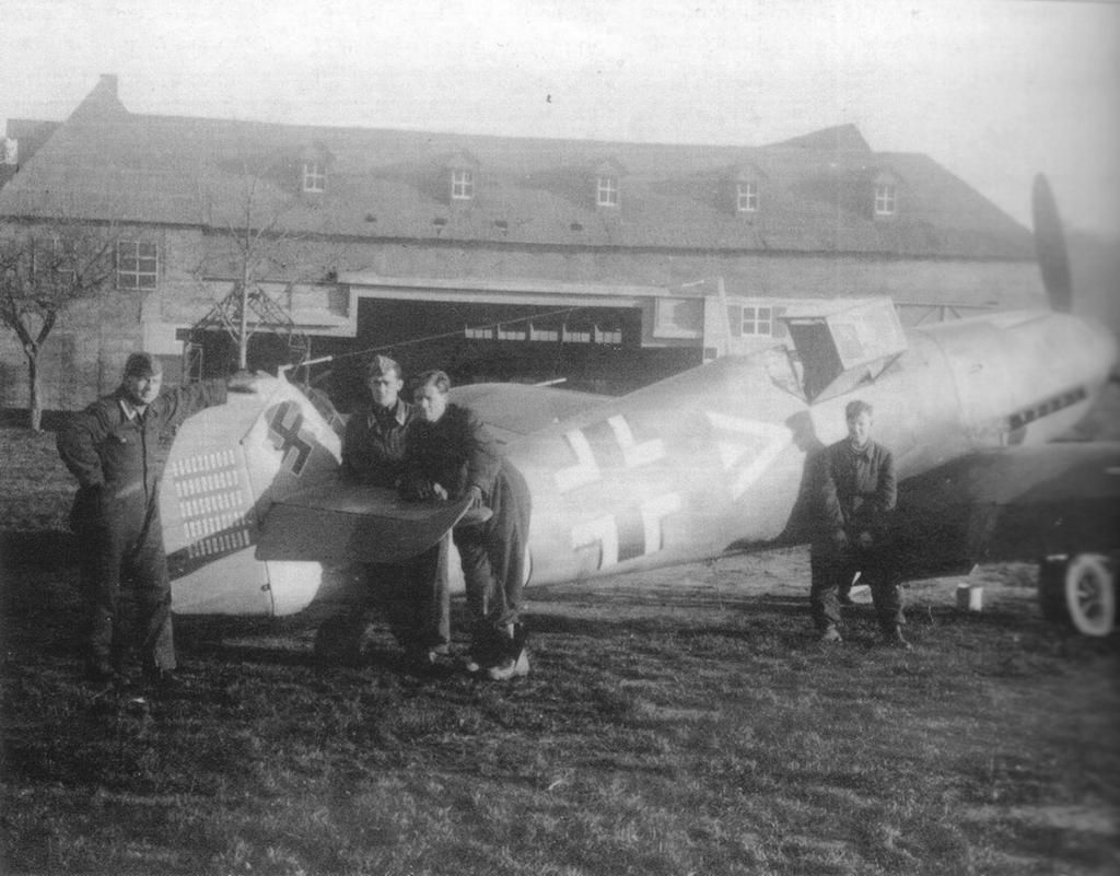
Which Aerodrome Mk III
I agree that it is Great Orme, but with Puffin Island in the view it can't be from Beaumaris I don't think. Any chance they are from separate locations?
This is the best google street view I can get from Moelfre - it still needs to a bit further north, from somewhere near the lifeboat station I think.

This is the best google street view I can get from Moelfre - it still needs to a bit further north, from somewhere near the lifeboat station I think.

Join Date: Apr 2002
Location: North Wales / Ontario
Age: 84
Posts: 203
Likes: 0
Received 0 Likes
on
0 Posts
Both Pictures taken from 53.16.33.30N 4.05.07.95W
Puffin island is out of sight beyond the coast line to the left of frame.
I know where I was, I taught map reading and navigation for 40 years.
HD
Puffin island is out of sight beyond the coast line to the left of frame.
I know where I was, I taught map reading and navigation for 40 years.
HD
Perhaps we are seeing different images, but in the picture I am seeing at post#5433, Puffin Island is clearly in sight, just right of centre.

The exif data shows that the 2 images were taken just over 2 hours apart if that is any help.
The exif data shows that the 2 images were taken just over 2 hours apart if that is any help.
BN,
I agree. I think it is Moelfre beach at low-tide and the rock on the right is part of the very prominent ledge visible on the GE image.
I agree. I think it is Moelfre beach at low-tide and the rock on the right is part of the very prominent ledge visible on the GE image.
I42,
The picture I posted at #5442 is Moelfre beach, which is the closest I could get from google street view. But if you look at the high ground beyond, I think the original viewpoint is even further left. I'm wondering if the 'rock' to the right is on or around the lifeboat slipway?
Not sure if there is any significance in the 2 buoys out in the water?
BN,
I had thought about the lifeboat slipway too, but it didn't look right. Also there is no "beach" there.
However, while looking at GE again, I've found the location. It's the bay just north of the lifeboat station. The rocks in the left of the picture are part of Ynys Moelfre island. See the spherical panorama taken at Moelfre Cottages.
Join Date: Sep 2012
Location: Sisteron, France
Age: 67
Posts: 79
Likes: 0
Received 0 Likes
on
0 Posts
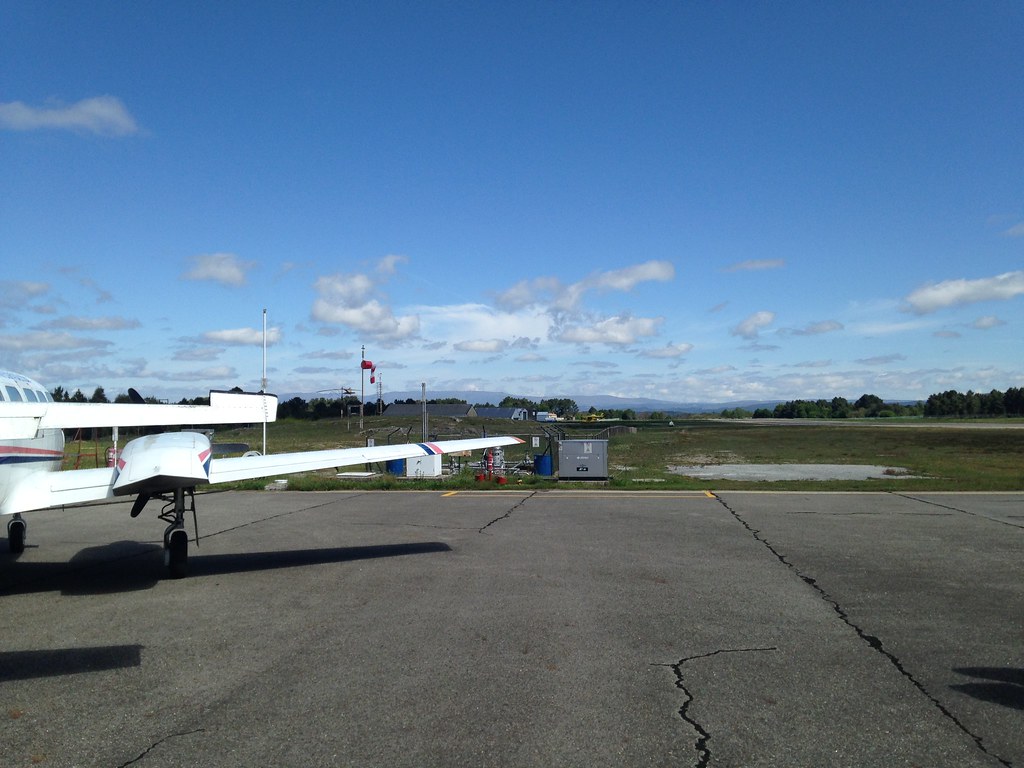
A new tricky one from NW France...
Hello everyone!
Longtime no see (for various reasons..)!
I see the forum is not what it used to be...and yet there are still some airfields to discover! Here is one:
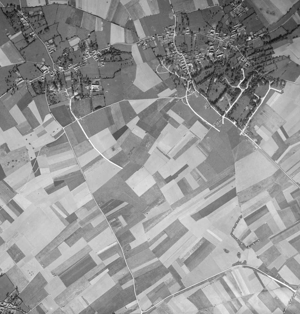
This one is interesting in many ways, especially because this is probably the last place in Europe where one can see two types of german fighter hangars in their original state (unfortunately decaying fast).
There is also a workshop hangar which is now almost unique (only one other one on Creil AB) - and still camouflaged on the photo above.
Longtime no see (for various reasons..)!
I see the forum is not what it used to be...and yet there are still some airfields to discover! Here is one:
This one is interesting in many ways, especially because this is probably the last place in Europe where one can see two types of german fighter hangars in their original state (unfortunately decaying fast).
There is also a workshop hangar which is now almost unique (only one other one on Creil AB) - and still camouflaged on the photo above.
asw22,
I think your picture belongs in a new thread - "Where's the Aerodrome?"
Merry Christmas to all in PPRuNe land.
I think your picture belongs in a new thread - "Where's the Aerodrome?"
Merry Christmas to all in PPRuNe land.
Join Date: Sep 2012
Location: Sisteron, France
Age: 67
Posts: 79
Likes: 0
Received 0 Likes
on
0 Posts
Hello India! You know, I believe we have been in the same thread for the last 273 pages...the guess proposals (10 of them) I already made where all in this same thread.
I apologize in advance if I stole an open round...I had the feeling there was none open!
Merry Christmas to everyone!
asw22
EDIT 12/24: I did not spot the joke until now...Shame on me and my apologies to India...
I apologize in advance if I stole an open round...I had the feeling there was none open!
Merry Christmas to everyone!
asw22
EDIT 12/24: I did not spot the joke until now...Shame on me and my apologies to India...
Last edited by asw22; 24th Dec 2015 at 21:06.
I42 - it's a bit like an ink blot test, isn't it?
asw22 - somewhere in France?
asw22 - somewhere in France?
Join Date: Sep 2012
Location: Sisteron, France
Age: 67
Posts: 79
Likes: 0
Received 0 Likes
on
0 Posts
It is indeed an aerodrome in North Western France...Here are the two fighter hangars and the workshop hangar:
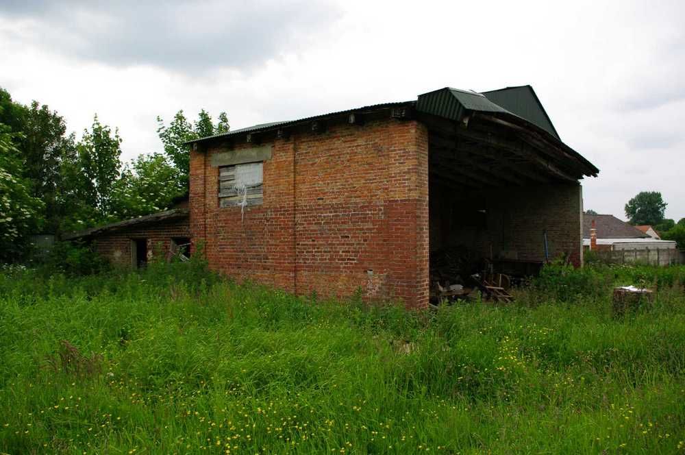
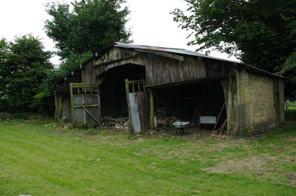
On the last one the shack in front of the doors is an after-war addition (this is now a potatoes hangar!).
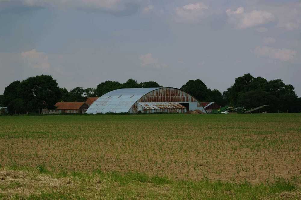
You may have a hard time finding it on the airfield photo (and yet it is there!). It was then resembling closely to something like that:
This specific hangar was located at the (quite close) airfield of Brias I have already offered to your cleverness with this same photo as an help...However this sentence will be my first clue!
On the last one the shack in front of the doors is an after-war addition (this is now a potatoes hangar!).
You may have a hard time finding it on the airfield photo (and yet it is there!). It was then resembling closely to something like that:
This specific hangar was located at the (quite close) airfield of Brias I have already offered to your cleverness with this same photo as an help...However this sentence will be my first clue!
Join Date: Dec 2011
Location: herts
Posts: 1,838
Likes: 0
Received 0 Likes
on
0 Posts
Long time no posting for me as well.
The aerial photo is of Monchy-Breton
Here's the large hangar. 50�23'42.37" N 2�25'55.43" E
This looks like different hangar from your image: 50�23'48.94" N 2�26'28.45" E
The aerial photo is of Monchy-Breton
Here's the large hangar. 50�23'42.37" N 2�25'55.43" E
This looks like different hangar from your image: 50�23'48.94" N 2�26'28.45" E
Join Date: Sep 2012
Location: Sisteron, France
Age: 67
Posts: 79
Likes: 0
Received 0 Likes
on
0 Posts
Woha I am impressed!
This is supposed to be quite obscure !
!
How did you find (via Tineye, maybe?)?
The hangar in my first photo is here: 50.398553 2.447144
and there just close by for the second one: 50.398294 2.446683
The third one you have it right.
congratulations!
You have the helm...
This is supposed to be quite obscure
!How did you find (via Tineye, maybe?)?
The hangar in my first photo is here: 50.398553 2.447144
and there just close by for the second one: 50.398294 2.446683
The third one you have it right.
congratulations!
You have the helm...
Join Date: Dec 2011
Location: herts
Posts: 1,838
Likes: 0
Received 0 Likes
on
0 Posts
Pure luck. went to Brias on GE, road layout of Monchy-Breton looked right and it was.
Here is the only picture I've ever taken when landing - damn camera focussed on the windscreen, so makes it a bit harder.
I think it has been done before, but the airfield is no more, closed a week or so after this picture.

I have some shots with the airfield in the distance, bit too easy though.
Here is the only picture I've ever taken when landing - damn camera focussed on the windscreen, so makes it a bit harder.
I think it has been done before, but the airfield is no more, closed a week or so after this picture.
I have some shots with the airfield in the distance, bit too easy though.
 [/url]