


 2nd Mar 2020, 14:35 - Wikipost
|
|||
|
|||

Which Aerodrome Mk III


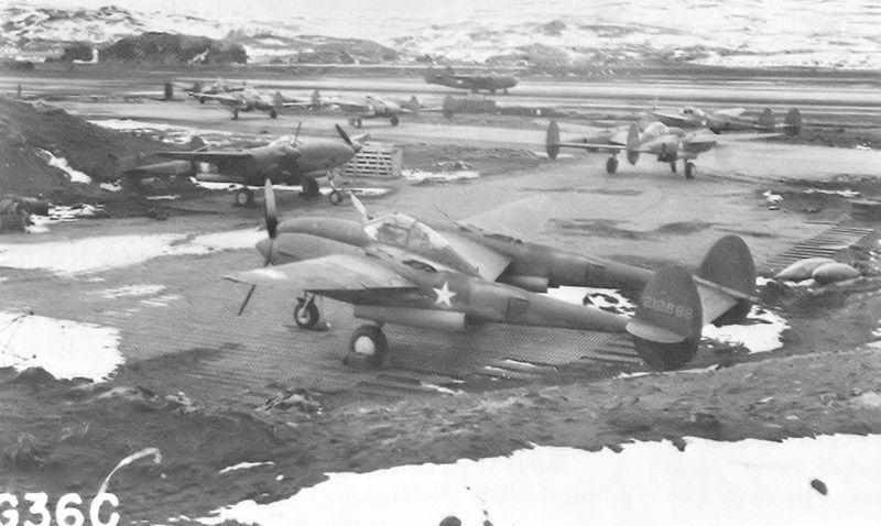
Photo Description:
A left side view 5x7 photo of a United States Army Air Force
Curtiss P-40E Warhawk aircraft assigned to the 11th Fighter Squadron 343rd
Fighter Group undergoing maintenance at an airfield somewhere in the Aleutian
Islands. This P-40 Warhawk known as one of the Aleutian Tigers sometimes Bengal
Tigers is wearing a variation of the Flying Tigers nose art made famous by
General Claire Chennault's AVG in the CBI war theater. His son Major John "Jack"
Chennault was the original commander of the 11th Fighter Squadron.
............
Photo Credit: USGovPhoto Date: ca 1942Photo Location: Aleutian Islands, AlaskaPhoto ID: 57-P401010
Last edited by Lightning Mate; 9th Jan 2013 at 11:57.

All I can say is that one US aviation historian places the aircraft at Adak, so it's down to the reliability of sources.
Yours might well have it as Fort Glenn.
I shall now watch to see what anyone else comes up with.
Yours might well have it as Fort Glenn.
I shall now watch to see what anyone else comes up with.
Join Date: Dec 2011
Location: herts
Posts: 1,838
Likes: 0
Received 0 Likes
on
0 Posts
The source of all the images I posted state that they are on Umnak Island - which is where Ft Glenn is - although it doesn't state whether they are at Ft Glenn or one of the two satellite fields.
The sentry in my 2nd image looks like he is wearing the WWI style helmet, so the image is early rather than later, which would suggest Ft Glenn again.
LM - you have control
The sentry in my 2nd image looks like he is wearing the WWI style helmet, so the image is early rather than later, which would suggest Ft Glenn again.
LM - you have control
United States?
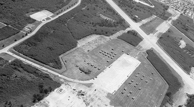
Tanks ...??!! There's me thinking they wuz pigsties or hayricks. Intrigued by the three diamond shaped markings on the large pan and the shanty town on the boundary. Best I can guess is a former "Eastern Bloc" field - LFH
Join Date: Sep 2012
Location: Sisteron, France
Age: 67
Posts: 79
Likes: 0
Received 0 Likes
on
0 Posts
Hello all!
Happy new year everybody!
The three diamonds are actually three squares with the "H" symbol in a dotted triangle...so it seems like US Army training grounds on a former airfield...as for the airfield itself it looks like one of these many old navy training bases around Chesapeake Bay (and elsewhere on the West Coast); I have thought for a while it may have been a former German Fliegerhorst but the disposition, hangar location, size of runways and tarmac are all wrong...I would say US, really...
Last edited by asw22; 12th Jan 2013 at 09:08.
While we're waiting for LM to reach rotate speed, briefly back to the Aleutians where I found Nvubu's photo of the P-40 under maintenance.
On balance I suggest the pic would have been at Fort Glenn, rather than either of the satellites.
I also found this approach (??**!!) plate from 1943 - Radio Range I suppose. It shows Fort Glenn plus its two subsequent satellites (North and South West) as referred to in the Wiki entry for Ft. G.
I would post the plate but I can't get into PB again.
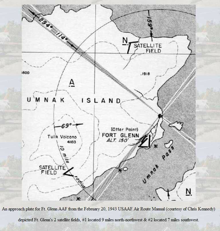
It appears the southwesterly satellite field was later covered in lava and there is nothing of it on GE. The northern one is still evident on GE and I wonder if a misunderstanding has crept in over the years.
The northern satellite would logically have qualified for the name "North Shore."
Wiki refers to "North Shore" with a logical Lat & Long for the north satellite, but GE has "North Shore" annotated at the location of Ft. Glenn. I think the GE notation is incorrect.
LFH
Late edit - new beta pbuck still playing up - its only the old site plus ffox that works for me. A fascinating challenge Nvubu - now for LM's Pacific island.
On balance I suggest the pic would have been at Fort Glenn, rather than either of the satellites.
I also found this approach (??**!!) plate from 1943 - Radio Range I suppose. It shows Fort Glenn plus its two subsequent satellites (North and South West) as referred to in the Wiki entry for Ft. G.
I would post the plate but I can't get into PB again.
It appears the southwesterly satellite field was later covered in lava and there is nothing of it on GE. The northern one is still evident on GE and I wonder if a misunderstanding has crept in over the years.
The northern satellite would logically have qualified for the name "North Shore."
Wiki refers to "North Shore" with a logical Lat & Long for the north satellite, but GE has "North Shore" annotated at the location of Ft. Glenn. I think the GE notation is incorrect.
LFH
Late edit - new beta pbuck still playing up - its only the old site plus ffox that works for me. A fascinating challenge Nvubu - now for LM's Pacific island.
Last edited by Lordflasheart; 20th Jan 2013 at 20:49.