


Imperial Airways fort at Rutbah Wells

Thread Starter
Join Date: Jan 2000
Location: Somewhere around the World
Posts: 60
Likes: 0
Received 0 Likes
on
0 Posts
Imperial Airways fort at Rutbah Wells
Can anyone give me an accurate reference for the old Imperial Airways Fort at Rutbah Wells in Iraq please?
Have been trying to find it on Googleearth to see whether there are any remains but so far without success.
Thanks in advance.
M.C.
Have been trying to find it on Googleearth to see whether there are any remains but so far without success.
Thanks in advance.
M.C.


Join Date: Jul 1999
Location: 58-33N. 00-18W. Peterborough UK
Posts: 3,040
Likes: 0
Received 0 Likes
on
0 Posts
As you probably know, the name was changed to Ar Rutbah. If you go to Google Earth and tick Transport/Airports and do an Iraq centred search on Ar Rutbah you'll see Ar Rutbah Highway Strip at N33-03-28-95 E40-23-54-21. 3 miles due East of the centre of Ar Rutbah town.
I'd put money on this being the old Rutbah Wells.
I'd put money on this being the old Rutbah Wells.
Join Date: May 2010
Location: EU
Age: 82
Posts: 5,505
Likes: 0
Received 0 Likes
on
0 Posts
Phil I looked at that, too, but if you look at other sources, it may be that an accident was 16 km south of the airfield.
From the pictures (not the painting that also appears in the net) it seems that it was closer to the river bank formation and may have been closer to "down-town" Ar Rutba.
From the pictures (not the painting that also appears in the net) it seems that it was closer to the river bank formation and may have been closer to "down-town" Ar Rutba.
Thread Starter
Join Date: Jan 2000
Location: Somewhere around the World
Posts: 60
Likes: 0
Received 0 Likes
on
0 Posts
"Forget"- thanks for that- it certainly could be the location.
The shape of the fort looks different though and there are no indications that the v-shaped structure on the end was ever there.
The access road and the small escarpement to the south don't seem to be there either.
Nevertheless, it is entirely possible that the whole structure could have disappeared, been altered or demolished since the 1930's.
Phileas Fogg- I have also read that the fort was 16km south of Rutbah.
Taking a measure at this range on Google-earth shows nothing there as far as I can see.
Thanks to you all-
the mystery continues....
Join Date: Jul 1999
Location: 58-33N. 00-18W. Peterborough UK
Posts: 3,040
Likes: 0
Received 0 Likes
on
0 Posts
I think what's confusing matters here is the DC2 crash mentioned in Wikipedia -
In Wiki the full stop after 'fort' is easily missed so it (wrongly) reads - travellers who stopped lodged in a fort 16 Kilometers South of Rutbah (Rutbah Wells, in 1934).
As I see it, the fort was at Rutbah Wells; the DC2 crashed 16K South of Rutbah Wells.
I see that RAF Tornado ZA467 crashed here on 22 Jan 1991. Possible NVG problems, AAA night flashes might have caused distractions - suspected that they might have impacted with ground on break manoeuvre. What were they attacking? The strip?
ASN Aircraft accident 22-JAN-1991 Panavia Tornado GR1 ZA467
PS.If you're reeeally keen to get info on Rutbah Wells I'd try to contact someone with BA or KLM archives.
During British administration, Rutbah Wells, as it was then known, was a stop-over for Imperial Airways on flights from Britain to India and the Gulf Region. ....... travellers who stopped lodged in a fort. (�forget� note - see below.) 16 kilometers South of Rutbah (Rutbah Wells, in 1934), the famous aircraft... "Uiver" a DC-2 type from KLM, crashed here on its first flight after the MacRobertson Air Race in December 1934 on its way to Indonesia.
As I see it, the fort was at Rutbah Wells; the DC2 crashed 16K South of Rutbah Wells.
I see that RAF Tornado ZA467 crashed here on 22 Jan 1991. Possible NVG problems, AAA night flashes might have caused distractions - suspected that they might have impacted with ground on break manoeuvre. What were they attacking? The strip?
ASN Aircraft accident 22-JAN-1991 Panavia Tornado GR1 ZA467
PS.If you're reeeally keen to get info on Rutbah Wells I'd try to contact someone with BA or KLM archives.
Join Date: May 2010
Location: EU
Age: 82
Posts: 5,505
Likes: 0
Received 0 Likes
on
0 Posts
EDIT: I wrote this while forget wrote his own.... Part of it is redundant 
Missioncontrol,
I do not want to sound pedant, but the Wikipedia says
So, Rutbah Wells should be in Ar Rutba or its vicinity.
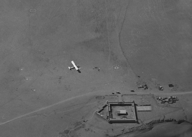
There is a contemporary (1930) mention of Rutbah and a (the?) fort in Untitled, although the picture of the fort does seem to be from a smaller one than in the aerial picture in #2. Anyhow, I'd put Rutbah Wells along the old road, and pretty close, if not in, Ar Rutba.
A cleaned-up GoogleTranslation from German:
Hans Helfritz this published this photo in 'Under the sun of the Orient "(Berlin 1931), page 111:" Rutbah, the fort in the desert. " At this point (p. 110-112) he reports: "Finally, in the evening at seven clock, as the storm set and the setting sun painted purple tones in the yellow uniform, but at the same moment the night in the desert sinks, we approach Rutbah, a fortress, which the English have just built in the middle between Damascus and Baghdad, in the middle of the desert. Slowly we descend into a small valley, here and there glow eerily on a couple of fire of the Bedouin, here the Englishmen can rest protected and quietly. The gate of the fort, which we passed is watched by Zouaves, armed up to their teeth. Here accumulate gradually all the cars, and one hour is our peace gone. Here are also armored cars prepared to accompany, particularly in uncertain times, the "convoy" to Baghdad. In the darkness of the night, interrupted only by individual lamps of cars, the tall and strong desert police, with their daggers and triple cartridge belts, look very strange. Some of they have come suddenly into an argument, one raging like an idiot, waving hands and feet around and has to be carried away handcuffed. Men explode at the slightest opportunity; it is a miracle that nobody is just stabbed with a dagger. We continue or journey at eight. Some cars had already left half an hour ago, others who arrived later, will remain in the fort. The driver sits at the wheel as indifferent as during the day. He drives the thousand-kilometer route from Damascus to Baghdad in two days and a night without closing his eyes. The drivers in the East are actually not bad at all. There are more bad mechanics who have their car break down after a year, and good to keep them going longer. ... Nothing can be seen any more of the other cars. Pale moonlight spreads over the dull area in which flashes up every now and then bleached bone or empty fuel tanks. It may be about two clock, when we notice a faint light ahead of us. Coming closer, we recognize one of our cars, which has been stuck here ... "
Sorry for the verbiage and thread drift; this is also a piece of history and nostalgia for me: I did the 900 km road trip from Amman to Baghdad in early 1980s, and THAT was in an air conditioned bus. Yet a long one.... Must have been pretty close to Ar Rutba at one point.
Best
Reg
Missioncontrol,
I do not want to sound pedant, but the Wikipedia says
During British administration, Rutbah Wells, as it was then known, was a stopover for Imperial Airways on flights from Britain to India and the Gulf Region [1]. It was also a water stop on the overland drive from Baghdad to Damascus; travelers who stopped lodged in a fort [2][3].
16 kilometers South off Rutbah (Rutbah Wells, in 1934), the famous aircraft, a winner off the MacRobertson Air Race the "Uiver" a DC-2 type from the KLM, now knows as Air France-KLM, crashed here on its first flight after the MacRobertson Air Race in December 1934 on its way to the Dutch East Indies (now Indonesia).
16 kilometers South off Rutbah (Rutbah Wells, in 1934), the famous aircraft, a winner off the MacRobertson Air Race the "Uiver" a DC-2 type from the KLM, now knows as Air France-KLM, crashed here on its first flight after the MacRobertson Air Race in December 1934 on its way to the Dutch East Indies (now Indonesia).
There is a contemporary (1930) mention of Rutbah and a (the?) fort in Untitled, although the picture of the fort does seem to be from a smaller one than in the aerial picture in #2. Anyhow, I'd put Rutbah Wells along the old road, and pretty close, if not in, Ar Rutba.
A cleaned-up GoogleTranslation from German:
Hans Helfritz this published this photo in 'Under the sun of the Orient "(Berlin 1931), page 111:" Rutbah, the fort in the desert. " At this point (p. 110-112) he reports: "Finally, in the evening at seven clock, as the storm set and the setting sun painted purple tones in the yellow uniform, but at the same moment the night in the desert sinks, we approach Rutbah, a fortress, which the English have just built in the middle between Damascus and Baghdad, in the middle of the desert. Slowly we descend into a small valley, here and there glow eerily on a couple of fire of the Bedouin, here the Englishmen can rest protected and quietly. The gate of the fort, which we passed is watched by Zouaves, armed up to their teeth. Here accumulate gradually all the cars, and one hour is our peace gone. Here are also armored cars prepared to accompany, particularly in uncertain times, the "convoy" to Baghdad. In the darkness of the night, interrupted only by individual lamps of cars, the tall and strong desert police, with their daggers and triple cartridge belts, look very strange. Some of they have come suddenly into an argument, one raging like an idiot, waving hands and feet around and has to be carried away handcuffed. Men explode at the slightest opportunity; it is a miracle that nobody is just stabbed with a dagger. We continue or journey at eight. Some cars had already left half an hour ago, others who arrived later, will remain in the fort. The driver sits at the wheel as indifferent as during the day. He drives the thousand-kilometer route from Damascus to Baghdad in two days and a night without closing his eyes. The drivers in the East are actually not bad at all. There are more bad mechanics who have their car break down after a year, and good to keep them going longer. ... Nothing can be seen any more of the other cars. Pale moonlight spreads over the dull area in which flashes up every now and then bleached bone or empty fuel tanks. It may be about two clock, when we notice a faint light ahead of us. Coming closer, we recognize one of our cars, which has been stuck here ... "
Sorry for the verbiage and thread drift; this is also a piece of history and nostalgia for me: I did the 900 km road trip from Amman to Baghdad in early 1980s, and THAT was in an air conditioned bus. Yet a long one.... Must have been pretty close to Ar Rutba at one point.
Best
Reg
Join Date: Jul 2004
Location: Cloud 9
Posts: 2,948
Likes: 0
Received 0 Likes
on
0 Posts
From: https://dspace.lboro.ac.uk/dspace-js...etin%20253.pdf
The airstrip and rest house in the desert oasis of Rutbah Wells in the Syrian
Desert was specially built for Imperial Airways by the Iraqi Government and defended against hostile tribes by armed infantry. One passenger wrote of the �unforgettable experience of arriving at the most desolate and extraordinary hostelry in the world', while another remarked on �the absurdity of coming down [in the morning] to an English ham and egg breakfast in the middle of the desert' (cited in Frater 1986 p85).
Join Date: May 2010
Location: EU
Age: 82
Posts: 5,505
Likes: 0
Received 0 Likes
on
0 Posts
Phileas, coming to think of it, it is very possible that there has been one or more forts in Al Rutba and the Imperial Airways "terminal building" in Rutbah Wells is one or none of them. Equally, the German travel report may very well not be from the airfield.
Join Date: Jul 1999
Location: 58-33N. 00-18W. Peterborough UK
Posts: 3,040
Likes: 0
Received 0 Likes
on
0 Posts
Here you are. The hills won't have moved. Pin them down and you have the original strip. 
Also, I wonder if any of the Nav furrow can still be seen.
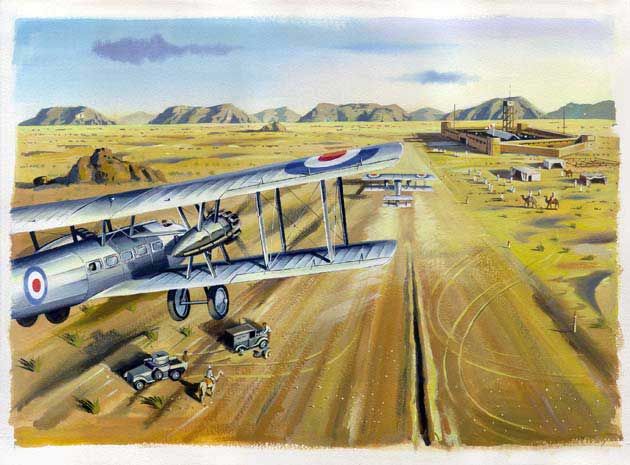
l'aventure des Imperial airways, chronicles of the imperial Airways
Also, I wonder if any of the Nav furrow can still be seen.
l'aventure des Imperial airways, chronicles of the imperial Airways
Join Date: May 2010
Location: EU
Age: 82
Posts: 5,505
Likes: 0
Received 0 Likes
on
0 Posts
The beacon tower in the painting is mentioned on some sources, but not seen in the aerial picture. I wonder how much artist's freedom has been used. You also might notice, that this source calls the building "originally a legionnaire fort", which may or may not contradict Phileas' source (the building may be built where a fort had been).
This would confirm the desert location as opposed to Ar Rutba village.
This would confirm the desert location as opposed to Ar Rutba village.
Last edited by RegDep; 25th Oct 2010 at 14:14.
Join Date: May 2010
Location: EU
Age: 82
Posts: 5,505
Likes: 0
Received 0 Likes
on
0 Posts
Further:
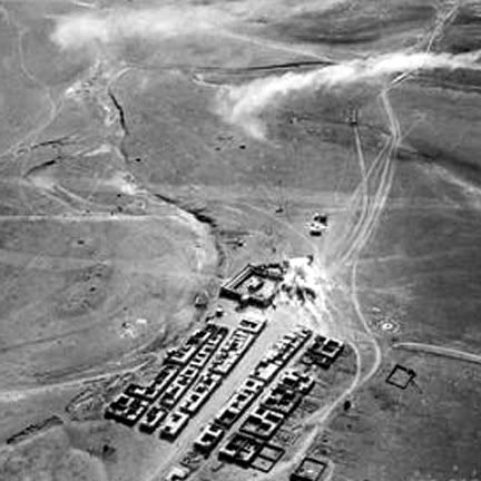
Here is a picture of Rutbah in 1941 File:Rutbah under attack.jpg - Wikipedia, the free encyclopedia
It shows the building still as it was, but more buildings next to it.
My current offer is 33 02 17.36 N 40 17 13.55 E, which, in fact, was my original idea when starting to insist "down-town".
Here is a picture of Rutbah in 1941 File:Rutbah under attack.jpg - Wikipedia, the free encyclopedia
It shows the building still as it was, but more buildings next to it.
My current offer is 33 02 17.36 N 40 17 13.55 E, which, in fact, was my original idea when starting to insist "down-town".
Join Date: May 2010
Location: EU
Age: 82
Posts: 5,505
Likes: 0
Received 0 Likes
on
0 Posts
What this all seems to boil down is that everybody had it right: There was one fort, in the middle of the desert, built by the British, and it is now "down-town" Ar Rutba .
.
I have a copy of "The Baghdad Air Mail" by Wg Cdr Roderic Hill published in 1929.
The following description appears on Page 87:
"Near Rutbah Wells, beside the Air Mail Track between L.G. 8 and L.G IX a combined police post, wireless station and rest house has been built, and a landing ground cleared in front of it for the use of Imperial Airways. The grey stone building, with an avenue leading up to it from the landing ground, is strangely impressive, and seems to dominate the uplands overlooking Wadi Hauran."
Now before some clever soul tells me that L.G. 8 should be written as L.G. VIII, I quote from Page 21:
"The party from Amman lettered all the landing grounds that they marked from "A" to "R", with the omission of "I" and "Q". The party from the other end (Baghdad) numbered their landing grounds from "I" to "XI", which is not far from where the two parties met at the wells of El Jid. All the numbered landing grounds are marked in Roman numerals, except landing ground No. 8, which is marked as written".
As someone once said, not many people know that!
Join Date: Jul 2004
Location: Cloud 9
Posts: 2,948
Likes: 0
Received 0 Likes
on
0 Posts
Wadi Hauran near the desert post Qasr Muheiwir (ca. 33� latitude / 41� longitude).
Map: W?d? Mu?eiwir, Jordan - Geographical Names, map, geographic coordinates
Map: W?d? Mu?eiwir, Jordan - Geographical Names, map, geographic coordinates
Join Date: Jul 1999
Location: 58-33N. 00-18W. Peterborough UK
Posts: 3,040
Likes: 0
Received 0 Likes
on
0 Posts