


Qantas Crew Help Lost Pilot in the 1950/60s

Thread Starter
Join Date: Aug 2007
Location: Manchester
Posts: 115
Likes: 0
Received 0 Likes
on
0 Posts
Qantas Crew Help Lost Pilot in the 1950/60s
Can anyone recall the details of a Qantas crew helping out a pilot lost somewhere over the Pacific, I think? There was something about the Qantas crew asking the guy to hold his arm out and count the number of knuckles between the horizon and the sun followed by some other very clever pilot nav techniques.
If anyone has the full details I would be most interested to read them again
If anyone has the full details I would be most interested to read them again

Join Date: Jun 2009
Location: Canada
Posts: 464
Likes: 0
Received 0 Likes
on
0 Posts
I don't know about the historical details, but I do remember a movie I saw on TV some years ago where an airliner flying over the Pacific finds a lost pilot and leads him to the nearest airport in New Zealand. Can't remember what it was called, but it sounds like the same story and it was supposed to be based on real events. I'd be interested to know what movie it was, becasue I'd like to watch it again sometime  .
.
.
Here's the story. (ANZ, not QANTAS)
The film was in 1993: Mercy Mission: The Rescue of Flight 771 and starred Scott Bakula of Quantum Leap fame.
�Mayday mayday.� This message of a pilot in distress on radio three days before Christmas 1978 is heard by Auckland ATC. The saga of how Jay Prochnow was finally located by the innovative navigational techniques of Captain Gordon Vette aided by Malcolm Forsyth both of Air New Zealand, Auckland ATC, Norfolk Island and the crew of the Royal New Zealand Air Force (RNZAF) Orion is made into a Brain Game. The Penrod, a towed oil rig with running lights, served as a beacon which enabled Captain Vette to rendezvous with Jay Prochnow.

Flashes from my memory.
Lost a/c was a Pawnee
I have a feeling the crew assisting were flying a DC10, which could make them Air N-Z and the time maybe early 80s.
In rough terms an arm held outstretched with the fist clenched, each knuckle subtends an angle of about 1 degree and provides an approximate way of measuring the sun's elevation. Check difference of elevation between lost a/c and seeking a/c at same time this will give a indication of difference of lattitude, you have one position line, difference of sun's azimuth will give differnce of longitude. all very approximate but in that case it worked. A great bit of work from the ANZ crew.I think they were recognised by the Institute of Navigation.

Join Date: Jul 1999
Location: 58-33N. 00-18W. Peterborough UK
Posts: 3,040
Likes: 0
Received 0 Likes
on
0 Posts


Join Date: Jul 1999
Location: 58-33N. 00-18W. Peterborough UK
Posts: 3,040
Likes: 0
Received 0 Likes
on
0 Posts
I have to admit, I didn't get this the first time I read it years ago - and I still don't.
Different elevations dependent on longitude yes, but 'heading to'.
PS. I can already feel that I may regret posting this.
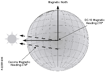
Since the heading of the Cessna to the Sun was 274 degrees it was greater than the 270‑degree heading of the DC‑10, that meant that the Cessna was south of the DC‑10 as shown in Figure 20.
PS. I can already feel that I may regret posting this.
Originally Posted by DGAC
Likewise, Sorry Hoodie.

Originally Posted by DGAC
But it's such a good story that it's well worth repeating 
PS You'll note that I am artfully avoiding an attempt at answering forget's question.
Forget, forgotten it`s S Hemisphere ?Sun is always to your `North`.....
Join Date: May 2008
Location: Alabama Gulf Coast via Grantham Lincs
Posts: 58
Likes: 0
Received 0 Likes
on
0 Posts
This part of the story doesn't make sense to me...............
"The Cessna landed safely after being airborne 23 hours and 5 minutes arriving at close to midnight 8 hours beyond its 1600 ETA. Prochnow had stretched the Cessna�s twenty-two hours of fuel by 5 percent through cruise control."
A Cessna 188 Agwagon wouldn't have fuel for that long in the air unless it was carrying extra tanks where it would normally carry it's agricultural load.
Anyone know if the Cessna had some kind of tanks for ferrying?
Join Date: Jul 1999
Location: 58-33N. 00-18W. Peterborough UK
Posts: 3,040
Likes: 0
Received 0 Likes
on
0 Posts
This is what's bothering me. I thought that, for all practical purposes and because of the sun's size and distance from Earth, light rays reaching the Earth are parallel. So, at any instant, it doesn't matter where you are on Earth the (true) heading to the sun is the same.
Like I said, I know I'll regret asking this.
PS.
Not if it's southern summer it ain't. Tropic of Capricorn?
The Tropic of Capricorn lies 23� 26′ 16″ south of the Equator. It marks the most southerly latitude at which the sun can appear directly overhead at noon. This event occurs at the December solstice, when the southern hemisphere is tilted towards the sun to its maximum extent.
Like I said, I know I'll regret asking this.
PS.
Sycamore, Southern Hemisphere? Sun is always to your `North`.....
The Tropic of Capricorn lies 23� 26′ 16″ south of the Equator. It marks the most southerly latitude at which the sun can appear directly overhead at noon. This event occurs at the December solstice, when the southern hemisphere is tilted towards the sun to its maximum extent.
Last edited by forget; 13th Aug 2010 at 11:01.
Join Date: Jul 1999
Location: 58-33N. 00-18W. Peterborough UK
Posts: 3,040
Likes: 0
Received 0 Likes
on
0 Posts
No navigators here? I got the words below from a sunset/sunrise primer. It says the same as I'm trying to say; Figure above can't work. I'd like to be shown I'm wrong.
The Azimuth of sunrise/sunset is the compass bearing. North is 0�, East is 90�, etc. On the equinox (approx March 21st/September 21st), the sun rises due east and sets due west (all over the world). At other times, the sun rises north or south of due east.
The Azimuth of sunrise/sunset is the compass bearing. North is 0�, East is 90�, etc. On the equinox (approx March 21st/September 21st), the sun rises due east and sets due west (all over the world). At other times, the sun rises north or south of due east.
Join Date: Nov 2007
Location: New Zealand
Age: 77
Posts: 519
Likes: 0
Received 0 Likes
on
0 Posts
In the same part of the world and a few years later a ferry pilot in a small aircraft was heading south towards Pago Pago (which is where the other aircraft being discussed had taken off from) but he never found the island and continued on until he was able to contact me at Niue (I dont recall exactly but I think that must have been on VHF). He could not find Niue and of course we had nothing on the ground to help him. Eventually he said he would be ditching while the engine was still running and he still had some daylight. He also said that if he managed to get into his life raft he would turn on his EPIRB at sunrise.
A RNZAF P2 went up from NZ and was in the general area are sunrise when the beacon came on and he was located in a very short time. He was not much further than over the horizon from Niue, maybe 60 miles I forget exactly, be we had no boats able to navigate out of sight of land and there was no commercial shipping located in the area by the Orion. It was arranged by the RCC that a Coast Guard cutter from Pago Pago would go and pick him up but they left without return fuel arranging instead that a tug would follow along behind with more fuel, however the tug returned to Pago Pago for some reason and of course the cutter was left helpless in the South Pacific but with the pilot on board. After a week or so the Orion was back in the area searching for the cutter!
I cannot swear to the accuracy of the bits of this story which did not immediately involve me but I believe it is essentially correct.