


Qantas Crew Help Lost Pilot in the 1950/60s

Join Date: Nov 2007
Location: New Zealand
Age: 77
Posts: 519
Likes: 0
Received 0 Likes
on
0 Posts
Regarding sun azimuth, yes that would be right. The azimuth of sunset would give you an idea of latitude and comparing the time of sunset would give you an indication of relative longitude. Altitude of the two aircraft would play a part and maybe the Air NZ crew were able to calculate that in.


Join Date: Jul 1999
Location: 58-33N. 00-18W. Peterborough UK
Posts: 3,040
Likes: 0
Received 0 Likes
on
0 Posts
Brian, I've got it, I think. What threw me was the sequence of events, as written. I thought that the Cessna being South of the DC-10 was determined on the magnetric headings only, which isn't possible. (Is it  ) If the events are reversed, sun elevation first, then heading, it's obvious - sort of.
Like I said, I knew I'd regret asking. Brilliant bit of work though - bl**dy genius.
) If the events are reversed, sun elevation first, then heading, it's obvious - sort of. Like I said, I knew I'd regret asking. Brilliant bit of work though - bl**dy genius.
Captain Vette, a qualified navigator, contacted Prochnow and asked him to head toward the Sun and to report his magnetic heading. Prochnow pointed the Cessna to magnetic heading 274 degrees as Vette steered his DC-10 toward the Sun and read his magnetic heading as 270 degrees. Next Vette instructed Prochnow to determine the elevation angle of the Sun above the horizon using his partially outstretched arm and fingers as a sextant. Prochnow established the elevation of the Sun as four fingers as Vette measured the elevation of the Sun as two fingers.
Join Date: Aug 2003
Location: Sale, Australia
Age: 80
Posts: 3,832
Likes: 0
Received 0 Likes
on
0 Posts
Just to make sure you got it  Say the sun was directly overhead the equator at the 0� meridian. To an observer on the equator at 90�E or W, or at either of the poles, the sun would be on the horizon (assuming perfect sphere, no refraction etc etc). To each of the four observers the suns azimuth would be,
South Pole - 000�T
North Pole - 180�T
90�E - 270�T
90�W - 090�T
Each of the four positions lie on a circle, centred at the suns position, of radius 5400NM (assuming 1�=60NM). As the suns altitude increases, as observed by the observer, the radius of the LOP decreases. No matter the radius, unless it's zero, somewhere on the LOP circle the azimuth of the sun will run the full gamut of 360�.
A navigator can even use the sight to determine his compass error.
Had to get out D. C. T. Bennetts "Complete Air Navigator" to make sure I got it as well.
Say the sun was directly overhead the equator at the 0� meridian. To an observer on the equator at 90�E or W, or at either of the poles, the sun would be on the horizon (assuming perfect sphere, no refraction etc etc). To each of the four observers the suns azimuth would be,South Pole - 000�T
North Pole - 180�T
90�E - 270�T
90�W - 090�T
Each of the four positions lie on a circle, centred at the suns position, of radius 5400NM (assuming 1�=60NM). As the suns altitude increases, as observed by the observer, the radius of the LOP decreases. No matter the radius, unless it's zero, somewhere on the LOP circle the azimuth of the sun will run the full gamut of 360�.
A navigator can even use the sight to determine his compass error.
Had to get out D. C. T. Bennetts "Complete Air Navigator" to make sure I got it as well.
BA, I used a couple of sites,`gaisma.com`,and the NOAA site to sort out sunsets ,azimuths ,and back timed the variation. The link to the story is a little short on detail,ie what time was the Mayday made, and so on. Another curiosity is that it was picked up by Auckland,so presumably on HF ,as Jay was out of range from NI.Later it says that an HF position line was obtained by the DC10 to confirm position(line). I would have thought that it could have been earlier . I recall reading the full article in the early 80s ,which I`m sure had a lot more detail....Anyway all the more reason to make sure your Standby compass is swung accurately...not sure if an AgWagon would have a full system....
Nevertheless,a truly outstanding bit of flying ,and navigating,by both parties,so never go with fuel left in the bowser....
Nevertheless,a truly outstanding bit of flying ,and navigating,by both parties,so never go with fuel left in the bowser....
Join Date: Nov 2007
Location: New Zealand
Age: 77
Posts: 519
Likes: 0
Received 0 Likes
on
0 Posts
I have often wondered if anyone tried to predict the position of the Cessna by using known winds. At least one report said the pilot had not deviated from his planned heading but had missed Norfolk Island due to the winds not being as forcast, therefore someone who later knew the actual winds shoud have been able to predict the position of the Cessna.
Whatever, for all I know Captain Vette may have included that anyway.
Whatever, for all I know Captain Vette may have included that anyway.
Join Date: Jul 2008
Location: adelaide australia
Posts: 272
Likes: 0
Received 0 Likes
on
0 Posts
now if someone would be so kind as to explain how he used the radio reception to find the longitude, i would be thankful.
from the diagram in the story i would have though that the reception would be lost on the opposite side of the box, not the side it shows the lost aircraft was closest to?
from the diagram in the story i would have though that the reception would be lost on the opposite side of the box, not the side it shows the lost aircraft was closest to?
Join Date: Jul 1999
Location: 58-33N. 00-18W. Peterborough UK
Posts: 3,040
Likes: 0
Received 0 Likes
on
0 Posts
From the diagram in the story I would have though that the reception would be lost on the opposite side of the box, not the side it shows the lost aircraft was closest to?
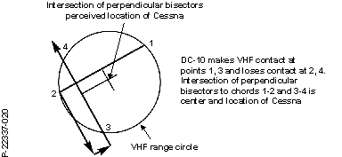
At Point 1 reception of VHF by the DC-10 begins to increase, from nothing. At Point 2 it decreases to nothing. From this, the Cessna is abeam track 1-2, half way between 1 and 2, but it can be to the North of 1-2, or the South.
The DC-10 then turns left at Point 2 and then does a 180 after which the VHF signal starts to increase from nothing at Point 3. At Point 4 the signal decreases to nothing. From this, the Cessna is abeam track 3-4 and half way between 3 and 4, thus resolving the question, North or South of track 1-2.
Had the Cessna been North of 1-2 then the circle simply shifts North West.
(Note that initial aircraft/aircraft calls would have been by long range HF radio, but no mention is made of this. Note also the comment, 'VHF Aural boxing depends on continuous transmission on VHF otherwise a silence can be construed as loss of contact'. The Cessna would almost certainly have been fitted with ARC VHFs. I wouldn't trust one to provide a continous transmission for that period, it'd burn out and I'll bet the Cessna pilot knew that too. Transmission bursts are more likely.)
Join Date: Jul 1999
Location: 58-33N. 00-18W. Peterborough UK
Posts: 3,040
Likes: 0
Received 0 Likes
on
0 Posts
PS. I've just remembered. Not long after Vette's save Air New Zealand, and I think QANTAS, installed electrical meters at Flight Engineers' stations. These meters were connected to the Automatic Gain Control test output of a VHF transceiver. The higher the reading the stronger the received signal; accurate, and great for radio locating. I wonder if they were ever used.
Join Date: Jun 2003
Location: Australia
Posts: 469
Likes: 0
Received 0 Likes
on
0 Posts
Forget
Yes they were known as search meters and were in fact a signal strength meter and were normally operated by the FE.When plugged in to (I think) VHF#1, the gain was automatically increased.Strange setup because we monitored "guard " on VHF #3.
Personally I've used them about 5 times in anger and we found 3 downed aircraft, including 1 fatal in the Blue Mountains near Sydney.In most cases we were steered into the search site by ATC.
When Qantas was privatised the management decided to remove them.
Additionally to all the above mentioned lost aircraft, I seem to remember a ferry aircraft going down near Tahiti. The Qantas crew were talking to him all the way down and he was never heard of again. From memory the Captain of the Qantas aircraft was Ben S.
Wunwing
Join Date: Jul 1999
Location: 58-33N. 00-18W. Peterborough UK
Posts: 3,040
Likes: 0
Received 0 Likes
on
0 Posts
Which reminds me, in the '70s a transatlantic flight picked up a 121.5 ELT signal, mid ocean. Either Shannon or Gander asked all flights to monitor 121.5 and to report their INS positions when the signal was first heard and when it was lost. After a couple of hours they had several dozen plots and were able to divert a Shell tanker to a spot in the Atlantic. The tanker found a lone yachtsman with a broken mast. If I remember rightly a Concorde was even more involved in the airborne plot production - anyone?
