


Four Course Radio Range


Join Date: Oct 2000
Location: Bristol
Posts: 461
Likes: 0
Received 0 Likes
on
0 Posts
At Claresholm, in the lee of the Rockies, where the wind could be blowing down all three runways at the same time, the castoring tailwheel of the Mk 2's was bad, man, bad. I have seen several Harvards on their noses at the same time, with the Crash Crew going from one to the other in strict order of occurance.
For the financially minded, we were allowed to write off the value of one Harvard, either all at once or in bits and pieces, and then we were chopped.
Dick
For the financially minded, we were allowed to write off the value of one Harvard, either all at once or in bits and pieces, and then we were chopped.
Dick
Join Date: Mar 2000
Location: Arizona USA
Posts: 8,571
Likes: 0
Received 0 Likes
on
0 Posts
Watched a Harvard pilot land his newly restored airplane a few years ago...quartering tailwind, ground looped.
A mess.
Found out later he was a current DC-10 Captain...and was looking for the autopilot autoland lever.
Airplane towed off to his hangar to have the dents pounded out, and the engine/prop overhauled..
A expensive proposition, to be sure.
A mess.
Found out later he was a current DC-10 Captain...and was looking for the autopilot autoland lever.
Airplane towed off to his hangar to have the dents pounded out, and the engine/prop overhauled..
A expensive proposition, to be sure.
I'll go have another look for my procedures book on the range lost orientation. I went looking this AM and couldn't find it.
We also had an ILS lost orientation, in which you had to figure out whether you were on a front course or a back course. I only ever did it once, in practice. You had to position the aircraft to cross the ILS at 90 degrees, and time the full deflection of the localizer needle, call that A to B. You then either turned left or right 135 degrees to recross the localizer and then turned either left or right to cross the localizer again at 90 degrees on the same heading as the first time you crossed and timed that full deflection, call that C to D. If you'd turned left for the 135 degree turn and the timing was greater C to D than it was A to B, you were on a back course, and vice versa. I never really did figure out why that procedure was necessary, but back then most ILS recievers had five channels, A, B, C, D and E and were only crystal tunable. We had one DC-3 freighter that they eventually forbade us to fly into YUL because we didn't have frequency 110.5, the freek on R24L at the time.
We also had an ILS lost orientation, in which you had to figure out whether you were on a front course or a back course. I only ever did it once, in practice. You had to position the aircraft to cross the ILS at 90 degrees, and time the full deflection of the localizer needle, call that A to B. You then either turned left or right 135 degrees to recross the localizer and then turned either left or right to cross the localizer again at 90 degrees on the same heading as the first time you crossed and timed that full deflection, call that C to D. If you'd turned left for the 135 degree turn and the timing was greater C to D than it was A to B, you were on a back course, and vice versa. I never really did figure out why that procedure was necessary, but back then most ILS recievers had five channels, A, B, C, D and E and were only crystal tunable. We had one DC-3 freighter that they eventually forbade us to fly into YUL because we didn't have frequency 110.5, the freek on R24L at the time.

Join Date: Jul 2007
Location: France
Posts: 610
Likes: 0
Received 0 Likes
on
0 Posts
Orientation
pigboat:
I have some old information on orientation from an unknown position for the DME that includes homing and rate of closure. Also some charts on the Australian Visual Aural Range system from the old days.
Let me know if you are interested.
Tmb
I have some old information on orientation from an unknown position for the DME that includes homing and rate of closure. Also some charts on the Australian Visual Aural Range system from the old days.
Let me know if you are interested.
Tmb
Guest
Posts: n/a
Check with the CAF in Midland, TX. They have a recording of the As and Ns in their hangar.
Official Home Page of the Commemorative Air Force
Official Home Page of the Commemorative Air Force
Couple of comments/inputs -
Frankly, I thought the RR/Cone of Silence sequence in the Film of the same name quite descriptive, including a visual training chart that could be clearly seen. Plus, the aural morse A's and N's could be clearly heard, as well as their fading out into the cone.
There is an excellent freeware add-on scenery package to Microsoft FS2004, called Radio Range v4 which implements both RR airways and approaches over the whole of North America. It includes 'updated' DC-3's also, the ability to insert 'RR' radios into other FS aircraft. Also, there is comprehensive documentation covering instructions, charts and approach plates.

Join Date: Feb 2009
Location: Plainfield Indiana
Age: 53
Posts: 1
Likes: 0
Received 0 Likes
on
0 Posts
Dont know if this will help...
While searching through Indiana Universities online catalog I came across this 1949 chart for an A/N station approach to Stout Field (abandoned) in Indianapolis Indiana:


I was actually able to locate the original site on Terraserver USA and Google Earth.


The towers measured 300ft radius from the center tower, 600 ft diameter according to Google Earth. Hope this helps.
I was actually able to locate the original site on Terraserver USA and Google Earth.
The towers measured 300ft radius from the center tower, 600 ft diameter according to Google Earth. Hope this helps.
Join Date: Aug 2006
Location: Timbukthree
Posts: 13
Likes: 0
Received 0 Likes
on
0 Posts
Last time I saw a "Lost Range Orientation" was in Watson Lake, Yukon.
Anyway, here is more theory: http://www.aerofiles.com/adcock-range.html
Anyway, here is more theory: http://www.aerofiles.com/adcock-range.html
Join Date: Aug 2011
Location: Ohio
Posts: 1
Likes: 0
Received 0 Likes
on
0 Posts
low frequency radio range charts
I am writing a memoir of my aviation career, need a high-quality image of a LFR approach procedure. May I have your permission to reproduce the Fort Chimo approach plate in the PPRuNe Forums?
Thank you,
R. L. Taylor
Thank you,
R. L. Taylor
Join Date: Jul 2007
Location: France
Posts: 610
Likes: 0
Received 0 Likes
on
0 Posts
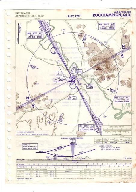
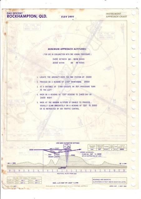
1960's Visual Aural Approach Rockhampton Australia
Pigboat:
With reference to post # 27 above here is the VAR approach chart and the DME Descent chart.
Hope this info is of interest.
Tmb
With reference to post # 27 above here is the VAR approach chart and the DME Descent chart.
Hope this info is of interest.
Tmb
Hi all,
Why not contact the Flying Boat Museum in Foynes, Limerick, Ireland? I know of one pub in the area which has colour plates of that kind on the walls.
regards
TDD
Why not contact the Flying Boat Museum in Foynes, Limerick, Ireland? I know of one pub in the area which has colour plates of that kind on the walls.
regards
TDD
Join Date: Sep 2000
Location: Bendigo, Australia
Age: 76
Posts: 97
Likes: 0
Received 0 Likes
on
0 Posts
Orientation
It was quite logical.....
If you note on Tmbstory's post #33, the Rockhampton visual range (which was usual the major route/runway heaading) was labelled Blue/Yellow and (from memory) the cockpit display was Yellow(left)/Blue(right) with the needle indicating which sector you were presently occupying.
(The cockpit indicator was NOT orientated to the direction you were heading, only the sector you occupied)
On the Rockhampton chart, the Blue sector is to the WESTERN side of the VAR, Yellow to the EASTERN sector.
Using the Rocky chart, if you were to the SouthWest of the VAR, the Visual indicator would indicate Blue, the Aural would be 'A'.
Tracking Northwest and crossing the Aural range the tone would change from 'dit-dah' to 'dah-dit' but when both tones were synchronised/Null'd - just the 'Oboe' sound.
From this position (not knowing how far abeam the VAR station you were) the turn would be right onto 033 plus 45/60 to re-intercept the Aural null, thence tracking 033 to the VAR. Station passage would be indicated by the needle changing from BLUE sector to YELLOW sector. (Right to Left)
To make the VAR approach, a right turn into the 'A' /YELLOW sector (the needle is in the LHS Yellow Indication) outbound 147 for one minute, turn inbound to intercept the Blue/Yellow visual range 327 track (needle moving Left to Right/centre as you turn right). Station passage is the Aural null and thence timing outbound for the VAR approach.
At the Time Indicated outbound, procedure turn to the left into the Blue sector (needle moving Right), thence needle moving Left as you turn Right to intercept 147........
On the approach, the needle will indicate which sector you are moving into (Yellow left/ Blue Right).
(Remember the Yellow/Blue Orientation of the cockpit display only indicates the colour sector, not the orientation)
Fun stuff!
The Aural Legs were often not perpendicular to the BLUE/YELLOW track, usually aligned with another route (and not always 180 opposed as shown on the Rocky chart).
The orientation procedure is how I remember it from 1973 using the Nhill (Aust) VAR. the last VAR was at Devonport Tasmania and that was replaced by the VOR in about 1979.
Audio Simulation
That is quite a nice simulation of radio range audio here: Low-frequency radio range - Wikipedia, the free encyclopedia
Join Date: Jul 2007
Location: France
Posts: 610
Likes: 0
Received 0 Likes
on
0 Posts
Orientation VAR
Derated:
Thanks for the good post #35.
When I was taught the VAR in the early days, on the eastern coast of Australia, the Blue and Yellow were called the Blue Mountains and the Yellow seas or sands of the Coast. The "N's" were North and Northwest and the "A's"below that in the South West and South East sector.
It did help us with orientation.
Tmb
I can't copy the link (stupid iPad keeps opening the YouTube viewer) but some guys built their own four course range in Tennessee. Do a search on YouTube for "four course range." And try to ignore the twerp flying the plane.
I though the last AN range approach was in Mexico. I've got a chart for Chihuahua with a revision date of 1985 or 86.
I though the last AN range approach was in Mexico. I've got a chart for Chihuahua with a revision date of 1985 or 86.
Last edited by MarkerInbound; 29th Aug 2011 at 12:11.
