


Which Aerodrome?

Join Date: Mar 2001
Location: Wet Coast
Posts: 2,335
Likes: 0
Received 0 Likes
on
0 Posts
Not a minibus Jenkins, that's how big (small) a normal single-deck bus was back then. Although it doesn't look really ancient, immediate post-war period perhaps. Not a Bedford OB, some kind of Commer maybe. If that helps  .
.
.

Join Date: Jan 2007
Location: Either somewhere in the 3rd world, the land of cheese and wine, or possibly very occasionally, at home.
Age: 59
Posts: 488
Received 0 Likes
on
0 Posts
Bluddy hell thats changed a bit! I used to live near there, and wouldn't recognise it in a million years from that picture") All housing estates and chavs there now- certainly don't leave your car unlocked if you want to snap a pic of the airfield now
All housing estates and chavs there now- certainly don't leave your car unlocked if you want to snap a pic of the airfield now
Still a fair bit of it remaining last time I was there. We used to use it to test inflate balloons when Ashton Court was too wet in the winter when I worked for Cameron Balloons- bit too exposed though...
Still a fair bit of it remaining last time I was there. We used to use it to test inflate balloons when Ashton Court was too wet in the winter when I worked for Cameron Balloons- bit too exposed though...
Nice picture, Bri. No rain and low clouds, for a change!
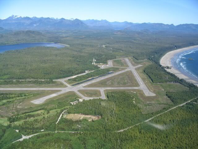
Tofino in the Pacific Rim National Park, Vancouver Island. Flew in there once in a BC Airlines Mallard.
Tofino in the Pacific Rim National Park, Vancouver Island. Flew in there once in a BC Airlines Mallard.
Last edited by India Four Two; 24th May 2008 at 19:19.

 . Tofino was established during WW.II as a coastal patrol base. You have control.
Another maritime airfield on a much smaller island:

Sorry about the poor resolution. The original image was quite small and I had to crop it to remove some obvious clues. It's the only picture I could find of this very interesting airfield, which I first noticed on Google Earth.
Sorry about the poor resolution. The original image was quite small and I had to crop it to remove some obvious clues. It's the only picture I could find of this very interesting airfield, which I first noticed on Google Earth.
Here are the first two clues.
1. It is 18 nm from one of the world's top twenty busiest airports.
2. It has a hard surfaced runway, but it does not appear on the World Aeronautical Chart.
1. It is 18 nm from one of the world's top twenty busiest airports.
2. It has a hard surfaced runway, but it does not appear on the World Aeronautical Chart.
C2j, that's the one - Pulau Sudong http://en.wikipedia.org/wiki/Pulau_Sudong
I figured you might get it. You must have flown past it quite frequently.
Here's the original image with the RSAF Black Knights aerobatic team (Red and White Knights would be a better name):

and here's an image from Google Earth:

It still amazes me that there are five (six if you count Pulau Sudong) operational airfields on an island that is only 80% larger than the Isle of Wight. And just for insurance purposes, there is the emergency runway on the East Coast Parkway near Changi.
C2j, I was surprised that Pulau Sudong is not on the WAC. Does it show on the Jeppesen charts?
I42
I figured you might get it. You must have flown past it quite frequently.
Here's the original image with the RSAF Black Knights aerobatic team (Red and White Knights would be a better name):
and here's an image from Google Earth:
It still amazes me that there are five (six if you count Pulau Sudong) operational airfields on an island that is only 80% larger than the Isle of Wight. And just for insurance purposes, there is the emergency runway on the East Coast Parkway near Changi.
C2j, I was surprised that Pulau Sudong is not on the WAC. Does it show on the Jeppesen charts?
I42
Join Date: Jul 2007
Location: Charlotte, NC USA
Age: 64
Posts: 508
Likes: 0
Received 0 Likes
on
0 Posts
India Four Two,
You forgot the emergency runway next to Tengah AND the additional (new) runway next to Changi which is military and NOT connected to the main airport. The RSAF actually uses the road next to Tengah once a year in a practice. The runway that is part of the East Coast Parkway near Changi has never been used to my knowledge.
I don't have a Jepp area chart at hand so cannot say it the runway is depicted on it. The commercially available ONC chart (VFR) that includes Singapore is grossly out of date (like 1973). My understanding is that updates for these U.S. Government printed charts sometimes are not done at the request of the underlying country (countries). A bit silly when we now have Google Earth (though some of that is not high-res for similar reasons).
So, here is the next "Which Aerodrome". If this isn't identified wihtin an hour, all regular participants have to miss a turn!
C2j
You forgot the emergency runway next to Tengah AND the additional (new) runway next to Changi which is military and NOT connected to the main airport. The RSAF actually uses the road next to Tengah once a year in a practice. The runway that is part of the East Coast Parkway near Changi has never been used to my knowledge.
I think you are right about the ECP runway. Apart from bulldozing out of the way all of the concrete flower boxes in the median , a lot of tree-cutting would be required, so I think it would have to be a very serious situation before it was used.
I downloaded the WAC from the CAAS website, so I presume it is relatively up to date (I don't have access to it as I type this). However, Pulau Sudong is not referred to in the AIM, but all the other military fields are. Very strange.
So, here is the next "Which Aerodrome". If this isn't identified wihtin an hour, all regular participants have to miss a turn!
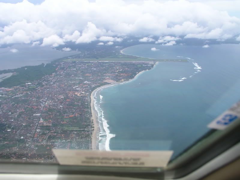
I thought initially Phuket, but after a bit of searching and head-scratching, I remembered Bali. It's Ngurah Rai International from overhead Kuta. Open house if correct.