


length of the nautical nile


Joined: Mar 2011
Posts: 81
Likes: 0
From: outside the box
I think there is something in what you said Shabez, about geocentric and geodesic you mentioned in your first post.. 
I m not an expert but I think I ve got some ideas..
First the Geodesic.
I dont really like abstract thinking so i thought visualising is maybe the best way to answer this kind of questions..
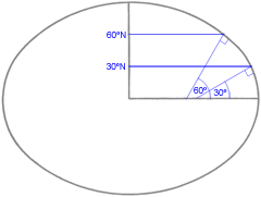
In the picture above we se the geodesic system we are currently using to find our coordinates around the earth (the flattened by 0.3% oblate ellipsoid).. If we simply look att the 60 deg angle, we know that from that point and ''straight'' down to the equator fitts 60x60 Nautical miles so that only leaves us with 30x60 NM from that point up to the pole.. which in this picture (kind of exaggerated) seems to be a much longer distance.. I think this clearly answers your question Shabez!!
The other picture is a mix of Geocentric and Geodesic.

The geocentric angle is ψ and the geodesic angle is φ. Its kind of interesting i think to see that the geocentric system has an opposite effect. The angle ψ seems to be something like 45deg (appr) and if you look carefully you can se that the distance from that point to the equator is longer than to the pole. (I could clearly see that when I drew an ellipse with increased ecentricity)..
So my conclusion..
Geodesic system: Longer NM close to the poles
Geocentric system: Longer NM close to the equator
Please reflect to these and post your thoughts , because as i said im not an expert in these matters!!
regards
Jetpipe.
I m not an expert but I think I ve got some ideas..
First the Geodesic.
I dont really like abstract thinking so i thought visualising is maybe the best way to answer this kind of questions..
In the picture above we se the geodesic system we are currently using to find our coordinates around the earth (the flattened by 0.3% oblate ellipsoid).. If we simply look att the 60 deg angle, we know that from that point and ''straight'' down to the equator fitts 60x60 Nautical miles so that only leaves us with 30x60 NM from that point up to the pole.. which in this picture (kind of exaggerated) seems to be a much longer distance.. I think this clearly answers your question Shabez!!
The other picture is a mix of Geocentric and Geodesic.
The geocentric angle is ψ and the geodesic angle is φ. Its kind of interesting i think to see that the geocentric system has an opposite effect. The angle ψ seems to be something like 45deg (appr) and if you look carefully you can se that the distance from that point to the equator is longer than to the pole. (I could clearly see that when I drew an ellipse with increased ecentricity)..
So my conclusion..
Geodesic system: Longer NM close to the poles
Geocentric system: Longer NM close to the equator
Please reflect to these and post your thoughts , because as i said im not an expert in these matters!!
regards
Jetpipe.
Guest
Joined: Apr 2009
Posts: 3,336
Likes: 0
From: On the Beach
Jetpipe:
The numerical value used for a nautical mile for critical procedure design is the value used, regardless of theory about the shape of the Earth.
And, the distances involved are small from a global (bad pun) standpoint.
The numerical value used for a nautical mile for critical procedure design is the value used, regardless of theory about the shape of the Earth.
And, the distances involved are small from a global (bad pun) standpoint.
Joined: Mar 2011
Posts: 1,407
Likes: 0
From: engineer at large
I am not sure where or why this thread is trying to illustrate.
Currently, I use the model expressed in the FMS..."right" or "wrong", that is what the aircraft is using. The FAA can come up with calcs to 12 sig digits, but if the FMS disco's...well....
While the FAA's calcs work in a straight line, the calcs do not work in a curve...(ie TARGETS busts)
Currently, I use the model expressed in the FMS..."right" or "wrong", that is what the aircraft is using. The FAA can come up with calcs to 12 sig digits, but if the FMS disco's...well....
While the FAA's calcs work in a straight line, the calcs do not work in a curve...(ie TARGETS busts)
Nemo Me Impune Lacessit
Joined: Jun 2004
Posts: 4,103
Likes: 5
From: Chabanais, France
Aristo Aviate 617
Made Avigation correspondence course and the exams a lot easier just by having that cursor on the front. Still got mine some forty six years later!
(6080 will do for me, the difference is less than the thickness of a Navigators pencil!).

Joined: Feb 1998
Aviation Qualifications: ATPL
Posts: 1,595
Likes: 0
From: Formerly of Nam
Yep I only got as far as the oblate spheriod, which the ATPL
Nav lecturer described as what a 2yo would produce if you
gave him a lump of plasticine and asked him to roll it into a
nice smooth ball.
I'm a product of the 6,080ft generation but was changed to
6076.11ft when I went P-RNAV.
Nav lecturer described as what a 2yo would produce if you
gave him a lump of plasticine and asked him to roll it into a
nice smooth ball.
I'm a product of the 6,080ft generation but was changed to
6076.11ft when I went P-RNAV.
Joined: Jan 2011
Posts: 217
Likes: 0
From: on the cusp
I am not sure where or why this thread is trying to illustrate
The "international nautical mile" was fixed at 1852m many years ago. But even after that both the US and the British continued with their own defintions. Prior to that there were many definitions, all based on countries own navigation needs, and the datums they had adopted for charting. But all were based on an approximation of one minute of arc of a meridian. The basis for this measurement is based on charting. If you travel due north and gained one minute of latitude in one hour, then you had travelled one nautical mile.
The numerical value used for a nautical mile for critical procedure design is the value used, regardless of theory about the shape of the Earth.
And, the distances involved are small from a global (bad pun) standpoint.
And, the distances involved are small from a global (bad pun) standpoint.
Ultimately there are many definitions of a "mile" all of which are convenient for their own calculations, including geographic mile, tactical mile, statute mile, and the list goes on.
As for using an FMS, someone has already (hopefully) calculated all these variations.
Joined: Feb 2009
Posts: 354
Likes: 0
From: Jungles of SW London
Oooo my 'ead 'urts!  I wish I hadn't started reading this thread, but I simply couldn't stop myself.
  My late dad was a navigator, by all accounts a very good one and he would have loved this thread.
I have always been comfortable teaching my Scouts how Latitude and Longitude work and how a nautical mile is a mathematical subdivision of a circle the diameter of the Earth and so on. This all leads naturally enough to the various grid systems in use, down to the beloved Ordnance Survey grid, which I am trying to teach them to understand and use.
But now I've read this thread and I find I am going to have to lie to my Scouts, because there is no way I'm going to explain this!
Nevertheless, even though my brains are now mush and I'm not sure whether to trust my hand held GPS any more, thanks to everyone who contributed to a very interesting thread and the links to pages of mind boggling information.
Roger.
I wish I hadn't started reading this thread, but I simply couldn't stop myself. My late dad was a navigator, by all accounts a very good one and he would have loved this thread.I have always been comfortable teaching my Scouts how Latitude and Longitude work and how a nautical mile is a mathematical subdivision of a circle the diameter of the Earth and so on. This all leads naturally enough to the various grid systems in use, down to the beloved Ordnance Survey grid, which I am trying to teach them to understand and use.
But now I've read this thread and I find I am going to have to lie to my Scouts, because there is no way I'm going to explain this!
Nevertheless, even though my brains are now mush and I'm not sure whether to trust my hand held GPS any more, thanks to everyone who contributed to a very interesting thread and the links to pages of mind boggling information.
Roger.

