A few enquiries about the fuel analysis.
The flightpath and fuel analysis is critical to finding MH370.
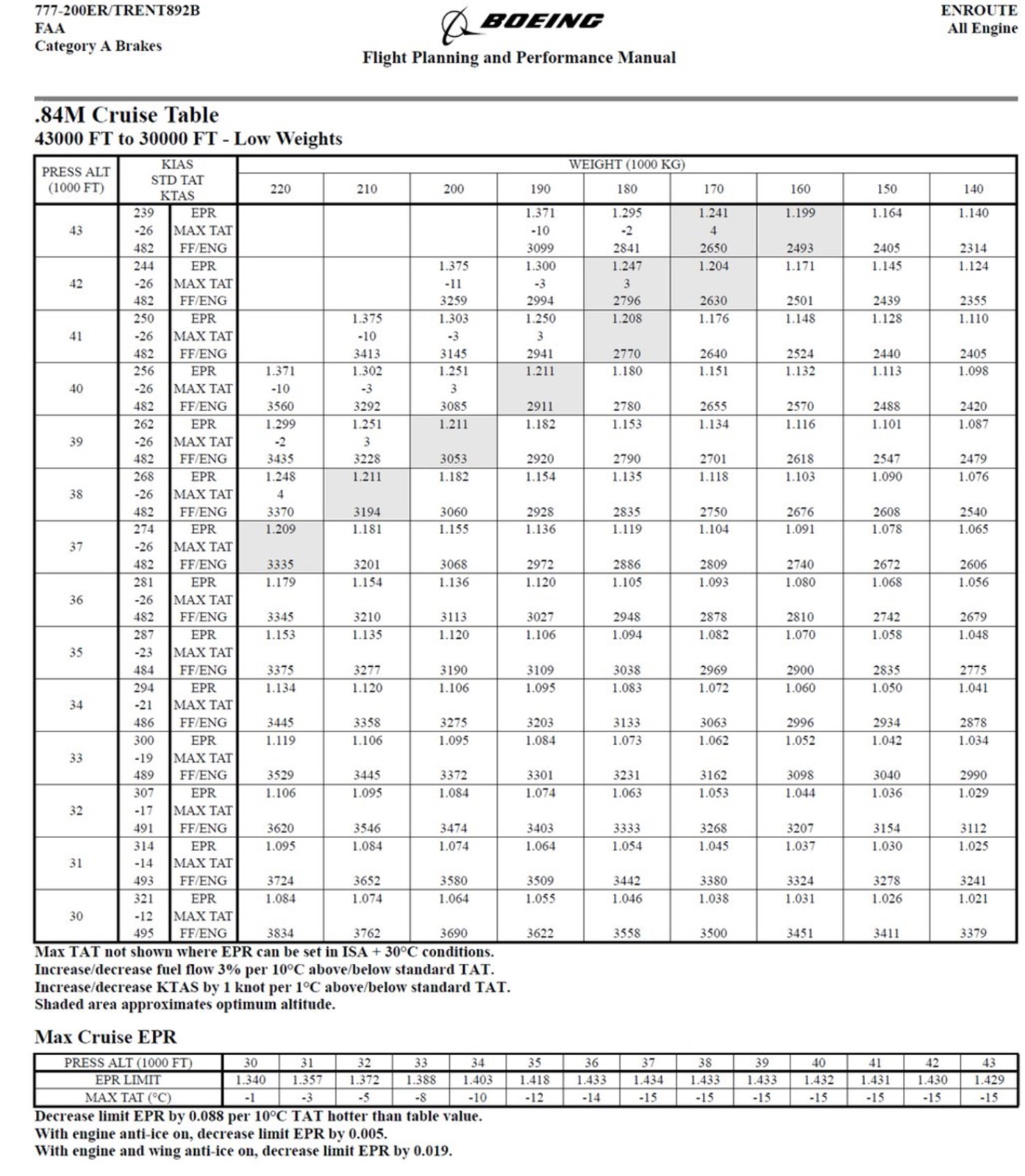
Based on the three fuel flow (FF) tables for the B777-200ER/Trent892B, namely the:
0.84 Mach Cruise Table,
Long Range Cruise Table,
Holding Flaps Up (less 5% for racetrack pattern),
we can obtain the fuel flow equation for each particular phase of flight to match radar, phone call and satellite data.
ie cruise to IGARI from last ACARS at FL350,
diversion from IGARI to TOPD Banda Aceh via south of Penang at FL340/0.84M,
ECON DESC 268KIAS at TOPD Banda Aceh VNAV ALT FL340 via NILAM-SANOB.
The FF FL340/0.84M equation (2 eng kg/hr) is easily obtained from the chart.
The FF for the other phases of flight requires vertical extraction for speed variation first eg for the flight at 268KIAS/FL340, the FF at a particular weight is corrected to the 268KIAS speed based on the 3 performance charts, then the equation calculated.
If W is the weight in 1000kg, then the 2 Eng fuel flow (FF) in ISA for
268KIAS FL340 = 0.0011246*W^3 - 0.5423*W^2 + 102.1268*W - 1913.15
Finally the actual FF is corrected for:
ISA deviation, +3% per 10C TAT
Aircraft PDA of +1.5% (Right +2.55, Left + 0.45%)
Bleed air status, OFF -2%
Turns +5% per 25 deg AoB
Thus, recreating the flight using recorded winds and temperatures (bleed air failed at IGARI, Left autothrottle inop, crew deceased at 1800Z), then the following critical position, time, left tank fuel quantity, right tank fuel quantity are obtained:
ACARS report (GW 218169kg) 5.289N102.803E, 1706:43, 21875, 21925
Transponder off/fail 6.931N103.591E, 1720:34, 21105, 21139
Start Turn back 7.039N103.756E, 1722:03, 21022, 21058
End Turn back 7.248N103.618E, 1724:50, 20869, 20892
FO phone connection 5.21N,100.295E, 1752:27, 19199, 19361
Last PSR 10NM NW MEKAR 6.577N96.342E, 1822:12, 17380, 17729
SATCOM logon Arc 1 6.731N95.956E, 1825:27, 17188, 17579
Left turn BFO 6.552N95.674E, 1828:06, 17026, 17467
Banda Aceh 5.523N95.422E, 1836:23, 16521, 17119
1st SATCOM Call 5.073N95.316E, 1839:59, 16302, 16968
Arc 2 2.586S93.427E, 1941:03, 12580, 14481
Arc 3 10.169S91.884E, 2041:05, 8923, 12157
Arc 4 17.849S90.703E, 2141:27, 5244, 9938
Arc 5 25.483S90.834E, 2241:22, 1592, 7860
Left Eng fail 28.823S91.419E, 2307:30, 0, 6996
2nd SATCOM Call 29.502S91.575E, 2314:03, 0, 6333
Arc 6 33.873S92.87E, 0011:00, 0, 750
Right Eng fail, 34.434S93.038E, 0018:44, 0, 0
Arc 7 Crash site ~34.4S93.0E, 0019:30, 0, 0
The flightpath meets the satellite data within 3 SD, PSR data, FO mobile phone logon, fuel on board, performance charts, autopilot constraints, MagVar2005, recorded GDAS wind/temperature history, barnacle analysis, drift analysis, debris damage analysis, simplicity of route, and is unsearched.