


What exactly is an altitude restriction (Jepp)?

Join Date: Dec 2021
Location: London
Posts: 55
Likes: 0
Received 0 Likes
on
0 Posts

Join Date: Jun 2007
Location: Wanderlust
Posts: 3,407
Likes: 0
Received 0 Likes
on
0 Posts
Vilas, that FAA doc is irrelevant. It's about missing stepdown fixes on the ILS when it's hot. Nothing to do with dodgy "do this but comply with that" type-instructions these guys got. What does "comply with the procedure" mean? The ILS, The STAR? The controller shouldn't have used those terms, the ILS AIP chart should have 7500 at DIXIR and Jeppesen, well, they can try to keep up please.
I think there are two separate issues here:
First, the direct clearance to the IAF and then for the ILS. If you are cleared for a �procedure�, ILS in this case, then respect published altitude and speed restrictions. Which is what they did. They were not cleared on any of the STARs, so restrictions on those do not apply - you have gone straight from en-route navigation to the approach phase under instruction from ATC. Given a clearance of this type, would you immediately think to question it, and if so, why, as it�s a pretty common thing to be instructed to do? In most countries, if there were intermediate ATC-desired restrictions, you would be asked to comply, such as �Cleared ILS 16C, maintain 4,000 or above until [waypoint]�. In any case, 6,000� at DIXIR is hardly in the weeds, and taking speed reduction into account looks not far off (as shown on the FMC snapshots above).
Second, and this is much more generic, it�s important to set effective bottom lines before events take over. If you are clear beforehand as a crew what you can and can�t accept in terms of safety/SOPs, then it saves having to puzzle it out on the fly in a high-workload scenario. Also, just because you�ve worked out the limit of what you can do doesn�t make it a target, just a backstop. You can set an MCP altitude constraint but stay way above it during a normal approach - it�s only there to protect you from descending below what Maverick would call your hard deck...

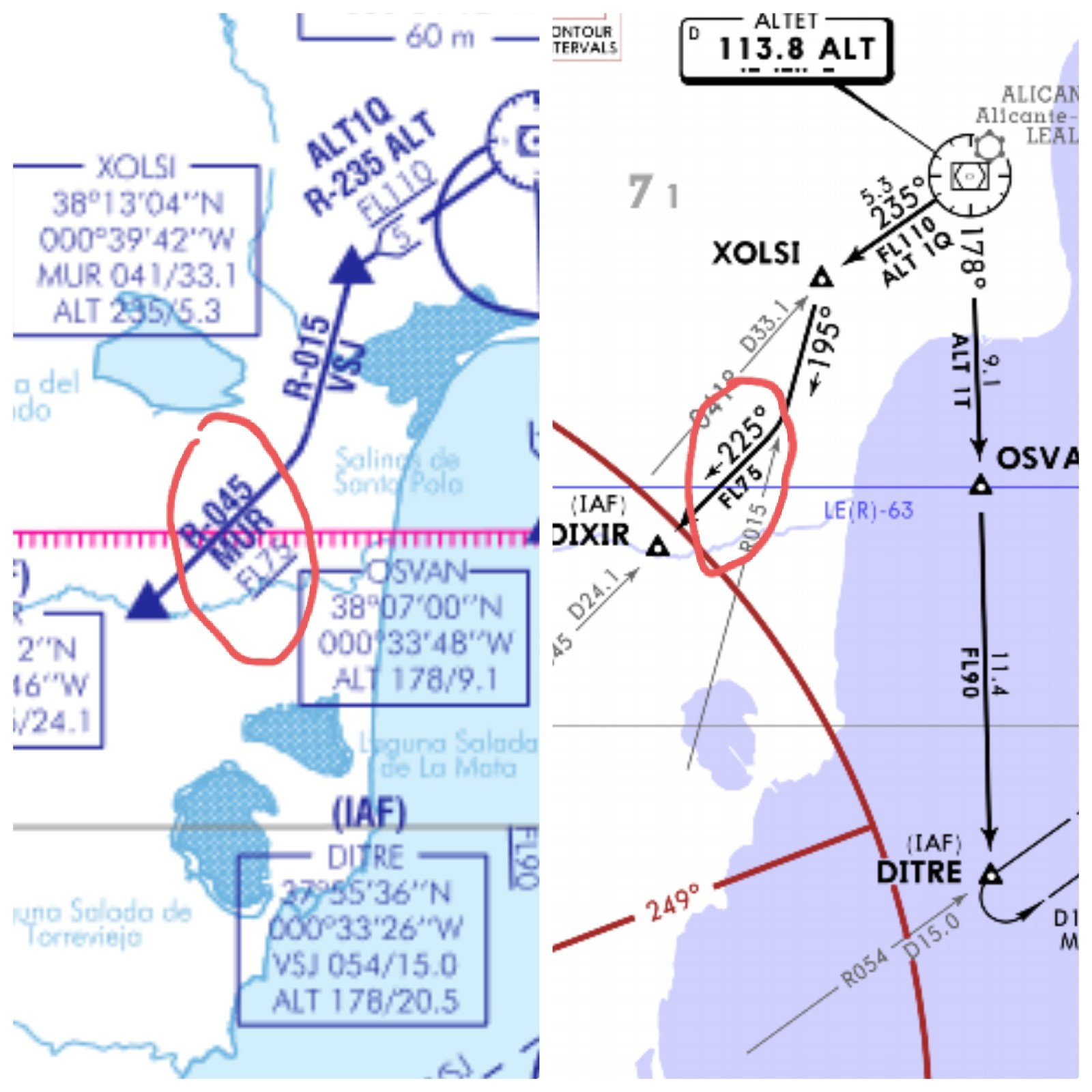
The ATC was referring to AIP (left) and you were flying Jepps (right).
I believe you are not the first nor the last, and suprised this hasn't been noticed by ATCs/Jepps since Jan 2019.

I believe you are not the first nor the last, and suprised this hasn't been noticed by ATCs/Jepps since Jan 2019.
The ATC was referring to AIP (left) and you were flying Jepps (right).
I believe you are not the first nor the last, and suprised this hasn't been noticed by ATCs/Jepps since Jan 2019.
I believe you are not the first nor the last, and suprised this hasn't been noticed by ATCs/Jepps since Jan 2019.
Join Date: Dec 2021
Location: London
Posts: 55
Likes: 0
Received 0 Likes
on
0 Posts
That’s interesting, and something they should fix, but it only applies if you were on a ALT1Q STAR. If you’d come in on a ALT1T, it’d be 4100 or above at DIXIT rather than FL75. On a direct routing to the IAF the constraints would be the ATC cleared level/altitude, restrictions on the ILS plate, what you thought was safe and sensible or a combination of these.
Was cleared direct to DIXIR descending to FL110 from a WPT 40-50nm North (prior to STAR). 10nm prior to DIXIR controller (no radar) instructed to "descend according to procedure" and cleared us for ILSRWY 23.
Last edited by common toad; 17th Oct 2022 at 11:16.
Originally Posted by Toad
"descend according to procedure"
The clearance was nonsensical, should have contained a limiting altitude, and the Jepp charts are inadequate/misleading. It's a worry that people can't see that. this is how accidents happen. Slack procedures and documentation that are tolerated until somebody gets caught out.
Thread Starter
Join Date: Apr 2013
Location: Neither here or there
Posts: 317
Likes: 0
Received 0 Likes
on
0 Posts
Thanks Capn Bloggs, nail on the head. Seems Common toad, and his type are not justifying their understanding of plates. This thread asked right at the beginning, "What exactly is an altitude/FL restriction?". Those claiming FL75 is the correct altitude at DIXIR have not answered that question. In the heat of the moment we didn't even notice the minimum flight level of FL75 between XOLSI and DIXIR probably due to our zoom settings and the fact we were on a direct. Full disclosure, I was commander of said flight. PF was was another Captain. We spoke about it afterwards but the honest truth is at that point neither of us even realised it until we were passing through 6000ft. So it wasn't a case of ignoring the so-called "restriction" or even that we had any doubt at that precise moment, it was more a case of confirmation bias given plate logic and what seemed sensible (no terrain and an ILS glidescope showing we needed to try a bit harder to get down). Southern Spain ATC are crap and need to adopt better clearances. Anyone flying to ALC or VLC lately might agree with me.
The ILS procedure starts at DIXIR at FL 075.
Given they were never on a STAR at all, why would they need to make any reference to it, any more than they�d need to use the NDB minima when cleared for an ILS?
The more I look at this, it�s ATCs problem. The clearance was unremarkable: direct to the IAF, further on the ILS procedure. Must happen around the World thousands, or tens of thousands times a day. Why would you question something routine and expected? No intermediate levels/altitudes were given, so go off the plate: the AIP ILS23 shows 4100 as the platform altitude but no higher restriction at DIXIR. The pilots flew a safe approach, ATC did not give any further restrictions, then expressed surprised when the pilots did what they had been cleared to do by ATC.
Join Date: Dec 2021
Location: London
Posts: 55
Likes: 0
Received 0 Likes
on
0 Posts
Surely you can see that is ambiguous?
Routing given is direct to DIXIR. The end of the STAR is FL 075, and though they have avoided the complete STAR, the level is relevant. Next instruction, �Cleared for the ILS, descend with the procedure�
Had the OP flown all of the STAR, and received the instruction, �Cleared for the ILS, descend with the procedure�, The next descent would start from DIXIR.
Had the OP had received �OXLSI dct DIXIR, cleared ILS, descend with the procedure� the descent from FL 075 would also have started from DIXIR.
Note that DIXIR is shown on the ILS chart - it�s part of the procedure. Why have Jepp not included a line from DIXIR or depicted descent? Because, I suggest, the chart is valid for two procedures- that from DIXIR, and that from the arc. To include that information would be very confusing indeed.
To answer the query from another, when to descent from FL 090 off the arc. If cleared for the ILS it would be when LLZ established.
Thread Starter
Join Date: Apr 2013
Location: Neither here or there
Posts: 317
Likes: 0
Received 0 Likes
on
0 Posts
Respectfully, I disagree. Above someone posted a snippet of VIBIM (for LEBL) clearly showing that the Spanish know full well how to convey an altitude/FL restriction. The route between XOLSI to DIXIR implies do not descend below FL75 between A and B. It's tempting to assume so, but it's not quite the same thing as a restriction at DIXIR! And above I have shown photos that it wasn't even coded like this in the box.
If the "restriction" was that important, why is it not shown like it is for VIBIM? Why confuse and ommit what would otherwise be a totally unambigious method of conveying the requirement? The fact we are having this conversation with a near 50/50 split in views shows they need to try harder to avoid ambiguity. I am trying to look for the legend used by Spanish AIP. Cannot find one. Anyone?
If the "restriction" was that important, why is it not shown like it is for VIBIM? Why confuse and ommit what would otherwise be a totally unambigious method of conveying the requirement? The fact we are having this conversation with a near 50/50 split in views shows they need to try harder to avoid ambiguity. I am trying to look for the legend used by Spanish AIP. Cannot find one. Anyone?
Had the OP flown all of the STAR, and received the instruction, “Cleared for the ILS, descend with the procedure”, The next descent would start from DIXIR.
Had the OP had received “OXLSI dct DIXIR, cleared ILS, descend with the procedure” the descent from FL 075 would also have started from DIXIR.
Had the OP had received “OXLSI dct DIXIR, cleared ILS, descend with the procedure” the descent from FL 075 would also have started from DIXIR.
Note that DIXIR is shown on the ILS chart - it’s part of the procedure. Why have Jepp not included a line from DIXIR or depicted descent? Because, I suggest, the chart is valid for two procedures- that from DIXIR, and that from the arc. To include that information would be very confusing indeed.
To answer the query from another, when to descent from FL 090 off the arc. If cleared for the ILS it would be when LLZ established.
Edit: crossed with CW247. Essentially we are saying the same thing.
Join Date: Dec 2021
Location: London
Posts: 55
Likes: 0
Received 0 Likes
on
0 Posts
OP. Have you submitted a query to Jepp? As for your ‘box’ - what makes you think it’s correct?
You received a dct DIXIR clearance - that is lateral routing. It would not change the vertical restriction at that point. The clearance was to descent with the procedure, which for you was from DIXIR.
Have you looked at post #35 and #44?
Finally, ATC questioned what you actually did; is that not a clue that you are wrong?
Last edited by common toad; 17th Oct 2022 at 14:35.
Originally Posted by Toad
Why have Jepp not included a line from DIXIR or depicted descent? Because, I suggest, the chart is valid for two procedures- that from DIXIR, and that from the arc. To include that information would be very confusing indeed.
Originally Posted by Toad
You received a dct DIXIR clearance - that is lateral routing. It would not change the vertical restriction at that point. The clearance was to descent with the procedure, which for you was from DIXIR.
Have you looked at post #35 and #44?
Originally Posted by Toad
Finally, ATC questioned what you actually did; is that not a clue that you are wrong?
I'll say it again: the clearance was nonsensical, it should have contained a limiting altitude, and the Jepp charts are inadequate/misleading.
Thread Starter
Join Date: Apr 2013
Location: Neither here or there
Posts: 317
Likes: 0
Received 0 Likes
on
0 Posts
Clearly Common Toad, we did wrong in the eyes of ATC but the wrong action was taken because the AIP plate does not successfully communicate the requirement (and Jepp too as it is a copy and paste). Answer the below for me please
1) They could've written DIXIR △ FL75 but instead they chose to write: DIXIR △ ← △ XOLSI
............................................................ ............................................ FL75
2) They have communicated a restriction at VIBIM (LEBL) using the first format, again, why not do it for DIXIR? - What's the difference?
3) Airbus FMGS coding (Honeywell I think) doesn't consider the AIP "restriction" either. Not saying they're right but we have to ask why?
Join Date: Dec 2021
Location: London
Posts: 55
Likes: 0
Received 0 Likes
on
0 Posts
CW247: 1) The AIP shows FL 75 , so perhaps JEPP have made an error. Without the underline… have look at the Jepp definition.
2) See 1 above.
3) Read Honeywell’s views on the matter.
Bloggs: Be careful when quoting a dme distance… look again and see from which source the distance is depicted. So, while the drawing may depict the arc routing through DIXIR, in practice it will be abeam at best. Thus, it is unlikely that from the arc the aircraft will be passing DIXIR at exactly FL 075 - anyway, having started descent from FL 090 would you not already have set the QNH? It would very confusing on the side-view to show DIXIR (the IAF) as FL 075 since (for the arc) it is an irrelevance once passed the lead-radial and commenced the turn I/b since as there is no restriction on alt/distance other until 4100’ at 12.3d IRM
Restriction at DIXIR, remains in place unless cleared otherwise - DIXIR is the IAP The OP was flying procedurally. Direct DIXIR did not remove the required compliance- see 1) above and reference to AIP which was not available to the OP but good airmanship and experience should at least have raised a query with ATC.
Re post #35 and #44 - they do to me. The OP tells us that his PF ‘dialled in’ 4100’ … would the ‘71” not worry you?
“the clearance was nonsensical” - if so, why didn’t the OP question it? Would you?
Last edited by common toad; 17th Oct 2022 at 17:48.
Only half a speed-brake
Just saying, the coding inside the FMS has nothing to do with Airbus. Even if 'delivered' by Honeywell on their proprietary disks, the coding provided by the NAV solution supplier (same as charts, Jeppesen, Lido, NavBlue etc...) - it's the airline's commercial choice.
There is a rule IIRC that the 'natural' minimum altitudes (i.e. terrain, MEA) are NOT part of the coding. Only those alt restrictions that are specific to the IFR procedure would be. This may be more significant than immediately apparent for the scope of this thread.
I hasten to add the FL75 on the Jepp chart posted on top looks like a traditional minimum ALT to me.
A bad habit carried over from the ENR charts it isn't. Please understand the underline / overline / inside-line are values prescribed by a specific procedure only. As such, those would be actually coded inside the FM NAV DB as per the requirement. I think they even need to follow the full EASA Form 1 process: https://www.easa.europa.eu/en/faq/19466.
Whereas simple 'lowest useable boundary' limiting altitude is depicted on the arrival chart exactly as we see it FL75 and is not transcribed into the FMS. In other words, the minimum route-segment altitudes (coverage, terrain or others) are displayed plain. Lido would even type them in red italics if they were actually terrain-derived.
Join Date: Jan 2006
Location: Between a rock and a hard place
Posts: 1,267
Likes: 0
Received 0 Likes
on
0 Posts
Dialling in a height below MSA is a sackable offence. Doing it non Radar is IMO a criminal offence.
Have you landed yet? Or still circling somewhere above MSA?
Your comment makes little sense...
Join Date: Jan 2007
Location: uk
Age: 75
Posts: 588
Likes: 0
Received 0 Likes
on
0 Posts
OK altitude not height, I accept that. What you do not get 172 is that planning a decent below MSA when not positively identified by radar is not in any serious airline�s SOP�s. The original poster obviously was questioned, quite rightly, by ATC. If I had made such a basic error I do not thing I would advertise it here.
The rules of the game are that one stays at or above MSA until reaching a fix on either the approach or STAR. Wandering down from somewhere 40 or 50 miles North without regard to MSA is unbelievable.
I suppose people brought up with EGPWS ETC feel it is a substitute for airmanship.
The rules of the game are that one stays at or above MSA until reaching a fix on either the approach or STAR. Wandering down from somewhere 40 or 50 miles North without regard to MSA is unbelievable.
I suppose people brought up with EGPWS ETC feel it is a substitute for airmanship.