


Minimum Terrain Clearance Altitude vs MEA

Thread Starter

Joined: Apr 2004
Posts: 67
Likes: 0
From: Kappis
Minimum Terrain Clearance Altitude vs MEA
Hello,
just a quick question, Let`s say you`re on an arrival route with a published MEA of 5000feet. There is a MTCA of 3200 feet published on the same route segment(Red italic font on lido charts). If you`re cleared for the approach, are you allowed to descend to the MTCA with PRNAV(GPS Primary, High Accuracy(RNP))?
Thanks for any response

Joined: May 2005
Posts: 1,198
Likes: 32
From: France
If you have accurate navigation, you might be safe below MEA (above MTCA) but why would you want to descend below MEA? Do you have an example of an approach where this might be considered?
If for example the MEA left you 'high' on the profile, there would probably be a holding pattern in which you could lose the extra altitude.
When you are 'cleared for the approach' you have ATC clearance to follow the published horizontal and vertical patterns as published. Terrain clearance remains the responsibility of the PIC (as always). Just comply with the charted minimum altitudes for each route segment and you should be OK. Some climates may require temperature correction, again at the discretion of the PIC.
There have been multiple examples of pilots applying their own interpretation of minimum altitudes which have resulted in disaster (TWA 727 at IAD, Iberia 727 at BIO). If they had followed the charts (or taken a cautious approach to the ATC clearance given) they and their passengers would still be alive.
Bottom line: don't be too anxious to descend. There should always be time to take stock and make sure you are in a safe place before you start down the approach.
Hope this helps.
Eck
Guest
Joined: Apr 2009
Posts: 3,336
Likes: 0
From: On the Beach
I second that. Why descend any sooner than necessary, especially in mountainous areas of the third world?
Having said that I can only speak to the rules in the U.S. Where both an MEA and a MOCA (minimum obstruction clearance altitude) are charted along a segment of a low-altitude airway, the MOCA can be used in non-emergency circumstances only within 22 miles of the VOR, and only with a clearance (approach clearance or otherwise).
Having said that I can only speak to the rules in the U.S. Where both an MEA and a MOCA (minimum obstruction clearance altitude) are charted along a segment of a low-altitude airway, the MOCA can be used in non-emergency circumstances only within 22 miles of the VOR, and only with a clearance (approach clearance or otherwise).
Joined: Aug 2008
Posts: 666
Likes: 0
From: Betwixt and between
Good question. As the MTCA, in terms of obstacle clearance, is calculated more conservatively than the MEA, then it will be safe. The MCTA may on occasion actually be higher then the MEA (or MSA for the that matter!) because it is calculated differently.
With consideration for the initial approach altitude constraint and MSA, I don't see how descending down the MTCA would be problematic in the least on an RNAV GPS/GNSS/RNP arrival.
With consideration for the initial approach altitude constraint and MSA, I don't see how descending down the MTCA would be problematic in the least on an RNAV GPS/GNSS/RNP arrival.
Last edited by Sciolistes; 24th October 2011 at 16:23.
Thread Starter
Joined: Apr 2004
Posts: 67
Likes: 0
From: Kappis
Thanks for your inputs.
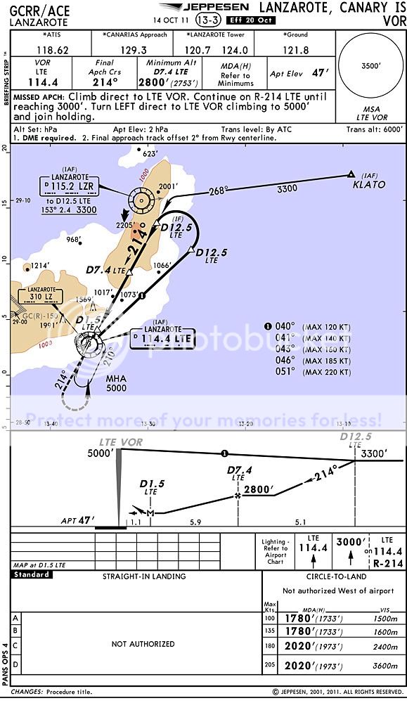
I am wondering about the VOR 21 letdown approach in ACE( lido charts). If you`re inbound LZR on the Terto 1Q arrival, which has a MEA of 5000feet and a MTCA of 3200 feet. Could you already descend to 3300 feet before LZR and start your approach from there?
I am wondering about the VOR 21 letdown approach in ACE( lido charts). If you`re inbound LZR on the Terto 1Q arrival, which has a MEA of 5000feet and a MTCA of 3200 feet. Could you already descend to 3300 feet before LZR and start your approach from there?

Joined: Aug 1998
Aviation Qualifications: ATPL
Posts: 6,623
Likes: 847
From: Ex-pat Aussie in the UK
Is Lanzarote B-RNAV airspace (has it been charted to WGS-84 standard)?
The MEA (Minimum En-route Altitude) is the lowest published altitude between radio fixes that ensures acceptable navigational signal coverage and meets obstacle clearance requirements between those fixes. If you are B-RNAV approved (and you have to be to operate in ECAC (European Civil Aviation Conference) airspace since 23rd April, 1998) then you may use your area navigation system above the terrain clearance altitude.
I would answer: Yes, depending on the status of Lanzarote.
Joined: Aug 2000
Posts: 3,648
Likes: 2
From: UK
I am wondering about the VOR 21 letdown approach in ACE( lido charts). If you`re inbound LZR on the Terto 1Q arrival, which has a MEA of 5000feet and a MTCA of 3200 feet. Could you already descend to 3300 feet before LZR and start your approach from there?
If you have been cleared direct to LZR at a lower level, then you fly direct to LZR at that level. ATC is responsible for assigning a level on a direct clearance that is terrain safe, and you can (and should) check that by comparing with MTCA or MSA.
Per Ardua ad Astraeus
Joined: Mar 2000
Posts: 18,575
Likes: 4
From: UK
It looks as if confusion again reigns at ACE with the Jepp charts. The VOR21 approach is designated 'VOR' with no runway.. The arrival terminates at the LZR at 5000' but the procedure begins at the LTE at 5000' with no arrival shown to join the dots apart from the VOR03 procedure . Like the worm says, 5000' to the LTE would be sensible/practical, but if you are cleared BRNAV to the localiser it would be either 5000', ATC clearance or 3500 within 25)
(EDIT Corrected to 3500 thanks 9.g - should have gone to Specsavers........................).
. Like the worm says, 5000' to the LTE would be sensible/practical, but if you are cleared BRNAV to the localiser it would be either 5000', ATC clearance or 3500 within 25) (EDIT Corrected to 3500 thanks 9.g - should have gone to Specsavers........................).
Last edited by BOAC; 25th October 2011 at 14:09.
Joined: Dec 2007
Posts: 559
Likes: 0
From: paradise
to answer your question in details:
1. company policy of min alt usage must be established by each operator hence you should check your manual which alt you must maintain given the choice between MEA and MTCA.
2. MSA based on LTE VOR is 3500 ft thus needless to explain that anything above is safe, within 25 NM, of course.
3. If cleared by ATC for a standard arrival a published profile must be followed which is 5000ft otherwise you commit ATC violation even though you're perfectly safe at MTCA. It's a conventional arrival based on VOR therefore MEA is applicable assuring adequate radio coverage.
I suggest next time you fly in by CAVOK just have a look around you and you'll have a pretty good picture of what you could do.
Guest
Joined: Apr 2009
Posts: 3,336
Likes: 0
From: On the Beach
BOAC:
The confusion, if such even exists, is not on the part of Jeppesen. The IAP at issue does not have straight-in minimums, thus it cannot be called the VOR RWY 21. In the U.S. and some other countries it would be called the VOR-A or VOR-B, etc, so it could be coded into RNAV databases. Because the Spanish Government (not Jeppesen) elected to simply call it "VOR" it is probably not in any RNAV database.
Following is a link to the Spanish source chart for this IAP. Please note the title:
http://www.terps.com/gcrr/source.pdf
It looks as if confusion again reigns at ACE with the Jepp charts. The VOR21 approach is designated 'VOR' with no runway.. The arrival terminates at the LZR at 5000' but the procedure begins at the LTE at 5000' with no arrival shown to join the dots apart from the VOR03 procedure. Like the worm says, 5000' to the LTE would be sensible/practical, but if you are cleared BRNAV to the localiser it would be either 5000', ATC clearance or 3500 within 25)
. Like the worm says, 5000' to the LTE would be sensible/practical, but if you are cleared BRNAV to the localiser it would be either 5000', ATC clearance or 3500 within 25)
Following is a link to the Spanish source chart for this IAP. Please note the title:
http://www.terps.com/gcrr/source.pdf
Per Ardua ad Astraeus
Joined: Mar 2000
Posts: 18,575
Likes: 4
From: UK
The Spanish chart is so much better, aterp - at least it doesn't leave you at 5000' over LZR with 2.4nm to get down to 3300at the IF. You have no min alt or hold at Klato either.
We had all that discussion about the 21 approach a while back. I wonder if the LIDO chart is better?
To go back to the OP - I would suggest using the Klato at 4000 down to 3300 would be your best option but it would have to be RNAV or ATC vectored, I guess. Then, as we know from before, you circle or declare 'visual' at 6 miles.
Joined: Jun 2001
Posts: 185
Likes: 0
From: In the State of Perpetual Confusion
Where does the chart require you to be at 5000' over LZR? The transition from LZR has a bearing of 154, distance of 2.4 and minimum altitude of 3300' (it's not well indicated but there is a transition from LZR, it's just not indicated in the profile view). With an MSA of 3500', once cleared for the approach and within 25 sm, you may descend to the MSA. At the IAF (LZR), you go to 3300'. At 12.5D, continue your descent to 2800. It's the 2800' at the FAF that leaves you high and which is probably why there are no straight-in minimums.
Now as far as an arrival dumping you over LZR at 5000', you may not make the 12.5 fix at 3300', but if you're reasonably ahead of the aircraft, you should be able to make the FAF at 2800'. It might be tight in a big aircraft in which case, I would request clearence to LTE, do the course reversal and the full teardrop procedure.
I agree with Bookworm, if on the arrival, unless specifically cleared to LZR for the approach, stay at 5000'. If you're slow and configured, 1700' in 2.4 nm is doable. I'm not sure what RNP, B-RNAV or WGS-84 has to do with the altitudes you could fly on the approach.
Joined: Aug 2000
Posts: 3,648
Likes: 2
From: UK
Where does the chart require you to be at 5000' over LZR?
With an MSA of 3500', once cleared for the approach and within 25 sm, you may descend to the MSA.
Per Ardua ad Astraeus
Joined: Mar 2000
Posts: 18,575
Likes: 4
From: UK
Originally Posted by bookworm
Why does a clearance for the approach permit you to descend to the MSA?
Joined: Jun 2001
Posts: 185
Likes: 0
From: In the State of Perpetual Confusion
Why does a clearance for the approach permit you to descend to the MSA? (i.e. what's the regulatory/ICAO reference for that?)
Now if you are cleared via the STAR, you would HAVE TO maintain the published STAR altitudes until on a published section of the approach.
