


Vor appch altitude


Fleet Manager

Joined: Apr 2001
Aviation Qualifications: ATPL
Posts: 7,448
Likes: 310
From: various places .....
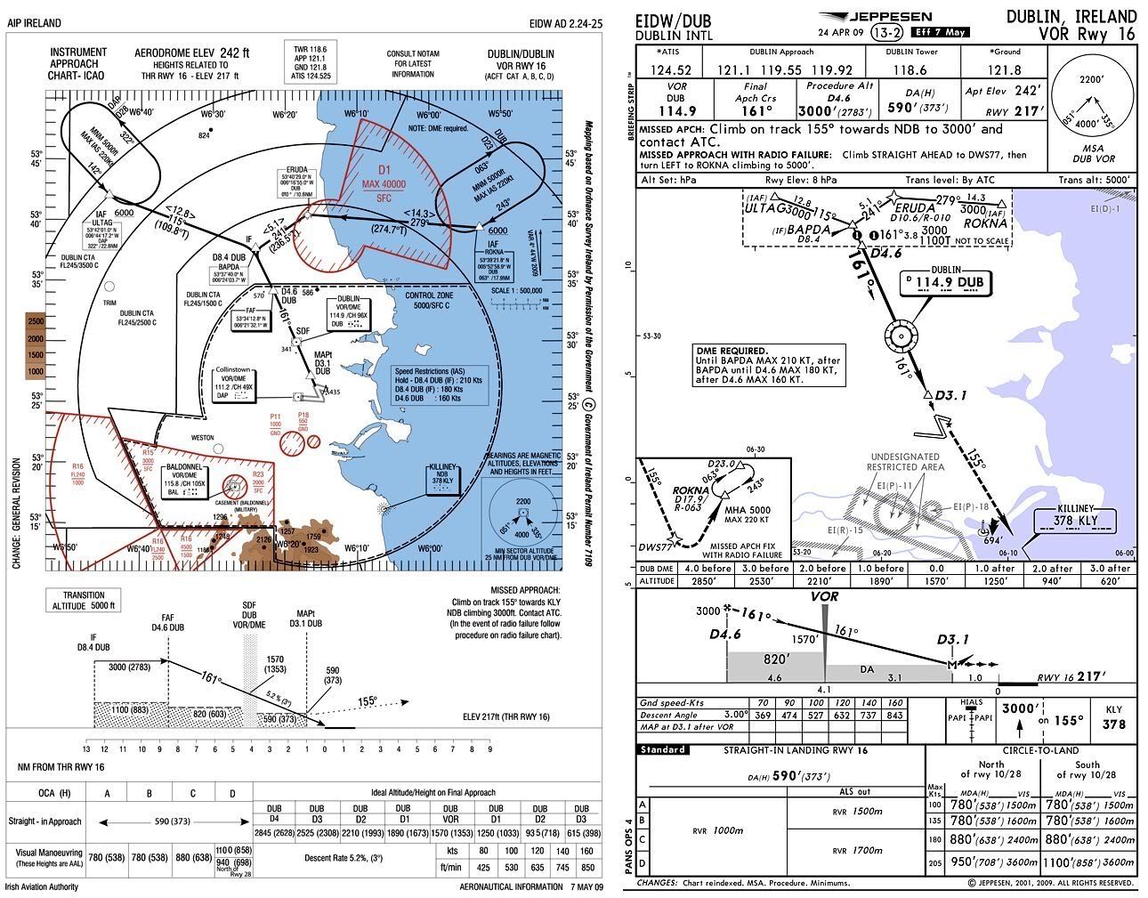
(Not sure if I'm allowed to post Jepp plate on here, so I cut it in half and drew on it)
Caveat - I have no legal competence.
However, my limited understanding on copyright is that one can copy limited exerpts from a copyright document for review, research, etc.
Until/unless one of the legal folk further up the totem pole tells me otherwise, I have no problem with a one-off post of (a) copyright document exerpt(s) for appropriate purposes in the forum.
Mind you, I thought that the smiley face was rather cute.

Joined: Apr 2008
Posts: 318
Likes: 3
From: Oz
Leebrensten,
It is the MOCA.
I've asked a Jepp rep. to explain the difference between the two altitudes. His reply was that the 3000' is where the profile/3 degree slope starts (constant angle) where as the 1100T is the lowest you can go if you choose to "dive and drive".
So the profile on the chart should show the DME/ optimum altitude from 3000'.
Clark y.
Guest
Joined: Apr 2009
Posts: 3,336
Likes: 0
From: On the Beach
John T:
It's "fair use" under US copyright law. Besides, Jeppesen just does not get excited over snippets to make a point.
However, my limited understanding on copyright is that one can copy limited exerpts from a copyright document for review, research, etc.
Joined: Feb 2000
Posts: 21
Likes: 0
From: uk
Leebrensten,
It is the MOCA.
I've asked a Jepp rep. to explain the difference between the two altitudes. His reply was that the 3000' is where the profile/3 degree slope starts (constant angle) where as the 1100T is the lowest you can go if you choose to "dive and drive".
So the profile on the chart should show the DME/ optimum altitude from 3000'.
Clark y.
It is the MOCA.
I've asked a Jepp rep. to explain the difference between the two altitudes. His reply was that the 3000' is where the profile/3 degree slope starts (constant angle) where as the 1100T is the lowest you can go if you choose to "dive and drive".
So the profile on the chart should show the DME/ optimum altitude from 3000'.
Clark y.
I think 1100 ft is also the height which is the lowest to use if your sole means of navigation is by reading road signs. It would certainly raise a few eyebrows

Joined: May 2008
Posts: 159
Likes: 9
From: Euroland
From the Jeppesen introduction section (abbreviations):
From the Jeppesen introduction section (enroute chart legend):
Nothing mentioned in the approach chart legend though.
Looking at the chart again it makes sense that you have too look for it in the enroute chart legend. It is located inside the dashed box and indicates a section of the arrival and is not part of the approach section, although the IAF is within the dashed box. Maybee I have to check the introduction section again
.
.
Edit:
Approach transition inset. Provided when route originates at an off-chart intersection designated only for approach chart use.
.
.
T - Terrain clearance altitude (MOCA)
1300T - MOCA (minimum obstruction clearance altitude)
Looking at the chart again it makes sense that you have too look for it in the enroute chart legend. It is located inside the dashed box and indicates a section of the arrival and is not part of the approach section, although the IAF is within the dashed box. Maybee I have to check the introduction section again
.
.
Edit:
Approach transition inset. Provided when route originates at an off-chart intersection designated only for approach chart use.
.
.
Last edited by bArt2; 28th August 2010 at 07:15.
Per Ardua ad Astraeus
Joined: Mar 2000
Posts: 18,575
Likes: 4
From: UK
An interesting 'approach' in view of the fear with which US pilots view MSA - it it 'safe? Is it useable OUTWITH emergencies? Is it regularly updated/surveyed? In fact is it any use at all, being below MSA?
Joined: Aug 1998
Posts: 172
Likes: 3
From my Jeppesen intro:
MINIMUM OBSTRUCTION CLEARANCE ALTITUDE (MOCA) � The lowest published altitude in effect between radio fixes on VOR airways, off airway routes, or route segments which meets obstacle clearance requirements for the entire route segment and in the USA assures acceptable navigational signal coverage only within 22 nautical miles of a VOR.
My understanding is that it does not guarantee navaid reception at that altitude.
The precise segment you refer in the VOR 16 is an approach transition (Jepp Intro Page 105 onwards) and any or all of the enroute type altitudes (e.g. in red, with a, or T afterwards) could be described due to its "enroute" nature. The approach itself only begins at the D4.6 point.
Edit for speling.
Only half a speed-brake

Joined: Apr 2003
Posts: 4,459
Likes: 136
From: Commuting not home
Here's the AIP version http://www.iaa.ie/safe_reg/iaip/Publ...W_24-25_en.pdf , the only true source to resolve anything. 1100A is the OCA for intermediate APCH segment.
Yours,
FD (the un-real)
Yours,
FD (the un-real)
 Now, what can we read next ....

Joined: May 2008
Posts: 159
Likes: 9
From: Euroland
Does the 1100T mean that after BAPDA you can descend to 1100? Is this indicated on the vertical profile?
Edit:
Well you can't see that the GS int alt is 3000 feet on the posted jepp chart snippet, but you can see it on the AIP chart posted by Flight Detent which was posted after your reply.
Joined: Jun 2009
Posts: 497
Likes: 0
From: US
http://www.iaa.ie/safe_reg/iaip/Publ...W_24-25_en.pdf
On the very bottom of this chart the 1100 ft shows up on the bottom of the vertical profile.
On the very bottom of this chart the 1100 ft shows up on the bottom of the vertical profile.
Guest
Joined: Apr 2009
Posts: 3,336
Likes: 0
From: On the Beach
p51guy:
Therein lies the problem. Jeppesen didn't comply with source as to the profile view, thus the confusing 1,100T in the out-of-scale box.
On the very bottom of this chart the 1100 ft shows up on the bottom of the vertical profile.
