


Is WAAS Accuracy Superior To ILS?

Joined: Nov 2006
Posts: 896
Likes: 2
From: SoCalif
Compare simple AM modulated LOC and GS transmitters with antennas anchored in concrete to triangulating from a bunch of tiny transmitters about 11,000 miles away.
GPS can plot your position with reference to the center of the earth, and then a model of the earth's surface tells you where you are. Did I mention software?
"Once proven, software never fails." Yeh, right. Think of the mountains of software to just show present position.
ILS is elegant and simple.
GB

Joined: May 2006
Posts: 779
Likes: 0
From: Londonish
And not centrally administered by someone in far far away who can turn it off should they so please; to me, that's far more relevant than where it was invented..
Even so, when you think about how it works, it's seriously neat technology
Even so, when you think about how it works, it's seriously neat technology
Guest
Posts: n/a
Pity the Europeans.
They appear to be so far behind with the acceptance of GPS, it is a real shame.
One wonders just when they will get their own system up and running.
Don't hold your breath.
They appear to be so far behind with the acceptance of GPS, it is a real shame.
One wonders just when they will get their own system up and running.
Don't hold your breath.
The problem is GPS/Navstar is controled by USAF/DoD... and OK lets say the Europeans are for pity... Are the North Koreans also for pity? China? Russia? Have you heard about selective availability (SA)?
Galileo will be civil controled, and China has part of the cost (some 100s M$), at the same time they have a local system on their own.
Can you imagine using GPS around the world for CAT-X landings and DoD shutting it down (SA) for parts of the world cuase DoD doesn't like the foreign policy there?
Sometimes its about independence my friend and not money.
It's like energy... what's wrong with arab's oil and you are shifting to biofuels in the states? Is it only cost/carbon emissions? or energy independence from unstable partners??... (and votes from farmes becoming oil-producers
 )
)
Aviator
Joined: May 2001
Posts: 483
Likes: 0
From: Norveg
Europeans lagging?
I do remember something about Norway (that's in Europe, in case any Yankees are reading this ) being the first ever to implement ground based DGPS for Wider�e's SCAT-1 operations into Norwegian STOL-ports. The Norwegian CAA took over the testing and certification from FAA. 
The ground stations are developed by Northrop Grumman
) being the first ever to implement ground based DGPS for Wider�e's SCAT-1 operations into Norwegian STOL-ports. The Norwegian CAA took over the testing and certification from FAA. The ground stations are developed by Northrop Grumman
Joined: Jun 2010
Posts: 4
Likes: 0
From: brazil
WAAS is more accurate than ILS at the outter marker
WAAS is easily more accurate than ILS at the outter marker.
Even at CAT I DH its still more accurate than ILS.
However after the DH, ILS becomes more accurate than WAAS.
But that's concerning today's single frequency WAAS receivers.
With dual frequency, triple constellation SBAS that should be ready to go by 2025, SBAS accuracy should be better than 2 meters in its whole core coverage area, not only in the final approach course !
2 meters accuracy will be enough for CAT II and CAT IIIa.
And for more efficient enroute / approach spacing, such ultra high accuracy positioning added to ADS-B should allow for 500ft vertical spacing at any flight level, since SBAS altitude actually gets more accurate at higher altitudes (more satellites in view), at FL 300, 30-45 satellites would be in view from a combined GPS+Galileo+GLONASS+SBAS GEO network.
WAAS makes is soo much easier to precisely and quickly join a virtual localizer and glideslope at any distance from the runway, as the SBAS receiver can tell exactly how far you are from the extended centerline, glidepath, and your PRECISE groundtrack course, no need to feel the wind. Something like 0.29nm left, 93ft low, 2.3 degrees intercept course (updated at least twice every second). Even with regular GPS, all that information is available, its just not as trustworthy as with SBAS.
The main issue is the politics behind SBAS / GBAS discourages enhancements to SBAS that make it better than GBAS ! Since billions of dollars have been invested in GBAS, there's a large vested interest in GBAS, also, SBAS is only viable if deployed on at least a continental basis, national barriers conspire against SBAS worldwide adoption. Finally the big plane / small plane separation mentality also discourages development of single/complete solutions that can be used on any size aircraft. The next generation of navigation gear should unify equipment design, so that a single, low cost solution can be used for any size aircraft, merging the SBAS sensor with the FMS, allowing for economies of scale to bring most FMS features into all IFR aircraft.
SBAS was designed to work with just 5 GPS satellites in view, while with todays full GPS constellation, 8-12 satellites is common, add just a full Galileo constellation, and 16 satellites minimum will be the norm. That's akin to a 500% safety margin improvement.
At the same time all SBAS limits are based on theorethical worst case mathematical calculations instead of real world results about 4x better ! If the FAA were to use just worst case real world results, CAT II would be available today with current SBAS (even on a little spam cam). But they have no incentive to make that happen. Too many economical interests would be hurt if that were to become reality.
Joined: Mar 2011
Posts: 1,407
Likes: 0
From: engineer at large
The direction is simple, there will be WAAS and GBAS in the future.
WAAS is sat based, hence the SBAS designation. The WAAS signal contains 2 parts, the sat correction factor, and a local ionospheric delay correction factor. The LPV-200 has very specific requirements, and unless there is a ground station at the airport location, you wont likely get a good enough correction factor for the 200' minima.
The WAAS will replace CAT I ILS, and will be the vertical guidance for smaller airports where GBAS infrastructure doesnt make sense. WAAS is a little more complicated, (and expensive) than people believe. Ground stations feed master stations, and master stations feed sats, which the ac receives, and must have a WAAS MMR. (2 systems, just like GPS are required)
Since WAAS is also based on GPS, all of the same issues with RAIM, prediction, outages, etc still have to be accounted for.
The GBAS will be the approach guidance for commercial aircraft, down to CAT III autoland, for all the major airports. All new Boeing and Airbus aircraft, as well as the 787 are GBAS equipped.
Last edited by FlightPathOBN; 17th June 2012 at 18:26.
Joined: Mar 2001
Posts: 4,563
Likes: 35
From: I wouldn't know.
All our boeings delivered since 2006 are equipped with a GLS (or GBAS) capable MMR, so that nearly our complete boeing fleet is GLS capable. Boeing offered that as standard equipment at no additional cost. Sadly the same isn't true for the airbus fleet as airbus doesn't offer GLS as a user option on the small bus (yet).
Neither the airbus nor the boeing fleets are SBAS capable so far, however RNP-AR allows for a 250ft minimum which is close enough to a normal ILS CAT I approach where needed. So GLS is a reality for the last few years, SBAS isn't. Of course europe is as always somewhat behind, EGNOS is now certified and the first approaches with it will be designed and published, but currently it doesn't play any commercial role.
Neither the airbus nor the boeing fleets are SBAS capable so far, however RNP-AR allows for a 250ft minimum which is close enough to a normal ILS CAT I approach where needed. So GLS is a reality for the last few years, SBAS isn't. Of course europe is as always somewhat behind, EGNOS is now certified and the first approaches with it will be designed and published, but currently it doesn't play any commercial role.

Joined: Mar 2011
Posts: 1,407
Likes: 0
From: engineer at large
Concur with Denti.
For a commercial ac to fly SBAS, it must have the dual system, follow the same RAIM issue and obstacles. There is little desire to either add this to the ac, or get the ac certified, considering the limited value compared to GPS (RNP) or GBAS.
For a commercial ac to fly SBAS, it must have the dual system, follow the same RAIM issue and obstacles. There is little desire to either add this to the ac, or get the ac certified, considering the limited value compared to GPS (RNP) or GBAS.

Joined: May 2012
Posts: 88
Likes: 0
From: Earth
..sunspots, military degredation of GPS accuracy, RAIM issues...
Most GPS approaches are overlays, so it's nice to put the VOR. NDB, ILS into the back ground as a back up..
Do a few stand alone GPS approaches where you don't even have cross radials to double check where you are on the approach, then we can talk about WAAS accuracy.
That said, few pilots are willing, or able, to take the planes down to 100 feet in the soup....so it's accurate 'enough'.
Joined: Mar 2011
Posts: 1,407
Likes: 0
From: engineer at large
250ft minimum which is close enough to a normal ILS CAT I approach where needed.
To use LPV200, the requirements are a bit formidible...
Last edited by FlightPathOBN; 17th June 2012 at 23:31.
Joined: Sep 1998
Posts: 1,615
Likes: 1
From: wherever
EGNOS has been offering SoL service capability since March last year. The service is dependant on meeting strict minimum service performance characteristics based on the familiar accuracy,integrity,availability and continuity principle of GNSS. The service is capable of NPA and APV-I standards and all you need is certified kit and ops spec.
We are a decade behind the rest of the world here in Europe and it's mostly for reasons of ignorance and arrogance.
Anyone trotting out the selective availability argument needs to read US gov policy on GPS from 2000 and 2004 to see why EGNOS can offer SoL services.
We are a decade behind the rest of the world here in Europe and it's mostly for reasons of ignorance and arrogance.
Anyone trotting out the selective availability argument needs to read US gov policy on GPS from 2000 and 2004 to see why EGNOS can offer SoL services.
Joined: May 2012
Posts: 88
Likes: 0
From: Earth
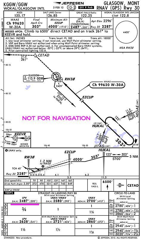
Actually no. Notice that round thing in the middle of the airport? It's called a VOR. Probably an overlay approach.. GPS goes down, you have ground base navs as back up. Honestly that's about as good as it gets. You loose your GPS, you follow the 303 inbound for straight in or cirlce (2780) use DME to catch the 1.2 for the VDP, miss at the VOR.
Check out Hollister, CA. You have nothing but the GPS to rely on.
Check out Hollister, CA. You have nothing but the GPS to rely on.
Joined: Mar 2011
Posts: 1,407
Likes: 0
From: engineer at large
Actually, that is not correct. Two straight ins do not make an overlay.
The approach surfaces, obstacle surfaces, splays, etc, and about everything else is different.
Now if you say the WAAS is an ILS overlay, then that has some commonality.
The approach surfaces, obstacle surfaces, splays, etc, and about everything else is different.
Now if you say the WAAS is an ILS overlay, then that has some commonality.
Joined: Mar 2002
Aviation Qualifications: ATPL
Posts: 9,222
Likes: 987
From: Seat 1A
Actually no. Notice that round thing in the middle of the airport? It's called a VOR. Probably an overlay approach..
Airport & FBO Info for KGGW WOKAL FIELD/GLASGOW INTL GLASGOW MT
Last edited by Capn Bloggs; 22nd June 2012 at 23:41. Reason: Couldn't subract 293 from 303! Tks OK465
Guest
Joined: Apr 2009
Posts: 3,336
Likes: 0
From: On the Beach
Both VOR approaches at GGW are what TERPs calls "On Airport, No FAF" VOR IAPs. In such a case the VOR station must be the MAP.
Also, the runway alignment requirements for straight-in VOR approaches are quite different from RNAV IAPs.
Also, the runway alignment requirements for straight-in VOR approaches are quite different from RNAV IAPs.