


Route to Singapore

Thread Starter
Joined: Jan 2008
Posts: 11
Likes: 0
From: EXETER
Route to Singapore
Hi
In October i am flying on SQ319 Heathrow to Singapore and then on to Lombok on SQ5220.As its my first long haul flight i would be interested in what route we will be taking.
MTIA
MELVYN
In October i am flying on SQ319 Heathrow to Singapore and then on to Lombok on SQ5220.As its my first long haul flight i would be interested in what route we will be taking.
MTIA
MELVYN

Warning Toxic!
Disgusted of Tunbridge
Disgusted of Tunbridge
Joined: Jan 2005
Posts: 4,011
Likes: 1
From: Hampshire, UK
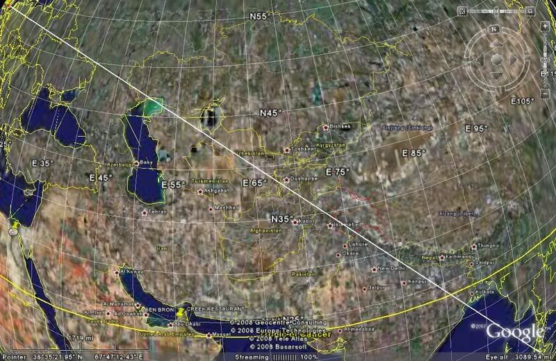
Probably SE across Europe to Black Sea passing just south of Crimea peninsula, overhead Baku on Caspian, across Iran, Pakistan, overhead Delhi, Calcutta, or over Vishakapatnam on the east coast of Indiasome and Phuket and down Malay peninsula. The Kyrgistan mountains and Himalayas are major obstacles- flying over them is not possible because of pressurisation considerations.
Plane will have live route maps on the video screen. Be ready for 8 hour time change and feeling far more tired than you anticipate!
Plane will have live route maps on the video screen. Be ready for 8 hour time change and feeling far more tired than you anticipate!
Joined: May 2008
Posts: 429
Likes: 0
From: UK
You might be interested in this - it's a Great Circle mapper using NASA's Blue Marble images. Long haul flights tend to follow the Great Circle, and using this you can get a rough idea of the path your flight may take.
Great Circle Mapper using the NASA Blue Marble Images : V-Flyer: The Virgin Atlantic Flyer Resource
Great Circle Mapper using the NASA Blue Marble Images : V-Flyer: The Virgin Atlantic Flyer Resource


 [/IMG]
Joined: Mar 2008
Posts: 198
Likes: 0
From: cloud 9
Usually as RAINBOE has listed except Baku to Ashgabat then over Afghanistan to near Multan (Pakistan) then Delhi, Calcutta, Phuket, Kuala Lumpur to Singapore. It's a more Westerly track than the Great Circle suggests (oxygen considerations over the Hindu Kush and western Himalayas). If you can get a window seat, the left side will give you a good view of the Himalayas ( Mount Everest will be just visible in the far distance, cloud permitting,as you approach Calcutta). Flight time will be approx. 12 hours and brace yourself for the humidity in SIN, if you are spending any time there!
Warning Toxic!
Disgusted of Tunbridge
Disgusted of Tunbridge
Joined: Jan 2005
Posts: 4,011
Likes: 1
From: Hampshire, UK
Yes- probably a more common route than I gave as far as Delhi is across southern Denmark to southern Baltic states, pass just south of Moscow, then southeast across Khazakhstan over Kabul, across Pakistan by Lahore and then Delhi. It gets dark early and light again unnaturally early. You usually spend a short day flying across Asia and get to SIN in the dark. You will find it far more tiring than you anticipate!
Joined: Oct 2006
Posts: 233
Likes: 0
From: Manchester, UK
Why isit you car'nt fly over the Himalayas.What would happenp
Therefore if anything like that happens, you're not going to be able to descend to the altitude you need to be at - If you tried you'd crash into the Himalayas.
Warning Toxic!
Disgusted of Tunbridge
Disgusted of Tunbridge
Joined: Jan 2005
Posts: 4,011
Likes: 1
From: Hampshire, UK
You can fly over any mountains, you don't have to immediately descend- that's what O2 masks are for. Pilots will be aware of that leg's 'safety altitude which will be an altitude to pass over any peak in that corridor, and that will be the lowest you can descend. But you have to descend further before the O2 runs out. When you pass over the northern edge of the Himalayas/Western China mountains, you fly as near direct as you can bearing in mind 'escape routes' where if you lose an engine or have a depressurisation, you can get out of trouble and clear of the mountains. Near Urumchi in western China is like this. It means you cannot pass over large mountain ranges, but ranges like the Alps or Pyrenees are no problem.

FX Guru
Joined: Feb 2001
Posts: 901
Likes: 0
From: Greenwich
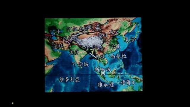
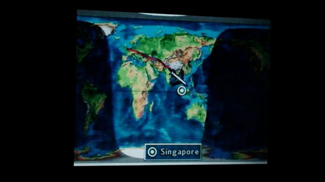
Wub - Thanks for posting the pix, they bring back great memories!
OP - I did the Singapore run quite a few times in the 90s, I used to live in Singers. I always remember the route as effectively being a 45 degree line on the flight map -- as Wub's pictures show.
There were are often variations though. I once remember (flying to London), routing over Iran, flying down the Med and then up from Italy where I got great view of Mount Vesuvius. I presume the jetstream was playing tricks that day. We arrived on time though.
On the way out you may get to experience some tasty CAT over the Bay of Bengal/Andamans, it can be fun!!

Joined: Aug 2007
Posts: 93
Likes: 13
From: Ireland
Do some aircraft have extra Oxygen supplies to enable them to operate over areas such as the Himalayas? In some of the discussion of the Qantas 747 decompression due to exploding O2 tanks reference was made to extra tanks being fitted to some 747s for operations over or close to the Himalyas or the Tibetan plateau.

