


smoke over New York


Moderator
The smoke can certainly make VFR flying a problem! I flew the DHC Beaver from British Columbia to Ontario three weeks ago in the worst of the smoke in Alberta and Saskatchewan. Though it was technically VMC the whole route (no clouds at all through Alberta and Saskatchewan), 4000 feet above the ground, I could see the ground, but not more than a couple of miles along the ground down sun, and zero along the ground into the sun. Doable VFR, and legal, but not much fun. It cleared up again through Manitoba, with unlimited visibility, but then I hit a wall of the concentrated smoke in northern Ontario, which was impassible. I had to divert and land, and wait for its movement with the passage of the associated front. It was much more dense than I had encountered in Alberta, and it was Alberta smoke (according to the weather office) not from within Ontario!
Two weeks later (last week) in Ontario, we had Quebec smoke, which again took us to the limit of VMC, and smelled unpleasant.
It's an annoyance, but nothing to complain about in the context of hundreds of families whose homes were burned with no opportunity for them to remove their valued possessions - so, I'm not complaining about some smoke.
Hi, I am from Europe, and wonder what effect the smoke from Canada has on flying ??
Dangerous ??
Dangerous ??
Thread Starter
Join Date: Nov 2003
Location: Germany
Posts: 137
Likes: 0
Received 0 Likes
on
0 Posts
Sounds serious, very. Any warnings, like are there charts out that show where the smoke will be thickes or so ? I mean charts for flying, aviation, not the general public ?
Moderator
When I flew through it a few weeks ago, it was presented in the forecasts, but there was less real time information other than METARs for each airport along the way. In the case of my trip, there were hundreds of miles between reporting airports, so it was a guessing game in between the airports.The weather people knew the smoke was there, but intensities in specific areas (other than reporting airports) was a bit more of a mystery.
Moderator
In certain areas of Canada, the weather observation locations are too far apart, so weather information is more "area" presented, based upon predicted weather patterns and area forecasts. Smoke does not always follow the flow and patterns which typical weather does - which I observed first hand. I found a concentrated "front" of smoke ahead of a known weather front. I could see by radar that the weather front had rain, and was not forecast to be less than VMC, but I was stopped by IMC smoke before I reached the rain. The front had somehow concentrated the smoke along the weather front. I diverted, and reported this to the weather office. But, with a hundred or so miles between weather observation points, they had no way of knowing that phenomenon was happening there.
Thread Starter
Join Date: Nov 2003
Location: Germany
Posts: 137
Likes: 0
Received 0 Likes
on
0 Posts
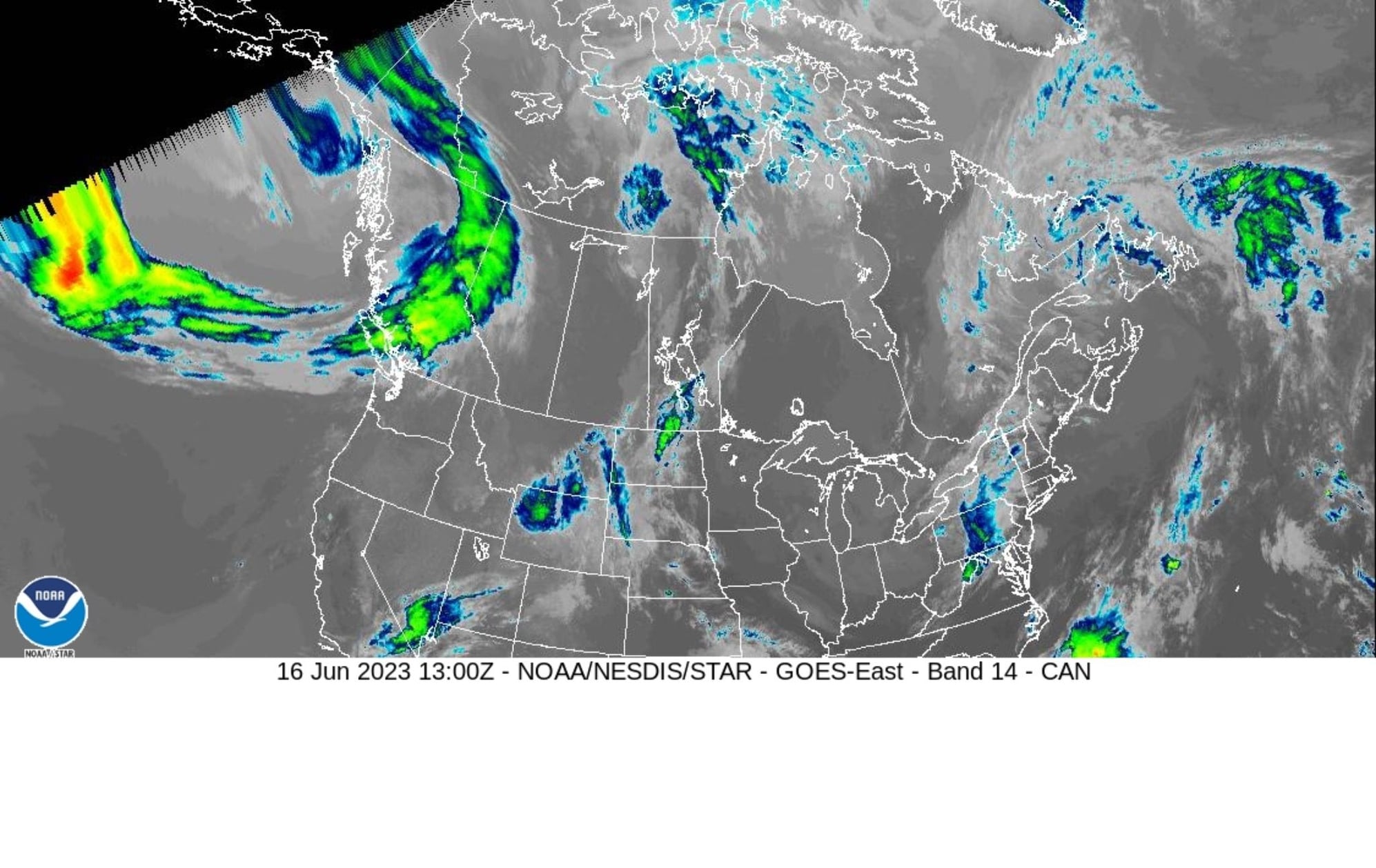
Thank you DAR for the info. Looks reasonable: reporting points far apart = not much in he way of smoke reporting. Satellite pictures, maybe ? Just a thought.
A sat photo. Notice the smoke plumes along the Quebec Ontario border heading south. Sorry I could only save a snapshot. Also the GAF may be of help. FYI in Canada FU is the abbreviation for Smoke and BR is fog FSTFR is forest fire. https://flightplanning.navcanada.ca/...nnu&Mode=graph
Last edited by albatross; 16th Jun 2023 at 17:29.

Join Date: Nov 2000
Location: Canada
Posts: 603
Likes: 0
Received 0 Likes
on
0 Posts
An Indonesian Airbus A-300 that left Jakarta carrying 234 people crashed as it approached an airport on the neighboring island of Sumatra, part of a vast region where thick smoke from forest fires has cut visibility.
Story Link:
https://www.nytimes.com/1997/09/27/w...oke%20or%20not.
Story Link:
https://www.nytimes.com/1997/09/27/w...oke%20or%20not.
Thread Starter
Join Date: Nov 2003
Location: Germany
Posts: 137
Likes: 0
Received 0 Likes
on
0 Posts
@ Albatros: thank you for the picture. Not quite clear what�s smoke and what�s another cloud, but yes, if you know where to look, you can see a bit.
@Longtimer : thank you for the NY times article. That made me look for the accident report.
Found it herre: http://knkt.dephub.go.id/knkt/ntsc_a...l%20Report.pdf
Visibility 300 - 400 m due to SMOKE !!
Of course, the ��cause�� identified was not ��smoke��, but something else. Quote is below.
Thanks for the hint !
Klauss
Quiote from the accident report
Synopsis On 26 September 1997, the Garuda Flight GA 152 departed from Soekarno-Hatta International Airport, Jakarta at 04:41 UTC with an estimated time of arrival at 06:41 UTC. The weather en-route was reported clear with scattered clouds. The visibility at Medan Polonia International Airport was less than 500 meters due to the smoke of forest fires in Riau, South Sumatera and Kalimantan. Approaching Polonia International Airport, Medan, the aircraft followed the instructions of Medan Approach, based on local radar vectoring guidance. Just seconds before impact the flight crew became aware that they were below the assigned altitude of 2000 ft. In spite of the immediate corrective action taken by the crew, the aircraft struck a treetop on a ridge at about 1550 ft above sea level, separating about nine feet of the right-hand wing tip. It rendered the aircraft uncontrollable, spilling fuel along its final track until it hit the ground in an abandoned rice field at the bottom of a ravine approximately 600 meters from the first tree impact. The crash location was at Latitude N 03�20�28.2�, Longitude E 98�34�26.6�, approximately 14.6 NM south west (205 degrees magnetic) of Polonia Airport. The aircraft was totally destroyed and the accident was non-survivable and all persons on board perished, including 222 passengers and 12 crewmembers. The flight data and cockpit voice recorders indicated that the aircraft was in controlled flight until it struck trees at the top of a ridge. Consequently, this accident may be categorized as a Controlled Flight Into Terrain (CFIT). CFIT accident is characterized by a loss of three-dimensional spatial awareness. It was found that a number of factors contributed to the flight crew�s loss of spatial awareness, vertical as well as horizontal.
Unqoute
