


Malaysian Airlines MH370 contact lost

Vin Rouge
You may be correct, but a couple of thousand posts ago, so very knowledgeable posters were very sure the area was watched 24/7, especially watching for flashes (missiles), etc., etc.
There have been no other sea, ground, or air witnesses to any type of explosion or fireball.
There have been no other sea, ground, or air witnesses to any type of explosion or fireball.

Join Date: May 2013
Location: UK
Age: 56
Posts: 85
Likes: 0
Received 0 Likes
on
0 Posts
IF you had excellent radar coverage, or satellite images of a neighbours territory, but didn't want to reveal that, maybe using a shaman to reveal the location of the wreckage would be one way of doing it.
Join Date: Aug 2009
Location: Germany
Age: 67
Posts: 1,777
Likes: 0
Received 0 Likes
on
0 Posts
Hi,
This is normal
The zone near the last know position was the first zone investigated but with no good search devices ..
Two years later they find it because the US investigation company used good devices ....
It is also worth remembering that it took 22 months to locate AF447 on the ocean floor, despite the location being very close to its last known position.
The zone near the last know position was the first zone investigated but with no good search devices ..
Two years later they find it because the US investigation company used good devices ....
Join Date: Nov 2013
Location: California
Posts: 154
Likes: 0
Received 0 Likes
on
0 Posts
It's time to summarize again.
* All transponders were lost or shut down in the middle of Gulf of Thailand, at N6.92 E103.58, at 1:20 local time.
* No debris related to the plane were found anywhere near the spot.
* Shortly thereafter (~1:45), multiple witnesses saw a large plane flying at low altitude above Kota Bharu, 90 NM southwest of last known location.
* Shortly after that (~2:15), Malaysian air force reports tracking an unidentified radar target at FL295 in Malacca Strait off the coast of Phuket, 320 NM west-northwest of last known location.
* We know about a report by a Kiwi rig worker who saw a burning plane. He is unsure about the range, but his observation puts the plane roughly at N8.3 E107.5, or 250 NM east-northeast of last known location.
* Chinese satellites picked up large floating objects at N6.7 E105.63, or 120 NM east-southeast of last known location.
Join Date: Jun 2009
Location: California
Age: 54
Posts: 203
Likes: 0
Received 0 Likes
on
0 Posts
Eye witness on rig
Having read the Mike McKay eye witness email it appears to fit with the scant info we know. He would not at the time be able to see the a/c (night) or have known its flight path. Seeing a cruise altitude flame trail would I think be possible given dark, clear skies and if he had his night vision.
A 10-15 second time frame makes it sound like a single catastrophic failure took the a/c down which would agree with the total lack of comms. This is probably the best (only?) available evidence so hopefully they will trawl/sonar the reported area.
Given that his identity has been released it is unlikely to be a hoax.
Join Date: Jul 2013
Location: Las Vegas NV.
Age: 63
Posts: 165
Likes: 0
Received 0 Likes
on
0 Posts
I hope the latest news leads to finding the aircraft. Honestly, as scattered as the search has been so far, they are about as likely to find Amelia Earhart as the 777. 

Join Date: Jul 2007
Location: Germany
Posts: 1
Likes: 0
Received 0 Likes
on
0 Posts
if i were a betting man, the chinese naval exercise around taiwan may have already picked up a pinger from the fdr. as alluded to, it looks as if the chinese know where it is, as the organisation they used to release the sat pics is probably state run.
matter of time before they find the wreckage.
matter of time before they find the wreckage.
Join Date: Nov 2013
Location: California
Posts: 154
Likes: 0
Received 0 Likes
on
0 Posts
With the SAT images posted on the always well informed avherald, China shows both its irritation and supremacy, albeit with respectable restraint. Under the guise of the Chinese science services, some low res pictures are shown for where exactly to look. No doubt our friends already know beyond doubt that this is where things ended up, because they surely have high res pics from other native sources than the science ones..... Good show ! It would make sense, after total comms/energy failure from FL 35 to end up gliding some 120 nm towards the right turn planned for 045 that had just been commenced from 025....
Originally Posted by hamster3null
It's time to summarize again
* All transponders were lost or shut down in the middle of Gulf of Thailand, at N6.92 E103.58, at 1:20 local time.
* No debris related to the plane were found anywhere near the spot.
* Shortly thereafter (~1:45), multiple witnesses saw a large plane flying at low altitude above Kota Bharu, 90 NM southwest of last known location.
* Shortly after that (~2:15), Malaysian air force reports tracking an unidentified radar target at FL295 in Malacca Strait off the coast of Phuket, 320 NM west-northwest of last known location.
* We know about a report by a Kiwi rig worker who saw a burning plane. He is unsure about the range, but his observation puts the plane roughly at N8.3 E107.5, or 250 NM east-northeast of last known location.
* Chinese satellites picked up large floating objects at N6.7 E105.63, or 120 NM east-southeast of last known location.
3 is hearsay, based on unverified news reports which have been neither confirmed nor denied by any competent authority
4 was hinted, confirmed, denied and admitted in this order. Make of it what you like.
5 was pretty convincingly discredited by a number of posts on this forum
6 seems to be from a credible source, let's see...
So far aside 6, not much new if compared to my summary in post 997 (http://www.pprune.org/rumours-news/5...ml#post8362282) on page 50.
(Original post quoted in full in case server mis-behaves again)
Along the same lines, an exceptionally good summary of what we know so far from the Straits Times: http://www.straitstimes.com/the-big-story/missing-mas-plane/story/possible-sighting-mh370-north-west-penang-mystery-and-confusion (They even explain the difference between primary and secondary radar, something 99% of the word press failed to comprehend. Only in Singapore...)
Last edited by andrasz; 12th Mar 2014 at 21:32.
It has puzzled me throughout his thread that there has been little focus on the Vietnam aspect. After all it now seems likely that it is Vietnam who lost contact not Malaysia since the last words from the plane were to acknowledge a 'contact Vietnam on xxx.yyy.After that its goodnight as far as The Malay or Singapore area controller is concerned isn't it? So now we have an ATCO in Vietnam no doubt with a flight strip or electronic equivalent telling him MH370 is going to check in any moment.-Trouble is , it doesn't ,so what does he do-since an Atco needs decent English as well as an ability to work with complex equipment he is probably a young and keen and therefore alert guy since that's probably a good job in 'nam. He waits and waits and then starts calling MH370 gets no reply and then contacts the handing over party to say-where is MH370 . and given Vietnams status and history he probably has a Mil controller to hand who he can talk to in order to see if he can spot MH370 on his Mil kit. How long does all this take because it seems to me it could easily take 15-20 mins which is about 150 miles further down whatever track MH370 was headed and if the comms went before the plane headed downwards for whatever reason the real search area is pretty huge. And as has been suggested if the Chinese military have good satellite imagery coverage of the area they are not going to immediately blurt out 'guess what we have just seen' are they.
In addition some posters way back suggested that the engine parameter monitoring by RR was not continuous in terms of reporting but only when thrust levels change. If the 'transponder off-dive to 500' asl people are to be believed surely the engine thrust has to be substantially reduced (this triggering another set of engine data) to avoid the plane just wildly over speeding by diving with cruise thrust settings. What link is used to send the engine data to RR
In addition some posters way back suggested that the engine parameter monitoring by RR was not continuous in terms of reporting but only when thrust levels change. If the 'transponder off-dive to 500' asl people are to be believed surely the engine thrust has to be substantially reduced (this triggering another set of engine data) to avoid the plane just wildly over speeding by diving with cruise thrust settings. What link is used to send the engine data to RR
Join Date: Jul 2004
Location: Found in Toronto
Posts: 615
Likes: 0
Received 0 Likes
on
0 Posts
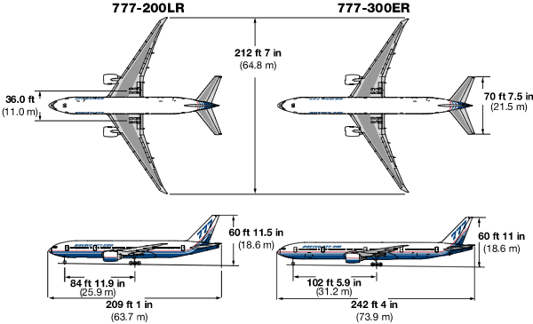
The largest piece spotted by the Chinese satellite is 79 feet by 72 feet.
My first instinct is that it seems too large to be from a 777. Especially since it is floating on the surface.
My first instinct is that it seems too large to be from a 777. Especially since it is floating on the surface.
Join Date: Jun 2008
Location: Ventura, California
Age: 65
Posts: 262
Likes: 0
Received 0 Likes
on
0 Posts
Geostationary
geostationary is pointless for a recon sat (unless its a weather bird) as you can only take a picture of a limited area. so unless you want to look at a particular area constantly for a long time, most of the sorts,of assets that would be useful would be non geostationary.
We use that location because there is only ocean south of Vandenberg for 1000's of miles, so if the booster fails, their is a low probability of damage to anything on the surface.
We also send up a lot of highly classified birds out of Cape Kennedy, Florida. There are 2 reasons to use Kennedy. First, you've got about 1000mph of speed because of the earth's rotation, and that saves a lot of fuel. The other reason is that it's the most efficient base we have from which to launch satellites into geostationary orbit. Geostationary orbits have to be about 25,000 miles above the planet, far higher than the polar orbit birds launched out of Vandenberg.
Geostationary does not mean it cannot be moved and parked over a specific area. It can, depending on what you want to look at. But it does have to be near the equator. South or north of the equator the angle of view becomes more oblique, and the light passes though more atmosphere, causing increasing scintillation and a corresponding degradation of the image.
Last edited by thcrozier; 12th Mar 2014 at 21:43.
Join Date: May 2008
Location: Cork
Age: 45
Posts: 38
Likes: 0
Received 0 Likes
on
0 Posts
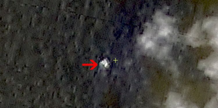
Tail, one wing and then everything else? As was said it would be surprising if the fuselage would still float.
The 2nd picture does look like a fuselage with wings or a tail section if you take away the cloud in the middle.
The 2nd picture does look like a fuselage with wings or a tail section if you take away the cloud in the middle.