


new Garmin helo products

Thread Starter
Join Date: Mar 2008
Location: Homer, Alaska
Posts: 177
Likes: 0
Received 0 Likes
on
0 Posts
new Garmin helo products
Garmin Helicopters
Garmin's New Products Target Copter Cockpits
Garmin's New Products Target Copter Cockpits
Garmin G500H
According to the FAA, the three main areas of risk in helicopter operations are: inadvertent flight into IMC, night operations, and controlled flight into terrain. Garmin has addressed all three with two new products, announced this morning, for the rotorcraft market; the Garmin Helicopter Terrain Awareness Warning System (HTAWS), designed for GNS 430W and 530W navigators; and the G500H, designed for the VFR Part 27 helicopter market. HTAWS, with forward looking terrain avoidance (FLTA) is expected be available in the second quarter of this year on new GNS 430W/530W units as a $9,995 option, and also as a field retrofit upgrade for existing units. The G500H is derived from the G600 and G500 fixed-wing products, but adds optional helicopter-specific features, including: synthetic vision technology (HSVT) for an "out-the-window" view; helicopter-specific databases with more than 7,000 heliports and close to 30,000 additional low-altitude obstacles; and inputs to display images from forward looking infrared (flir) cameras or other video sources. Garmin expects the G500H system to be available at an introductory price of $24,995 (HSVT is a $7,995 option) when STCs for Bell Models 206 and 407 are expected in the second quarter of this year. The G500H will be on display at Garmin's booth during next week's Heli-Expo show in Houston, Feb. 21-23. The G500H system includes two 10-inch-by-6.7-inch screens � a primary flight display (PFD) and a multifunction display (MFD). The system comes in two versions, with the primary flight display mounted either on the left or right of the cockpit. XM WX Satellite Weather from Garmin's GDL 69 receiver can also be displayed on the MFD, as can traffic information from Garmin's GTS 800, GTS 820 and GTS 850 products. For more information on both products, go to garmin.com/helicopters.
According to the FAA, the three main areas of risk in helicopter operations are: inadvertent flight into IMC, night operations, and controlled flight into terrain. Garmin has addressed all three with two new products, announced this morning, for the rotorcraft market; the Garmin Helicopter Terrain Awareness Warning System (HTAWS), designed for GNS 430W and 530W navigators; and the G500H, designed for the VFR Part 27 helicopter market. HTAWS, with forward looking terrain avoidance (FLTA) is expected be available in the second quarter of this year on new GNS 430W/530W units as a $9,995 option, and also as a field retrofit upgrade for existing units. The G500H is derived from the G600 and G500 fixed-wing products, but adds optional helicopter-specific features, including: synthetic vision technology (HSVT) for an "out-the-window" view; helicopter-specific databases with more than 7,000 heliports and close to 30,000 additional low-altitude obstacles; and inputs to display images from forward looking infrared (flir) cameras or other video sources. Garmin expects the G500H system to be available at an introductory price of $24,995 (HSVT is a $7,995 option) when STCs for Bell Models 206 and 407 are expected in the second quarter of this year. The G500H will be on display at Garmin's booth during next week's Heli-Expo show in Houston, Feb. 21-23. The G500H system includes two 10-inch-by-6.7-inch screens � a primary flight display (PFD) and a multifunction display (MFD). The system comes in two versions, with the primary flight display mounted either on the left or right of the cockpit. XM WX Satellite Weather from Garmin's GDL 69 receiver can also be displayed on the MFD, as can traffic information from Garmin's GTS 800, GTS 820 and GTS 850 products. For more information on both products, go to garmin.com/helicopters.
Last edited by Senior Pilot; 18th Feb 2010 at 22:57. Reason: Change link to Garmin


Join Date: Nov 2008
Location: UK
Posts: 91
Likes: 0
Received 0 Likes
on
0 Posts
My 420 Garmin already has a warning where the screen shows terrain in yellow if I descend below a preset agl (unless landing on a route).
Because it's yellow, it's incredibly obvious. I set it at a height where, if I've got that low due to weather, the decision is then made to make a precautionary landing.
There are many features on the existing database, but I guess this has far more.
Seems a lot of additional cost bearing in mind the rather clunky look of the 420 screens these days vs the competition.
Lafite
Thread Starter
Join Date: Mar 2008
Location: Homer, Alaska
Posts: 177
Likes: 0
Received 0 Likes
on
0 Posts
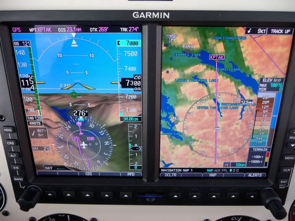
The beauty of this isn't terrain on the 400/500W series, but the low cost (relative term) EFIS Garmin is introducing that is helicopter specific. We fly the G600 in a float plane and the displays and synthetic vision are a big help in areas of terrain. Here is a photo from this past summer showing the displays and synthetic vision.
The Sagem integrates engine displays, where the Garmin relies on the factory engine gauges. The Garmin is a fraction of the cost of Sagem or Chelton, and to my eyes, has much, much better displays.
Not sure where you fly, and land whenever you enter yellow on the 430/530 terrain page. Most flights, we disable the terrain alerts on the 430/530 as we generally don't get high enough to get out of the yellow/red area.
PS: At the web link I posted above, I see that Garmin is also introducing an Iridium based flight tracker.
Last edited by GeorgeMandes; 18th Feb 2010 at 23:51.
Join Date: Apr 2007
Location: Center of the Universe
Posts: 645
Likes: 0
Received 0 Likes
on
0 Posts
The Garmin is a fraction of the cost of Sagem or Chelton,
Thread Starter
Join Date: Mar 2008
Location: Homer, Alaska
Posts: 177
Likes: 0
Received 0 Likes
on
0 Posts
As someone that has several years flying the Chelton in a Turbo Beaver and almost a year flying the G600, there is absolutely no comparison in the displays -- with the Garmin displays far, far better. There is also no comparison between the heads down button pushing required to do relatively simple things with the Chelton and the simplicity of the G500/600.
When the T Beaver and Chelton went away, I commented that unless the Chelton folks dramatically improve the product, Chelton will be the product that in ten years people won't even remember.
A 407 and G500 has to be one of the most capable combinations of aircraft and avionics ever -- although you will still need to hang a 696 or Aera on a Panavise mount to display Mapsource topo data since the G500 doesn't.
Join Date: Apr 2007
Location: Center of the Universe
Posts: 645
Likes: 0
Received 0 Likes
on
0 Posts
" I commented that unless the Chelton folks dramatically improve the product, Chelton will be the product that in ten years people won't even remember."
I find the Chelton quite acceptable in terms of user interface, but keeping in mind that it is a design that is around 10 years old (and until recently was the only game in town for light helicopters), I will certainly agree that it is in need of some updating - part of the reason I selected the G500H. On the other hand, the Chelton is an integrated FMS, while the G500 (and SAGEM) are "smart displays" which require the pilot to program a separate GPS navigator (430/530) in addition to using the controls on the G500. I understand that Chelton has been working on a replacement product for some time (perhaps part of the ill fated Bell 417 program).
On the 407, a 696 is part of the completion spec, as is a GNS530AW, GTS800, HeliSAS and a few other avionics bits.
Last edited by EN48; 20th Feb 2010 at 12:15.
