


Garmin 695/696

Thread Starter
Join Date: Mar 2008
Location: Homer, Alaska
Posts: 177
Likes: 0
Received 0 Likes
on
0 Posts
Garmin 695/696
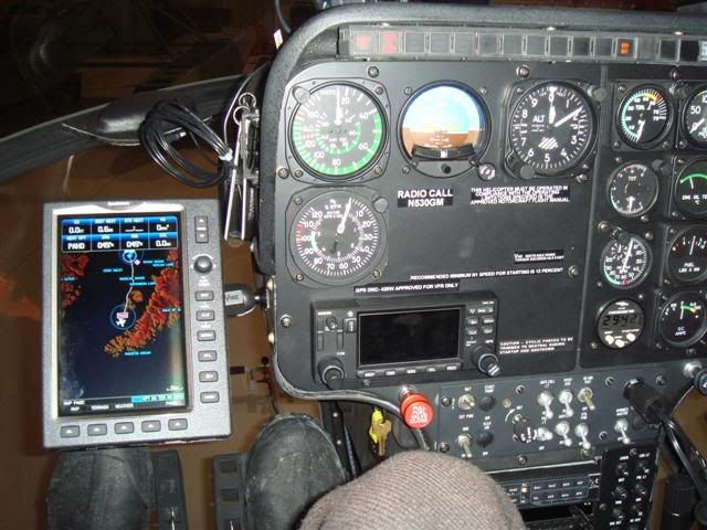
Today, we picked up a Garmin 696 that we had ordered as soon as they were announced. Turning the 696 on, we were absolutely blown away by the quality of the display. Much better than a Garmin 530 -- and somewhere between the G600 and G1000. We rigged it up in the helicopter, on a Panavise mount we use for a 496, and enjoyed flying home with it. A 496 looks very small and hard to read by comparison.

Join Date: Oct 2007
Location: airport
Posts: 343
Likes: 0
Received 0 Likes
on
0 Posts
Do you have the part number of that Panavise mount, or a close-up picture of it?
Here's a Demo on Youtube from AVweb.
Meet Garmin's 696 portable GPS, new, November, 2008. AVweb and Aviation Consumer's Paul Bertorelli walks you through the basic functionality of Garmin's latest GPSMAP showcased by Garmin at AOPA's Expo 2008 in San Jose, California.
YouTube - Garmin 696 Portable GPS Demo
Last edited by Runway101; 6th Dec 2008 at 07:53.
Thread Starter
Join Date: Mar 2008
Location: Homer, Alaska
Posts: 177
Likes: 0
Received 0 Likes
on
0 Posts
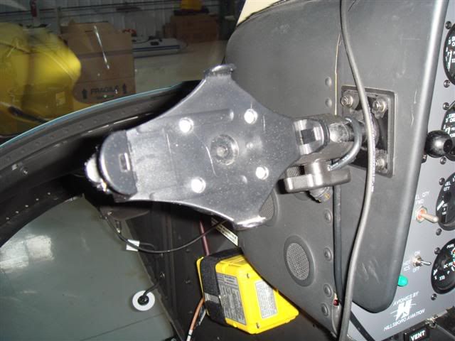
I looked at the Panavise mount and didn't see a part number. Here is a photo of the Panavise mount in another ship with a cradle for a 496. One end of the Panavise mount attaches to the back of the G600 and attaches to the Panavise arm.
Join Date: Apr 2007
Location: Center of the Universe
Posts: 645
Likes: 0
Received 0 Likes
on
0 Posts
Here is a G696 install in an Enstrom 480B. The mount attaches with thumb screws to an existing seat rail, with no new holes needed. The mount is assembled from standard RAM mount parts and can be removed within 30 sec. Had some initial problems with system crashes on the 696; downloading the latest system software (v2.40) seems to have corrected this.


Life's too short for ironing
Join Date: Dec 2001
Location: Scotland, & Maryland, USA
Posts: 1,146
Likes: 0
Received 0 Likes
on
0 Posts
EN48, and others,
Just an fyi - we got our 696 last Monday, and its still in crash mode, even with the new 2.4 software. Seems to be caused by uploading the updated flitecharts. Initially it took so long, I had to unplug everything as my pax turned up and we had to leave. It now won't accept the charts and I am having my busiest ever week, so am not at home with a good computer when Garmin help is in the office. Hopefully later this week, meantime the 696 sits in its box
So, for those new purchasers, be cautious when uploading the flitecharts. Allow at least 2.5 hrs if using a laptop and wireless. I had to pull the plug at 1hr15 and 60% completed. Or take the manual route and put them on the computer first, then transfer them onto the 696.
Join Date: Apr 2007
Location: Center of the Universe
Posts: 645
Likes: 0
Received 0 Likes
on
0 Posts
Is that a personal machine?
Join Date: Apr 2007
Location: Center of the Universe
Posts: 645
Likes: 0
Received 0 Likes
on
0 Posts
Seems to be caused by uploading the updated flitecharts.
Thread Starter
Join Date: Mar 2008
Location: Homer, Alaska
Posts: 177
Likes: 0
Received 0 Likes
on
0 Posts
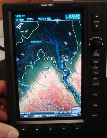
Flying in Alaska, we have downloaded the topo info onto our Garmin 396/496 units. The 696 also takes downloaded topo information. While this low res photo doesn't do it justice, the terrain detail is stunning on the 696.
Join Date: Mar 2008
Location: Indiana
Age: 67
Posts: 46
Likes: 0
Received 0 Likes
on
0 Posts
I love your 696 installation. Pretty ingenious to use the inner tracks. I move my seat to those tracks once in a while so that won't work for me.
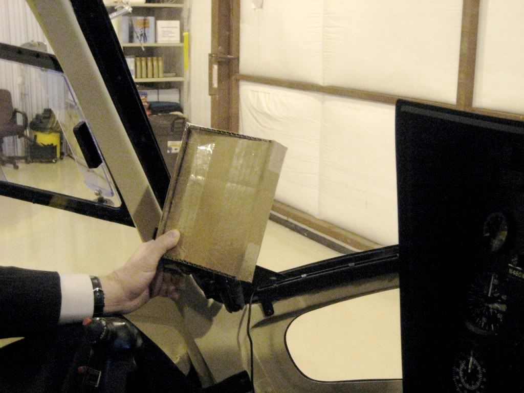
I have scoped out all of the possible mounting places...from the floor, on the center column by the compass, replacing the flipcards, etc. I have finally decided to mount it on my left side using the windshield bolts. It is just in front of the pilot's door post, and to the left of my left thigh so it is out of the way of the cyclic and my legs. I have a friend who has a 496 mounted there and it works great. He makes all entries with his left hand which in turn keeps his right hand free for the cyclic.
I hope you like my cardboard box 696. <gr>
Chuck
Join Date: Apr 2007
Location: Center of the Universe
Posts: 645
Likes: 0
Received 0 Likes
on
0 Posts
"The 696 also takes downloaded topo information"
Can you provide some guidance on how to do this. I took a quick look at the manusl and couldnt seem to find this.
Thanks.
Can you provide some guidance on how to do this. I took a quick look at the manusl and couldnt seem to find this.
Thanks.
Thread Starter
Join Date: Mar 2008
Location: Homer, Alaska
Posts: 177
Likes: 0
Received 0 Likes
on
0 Posts
You need the Map Source topo program as a source for the data. You buy an SD card, choose the topo information in your area of interest, no more than 1,224 (about) maps, and transfer the data to the SD card inserted in the 696 with the provided cable. Now you have topo data displayed on your 696. You can customize the level of detail in "map set-up" on the 696.
There is a bug, whereby routes created on the Map Source program that come over as "map" waypoints don't act properly on the flight plan page of the 696, but work fine if you create user waypoints instead of "map" waypoints. We have been discussing this with Garmin.
There is a bug, whereby routes created on the Map Source program that come over as "map" waypoints don't act properly on the flight plan page of the 696, but work fine if you create user waypoints instead of "map" waypoints. We have been discussing this with Garmin.
Join Date: Oct 2007
Location: airport
Posts: 343
Likes: 0
Received 0 Likes
on
0 Posts
My 496 comes with standard topo information as well. Just out of curiosity, are you talking about better or more detailed topo info than the 496, or does the 696 come with NO topo at all if you don't do that transfer to the SD card? Slightly confused about this after you mentioned it.
I am currently flying in the alps with my 496, and topo comes in handy.
I am currently flying in the alps with my 496, and topo comes in handy.
Join Date: Apr 2007
Location: Center of the Universe
Posts: 645
Likes: 0
Received 0 Likes
on
0 Posts
and transfer the data to the SD card inserted in the 696 with the provided cable
Thread Starter
Join Date: Mar 2008
Location: Homer, Alaska
Posts: 177
Likes: 0
Received 0 Likes
on
0 Posts
1) The Garmin 696 comes with quite a bit more map detail than, for example, a Garmin 530. The Map Source program gives you even more detail -- equivalent to a topo map.
2) On the 396/496 series, as well as the 696, I have always programmed the chip in the gps unit. I haven't tried doing it otherwise.
2) On the 396/496 series, as well as the 696, I have always programmed the chip in the gps unit. I haven't tried doing it otherwise.
Join Date: Apr 2007
Location: Center of the Universe
Posts: 645
Likes: 0
Received 0 Likes
on
0 Posts
The Map Source program gives you even more detail -- equivalent to a topo map.
Can you identify more specifically the Map Source topo map(s) you use with the 696. The one that looks most relevant on the Garmin website is this one:
TOPO U.S. 2008
Part Number: 010-11001-01
Suggested Retail Price: $ 116.65 USD
however, the 696 is not shown as a compatible GPS on the Products tab (however, the 496 is listed, which makes me believe that it will work with the 696). I need Northeast US coverage.
Thanks for any guidance you might provide.
Gatvol
Join Date: Jun 2000
Location: KLAS/TIST/FAJS/KFAI
Posts: 4,195
Likes: 0
Received 0 Likes
on
0 Posts
George
Just to drift a bit. That course that shows up on your initial post is over some seriously cold water off the spit. Good Luck. Time for a Brandy and a beer at the Salty Dog.........
Just to drift a bit. That course that shows up on your initial post is over some seriously cold water off the spit. Good Luck. Time for a Brandy and a beer at the Salty Dog.........
Join Date: Feb 2007
Location: England
Age: 56
Posts: 591
Likes: 0
Received 0 Likes
on
0 Posts
Just bought a 695 unit.
Initial impressions are bloody excellent.
Not sure where it's going to go in my machine, but I'll upload some photos when it's done.
JJ - Not a bloody word from you please !!!!
Initial impressions are bloody excellent.
Not sure where it's going to go in my machine, but I'll upload some photos when it's done.
JJ - Not a bloody word from you please !!!!


