


GCTS

Thread Starter
Join Date: Jul 2005
Location: Manchester
Age: 45
Posts: 54
Likes: 0
Received 0 Likes
on
0 Posts
GCTS
to all u 757 pilots
i fly man-tfs about ten times a year with TCX, MON and FCA and often wonder what a pilots perspective of this route is like. Departing manchester always seem to head towards ireland turn left and fly over ocean rather than land. is this a better routing for clearance or fuel efficient??? what are tenerife like to deal with on the radio. And why is it when on the return leg its always bumpy over the azores region..?? any comments appreciated
i fly man-tfs about ten times a year with TCX, MON and FCA and often wonder what a pilots perspective of this route is like. Departing manchester always seem to head towards ireland turn left and fly over ocean rather than land. is this a better routing for clearance or fuel efficient??? what are tenerife like to deal with on the radio. And why is it when on the return leg its always bumpy over the azores region..?? any comments appreciated

Join Date: Aug 2002
Location: West Sussex
Posts: 36
Likes: 0
Received 0 Likes
on
0 Posts
When I asked our flight planning guys why they route us out via the Cork region then down over the Atlantic to TFS, they told me it is often due to 2 reasons. Sometimes the winds are in our favour on the way down or back and the other reason they tell me is because it is because the route charges. It is cheaper to have the flight go down the oceanic route than go over France, Spain and Portugal. But if the winds are less favourable it may be cheaper to go over the Land route.
Join Date: Jul 2005
Location: btw SAMAR and TOSPA
Posts: 566
Likes: 0
Received 0 Likes
on
0 Posts
You won't pass over the Azores, it is Madeira what you will see.
Usually there is a change of wind zones around 33N and that's why it can be bumpy there, or you just overfly the mountains on the isles.
Usually there is a change of wind zones around 33N and that's why it can be bumpy there, or you just overfly the mountains on the isles.
Join Date: Feb 2006
Location: -
Posts: 508
Likes: 0
Received 0 Likes
on
0 Posts
The route charge is the big factor because we (Oceanic ATC) are way cheaper than the domestic radar sectors and it is a flat fee for the ATC service, irrespective of how many miles/km you travel within Oceanic Airspace.
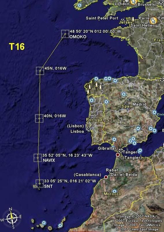
The route is known as T16: The 'oceanic' leg commences (southbound) at 'OMOKO' and heads to 45N016W (Where you'll cross from Shanwick Oceanic into Santa Maria Oceanic) 40N016W 'NAVIX' 'SNT'. Coming northbound is simply in reverse, entering Santa Maria Oceanic at NAVIX.
If you're interested see: http://en.wikipedia.org/wiki/Shanwick_Oceanic_Control
Last edited by rab-k; 19th Mar 2007 at 17:59.
