


Setting QNH/Altimeter after GPS?

Thread Starter
Join Date: Sep 2006
Location: Los Angeles, USA
Age: 52
Posts: 1,631
Likes: 0
Received 0 Likes
on
0 Posts
Setting QNH/Altimeter after GPS?
I have very little experience with GPS and mainly fly steam gauges. I was wondering if it's frowned upon to set the altimeter after the GPS altitude reading on stretches where no QNH can be obtained?

Frowned upon! Its downright bloody stupid! A pressure instrument is set to a known pressure or elevation if you have a reference.
How long do you fly for? You have a met forecast, you took off from a known elevation so you have must a reasonable idea what the QNH is or should be. The Altitude on a GPS is the least accurate part of it!
I was once involved in Research flying where we operated to 50 ft over the sea, we used a totally non standard procedure of setting the pressure altimeter to the Radar Altitude as that was invariably the most accurate datum but even then wave height may have produced spurious readings.
no QNH can be obtained?
I was once involved in Research flying where we operated to 50 ft over the sea, we used a totally non standard procedure of setting the pressure altimeter to the Radar Altitude as that was invariably the most accurate datum but even then wave height may have produced spurious readings.

Join Date: May 2001
Location: UK
Posts: 4,631
Likes: 0
Received 0 Likes
on
0 Posts
What a good question.
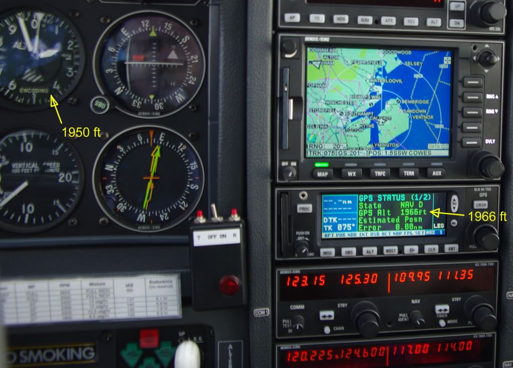
I did nearly 400nm round trip today and was comparing the GPS altitude(twin IFR certified Garmin 430s) with the altimeter (as well as a few other things). It wasnt totally scientific but IO540 is correct, the differences were very small indeed.
430s must report a RAIM error when the function is unavailable but without a RAIM error what tolerances of vertical nav. should be expected and what tolerances are assured (if any). I must do a little research when I have a sec unless anyoen knows the answers.
To answer the question if for any reason I couldnt set a pressure (I cant think why that would be so mind you) I would definetely use the GPS height to calibrate the altimeter and if the GPS height and altimeter were at variance I would definetely want to estabish why.
Join Date: Aug 2003
Location: Surrey
Posts: 1,217
Likes: 0
Received 0 Likes
on
0 Posts
As we all know the two instruments in IO's picture measure two completely different things.
The GPS is measuring the position of the aircraft, relative to the centre of mass of the earth (i.e. the thing the satellites are orbiting). The GPS then determines where it thinks the surface of the Earth is using a standard model Geoid. More sophisticated GPSs then take into account the local geoid undulation, or even the actual terrain data. The IFR GPS are pretty sharp at determining where they are in 3d, but the surface of the Earth may be in a slightly different place than the GPS thinks.
The altimeter measures the air pressure and converts the current pressure less the set pressure (the QNH) as a distance, assuming you are in a standard atmosphere. On a very cold day even only 5000 feet above the airfield that has provided the QNH, you could be 500 feet lower than the altimeter shows.
The altimeter will be very good for traffic separation as everyone sets the same reference point, but is less good for terrain avoidance on cold days.
A 'camping' GPS may have a very simple geoid model and hence not have an accurate local view of sea level (and hence get the wrong altitude).
However, like Fuji and IO have seen, once you do the temperature correction so you know what the altimeter meant to tell you! an IFR GPS (particularly one with TAWS) will give a very good true altitude
Join Date: May 2005
Location: Abroad
Posts: 1,172
Likes: 0
Received 0 Likes
on
0 Posts
IO,
What mm_ said (minus some confusion between ellipsoid, geoid, and terrain elevation but it doesn't matter).
Very briefly, a GPS measures time differences from which a series of vectors to known positions in a given reference frame are derived, from which the receiver's position in said reference frame can be obtained and compared to other positions such as that of the ground or an elevation datum. The end result is a geometric distance.
An altimeter is simply a barometer with the scale graduated in distance rather than pressure units. The equivalence between the two unit systems is given by a purely conventional model such as ISA. However, its readout being in feet or metres does not change the fact that an altimeter is solely measuring pressure, or more technically, pressure difference from a calibrated reference.
Therefore, two different instruments measuring two quite different things. Sometimes it just so happens that the numbers might about match.
To the OP:
In VFR flight, the purpose of using altimeter + QNH is to keep you vertically separated from other aircraft (+ airspace), which are meant to be observing the same convention. If you were flying on an area where everyone used GPS altitude as a reference then you would not need an altimeter at all, but I don't believe such a practice exists anywhere. In the meanwhile, if you are flying somewhere where for whatever reason you cannot obtain a QNH/QFE, then you would just simply state your reference pressure (which you will have picked more or less arbitrarily) along with your altimeter reading on any communication, e.g., "X-XXXX at 5000ft on 1020".
Join Date: Apr 2009
Location: UK
Posts: 816
Likes: 0
Received 0 Likes
on
0 Posts
It's very not cool to set an altimeter against the GPS altitude.
GPS is much less accurate vertically than it is horizontally and so GPS altitude may differ from true altitude by hundreds of feet. With a typical decision height of 200ft AGL on an ILS, that error could be enough to kill you.
Aviation altimetry is based on indicated altitude above a datum. For QNH the datum is sea level but except in perfect ISA conditions the indicated altitude above the sea level datum will not equate to true altitude because of temperature error. Temperature error affects altimeters equally (but of course not GPS) so indicated altitude remains the correct and reliable method of providing separation. Above transition altitude the standard pressure setting of 1013 is used, which introduces a further deviation from true altitude equivalent to the vertical difference between the datum 1013 pressure level and sea level.
In short, indicated altitude and GPS altitude can potentially have significantly large differences. Except in extreme weather, any QNH from within the last 6 hrs or 200 miles will probably be much more accurate than setting the altimeter against the GPS. If you can't obtain a QNH less than 6 hrs old or from within 200 miles you're doing something wrong.
Of course, sometimes the GPS alt will match the pressure altimeter perfectly, just as a stopped clock tells the correct time twice a day.
Thread Starter
Join Date: Sep 2006
Location: Los Angeles, USA
Age: 52
Posts: 1,631
Likes: 0
Received 0 Likes
on
0 Posts
It's mainly hypothetical, but I could probably foresee a couple of places where this could happen. One is the northern route crossing the atlantic (Frobisher Bay-Sondre Str�mfjord-Kulusuk) where no HF is required but depending on altitude, you're out of VHF range. Or anywhere else in sparsely populated or trafficked areas; Northern Canada, Africa, Greenland, Siberia, parts of Asia or the Pacific.
There is obviously a very hypothetical danger of flying into terrain in a place where rising terrain and lowering temp and pressure conjure if you're stuck on an old altimeter setting.
Or to give a more recent example, I took off from Lydd and went to Bembridge at 5400ft, which is just 100ft below the Class A veil. Only after I'd landed did I realize that any press altitude change along the way that I was oblivious to could have made me bust the A. Not that the QNH's were not available to me had I wanted to, but nevertheless. Sometimes you're busy watching the scenery.
Last edited by AdamFrisch; 13th Sep 2010 at 04:54.
Join Date: Jun 2003
Location: EuroGA.org
Posts: 13,787
Likes: 0
Received 0 Likes
on
0 Posts
However, like Fuji and IO have seen, once you do the temperature correction so you know what the altimeter meant to tell you! an IFR GPS (particularly one with TAWS) will give a very good true altitude
GPS is much less accurate vertically than it is horizontally
where exactly he might be that he cannot get a QNH
Europe does not have the American 18000ft transition level. It varies all over the place, and in CAS you can get a different value issued to you anyway.
Everybody, myself included, knows that barometric altimetry is the accepted standard for traffic separation, but I post this stuff just to make the point that GPS altitude is the height above mean sea level to a reasonable accuracy.
After all, all commercial GPWS systems use GPS altitude which they match against a terrain map. They can't use the baro altitude because the system has no way what the local QNH is, and if it did use it it could not be sure whether the pilot has dialed the wrong value in.
I always check the GPS altitude (on both my IFR KLN94 and the Garmin 496 which usually uses EGNOS for additional accuracy) against the altimeter before flying an approach, and if I had a big discrepancy I would re-check the QNH, and if this was still wrong (which I have never seen) then I would head somewhere with an ILS.
Last edited by IO540; 13th Sep 2010 at 08:03.
Join Date: Aug 2003
Location: Surrey
Posts: 1,217
Likes: 0
Received 0 Likes
on
0 Posts
My understanding of GPS fixes is that having the altitude assumed to be right gives a quick fix, but once you have a multi-satellite fix it is equally accurate in all directions (so say +/- 50 meters on a bad day - +/-10 on a good day for a non-EGNOS/WAAS receiver). We just perceive 50 meters vertically to be a bigger error than 50 meters laterally (and of course it is if you are trying to avoid terrain ;-)
The much bigger error is if the GPS doesn't have a clear view of where local sea level is on this part of the earth. I believe all of the TAWS ones have an accurate map of exactly where sea level is and how high the surface is above sea level. The EGNOS ones clearly know this well enough to get you to precisely 250 ft above this surface point for the LPV approaches.
A camping one may use the basic ellipsoid (thank you LH2) and be out by a considerable distance.
Join Date: Apr 2003
Location: Midlands
Posts: 2,359
Likes: 0
Received 0 Likes
on
0 Posts
The difference between GPS altitude and FL is one of the issues causing problems in the creation of a truly unified collision avoidance system. FLARM uses GPS altitude to both avoid collisions with other FLARM equipped aircraft and obstacles on the ground. Most other systems use Mode C, or a sensor calibrated to 1013, to calculate vertical separation. FLARM (despite being uncertified) appears to work well in Europe, but I have always been sceptical that the two systems could be brought together in one box. The people developing the systems have always clamed there was no problem, but I have not got my hands on one to test it yet!
Rod1
Rod1
Join Date: Jun 2003
Location: EuroGA.org
Posts: 13,787
Likes: 0
Received 0 Likes
on
0 Posts
The difference between GPS altitude and FL is one of the issues causing problems
GPS altitude is the only way to make anticollision work, because one cannot rely on the pilot setting (or even having) the right QNH.
Join Date: Apr 2003
Location: Midlands
Posts: 2,359
Likes: 0
Received 0 Likes
on
0 Posts
�GPS altitude is the only way to make anticollision work, because one cannot rely on the pilot setting (or even having) the right QNH.�
That is not the future of collision avoidance kit. The future of collision avoidance kit will be FL, it is almost a universal standard, excluding FLARM. �Being different� is only an issue if the manufacturers cannot reliably convert from one to the other. Two manufacturers are launching kit that allegedly does this.
I have configured my EFIS/GPS system and have chosen not to display GPS altitude (there are 100�s of bits of info you can choose from). As it has an altimeter built in, it may be possible to get it to alert if the two are out by more than a specified amount. If I get time I may have a play.
Rod1
Join Date: May 2007
Location: Compton Abbas
Posts: 164
Likes: 0
Received 0 Likes
on
0 Posts
What an interesting thread. I've recently been involved in the development of an aviation handheld GPS and have been pleasantly surprised by the results.
A modern GPS chipset (such as the sirfstar III) contains pretty much the same geoid correction data as many IFR GPS sets on the market. They get a fix quickly, correct the data so its reference is local mean sea level and most importantly, report the accuracy of the fix.
In the case of this device, we chose to put a little flag in the corner of the altimeter to represent the accuracy of the fix. Usually, in flight with no external antenna, the accuracy is within +/- 25ft. If it isn't, it's +/- 50ft. And this is after a short period of time for the maximum number of satellites to be acquired. Just knowing the accuracy of the information being presented is nice.
Of course this doesn't necessarily make it suitable in the context of the OP's question, since you want everybody to be using the same reference point. Let me know when you succeed in getting a bunch of pilots to all do the same thing
Join Date: Feb 2005
Location: England
Posts: 551
Likes: 0
Received 0 Likes
on
0 Posts
Originally Posted by IO540
GPS altitude is the only way to make anticollision work, because one cannot rely on the pilot setting (or even having) the right QNH.
Join Date: Jun 2003
Location: EuroGA.org
Posts: 13,787
Likes: 0
Received 0 Likes
on
0 Posts
For ACAS equipment, such as the TAS600, to work it's only necessary for mode C transponders to be correctly calibrated. The common reference pressure setting is then 1013mb, so vertical distances between aircraft can be easily calculated relative to each other, rather than using height above MSL.
It would suprise me if a FL-based TCAS system was proposed even for the very low end of GA, given how many of those people are dead against installing any electrical equipment, on the grounds that they don't have power available.
GPS altitude seems to be a really easy way to deal with this, especially with EGNOS coming in soon, offering vertical accuracy of the order of a few feet or better. So many altitude encoders are 100-200ft off...
With an altitude encoder you have no way of knowing if it is out of calibration, and if the aircraft in question does not have a transponder then the pilot may never realise it is out, whereas a GPS can easily report if there is something wrong with the accuracy of its 3D fix.
Join Date: May 2001
Location: UK
Posts: 4,631
Likes: 0
Received 0 Likes
on
0 Posts
but if encoders ever used GPS altitudes presumably a mechanism would need to be found for ensuring every GPS was set indentically. In other words there would need to be a common standard of IFR approved GPS encoders - quite possibly one would imagine, cheaper, lighter and more reliable than existing technology.
Are solar flares a worry? We have had a period of weak solar activity but history suggests that will not be the case for ever. However it also leaves me wondering if the GPS signal can be interupted by solar activity can mode c / s transmissions and even primary radar be compromised.
Solar flares will disrupt GPS in 2011 - tech - 29 September 2006 - New Scientist
Join Date: Jun 2003
Location: EuroGA.org
Posts: 13,787
Likes: 0
Received 0 Likes
on
0 Posts
Solar flares may be an issue (though I stopped reading the New Scientist many years ago, having decided a lot of the content is garbage) but there is no "setting" on a GPS. A GPS computes the 3D fix, or it doesn't.
The SIRF-3 chip used in all cheap receivers today is pretty well corrected for altitude - within maybe 20-30ft. The SIRF-2 had the famous 200ft error.
The SIRF-3 chip used in all cheap receivers today is pretty well corrected for altitude - within maybe 20-30ft. The SIRF-2 had the famous 200ft error.
Join Date: May 2001
Location: UK
Posts: 4,631
Likes: 0
Received 0 Likes
on
0 Posts
By setting I meant there would need to be some assurance that each manufacturer was installing the same chip or a chip that performed to the same specs in every unit. In other words in a world of say SIRF4 and GLASNOS5 for their to be unanimty between GPS units any where in the world a standard would have to be agreed that ensured each chip understood the world to have the same shape and would interpret the signal in the same way where ever the aircraft and at what ever height.
Perhaps that is already the case? Would every IFR GPS unit regardless of make report the same height every where in the world if you placed the two units side by side. I dont know?
In theory two encoders would behave in exactly the same way subject to the certified tolerance.
Perhaps that is already the case? Would every IFR GPS unit regardless of make report the same height every where in the world if you placed the two units side by side. I dont know?
In theory two encoders would behave in exactly the same way subject to the certified tolerance.