


VHF Line of sight maths explanation

Thread Starter
Joined: Aug 2009
Posts: 56
Likes: 0
From: EGBO
VHF Line of sight maths explanation
Can someone explain how on earth this formula was derived for the horizon ray distance (in Nm) from an airborne station? A mate gave it to me and said it came off one of the CD based training packages.
(Altitude/100)^0.5 x 12
The closest I could get assuming earth's diameter is 20924640 feet (equator) and 6076 feet per Nautical Mile is the following horrible bit of math...
(Altitude^2 + 41849280xAltitude)^0.5 / 6076
My attempt comes from a simple pythagoras application as per the attached image, and the answers are usually a bit shorter than the simple formula given at the top.
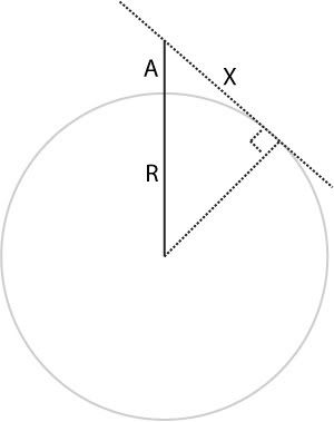
I'd love to know where these potted formulas come from. And yes, it is a rainy sunday afternoon and I have nothing better to do
(Altitude/100)^0.5 x 12
The closest I could get assuming earth's diameter is 20924640 feet (equator) and 6076 feet per Nautical Mile is the following horrible bit of math...
(Altitude^2 + 41849280xAltitude)^0.5 / 6076
My attempt comes from a simple pythagoras application as per the attached image, and the answers are usually a bit shorter than the simple formula given at the top.
I'd love to know where these potted formulas come from. And yes, it is a rainy sunday afternoon and I have nothing better to do

Joined: May 2001
Posts: 4,729
Likes: 0
From: 75N 16E
Would be easier if you used SI units rather than feet/miles....Here is an approximation:
Horizon km = Sqrt(13xh) where h is the altitude in m.
So at 1000', which is ~ 300m:
horizon= 62km
For VHF it is approximately 4/3 x horizon so radio horizon is 82km (or 44nm)
Horizon km = Sqrt(13xh) where h is the altitude in m.
So at 1000', which is ~ 300m:
horizon= 62km
For VHF it is approximately 4/3 x horizon so radio horizon is 82km (or 44nm)
Joined: Feb 2006
Posts: 181
Likes: 0
From: North of the border
Range to station
I thought the simple equation was :
Square root of the height above the station or facility times 1.23 equals range available.
I.E at 2500 feet altitude the range is ...square root of 2500 = 50 X 1.23 = 61.5 Nautical miles.
NB the 2500 feet altitude assumes the radio facility is at sea level. Adjust if the height of the station is above sea level.

Joined: Aug 2000
Posts: 3,648
Likes: 2
From: UK
(Altitude^2 + 41849280xAltitude)^0.5 / 6076
So why is the prefactor for VHF 1.2 rather than 1.06? Radio rays (and light rays) don't travel through the atmosphere in straight lines, but rather they bend, mostly because of the variation in density of air with height. So the line you have as X is actually slightly curved in the same sense as the curvature of the earth. That adds about 10% to the answer.

Joined: Jun 2003
Posts: 13,787
Likes: 0
From: EuroGA.org
Bookworm - do you think these formulae bear any relation to the real world performance of VHF?
It's a straight question, not tongue in cheek. Well, only slightly tongue in cheek
Terrain in the vicinity of the radio station makes a vast difference.
It's a straight question, not tongue in cheek. Well, only slightly tongue in cheek
Terrain in the vicinity of the radio station makes a vast difference.
Joined: Dec 2006
Posts: 223
Likes: 0
From: On the Rump of Pendle Hill GB
Being Educated in Yorkshire, I dont have the ability to do complex Logs and such like, but whilst be taught to fly the Helis I now fly, I was told by several CFis , " If you can see it, you can talk to it", strange thing is it seems to work!.
Peter R-B
VfrpilotPB
Peter R-B
VfrpilotPB
Joined: Oct 2009
Posts: 14
Likes: 0
From: West Pacific
Aviation Formulary
For all your aviation maths, go here to view the Aviation Formulary:
Aviation Formulary V1.44
Distance to horizon
At a height h above the ground, the distance to the horizon d, is given by:
d = sqrt(2*R*h/b)
b = 0.8279 is a factor that accounts for atmospheric refraction and depends on the atmospheric temperature lapse rate, which is taken to be standard.
R is the radius of the earth. Note that the earth is assumed smooth- likely only true over the oceans!
For h in feet and d in nm:
d =1.17*sqrt(h)
i.e. from 10000 feet, the horizon is 117nm away
(Reference Bowditch American Practical Navigator (1995) Table 12.)
Joined: Jun 2003
Posts: 13,787
Likes: 0
From: EuroGA.org
It seems obvious to me, from flying, that one runs out of signal strength long before it gets blanked by the earth's curvature.
On top of that, a lot of station have terrain shielding issues. Try speaking to e.g. Valley (in N Wales) - at any level including say FL100.
On top of that, a lot of station have terrain shielding issues. Try speaking to e.g. Valley (in N Wales) - at any level including say FL100.
Joined: Feb 2007
Posts: 4,598
Likes: 0
From: Amsterdam
Could someone please explain what on earth use this would be to anyone with a light single strapped to their arse?
But it's totally irrelevant for VHF communications because VHF stations all have a Designated Operational Coverage (or whatever the name is). Usually expressed as a maximum altitude & maximum distance to station. If you are within this DOC you should have good VHF reception (except if there are terrain issues like IO540 mentioned) and if you transmit outside the DOC, you might be interfering with the DOC of another station which happens to have the same frequency.
Joined: Sep 2006
Posts: 1,434
Likes: 0
From: Scotland
Thank you Backpacker, But I don't have a VOR either. I navigate by map & compass, with handheld Memory Map GPS as primary awareness.
I can see no time that I would ever need to work out such a piece of trigonometry whilst airborne.
The fact that there are so many variables other than the triangle, terain, atmopherics, signal strength, etc, would negate any meaningfull solution.
I seem to remember that a geostatic orbit distance around a planet worked out at approximately the circumference of the planet. Now, what use that is or why I discovered it I fail to remember.
Joined: Aug 2003
Posts: 1,218
Likes: 0
From: Surrey
It is of course totally irrelevant to someone flying at low altitude with no VOR (and probably no other ground based radio nav aids). Not everyone who straps a single to their backside operates in the same way. It is useful for predicting when you have the potential to hear a ground station (which given the much higher power output and good antenna setup tend to achieve their theoretical transmit distance). This can be useful when you are on a long transit and have been relaying via overhead CAT, and as others have said, when you should expect VOR or other VHF signal reception as you come back into range of civilisation.
Beacon Outbound
Joined: Mar 2002
Aviation Qualifications: ATPL
Posts: 710
Likes: 22
From: "Home is were the answer machine is"
It seems obvious to me, from flying, that one runs out of signal strength long before it gets blanked by the earth's curvature.
It will probably go a bit further than the visual horizon. Put 'Fresnel zone' in google and enjoy the read.
Beacon Outbound
Joined: Mar 2002
Aviation Qualifications: ATPL
Posts: 710
Likes: 22
From: "Home is were the answer machine is"
It is useful for predicting when you have the potential to hear a ground station (which given the much higher power output and good antenna setup tend to achieve their theoretical transmit distance).
Joined: Aug 2003
Posts: 1,218
Likes: 0
From: Surrey
The gain works both ways of course. However, typical airborne units will probably be 10 watts, whereas ground should be at least 20 and potentially 50 or more watts - so they shout louder and can be heard farther than they can hear.
Equally, a good ground antenna (assumed to be a given) and a good airborne antenna (much less obviously true in typical spamcans) will work much better than the same ground station with a typical 'club' airborne installation.
Equally, a good ground antenna (assumed to be a given) and a good airborne antenna (much less obviously true in typical spamcans) will work much better than the same ground station with a typical 'club' airborne installation.
Joined: Jun 2003
Posts: 13,787
Likes: 0
From: EuroGA.org
Your A/C radio has enough TX power to reach the visual horizon.
Joined: Jun 2009
Posts: 76
Likes: 0
From: UK
I have often found that VHF reception is affected by many unexpected factors : for example, in France, luncheon often renders radio completely useless, as does the airborne use of the phrase "I say, you chaps" anywhere near Paris ...