


Chalkie's Henshaw record attempt is well under way

Thread Starter
Join Date: Jan 2008
Location: uk
Age: 57
Posts: 119
Likes: 0
Received 0 Likes
on
0 Posts
70 year old speed record, can it be broken
An interesting article in the latest LAA mag. Steve Noujian is attempting to break Alex Henshaws speed record to cape town and back.
12,754 miles completed in 79 hours flight time.
Good luck to him, it's amazing the record still stands.
Is it possible considering todays airspace?
12,754 miles completed in 79 hours flight time.
Good luck to him, it's amazing the record still stands.
Is it possible considering todays airspace?

Join Date: Jun 2003
Location: EuroGA.org
Posts: 13,787
Likes: 0
Received 0 Likes
on
0 Posts
What plane must this be done in?
It's 161.44kt. Any turboprop can beat this easily, and with 2 pilots one certainly would beat the average.
A Malibu Mirage will cruise at 200+ kt TAS so that would beat it. You'd have to go IFR to get the TAS out of it though.
It's 161.44kt. Any turboprop can beat this easily, and with 2 pilots one certainly would beat the average.
A Malibu Mirage will cruise at 200+ kt TAS so that would beat it. You'd have to go IFR to get the TAS out of it though.
Join Date: Jul 2000
Location: London
Posts: 2,916
Likes: 0
Received 0 Likes
on
0 Posts
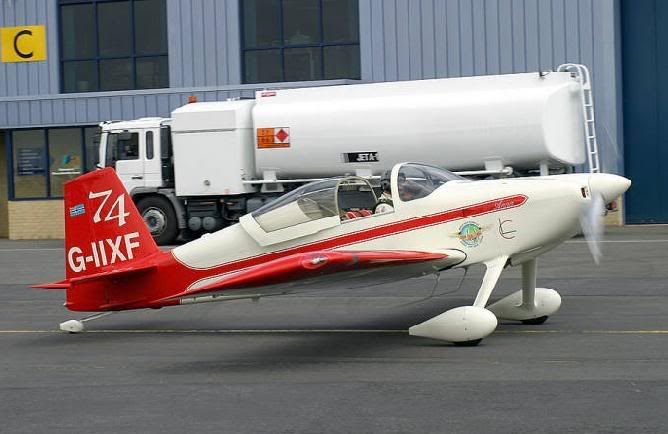
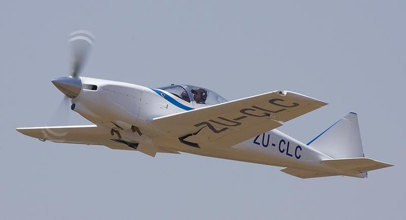
Steve Noujaim, a Captain with Virgin Atlantic, aerobatics instructor and display pilot is attempting to beat the record from London in a home-built Vans RV 7
�Chalkie� Stobbart, an Airbus A340 Captain with South African Airways and very experienced long-distance light aircraft pilot, is attempting to break the record from Cape Town in an Osprey GP 4 homebuilt.
IO540
Landplane with internal combustion engine and, to break one of Henshaw's records, take-off weight 500 to 1000 kg.
Link: FAI records
As far as I know (open to correction) the FAI no longer distinguishes solo or multi-crew but, even so, I doubt if many people would regard the record as truly broken except by a solo pilot.
Amazingly, there was only a 13 minute difference between Henshaw's airborne times to and from Cape Town.
FL
Good luck to him, it's amazing the record still stands.
In Henshaw's days we (the UK) owned/ran most of the places enroute and
Consuls/Embassies/Ambassadors would pre-arrange landing sites/refuelling/overflight permissions/diplomatic clearances, etc, etc,
Not so nowadays. It will be far more difficult!
UV


Join Date: Aug 2008
Location: long left base EGCC
Posts: 100
Likes: 0
Received 0 Likes
on
0 Posts
Landplane with internal combustion engine and, to break one of Henshaw's records, take-off weight 500 to 1000 kg
If that's the case, does anyone know which London airport / airfield is used for such a record attempt ?
Surely light singles like these are not permitted in or out of LHR or LGW ?
Join Date: Jun 2003
Location: EuroGA.org
Posts: 13,787
Likes: 0
Received 0 Likes
on
0 Posts
Below 1000kg is pretty restrictive...
The homebuilts have to go VFR but I doubt anybody will care
On a trip like this you would get an overflight agent to book the permits, crew visas, fuel in drums, etc. Lots of people have done it.
How can an RV7 beat the speed record?
You can land a single at Gatwick - it is open to VFR etc. Just costs about �500. Only Heathrow and London City are actually formally closed to light GA.
Join Date: Jan 2003
Location: Surrey Hills
Posts: 1,478
Likes: 0
Received 0 Likes
on
0 Posts
Will the attempts be made without using GPS?
Hollow victory if achieved [if only because Henshaw's record has stood for so long it should be 'frozen'].
Anyway good luck with all the paperwork and happy landings......
Hollow victory if achieved [if only because Henshaw's record has stood for so long it should be 'frozen'].
Anyway good luck with all the paperwork and happy landings......
Join Date: Jun 2003
Location: EuroGA.org
Posts: 13,787
Likes: 0
Received 0 Likes
on
0 Posts
I don't think it was hard navigation 70 years ago, if he more or less went down the east coast and anyway there was no CAS to bust, and no radar with which to get tracked. If one tried that today, one would get shot down very early in Egypt...
Join Date: Aug 2000
Location: S Warwickshire
Posts: 1,214
Likes: 0
Received 0 Likes
on
0 Posts
Henshaw's challenge was to beat the record using no more than the 200HP of the Gipsy engined Mew-Gull. He was keen for people to attempt to beat him.
I presume the day-only restriction can be exempted, as it certainly isn't possible otherwise.
A well set up RV-7 with 200HP should be able to sustain 180KTAS+ at altitude and maybe nearer the 200KTAS recommended Vne.
But even at that there will be precious little time for re-fuelling, maintenance, sleep and any other luxuries.
I wish them both well and await the outcome with interest.
That's not very generous IO 540. Have you seen the picture on the back of "Flight of the Mew Gull" with a batered and bruised Henshaw being helped out of the cockpit at Croydon? And I don't think the East coast would be very safe/practical in a single these days, according to my chums in Kenya.
Join Date: Jul 2000
Location: London
Posts: 2,916
Likes: 0
Received 0 Likes
on
0 Posts
IO540
Henshaw 'more or less' went down the West coast.
His route was Gravesend � Oran � Gao � Libreville � Mossamedes - Cape Town.
'More or less' included crossing the Sahara so I suppose it depends in part upon whether you regard 1300+ miles across the Sahara with only a compass as "hard navigation."
And upon whether navigating through severe equatorial storms over the Congo, and cloud virtually down to the deck at Mossamedes, counts as hard navigation?
And trying to find tiny air strips in the middle of nowhere in order to refuel?
Much of the above was at night.
And all with no navigation aids except a compass and a stopwatch, no radio - and no weather forecasts (thus no wind information) other than those given to him at Gravesend on departure and at Cape Town for the return flight.
I always found the 1:60 rule quite difficult in the air, even with lots of terrain features which (in theory) were easily identifiable. That wasn't an option over much of Henshaw's route: virgin territory with identifiable features few and far between, and very hostile terrain below.
A friend and I flew the Atlantic in the days before GPS, but at least we had some navigational aids and, on some legs, airliners passing above us so we knew we were on track - they relayed our position reports, and also obtained weather en route and at our destination.
Lots of people may have flown s/e London - Cape Town, but no-one has broken the record.
BTW, did they fly East or West coast?
West is more challenging/risky - as it was in Henshaw's day - but it's about 400 miles shorter which is why he chose it.
C172 Hawk XP
Henshaw took off from what was then Gravesend airfield. I think Biggin Hill is probably the nearest current airfield.
He landed at Wingfield aerodrome, Cape Town which no longer exists.
The nearest airfield now is SA AFB Ysterplaat, which is very nearby.

I'm sure the SAAF would allow a record attempt flight to land at Ysterplaat but, even if not, then Stellenbosch is only a few minutes flying time away, in a beautiful location in the Winelands.
 Stellenbosch 2005
FL
I don't think it was hard navigation 70 years ago, if he more or less went down the east coast
His route was Gravesend � Oran � Gao � Libreville � Mossamedes - Cape Town.
'More or less' included crossing the Sahara so I suppose it depends in part upon whether you regard 1300+ miles across the Sahara with only a compass as "hard navigation."
And upon whether navigating through severe equatorial storms over the Congo, and cloud virtually down to the deck at Mossamedes, counts as hard navigation?
And trying to find tiny air strips in the middle of nowhere in order to refuel?
Much of the above was at night.
And all with no navigation aids except a compass and a stopwatch, no radio - and no weather forecasts (thus no wind information) other than those given to him at Gravesend on departure and at Cape Town for the return flight.
I always found the 1:60 rule quite difficult in the air, even with lots of terrain features which (in theory) were easily identifiable. That wasn't an option over much of Henshaw's route: virgin territory with identifiable features few and far between, and very hostile terrain below.
A friend and I flew the Atlantic in the days before GPS, but at least we had some navigational aids and, on some legs, airliners passing above us so we knew we were on track - they relayed our position reports, and also obtained weather en route and at our destination.
Lots of people have done it.
BTW, did they fly East or West coast?
West is more challenging/risky - as it was in Henshaw's day - but it's about 400 miles shorter which is why he chose it.
C172 Hawk XP
Henshaw took off from what was then Gravesend airfield. I think Biggin Hill is probably the nearest current airfield.
He landed at Wingfield aerodrome, Cape Town which no longer exists.
The nearest airfield now is SA AFB Ysterplaat, which is very nearby.
I'm sure the SAAF would allow a record attempt flight to land at Ysterplaat but, even if not, then Stellenbosch is only a few minutes flying time away, in a beautiful location in the Winelands.
FL
Last edited by Flying Lawyer; 2nd Dec 2008 at 11:32.
Join Date: Jul 2000
Location: London
Posts: 2,916
Likes: 0
Received 0 Likes
on
0 Posts
Yes.
'The Flight of the Mew Gull'
ISBN-10: 1840370211
ISBN-13: 978-1840370218
I bought a hardback copy some time ago on either Amazon or eBay.
A paperback edition was published in 1998.
'The Flight of the Mew Gull'
ISBN-10: 1840370211
ISBN-13: 978-1840370218
I bought a hardback copy some time ago on either Amazon or eBay.
A paperback edition was published in 1998.
Join Date: Jun 2003
Location: EuroGA.org
Posts: 13,787
Likes: 0
Received 0 Likes
on
0 Posts
There are two separate areas of interest here: breaking the speed record, and doing it using dead reckoning.
I think both would be very hard today, not because the fast enough aircraft is not available but because of the combination of
- controlled airspace making it hard to do it "VFR" (legally VFR) and there is no IFR certified aircraft < 1000kg that I know of
- highly militarised countries enroute, making it a logistical job to do the whole flight virtually nonstop (PPR, overflight permissions, etc)
- fuel availability
GPS would I am sure help greatly, and I think would be highly desirable to avoid getting lost and getting into trouble. 70 years ago, the only "trouble" would presumably be getting lost and dying somewhere. Today you might get shot.
At least one can get charts - the ONC ones cover Africa I think. And one can get them georeferenced for Oziexplorer so navigation would be a piece of cake. The Q is whether such a flight would be accepted if it broke the record.
I think today one would have to do something like what Simon Oliphant-Hope did i.e. with a logistics backup back home, always available, and a satellite phone connection to sort out PPR well ahead of route. Even in Spain or Italy, supposedly modern countries, PPR can never be assumed no matter how many faxes one has sent out.
Join Date: Jul 2000
Location: London
Posts: 2,916
Likes: 0
Received 0 Likes
on
0 Posts
IO540
True, but what you said was "I don't think it was hard navigation 70 years ago."
There are two separate areas of interest here: breaking the speed record, and doing it using dead reckoning.
Join Date: Jun 2003
Location: EuroGA.org
Posts: 13,787
Likes: 0
Received 0 Likes
on
0 Posts
OK, I forgot you are a lawyer, so let me rephrase it 
Accurate navigation was hard 70 years ago, but accurate navigation wasn't necessary 70 years ago.
Today, accurate navigation is necessary; not for flying/survival reasons but to avoid getting into legal trouble.
Accurate navigation was hard 70 years ago, but accurate navigation wasn't necessary 70 years ago.
Today, accurate navigation is necessary; not for flying/survival reasons but to avoid getting into legal trouble.
Join Date: Oct 2008
Location: Netherlands
Age: 52
Posts: 121
Likes: 0
Received 0 Likes
on
0 Posts
Some more info on Steve Noujaim and his attempt at the record can be found here:
The Cape Challenge, flight record bid
I can very much recommend reading 'Flight of the Mew Gull' even if you're not after the record yourself.
The Cape Challenge, flight record bid
I can very much recommend reading 'Flight of the Mew Gull' even if you're not after the record yourself.
Join Date: May 2002
Location: dubai
Posts: 942
Likes: 0
Received 0 Likes
on
0 Posts
Sorry for the thread drift but I have some possibly interesting but useless information.
I have flown a lot in Africa for years.
I did find the aeronautical maps had "too much" detail, at times, especially in desert or very remote areas.
Although I carried aeronautical charts on board the best for eye ball navigation were the Michelin road maps, especially at "altitude". We only dreamed about something like GPS in those days. Very few NDB's and less VOR's. I found a line on the map of course, with 10 nm marks, fly the mag trk on the compass and after say 5 hrs at 150 -180kts, it was incredible how close to flight plan you could be. At 10,000 to 12,000 feet there did not seem to be a whole lot of wind most of the time.
That's how we did it in my day.
Last edited by doubleu-anker; 2nd Dec 2008 at 15:31.